Los Vaqueros Reservoir

Last updated
Los Vaqueros Reservoir
Los Vaqueros Reservoir aerial.jpg
Aerial view from the southeast
Relief map of California.png
Red pog.svg
Los Vaqueros Reservoir
Usa edcp relief location map.png
Red pog.svg
Los Vaqueros Reservoir
Location Diablo Range,
Contra Costa County, California
Coordinates 37°49′13″N121°44′02″W / 37.82025°N 121.7338°W / 37.82025; -121.7338 Coordinates: 37°49′13″N121°44′02″W / 37.82025°N 121.7338°W / 37.82025; -121.7338
Type reservoir
Basin  countriesUnited States
Max. length2.5 mi (4.0 km)
Max. width2.5 mi (4.0 km)
Surface area1,400 acres (570 ha)
Average depth170 ft (52 m)
Max. depth170 ft (52 m)
Water volume160,000  acre⋅ft (0.20 km3)
Surface elevation524 ft (160 m) [1]
Settlements Brentwood, Livermore

The Los Vaqueros Reservoir and watershed is located in the northern Diablo Range, within northeastern Contra Costa County, northern California. It was completed by the Contra Costa Water District (CCWD) in 1998 to improve the quality of drinking water for its 550,000 customers in Central and Eastern Contra Costa County. The reservoir is accessible via Vasco Road, a road which connects Brentwood and Livermore.

Contents

Some 20,000 acres of land was acquired to provide for construction of the dam and its 1500-acre reservoir, as well as protection of 19,300 acres of associated watershed.

History

Los Vaqueros Reservoir is named for the 19th-century Mexican Rancho Cañada de los Vaqueros land grant that included its site. The Spanish word vaquero means "cowboy" in English.

Incursions of saline water into the Sacramento-San Joaquin River Delta from the San Francisco Bay has been a concern since the 1870s. This concern was one of the reasons CCWD was formed in 1936. A drought in 1977 caused salinity levels for the water supply to exceed public health standards. It forced CCWD to ration deliveries of fresh water to its customers. [2]

An expansion project begun in 2010 raised the height of the dam to increase storage capacity from 100,000 acre-ft to 160,000 acre-ft of water. At the start of February 2017, the reservoir contained 133,700 acre-feet (164,900,000 m3) of water. [3]

Project requirements

In 1988, voters approved funding of the Los Vaqueros Reservoir project to begin design and construction. It was a massive project. In addition to building the $61 million, 192-foot-tall dam, the district had to:

Construction timeline

2010–2012 expansion project

In March, 2010, CCWD approved a capacity increase of 60,000 acre-feet (74,000,000 m3). [4] Costs will be passed on to those that receive water from the water District. Mitigation for the loss of sensitive wildlife habitat will be necessary. This increase is scheduled for completion in 2012. On July 14, 2012, the following portions of the expansion project were opened to the public:

Barnard Construction Company, which was hired by CCWD to perform the reservoir expansion, employed Mechanically stabilized earth (MSE) technology to create the dam walls. Barnard subcontracted Reinforced Earth Company (RECo) to design and supply the MSE walls using its proprietary GeoMega™ MSE wall system, which utilizes precast concrete facing panels with GeoStrap® (high tenacity polymeric strips) as soil reinforcements. [lower-alpha 1] RECo also provided the precast concrete barrier and coping segments atop the newly expanded dam, reducing both cost and construction time for completion. [5]

The south end of the reservoir reopened in October 2012, after revamping the marina. [7] The storage level reached 132,900 acre-feet in 2013, before the CCWD began drawing down the level to serve user needs during the recent drought. Heavy rains in the watershed since October 2016, increased the level to more than 133,700 acre-feet (164,900,000 m3) at the end of January 2017, the all-time record for the reservoir. [3]

2017 expansion study

A coalition of 12 Bay Area water agencies formally approved a study of expanding the reservoir by increasing the existing dam height by another 55 feet (17 m) to a total height of 273 feet (83 m). [lower-alpha 2] The proposed project would increase capacity of the reservoir from the present 160,000 acre-feet (200,000,000 m3) to 275,000 acre-feet (339,000,000 m3) at an estimated cost of $800 million. [8]

In August 2017, the East Bay Times reported that the estimated cost of the expansion had increased from the previously announced $800 million to $914 million. It also reported that six environmental groups had written a letter of support for the proposed expansion to the California Water Commission. [lower-alpha 3] Groups signing the letter included Nature Conservancy, Audubon California, Planning and Conservation League, California Waterfowl Association, Defenders of Wildlife, and Point Blue Conservation Science. If the Commission grants the funds, construction could start in 2022 and be completed in 2026, according to the Times. [9]

Recreation

The lake has boating and fishing George Miller (7592138652).jpg
The lake has boating and fishing

Certain types of recreation are allowed on the lake. These include boating and fishing. Boats may be rented at the marina, but no boats may be brought into the watershed. Gasoline-powered boats are not allowed. Swimming and wading are forbidden.

Hiking trails

Badger Pass and Oak Savannah Loop Trail is a loop that is rated as "Hard" by all trails.com. Beginning near the north end of the lake, it is 7.9 miles (12.7 km) long and has an elevation gain of 2,125 feet (648 m). Accessible year-round for hiking, walking, nature trips and birding. [10]

Los Vaqueros Dam Trail is rated "Moderate" for difficulty by all trails.com.

Los Vaqueros Shoreline Loop Trail is rated "Moderate" for difficulty by all trails.com.

Watershed description

The Los Vaqueros watershed has been preserved as 19,300 acres (78 km2) of protected open space surrounding the 1,500-acre (6.1 km2) reservoir. Water is pumped into the reservoir from a Delta intake on Old River in the Sacramento-San Joaquin Delta. The intake is located just east of Discovery Bay. Water is pumped into the reservoir when salinity is low, and used for drinking water when salinity in the Delta is too high. Water from the reservoir is released via a pipeline to the 48-mile (77 km) Contra Costa Canal, which conveys water to six water treatment plants throughout the Water District's service area. The reservoir can store up to 160,000 acre-feet (200,000,000 m3) of water. The earthen dam is 192 feet (59 m) high with a 1,000-foot (300 m) crest length. It is made of 2.7 million cubic yards of fill material.

The Watershed hosts the Mallory Ridge RAWS weather data collection site on the ridge above the Marina. It is maintained by the Los Vaqueros Watershed staff and linked to the National Fire Weather System. [11]

Other benefits of the reservoir include water storage for drought or emergencies, a protected open space, and recreation. There are 55 miles (89 km) of hiking trails in the watershed. The watershed is open for fishing, hiking and other activities year-round. Electric rental boats are available, but no outside boats can be launched on the lake. [12] No swimming is allowed in the reservoir.

Potential for further expansion

An additional expansion of Los Vaqueros to a capacity of 275,000 acre-feet (339,000,000 m3) is again being discussed by CCWD and other water agencies in Northern California. This goal was considered when the reservoir was first conceived, then revived in 2010 when the first expansion was being planned. Both times it was discarded because CCWD could find no other agencies who could put up sufficient money. [13]

According to CCWD, the other public agencies that are involved as partners in current planning for the Phase III expansion are: [14]

Wildlife protection

Another benefit of the watershed is the protection of nearly 20,000 acres (81 km2) of wildlife habitat in Eastern Contra Costa County. The watershed is home for many rare, threatened and endangered species including fairy shrimp, bald and golden eagles, Alameda whipsnake, western pond turtle, California tiger salamander, California red-legged frog, San Joaquin kit fox, and the San Francisco dusky-footed wood rat. It also provides habitat for hundreds of common plant and animal species in the area. Strict environmental commitments with State and federal agencies, and a commitment to preserving the resource help preserve this site.

As of February 17, 2017, seven of the trails on the Los Vaqueros property have been temporarily closed to protect possible golden eagle nests. Four pairs of eagles have exhibited nesting behavior, according to CCWD. The number may change during the spring. More trails may be closed, or some that have been closed may be reopened, depending on how productive the nests are. The closures typically last until late May or June, when the eaglets are fledged. [3]

Visiting Los Vaqueros

The north entrance is about 7 miles (11 km) south of Brentwood on Walnut Blvd, leading to the main parking area and is near the start of the Interpretive Center and the main hiking trails. The south entrance is off of Vasco Road, north of Livermore and leads to the marina area and four fishing piers. There is no road inside the property that connects the two entrances. Outside boats and pets may not be brought into the watershed. [15]

Notes

  1. The GeoMega™ MSE system had previously been used in marine environments where corrosion made steel reinforcement an undesirable choice. [5]
  2. If implemented, the expansion would make Los Vaqueros Dam the second-tallest dam in the Bay Area. The Warm Springs Dam on Lake Sonoma near Healdsburg, California is already 319 feet (97 m) tall. [8]
  3. The Commission is scheduled to decide on whether to grant funds to this project from stat Proposition 1, which voters approved in 2014. The decision is scheduled to be madden June 2018. [9]

See also

Related Research Articles

Brentwood, California City in California, United States

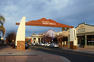
Brentwood is a city in Contra Costa County, California, United States. It is located in the East Bay region of the San Francisco Bay Area. The population is 51,481 as of 2010, an increase of 121 percent from 23,302 at the 2000 census.

East Bay Municipal Utility District

East Bay Municipal Utility District (EBMUD), colloquially referred to as "East Bay Mud", is a public utility district which provides water and sewage treatment services for an area of approximately 331 square miles (860 km2) in the eastern side of the San Francisco Bay. As of 2018, EBMUD provides drinking water for approximately 1.4 million people in portions of Alameda County and Contra Costa County in California, including the cities of Richmond, El Cerrito, Hercules, San Pablo, Pinole, Lafayette, Moraga, Orinda, Danville, Oakland, Piedmont, Emeryville, Berkeley, Albany, Alameda, San Leandro, neighboring unincorporated regions, and portions of cities such as Hayward and San Ramon. Sewage treatment services are provided for 685,000 people in an 88-square-mile area. EBMUD currently has an average annual growth rate of 0.8% and is projected to serve 1.6 million people by 2030. Headquartered in Oakland, EBMUD owns and maintains 2 water storage reservoirs on the Mokelumne River, 5 terminal reservoirs, 91 miles (146 km) of water transmission aqueducts, 4,100 miles (6,600 km) of water mains, 6 water treatment plants (WTPs), 29 miles (47 km) of wastewater interceptor sewer lines and a regional wastewater treatment facility (WWTF) rated at a maximum treatment capacity of 320 MGD.

Don Pedro Reservoir

Don Pedro Reservoir, also known as Lake Don Pedro, is a reservoir formed by the construction of the New Don Pedro Dam across the Tuolumne River in Tuolumne County, California, United States.

San Luis Dam Dam in Merced County, California

San Luis Dam is a major earth-filled dam in Merced County, California, which forms San Luis Reservoir, the largest off-stream reservoir in the United States. The dam and reservoir are located in the Diablo Range to the east of Pacheco Pass and about 10 miles (16 km) west of Los Banos. San Luis Dam, a jointly-owned state and federal facility, stores more than 2 million acre feet (2.5 km3) of water for the California State Water Project and the federal Central Valley Project. Although the dam is located in the valley of San Luis Creek, the majority of its water comes from man-made aqueducts which are supplied from other rivers in Northern California.

Morgan Territory Region in California

Morgan Territory is an historic ranching area on the east side of Mount Diablo in the San Francisco East Bay's Contra Costa County. It was named after Anglo-American pioneer Jeremiah Morgan, who acquired 2000 acres and developed a ranch here, starting in 1857.

Folsom Lake Reservoir on the American River in the Sacramento metropolitan area

Folsom Lake is a reservoir on the American River in the Sierra Nevada foothills of California, United States.

John A. Nejedly

John Albert Nejedly was a district attorney and Republican state senator in California who represented Contra Costa County from 1958 to 1980.

Briones Reservoir

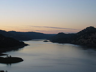
Briones Reservoir is an open cut terminal water storage reservoir located in western Contra Costa County, in the East Bay region of the San Francisco Bay Area, California.

Contra Costa Canal

The Contra Costa Canal is a 47 mi (76 km) aqueduct in the U.S. state of California. Its construction began in 1937, with delayed completion until 1948 due to World War II shortages in labor and materials. A portion of the canal's right of way has been developed as the Contra Costa Canal Regional Trail, a biking and walking trail, and is managed by the East Bay Regional Park District.

Lafayette Reservoir

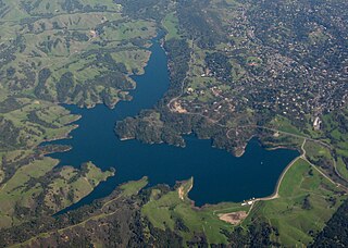
The Lafayette Reservoir is an open-cut human-made terminal water storage reservoir owned and operated by the East Bay Municipal Utility District (EBMUD). Completed in 1933, it was intended solely as a standby water supply for EBMUD customers. EBMUD opened the reservoir for public recreation in 1966. It is located off of California State Route 24 and a mile from the Lafayette BART station, in Contra Costa County, California, United States. This all-year, day-use area is ideal for hiking, jogging, fishing, boating and picnicking. The reservoir is on the Lafayette-Orinda border. The reservoir is on a 925-acre (3.74 km2) site and holds 1.4 billion US gallons (5,300,000 m3)

Anderson Lake (California)

Anderson Lake, also known as Anderson Reservoir, is an artificial lake in Santa Clara County, California, United States, near Morgan Hill. The reservoir is formed by the damming of Coyote Creek just below its confluence with Las Animas Creek. A 4,275-acre (1,730 ha) county park surrounds the reservoir and provides limited fishing, picnicking, and hiking activities. Although swimming is prohibited, boating, water-skiing and jet-skiing are permitted in the reservoir.

Mokelumne Aqueduct

The Mokelumne Aqueduct is a 95-mile (153 km) water conveyance system in central California, United States. The aqueduct is supplied by the Mokelumne River and provides water to 35 municipalities in the East Bay in the San Francisco Bay Area. The aqueduct and the associated dams, pipelines, treatment plants and hydroelectric system are owned and operated by the East Bay Municipal Utility District (EBMUD) and provide over 90 percent of the water used by the agency.

Marsh Creek (California)

Marsh Creek is a stream in east Contra Costa County, California in Northern California which rises on the eastern side of Mount Diablo and flows 30 miles (48 km) to the Sacramento–San Joaquin River Delta at Oakley, California, near Big Break Regional Shoreline. The creek flows through Marsh Creek State Park (California), where water is impounded to form Marsh Creek Reservoir, then through the city of Brentwood, California.

Calero Reservoir

Calero Reservoir, also called Calero Lake, is a reservoir in San Jose, California, located in the Calero neighborhood of Almaden Valley in South San Jose. It is the site of Calero County Park, which also includes a large area covering the lake and hundreds of acres of hills around it.

Nacimiento Dam Dam in San Luis Obispo County, California

Nacimiento Dam is a dam on the Nacimiento River about 10 miles (16 km) northwest of Paso Robles, California in the United States. The primary purpose of the dam is to provide groundwater recharge for agriculture in Monterey County and northern San Luis Obispo County supported by the Salinas Valley aquifer, as well as flood control, domestic water supply, and hydropower. It forms Lake Nacimiento, popular for boating, fishing and camping, and known locally as the "Dragon Lake" due to its shape.

Vasco Caves Regional Preserve is a natural and cultural preserved area located on the eastern slope of Mount Diablo, on Vasco Road within eastern Contra Costa County, California. It was created to preserve wildlife habitats and California chaparral and woodlands native plant communities, and Native American rock art.

Pacheco Reservoir Dam in Santa Clara County, California

Pacheco Reservoir is an artificial lake or reservoir in the Diablo Range in California, U.S.A., formed by a dam on the north fork of Pacheco Creek. Located north of State Route 152 in eastern Santa Clara County, the lake is about an hour's drive from downtown San Jose.

Upper San Leandro Reservoir

Upper San Leandro Reservoir is an artificial lake in Alameda County and Contra Costa County, California which provides water for the East Bay Municipal Utility District (EBMUD). It is impounded by the earth-filled San Leandro Dam on San Leandro Creek, located at the southeast end of the lake.

The Contra Costa Water District (CCWD) is an agency that was created in 1936 to supply water for consumers in eastern Contra Costa, California. It is now one of the largest water districts in California, serving about 500,000 people in Central and Eastern Contra Costa County.

References

  1. Aquafornia blog: Contra Costa Water District Press Release December 9, 2011.
  2. 1 2 3 4 5 6 Los Vaqueros Project History Archived 2007-04-07 at the Wayback Machine .
  3. 1 2 3 "Water Level at Los Vaqueros Reservoir Rises to a New High." Contra Costa Water District Press Release. February 3, 2017. Accessed February 18, 2017.
  4. Roberts, Dave. "Reservoir expansion could impact wildlife." Brentwood Press. August 6, 2010. p. 15A.
  5. 1 2 3 "Los Vaqueros Reservoir." Reinforced Earth Company. 2017. Accessed June 24, 2017
  6. Los Vaqueros Reservoir & Watershed
  7. King, Paula. San Jose Mercury News. "More in Reservoir." November 11, 2012.
  8. 1 2 Rogers, Paul. "Drought insurance? $800M proposal would expand Los Vaqueros Reservoir." East Bay Times. July 4, 2017. Accessed July 4, 2017.
  9. 1 2 Cuff, Denis. "East Bay reservoir expansion plan wins support of environmental groups. East Bay Times. August 14, 2017. Accessed August 16, 2007.
  10. "Badger Pass and Oak Savannah Loop Trail." Accessed June 24, 2017.
  11. Contra Costa Water District - Los Vaqueros Reservoir and Watershed weather
  12. Contra Costa Water District - Los Vaqueros Reservoir and Watershed Web site
  13. Rogers, Paul. "California drought: Plan to enlarge Los Vaqueros Reservoir gains momentum." Santa Cruz Sentinel. April 26, 2016. Accessed February 18, 2017.
  14. "CCWD 2016AR" "Los Vaqueros Full of Possibility." 2016 Annual Report. Contra Costa Water District. Accessed February 19, 2016.
  15. "Los Vaqueros Reservoir and Watershed." American Automobile Association. June 25, 2017