History
The lake received its name from the stream which is its source, Temescal Creek, which was dammed in 1868 to create a reservoir to provide drinking water for the greater East Bay area, pumped by the Contra Costa Water Company, owned by Anthony Chabot. Prior to being dammed, Lake Temescal was a sag pond, a depression caused by the Hayward Fault. The bulk of the manual labor of removing soil and digging to bedrock was provided by Chinese immigrants, who probably immigrated to build the railroads. [1] Herds of wild mustangs were used to compact the tons of dirt that were brought to create the dam. The dam is 600 feet (180 m) long and 16 feet (4.9 m) wide and rises 105 feet (32 m) above the creek. [1]
The shores of the lake were a popular camping spot with bohemian artists and writers in the late 1800s. [2] The British painter J.H.E. Partington lived here in a tent with his family when they arrived in Oakland in 1889. [3] At a campout here in the summer of 1892, Partington's son Richard Partington and the future poet and playwright George Sterling were introduced by Carleton Bierce to Carleton's uncle Ambrose Bierce, who became Sterling's mentor, changing his life. [4]
Pacific Gas and Electric constructed its Claremont substation directly above Lake Temescal starting in October of 1921. It opened on October 23, 1922 [5] and remains in service to this day.
During the first half of the 20th century, the tracks of the Sacramento Northern Railroad ran along the eastern side of the lake. [6]
Until the mid 1930s, Lake Temescal extended northeastward into Temescal Canyon. This arm of the lake was traversed by a trestle for the Sacramento Northern railway until the inlet was filled in as part of the Broadway Tunnel (Caldecott Tunnel) project. As part of the project, Landvale Road was extended as a connecting viaduct with Mountain Boulevard and the Montclair District to the south. This required the construction of a large concrete retaining wall along the east side of Lake Temescal to support the fill. The railroad trestle was removed and the Sacramento Northern tracks re-laid just below it. Landvale Avenue ran above the wall to an intersection with the new extension of Broadway leading to the tunnel. The retaining wall survives, but the railroad was gone by 1957. Landvale was replaced by the Warren Freeway and Broadway by the Grove-Shafter Freeway in the late 1960s.
In 1936, Lake Temescal opened to the public as one of the first three parks established by the East Bay Regional Park District. Its early amenities included a beach-like shore for swimming, a boathouse built by the WPA, a well established trail around the lake, and numerous picnic benches.
Present-day function
The lake currently supports an artificial recreational beach and is stocked periodically with rainbow trout, largemouth bass, redear sunfish, bluegill, and catfish. The park is open to all visitors from 5 am to 10 pm, and receives around 200,000 visitors a year.
The California Office of Environmental Health Hazard Assessment (OEHHA) has developed a safe eating advisory for Lake Temescal based on levels of mercury or PCBs found in fish caught from this water body. [7]
The lake is constantly becoming shallower due to sediment runoff and must be periodically dredged. Today it is approximately 20 feet (6.1 m) at its deepest point; [8] previously it was 80 feet (24 m) deep. [9]
Since the dam crosses the Hayward Fault, there is a possibility of dam failure in the event of an earthquake, which would cause serious flooding in parts of Oakland, Berkeley, and Emeryville. However, due to the additional fill placed between the dam and Highway 24, any hydraulic failure is now unlikely.
During the 1991 Oakland firestorm, water-equipped helicopters refilled at Lake Temescal, largely draining it.
The beach house is available for event rentals, such as weddings.
The park's beach and swim area have periodically closed on and off due to an outbreaks of toxic blue-green algae that is hazardous to humans and pets. [10]

America's first transcontinental railroad was a 1,911-mile (3,075 km) continuous railroad line built between 1863 and 1869 that connected the existing eastern U.S. rail network at Council Bluffs, Iowa, with the Pacific coast at the Oakland Long Wharf on San Francisco Bay. The rail line was built by three private companies over public lands provided by extensive U.S. land grants. Building was financed by both state and U.S. government subsidy bonds as well as by company-issued mortgage bonds. The Western Pacific Railroad Company built 132 miles (212 km) of track from the road's western terminus at Alameda/Oakland to Sacramento, California. The Central Pacific Railroad Company of California (CPRR) constructed 690 miles (1,110 km) east from Sacramento to Promontory Summit, Utah Territory. The Union Pacific Railroad (UPRR) built 1,085 miles (1,746 km) from the road's eastern terminus at the Missouri River settlements of Council Bluffs and Omaha, Nebraska, westward to Promontory Summit.

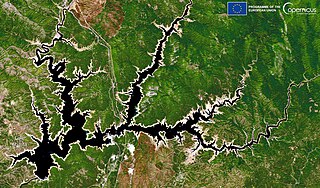
The Feather River is the principal tributary of the Sacramento River, in the Sacramento Valley of Northern California. The river's main stem is about 73 miles (117 km) long. Its length to its most distant headwater tributary is just over 210 miles (340 km). The main stem Feather River begins in Lake Oroville, where its four long tributary forks join—the South Fork, Middle Fork, North Fork, and West Branch Feather Rivers. These and other tributaries drain part of the northern Sierra Nevada, and the extreme southern Cascades, as well as a small portion of the Sacramento Valley. The total drainage basin is about 6,200 square miles (16,000 km2), with approximately 3,604 square miles (9,330 km2) above Lake Oroville.

The Caldecott Tunnel is a four-bore highway tunnel through the Berkeley Hills between Oakland and Orinda, California. Its four bores carry California State Route 24. Named after Thomas E. Caldecott, former mayor of Berkeley, it opened in 1937 as a two-bore tunnel. The third bore opened in 1964 and the fourth bore in 2013. Currently, the two oldest bores carry eastbound traffic and the two newest bores carry westbound traffic.
Shasta Lake, also popularly known as Lake Shasta, is a reservoir in Shasta County, California, United States. It began to store water in 1944 due to the impounding of the Sacramento River by Shasta Dam, the ninth tallest dam in the United States.

Montclair is a hillside neighborhood in Oakland, California, United States. Montclair is located along the western slope of the Oakland Hills from a valley formed by the Hayward Fault to the upper ridge of the hills.

Temescal Regional Recreation Area (TRRA), formerly Lake Temescal Regional Park, is a regional park in the Berkeley Hills, in northeastern Oakland, California. The TRRA encompasses 48 acres (19 ha), abutting SR 24, SR13, and the interchange connecting the two highways, southwest of the Caldecott Tunnel.The park is part of the East Bay Regional Park District (EBRPD).

Temescal is one of the oldest neighborhoods in Oakland, California, located in North Oakland, and centered on Telegraph Avenue. The neighborhood derives its name from Temescal Creek, a significant watercourse in the city.

The Berkeley Hills are a range of the Pacific Coast Ranges that overlook the northeast side of the valley that encompasses San Francisco Bay. They were previously called the "Contra Costa Range/Hills", but with the establishment of Berkeley and the University of California, the current usage was applied by geographers and gazetteers.

Temescal Creek is one of the principal watercourses in the city of Oakland, California, United States.

The Sacramento Northern Railway was a 183-mile (295 km) electric interurban railway that connected Chico in northern California with Oakland via the state capital, Sacramento. In its operation it ran directly on the streets of Oakland, Sacramento, Yuba City, Chico, and Woodland. This involved multiple car trains making sharp turns at street corners and obeying traffic signals. Once in open country, SN's passenger trains ran at fairly fast speeds. With its shorter route and lower fares, the SN provided strong competition to the Southern Pacific and Western Pacific Railroad for passenger business and freight business between those two cities. North of Sacramento, both passenger and freight business was less due to the small town agricultural nature of the region and due to competition from the paralleling Southern Pacific Railroad.

Alameda Creek is a large perennial stream in the San Francisco Bay Area. The creek runs for 45 miles (72 km) from a lake northeast of Packard Ridge to the eastern shore of San Francisco Bay by way of Niles Canyon and a flood control channel. Along its course, Alameda Creek provides wildlife habitat, water supply, a conduit for flood waters, opportunities for recreation, and a host of aesthetic and environmental values. The creek and three major reservoirs in the watershed are used as water supply by the San Francisco Public Utilities Commission, Alameda County Water District and Zone 7 Water Agency. Within the watershed can be found some of the highest peaks and tallest waterfall in the East Bay, over a dozen regional parks, and notable natural landmarks such as the cascades at Little Yosemite and the wildflower-strewn grasslands and oak savannahs of the Sunol Regional Wilderness. After an absence of half a century, ocean-run steelhead trout are able to return to Alameda Creek to mingle with remnant rainbow trout populations. Completion of a series of dam removal and fish passage projects, along with improved stream flows for cold-water fish and planned habitat restoration, enable steelhead trout and Chinook salmon to access up to 20 miles (32 km) of spawning and rearing habitat in Alameda Creek and its tributaries. The first juvenile trout migrating downstream from the upper watershed through lower Alameda Creek toward San Francisco Bay was detected and documented in April 2023.

Folsom Lake is a reservoir on the American River in the Sierra Nevada foothills of California, United States. Folsom Lake with its surrounding Folsom Lake State Recreation Area is one of the most visited parks in the California park system.
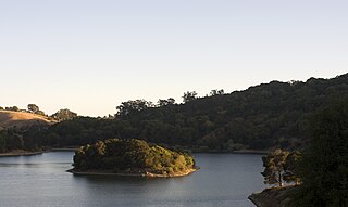
Lake Chabot is a man-made lake covering 317 acres (1.3 km2) in Alameda County, California, United States. Part of the lake lies within Oakland city limits, but most of it lies in unincorporated Castro Valley, just east of San Leandro. It was formed by the damming of San Leandro Creek. The lake was completed in 1875 to serve as a primary source of water for the East Bay.
Lake Del Valle is a storage reservoir located 10 miles (16 km) southeast of Livermore, in Alameda County, California. It is within Del Valle Regional Park.

The San Pablo Reservoir is an open cut terminal water storage reservoir owned and operated by the East Bay Municipal Utility District (EBMUD). It is located in the valley of San Pablo Creek, north of Orinda, California, United States, and south of El Sobrante and Richmond, east of the Berkeley Hills between San Pablo Ridge and Sobrante Ridge.

Shadow Cliffs Regional Recreation Area is a regional park on the border of Pleasanton and Livermore, California, that is part of the East Bay Regional Parks (EBRP) system. Its lake, once a gravel pit, has a sandy beach and is used for swimming, fishing, and recreational boating. The park once featured water slides, which were closed in 2011 and have since been taken down, and are planned to be replaced by an Interpretive Center. The park is also a popular picnic ground.
The Feather River Route is a rail line that was built and operated by the Western Pacific Railroad. It was constructed between 1906 and 1909, and connects the cities of Oakland, California, and Salt Lake City, Utah. The line was built to compete with the Central Pacific Railroad, which at the time held a nearly complete monopoly on Northern California rail service. The route derives its name from its crossing of the Sierra Nevada, where it follows both the North and Middle Forks of the Feather River. The route is famous for its impressive engineering qualities and its considerable scenic value. All of the route is now owned and operated by the Union Pacific Railroad; however, the Union Pacific has transferred significant portions of the route to other lines. The portion still called the Feather River Route by the Union Pacific runs from the California Central Valley to Winnemucca, Nevada and has been divided into three subdivisions named the Sacramento, Canyon and Winnemucca subdivisions.

Rollins Dam is a dam on the border of Nevada and Placer counties in northern California, in the United States.


