Caldecott Tunnel

Last updated
Caldecott Tunnel
Western portals of the Caldecott Tunnel, May 2019.JPG
The western end of the Caldecott Tunnel in 2019
Overview
Location Oakland / Contra Costa County, California
Coordinates 37°51′17″N122°13′00″W / 37.8548°N 122.2166°W / 37.8548; -122.2166
RouteCalifornia 24.svg SR 24 (William Byron Rumford Freeway)
Crosses Berkeley Hills
Operation
OpenedBores 1 & 2: 1937
Bore 3: 1964
Bore 4: 2013
Operator Caltrans
Technical
LengthBores 1 & 2: 3,610 ft (1,100 m)
Bore 3: 3,771 ft (1,149 m)
Bore 4: 3,389 ft (1,033 m)
No. of lanes 2 per bore
Tunnel clearance Bore 1: 14.58 feet (4.44 m)
Bore 2: 14.5 feet (4.4 m)
Bore 3: 15.5 feet (4.7 m)
Bore 4: 15.5 feet (4.7 m)
Route map
Caldecott Tunnel
Designated1980
Reference no.32

The Caldecott Tunnel is a four-bore highway tunnel through the Berkeley Hills between Oakland and Orinda, California. Its four bores carry California State Route 24. Named after Thomas E. Caldecott, former mayor of Berkeley, it opened in 1937 as a two-bore tunnel. The third bore opened in 1964 and the fourth bore in 2013. Currently, the two oldest bores carry eastbound traffic and the two newest bores carry westbound traffic.

Contents

Description

The east–west tunnel is signed as a part of California State Route 24 and connects Oakland to central Contra Costa County. It is named after Thomas E. Caldecott (1878–1951), who was mayor of Berkeley in 1930–1932, a member of the Alameda County Board of Supervisors in 1933–1945, and president of Joint Highway District 13, which built the first two bores.

Bore 1 (the southernmost bore) and Bore 2 were completed in 1937; they are 3,610 ft (1,100 m) in length and today carry two lanes each of eastbound traffic. Bore 3, completed in 1964, is 3,771 ft (1,149 m) in length. Bore 4 (the northernmost bore), completed in 2013, is 3,389 ft (1,033 m) in length. Bores 3 and 4 carry two lanes each of westbound traffic.

The active Hayward Fault runs just west of the western portals of the tunnel. [1]

History

Traffic patterns in 1937 Caldecott Tunnel Twin Bores.jpg
Traffic patterns in 1937

In the 19th century, traffic over the Berkeley Hills in this area went up Harwood Canyon, now known as Claremont Canyon (behind the Claremont Hotel). The road leading up the canyon from the west was initially called Harwood's Road, later changed to Telegraph Road, and finally, Claremont. The road on the other side of the hills became known as Fish Ranch Road, its current name, some time after 1870, the year the Oakland Trout Company incorporated its fish and frog farm in the vicinity. [2] An inn and stage coach stop called the Summit House once existed at the summit.

The idea of a tunnel through the hills began as early as 1860. In that year, the idea was proposed and rejected by the citizens of Alameda and Contra Costa Counties. It was revived in 1871 in a private attempt led by L.W. Kennedy which however failed after boring about 200 feet into the hills from the east side of the hills above the location of today's Caldecott Tunnel when water was struck, washing out the work. Bankruptcy followed and the effort, which came to be known as the "old Kennedy tunnel" was abandoned. A franchise was subsequently granted to a group of developers who passed the franchise onto another group. The proposal languished until the turn of the century. [3] [4]

Just before the end of the 19th century, the tunnel idea was revived and discussed by business and government representatives of Contra Costa and Alameda Counties. [5] These discussions led to a new tunnel construction project at the approximate location of the old Kennedy tunnel attempt. The work on the Contra Costa side proceeded based on the old tunnel alignment while work on the Alameda County side started from the top of Temescal Canyon. On the west side, the project involved the construction of a proper approach road. The new road, dubbed "Tunnel Road", was built from the top of Russell Street in Berkeley (later realigned with Ashby Avenue) at the foot of Claremont Canyon and ran around the spur separating that canyon from Temescal Canyon, climbing along the slope of the spur to the summit of the Berkeley Hills until it reached the west portal of the new tunnel. [6] The west end of the tunnel was at about 37°51′22″N122°12′49″W / 37.8561°N 122.2137°W / 37.8561; -122.2137 while the east end of the tunnel is now in private property owned by the East Bay Regional Park District, on the former site of the Canary Cafe. The tunnel was dedicated on November 4, 1903 as the "Inter-County Tunnel". [7] A system of lighting a small fire with a newspaper was used to control this one-way traffic. The tunnel height was increased in 1915 by 3 feet to accommodate larger vehicles. [8] After the new Broadway (Caldecott) tunnel was opened at the end of 1937, the old tunnel was used mostly by pedestrians until it was sealed in 1947. [9]

Original twin bores

In November 1926, the Counties of Alameda and Contra Costa, and the City of Oakland agreed to the construction of a new tunnel through the Berkeley Hills to replace the old, small, decrepit and increasingly inadequate existing tunnel. [10] In 1929, Alameda and Contra Costa County formed Joint Highway District 13 to accomplish this goal. [11] Surveys and preliminary work on the approaches began in 1931. [12] [13]

On June 17, 1934, construction of the first two bores of the Caldecott Tunnel began. [14]

The project included an extension of Broadway from its existing termination point below the hills some two miles from the planned west portal of the new tunnel. This required some major earth-moving efforts, both cutting and filling as well as buttressing, especially up in Temescal Canyon. This included filling in one of the inlets of Lake Temescal as well as part of the upper canyon where Broadway was to run.

The entire project was completed in 1937, and the tunnel opened to traffic on December 5 of that year. [15] The tunnel was named the Broadway Low Level Tunnel (commonly shortened to Broadway Tunnel), since the principal through access was from Broadway in Oakland, and was located below the portal of the old Inter County Tunnel. However, access from Ashby Avenue was retained as it was designated the connecting thoroughfare from the Eastshore Highway (re-engineered as a freeway in the mid 1950s) and the new San Francisco–Oakland Bay Bridge, and dubbed State Highway 24. The approach to the east portal on the other side of the Berkeley Hills was via Mount Diablo Boulevard, also at that time part of State Highway 24.

In 1960, the Broadway Low Level Tunnel was renamed, becoming the Caldecott Tunnel. [16]

Third bore and traffic reversal

The Caldecott Tunnel prior to the construction of the fourth bore as seen from the western end. From left to right: Bores 3, 2, and 1. Caldecott Tunnel.jpg
The Caldecott Tunnel prior to the construction of the fourth bore as seen from the western end. From left to right: Bores 3, 2, and 1.

By 1960, the Division of Highways had rebuilt the eastern approach to the tunnel into a freeway. With Contra Costa County accessible by freeway, its change from an agricultural community into a major suburb accelerated.

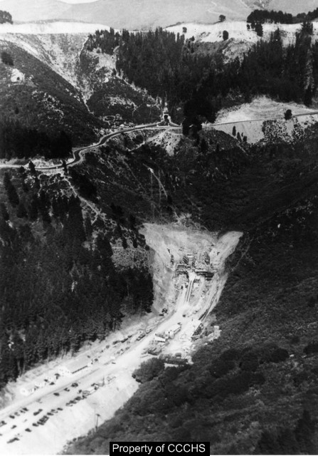
The Division of Highways purchased sufficient right-of-way to the north of the existing twin bores to build another pair of bores. Given the traffic counts and the expense of tunnel construction, the construction of two additional bores would have been seen as unnecessary and extravagant. However, with the traffic count exceeding 50,000 vehicles per day, the state embarked on a project to build a third bore at the Caldecott Tunnel. [17]

The project broke ground in 1960 and was opened to traffic in October 1964. When the third bore was opened, the other bores were closed one at a time for maintenance, including the installation of a continuous row of fluorescent lights. Eventually the new third bore made it possible to reverse the traffic flow of the middle bore, providing four lanes to accommodate the heavier commute-direction traffic.

The third bore also brought new technology to the tunnel with the installation of the "pop-up" lane control. Plastic lane delineators were set in tubes within the pavement. With the touch of a button, water would fill tubes to cause the delineators to pop up from the pavement; the middle bore was closed to one direction of travel, while opening it to another. During the week, the middle bore of the Caldecott was reversed between 2:00 am and 5:00 am to favor westbound traffic, and then switched again sometime between 11:30 am and noon to favor eastbound traffic. Ballgames, concerts and other events made balancing weekend traffic through the tunnel very difficult. It was not uncommon to reverse the middle bore six times on a Saturday or Sunday. The pop-up system still required substantial manpower to implement. While it did eliminate the need to set down individual cones to separate traffic, Caltrans maintenance workers had to direct traffic out of the closing lanes to prevent vehicles from getting caught on the wrong side of the pop-up delineators. [18]

A portion of the material excavated for the third bore was used in the construction of embankments for the MacArthur Freeway project between the MacArthur Maze and Broadway in Oakland. [19]

In the late 1960s, the Grove-Shafter Freeway was completed and replaced Broadway as the main route to the Caldecott Tunnel from Oakland as well as replacing Ashby for traffic coming from San Francisco. Ashby Avenue and Tunnel Road were redesignated State Highway 13 and aligned with the new Warren Freeway through the Montclair District of Oakland. The Grove-Shafter Freeway was then designated State Highway 24. In 1980, the freeway was renamed after William Byron Rumford.

Tunnel fire

On April 7, 1982, an accident involving a gasoline tanker truck in the third (then-northernmost) bore set off the Caldecott Tunnel fire. [20] The accident caused major damage and the bore was closed to traffic for several months while repairs were made, with traffic temporarily reverting to the pre-third-bore configuration. During the fire, the tunnel acted as a natural chimney, venting the smoke, flames and heat uphill towards the eastern entrance to the tunnel. The accident and fire killed seven people, most of whom were overcome by toxic smoke. The fire occurred shortly after midnight when there were few cars in the tunnel; had it occurred during normal commute hours, hundreds could have died. As a result of the fire, it is now illegal to transport hazardous material in a tanker truck through the tunnel, except between the light-traffic hours of 3:00 am and 5:00 am. [21]

Oakland firestorm

On October 20, 1991, the catastrophic Oakland firestorm started on the ridge north of the Caldecott Tunnel. The fire spread quickly west down both sides of the west portal of the tunnel and jumped the freeway, eventually killing 25 people and destroying over 3,000 homes, apartments and condominiums.

Awards

The Caldecott Tunnel was designated a City of Oakland Landmark in 1980, and received a Preservation Award from the Art Deco Society of California in 1993.

Fourth bore

To relieve traffic congestion in the reverse commute direction, the California Department of Transportation began planning for a fourth bore in 2000. In 2007, the California Transportation Commission approved the final funding needed to build the fourth bore. [22] Construction started in 2010. [23] Commencement of the project was stalled as a result of the financial crisis of 2007–2008, but was quickly back on track as a beneficiary of President Obama's American Recovery and Reinvestment Act of 2009 (ARRA). [24] [25] Construction got underway until completion in 2013. [26] [27] [28] Much of the excavated material from the bore was trucked to Treasure Island for use in soil augmentation and remediation during the subsequent redevelopment of the island. [29]

The fourth bore contains a roadway with two 12-foot-wide (3.7 m) traffic lanes, one 10-foot-wide (3.0 m) shoulder, and one 2-foot-wide (0.6 m) shoulder, [30] ventilation, air and traffic monitoring systems, traffic lights, and electronic message boards. [31] There are emergency exits to the third bore. When the fourth bore was opened to traffic, the need for the daily traffic reversal was eliminated; two bores (four lanes) serve each direction at all times, although individual bores may be closed during periods of light use for maintenance purposes. [32]

Weather phenomena

Weather conditions can vary greatly from one end of the tunnel to the other. In summer, for example, motorists may enter the tunnel from the east where it is sunny and warm, and emerge on the west end into fog and cold. In winter, during spells of inland tule fog, the reverse can occur. [33] [34]

See also

Related Research Articles

<span class="mw-page-title-main">San Francisco–Oakland Bay Bridge</span> Complex of bridges spanning San Francisco Bay

The San Francisco–Oakland Bay Bridge, known locally as the Bay Bridge, is a complex of bridges spanning San Francisco Bay in California. As part of Interstate 80 and the direct road between San Francisco and Oakland, it carries about 260,000 vehicles a day on its two decks. It includes one of the longest bridge spans in the United States.

<span class="mw-page-title-main">Interstate 580 (California)</span> Interstate highway in California

Interstate 580 (I-580) is an approximately 76-mile-long (122 km) east–west auxiliary Interstate Highway in Northern California. The heavily traveled spur route of I-80 runs from US Route 101 (US 101) in San Rafael in the San Francisco Bay Area to I-5 at a point outside the southern city limits of Tracy in the Central Valley. I-580 forms a concurrency with I-80 between Albany and Oakland, the latter of which is the location of the MacArthur Maze interchange immediately east of the San Francisco–Oakland Bay Bridge. I-580 provides a connection from the Bay Area to the southern San Joaquin Valley and Southern California via I-5, as I-5 bypasses the Bay Area to the east.

<span class="mw-page-title-main">Interstate 680 (California)</span> Interstate highway in California

Interstate 680 (I-680) is a north–south auxiliary Interstate Highway in Northern California. It curves around the eastern cities of the San Francisco Bay Area from San Jose to I-80 at Fairfield, bypassing cities along the eastern shore of San Francisco Bay such as Oakland and Richmond while serving others more inland such as Pleasanton and Concord.

<span class="mw-page-title-main">California State Route 13</span> State highway in Alameda County, California, United States

State Route 13 is a state highway in the U.S. state of California. It runs entirely in Alameda County, connecting Interstate 580 in Oakland to Interstate 80/Interstate 580 in Berkeley.

<span class="mw-page-title-main">California State Route 24</span> Highway in California

State Route 24 is a heavily traveled east–west state highway in the U.S. state of California that serves the eastern side of the San Francisco Bay Area. A freeway throughout its entire length, it runs from the Interstate 580/Interstate 980 interchange in Oakland, and through the Caldecott Tunnel under the Berkeley Hills, to the Interstate 680 junction in Walnut Creek. It lies in Alameda County, where it is highly urban, and Contra Costa County, where it passes through wooded hillsides and suburbs. SR 24 is a major connection between the San Francisco–Oakland Bay Bridge/MacArthur Maze complex and the inland cities of the East Bay.

<span class="mw-page-title-main">Richmond–San Rafael Bridge</span> Bridge crossing the San Francisco Bay

The Richmond–San Rafael Bridge is the northernmost of the east–west crossings of California's San Francisco Bay, carrying Interstate 580 from Richmond on the east to San Rafael on the west. It opened in 1956, replacing ferry service by the Richmond–San Rafael Ferry Company, and was officially renamed in 1981 to honor California State Senator John F. McCarthy, who championed the bridge's creation.

<span class="mw-page-title-main">Telegraph Avenue</span> Street in Oakland and Berkeley, California

Telegraph Avenue is a street that begins, at its southernmost point, in the midst of the historic downtown district of Oakland, California, and ends, at its northernmost point, at the southern edge of the University of California, Berkeley campus in Berkeley, California. It is approximately 4.5 miles (7.2 km) in length.

Canyon, formerly known as Sequoya, is an unincorporated community located near the border of Contra Costa and Alameda counties, in the U.S. state of California. It is situated between Oakland and Moraga in the San Francisco Bay Area. The community is named for its location in the upper canyon of San Leandro Creek along the eastern slope of the Berkeley Hills. Canyon lies at an elevation of 1138 feet.

Lamorinda is an area within Contra Costa County, California in the United States. The name is a portmanteau from the names of the three cities that make up the region: Lafayette, Moraga and Orinda.

<span class="mw-page-title-main">East Bay</span> Eastern region of the San Francisco Bay Area, California, US

The East Bay is the eastern region of the San Francisco Bay Area and includes cities along the eastern shores of the San Francisco Bay and San Pablo Bay. The region has grown to include inland communities in Alameda and Contra Costa counties. With a population of roughly 2.5 million in 2010, it is the most populous subregion in the Bay Area.

<span class="mw-page-title-main">MacArthur Maze</span> Freeway interchange in California

The MacArthur Maze is a large freeway interchange near the east end of the San Francisco–Oakland Bay Bridge in Oakland, California. It splits Bay Bridge traffic into three freeways—the Eastshore (I-80/I-580), MacArthur (I-580) and Nimitz (I-880).

<span class="mw-page-title-main">Montclair, Oakland, California</span> Neighborhood of Oakland in Alameda, California, United States

Montclair is a hillside neighborhood in Oakland, California, United States. Montclair is located along the western slope of the Oakland Hills from a valley formed by the Hayward Fault to the upper ridge of the hills.

<span class="mw-page-title-main">Lake Temescal</span> Lake in California, USA

Lake Temescal is a small reservoir in the Oakland hills, in northeastern Oakland, California. It is the centerpiece of Temescal Regional Recreation Area, also known as Temescal Regional Park. It is a part of the East Bay Regional Park District.

<span class="mw-page-title-main">Berkeley Hills</span> Region of the Pacific Coast Ranges

The Berkeley Hills are a range of the Pacific Coast Ranges that overlook the northeast side of the valley that encompasses San Francisco Bay. They were previously called the "Contra Costa Range/Hills", but with the establishment of Berkeley and the University of California, the current usage was applied by geographers and gazetteers.

<span class="mw-page-title-main">Temescal Creek (Northern California)</span> River in California, United States

Temescal Creek is one of the principal watercourses in the city of Oakland, California, United States.

<span class="mw-page-title-main">Claremont, Oakland/Berkeley, California</span> Place in California, United States

The Claremont district is a neighborhood straddling the city limits of Oakland and Berkeley in the East Bay section of the San Francisco Bay Area in California, United States. The main thoroughfares are Claremont and Ashby Avenues.

Thomas Edwin Caldecott was a pharmacist and politician. From 1923, Caldecott served in politics in Alameda County, California in the San Francisco Bay Area until 1951. The Caldecott Tunnel which is a key highway link through the Berkeley Hills is named after him.

The Posey and Webster Street Tubes are two parallel underwater tunnels connecting the cities of Oakland and Alameda, California, running beneath the Oakland Estuary. Both are immersed tubes, constructed by sinking precast concrete segments to a trench in the Estuary floor, then sealing them together to create a tunnel. The Posey Tube, completed in 1928, currently carries one-way (Oakland-bound) traffic under the Estuary, while the Webster Street Tube, completed in 1963, carries traffic from Oakland to Alameda.

<span class="mw-page-title-main">Southern Crossing (California)</span> Proposed fixed link across the San Francisco Bay

The Southern Crossing is a proposed highway structure that would span San Francisco Bay in California, somewhere south of the San Francisco–Oakland Bay Bridge and north of the San Mateo–Hayward Bridge. Several proposals have been made since 1947, varying in design and specific location, but none of them have ever been implemented because of cost, environmental and other concerns.

References

  1. "Digital Map of Recently Active Traces of the Hayward Fault, California". earthquake.usgs.gov. US Geological Survey. Retrieved November 26, 2016.
  2. Sacramento Daily Union, 2 January 1871, p.2
  3. History of Contra Costa County, California. W.A. Slocum and Company. 1882. p.  135.
  4. "Old Road That Ruined Three Pioneers To Be Completed", San Francisco Call, November 14, 1902, p.9
  5. "The Work Begun", Oakland Tribune, May 24, 1897
  6. "Work of Supervisors on Inter-County Road", Oakland Tribune, 04 Nov 1903, Page 3
  7. San Francisco Call, Volume 94, Number 158, 5 November 1903
  8. "Lafayette: A Pictorial History". Lafayette Historical Society. Archived from the original on September 28, 2013. Retrieved October 8, 2013.
  9. Rafkin, Louise (October 1, 2011). "Local Intelligence: Kennedy Tunnel". Bay Citizen. Archived from the original on January 3, 2012. Retrieved October 8, 2013.
  10. California Highways and Public Works, Official Journal of the Division of Highways, Department of Public Works, State of California, May, 1934, p.16
  11. California Highways and Public Works, Official Journal of the Division of Highways, Department of Public Works, State of California, Jul-August, 1960, p.31
  12. California Highways and Public Works, Official Journal of the Division of Highways, Department of Public Works, State of California, December, 1937, p.12
  13. California Highways and Public Works, Official Journal of the Division of Highways, Department of Public Works, State of California, May, 1934, p.15
  14. California Highways and Public Works, Official Journal of the Division of Highways, Department of Public Works, State of California, July, 1934, p.16
  15. California Highways and Public Works, Official Journal of the Division of Highways, Department of Public Works, State of California, December, 1937, p.4
  16. California Highways and Public Works, Official Journal of the Division of Highways, Department of Public Works, State of California, Vol.39, Nos.9-10, September-October, 1960, p.60
  17. California Highways and Public Works, Official Journal of the Division of Highways, Department of Public Works, State of California, Vol.39, Nos.7-8, July-August, 1960, p.31
  18. "History of the Caldecott". The Caldecott Tunnel Fourth Bore Project. Archived from the original on February 2, 2014. Retrieved October 8, 2013.
  19. California Highways and Public Works, March-April, 1960, p.9
  20. Martin, Murilee (April 16, 2007). "25 Years Since The Great Caldecott Tunnel Fire". Jalopnik. Retrieved January 23, 2010.
  21. "Vehicle Code Section 31301 - Caldecott Tunnel Restriction". California Department of Motor Vehicles. September 20, 1982. Retrieved January 23, 2010.
  22. "Corridor Mobility Improvement Account (CMIA) as adopted by California Transportation Commission (CTC) — February 28, 2007: San Francisco Bay Area Projects" (PDF). Metropolitan Transportation Commission. Archived from the original (PDF) on January 23, 2014. Retrieved January 20, 2014.
  23. Cabanatuan, Michael (January 23, 2010). "Work begins on Caldecott Tunnel's 4th bore". San Francisco Chronicle. Retrieved January 20, 2014.
  24. "Tunneling Begins on $420 Million Caldecott Tunnel Fourth Bore Project | Metropolitan Transportation Commission".
  25. "Press Release: Recovery Act-Funded Excavation Begins on Caldecott Tunnel's Fourth Bore, 8/9/2010 | Press Releases | Federal Highway Administration".
  26. Cabanatuan, Michael (December 1, 2011). "Breakthrough for Caldecott Tunnel's new 4th bore". San Francisco Chronicle. Retrieved January 20, 2014.
  27. Cabanatuan, Michael (August 13, 2012). "Caldecott tunnel excavation completed". San Francisco Chronicle. Retrieved October 8, 2013.
  28. Cabanatuan, Michael (November 16, 2013). "Caldecott Tunnel fourth bore opens". San Francisco Chronicle. Retrieved January 20, 2014.
  29. Cuff, Denis (November 13, 2013). "Caldecott Tunnel forth bore to ease traffic backups during reverse commute". Mercury News. Retrieved December 29, 2018.
  30. "Project Fact Sheet" (PDF). mtc.ca.gov. April 2010. Retrieved December 4, 2021.
  31. Cardno, Catherine A. (February 2014). "Safe passage". Civil Engineering. American Society of Civil Engineers: 60–65.
  32. "Caldecott Tunnel Fourth Bore Project Schedule". The Caldecott Tunnel Fourth Bore Project. Archived from the original on February 2, 2014. Retrieved October 8, 2013.
  33. "Oakland Beautiful Point Of Interest: Caldecott Tunnel", Eric Saltmarsh, March 10, 2015, Keep Oakland Beautiful, Keep America Beautiful Affiliate". Archived from the original on November 26, 2016. Retrieved November 26, 2016.
  34. Weather of the San Francisco Bay Area, by Harold Gilliam, University of California Press, 1962

37°51′17″N122°13′00″W / 37.8548°N 122.2166°W / 37.8548; -122.2166