Stockton Street Tunnel

Last updated

Stockton Street Tunnel
Stockton Street Tunnel, San Francisco (2939103825).jpg
Overview
Location Nob Hill, San Francisco, California
Coordinates 37°47′29″N122°24′27″W / 37.7915°N 122.4074°W / 37.7915; -122.4074
Route Stockton Street
StartJust to the south of Bush Street
EndJust to the south of Sacramento Street
Operation
OpenedDecember 29, 1914
OwnerCity of San Francisco
OperatorCity of San Francisco
TrafficAutomotive and pedestrian
Technical
Length911 feet (278 m)
No. of lanes 3
Electrified 600 V DC parallel overhead lines (Muni Trolleybus)
Tunnel clearance 13 feet (4 m)
Width50 feet (15 m)
Route map
Stockton Street Tunnel

The Stockton Street Tunnel is a tunnel in San Francisco, California, which carries its namesake street underneath a section of Nob Hill near Chinatown for about three blocks. It was opened in 1914. The south portal is located just shy of Bush Street, which is about two blocks to the north of Union Square. The north portal is located just to the south of the Sacramento Street intersection.

Contents

Design

The tunnel was built to decrease the grade through the hill. Before the tunnel was built, the maximum grade along the route of Stockton Street north from its intersection with Sutter was 18% and the maximum grade south from the intersection with Sacramento was 12%. The tunnel was built with a maximum grade of 4.29% between Sacramento and Sutter. [1] Initial plans in 1909 called for a tunnel 1,400 feet (430 m) long. [2] The planned tunnel was shortened in 1910 to 750 feet (230 m), with a width of 55 feet (17 m) and a height of 25 feet (7.6 m), with stairways to connect the tunnel with Pine and California streets. [3] The bore was narrowed slightly in 1912, with a total planned width of 42 feet (13 m) and a height of 18 feet (5.5 m). [4]

Construction involved lowering Stockton Street near where it passes into the tunnel from the south, evidence for which can still be seen at the building of 417 Stockton Street (Mystic Hotel), where the basement became the ground floor and the former front door is now a visibly marked window bay on the second floor. [5]

History

The tunnel was primarily built for the streetcars of the now defunct F Stockton line. [6] A petition was filed for a new streetcar line by Frank Stringham, representing an unnamed group of investors, with the San Francisco Board of Supervisors on January 23, 1909. Their intent was to create a nearly level route connecting North Beach with the downtown area. [2] George Skaller later took credit for the initial push for a tunnel, saying that the city had studied the idea for at least 20 years, but would never be built as "all city enterprises, on account of the long and windy red tape connected with city enterprises" were doomed by bureaucracy. [7] Stockton was favored over Grant, which was seen as too narrow, or Kearny, which already was franchised to the United Railways. [7]

Although Skaller initially hoped to raise private funding for the tunnel, the Board of Supervisors imposed a requirement allowing the city to take over the railway after ten years at its physical valuation, and no private investors were willing to fund the project. Instead, Skaller turned to the idea of public funding through a special assessment district, labeling the project as an "improvement" for existing roads. [7] The Stockton Street Tunnel Association launched its fundraising campaign in May 1910, hoping to raise $450,000 (equivalent to $10.3 million in 2022 [8] ) to cover construction costs by creating a special assessment district to fund the improvements. The estimated assessment for a lot 25 by 100 feet (7.6 by 30.5 m) was $62.50 (equivalent to $1,963 in 2022 [9] ) in 1910. [3] The project adopted the slogan "The open door to North Beach" in May 1910. [10]

The Stockton Street Railway franchise was relinquished to the city in 1910, and suggestions were made that if ferries from Marin would land in North Beach instead of the Ferry Building, the resulting rise in local property values would offset the cost of the assessment. [11] Two assessment districts were set up, in North Beach and Downtown, and projected traffic was estimated to reach 50,000 to 75,000 passengers per hour during the Panama–Pacific International Exposition of 1915. The precedent set by the assessment districts for the Stockton Street Tunnel sparked interest in building a similar tunnel under Fillmore Street and leveling Rincon Hill to increase usable land, [12] but these added works were not carried through.

Final plans for the tunnel were filed by city engineer Marsden Manson in March 1912. [4] By June 1912, the final legal and funding issues were being resolved, and work was to start "within 30 or 60 days." [13] In July 1913, excavation of the bore was planned to take 100 days. [14] During construction, hotel guests were kept awake by work at night [15] and at least one worker was killed by a cave-in. [16] Revenue service through the tunnel was inaugurated by Mayor James Rolph on December 29, 1914. [5]

Streetcar service through the tunnel ended on January 20, 1951, [17] and was re-designated as route 30. [18] Tracks were removed, but electrified overhead wires were retained for trolleybus service.

In 1984, prodded by Chinatown advocates, San Francisco added safety rails for the sidewalk, new lighting, and waterproofing, after a pedestrian was killed by an automobile. [19]

In media

SFGATE has remarked on the tunnel's use by filmmakers, noting in particular the "crooked" topography at its southern end at Bush and Stockton streets: "Many dimensions are blurred on the cryptic intersection. [...] The Escher-like dimensions mark the edge of four different neighborhoods. Steep alleys appear from nowhere and plunge onto the sidewalk." [20]

See also

Related Research Articles

<span class="mw-page-title-main">San Francisco Municipal Railway</span> Public transport agency in San Francisco, California, USA

The San Francisco Municipal Railway ( MEW-nee; SF Muni or Muni), is the primary public transit system within San Francisco, California. It operates a system of bus routes, the Muni Metro light rail system, three historic cable car lines, and two historic streetcar lines. Previously an independent agency, the San Francisco Municipal Railway merged with two other agencies in 1999 to become the San Francisco Municipal Transportation Agency (SFMTA). In 2018, Muni served 46.7 square miles (121 km2) with an operating budget of about $1.2 billion. Muni is the seventh-highest-ridership transit system in the United States, with 114,721,200 rides in 2022, and the second-highest in California after the Los Angeles County Metropolitan Transportation Authority.

<span class="mw-page-title-main">Muni Metro</span> Light rail system in San Francisco

Muni Metro is a semi-metro system serving San Francisco, California, United States. Operated by the San Francisco Municipal Railway (Muni), a part of the San Francisco Municipal Transportation Agency (SFMTA), Muni Metro served an average of 68,700 passengers per weekday in the first quarter of 2023, making it the seventh-busiest light rail system in the United States.

<span class="mw-page-title-main">N Judah</span> San Francisco light rail line

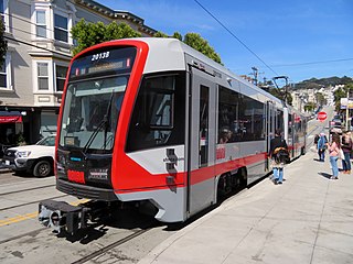
The N Judah is a hybrid light rail/streetcar line of the Muni Metro system in San Francisco, California. The line is named after Judah Street that it runs along for much of its length, named after railroad engineer Theodore Judah. It links downtown San Francisco to the Cole Valley and Sunset neighborhoods. The line provides rail access to Golden Gate Park. It is the busiest line in the Muni Metro system, serving an average of 41,439 weekday passengers in 2013. It was one of San Francisco's streetcar lines, beginning operation in 1928, and was partially converted to modern light-rail operation with the opening of the Muni Metro system in 1980. While many streetcar lines were converted to bus lines after World War II, the N Judah remained a streetcar line due to its use of the Sunset Tunnel.

<span class="mw-page-title-main">Sunset Tunnel</span> Streetcar tunnel in San Francisco, California, U.S.

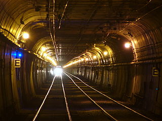
The Sunset Tunnel, originally known as the Duboce Tunnel, is a 4,232 ft (1,290 m)-long light rail/streetcar tunnel in San Francisco, California. The tunnel runs under the steep hill adjacent to Buena Vista Park and is used exclusively by the N Judah Muni Metro line.

<span class="mw-page-title-main">Central Subway (San Francisco)</span> Underground light rail line

The Central Subway is a Muni Metro light rail tunnel in San Francisco, California, United States. It runs between Chinatown station in Chinatown and a portal in South of Market (SoMa), with intermediate stops at Union Square/Market Street station in Union Square and Yerba Buena/Moscone station in SoMa. A surface portion runs through SoMa to connect to the previously existing T Third Street line at 4th and King station.

<span class="mw-page-title-main">Twin Peaks Tunnel</span> Light rail tunnel in San Francisco, California

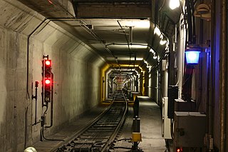
The Twin Peaks Tunnel is a 2.27-mile-long (3.65 km) light rail/streetcar tunnel in San Francisco, California. The tunnel runs under Twin Peaks and is used by the K Ingleside, M Ocean View and S Shuttle lines of the Muni Metro system.

<span class="mw-page-title-main">Market Street subway</span> BART-Muni Metro main line, San Francisco

The Market Street subway is a two-level subway tunnel that carries Muni Metro and BART trains under Market Street in San Francisco, California. It runs under the length of Market Street between Embarcadero station and Castro station. The upper level is used by Muni Metro lines and the lower level is used by BART lines. BART does not run through the whole subway; it turns south and runs under Mission Street southwest of Civic Center/UN Plaza station. The northeastern end of the BART level is connected to the Transbay Tube. On the Muni Metro level, the southwestern end of the Market Street subway connects to the much-older Twin Peaks Tunnel, and the northeastern end connects to surface tracks along the Embarcadero.

<span class="mw-page-title-main">California State Route 480</span> Former highway in California

State Route 480 was a state highway in San Francisco, California, United States, consisting of the elevated double-decker Embarcadero Freeway, the partly elevated Doyle Drive approach to the Golden Gate Bridge and the proposed and unbuilt section in between. The unbuilt section from Doyle Drive to Van Ness Avenue was to have been called the Golden Gate Freeway and the Embarcadero Freeway as originally planned would have extended from Van Ness along the north side of Bay Street and then along the Embarcadero to the San Francisco-Oakland Bay Bridge.

<span class="mw-page-title-main">Geary Boulevard</span> Thoroughfare in San Francisco, United States

Geary Boulevard is a major east–west 5.8-mile-long (9 km) thoroughfare in San Francisco, California, United States, beginning downtown at Market Street near Market Street's intersection with Kearny Street, and running westbound through downtown, the Civic Center area, the Western Addition, and running for most of its length through the predominantly residential Richmond District. Geary Boulevard terminates near Sutro Heights Park at 48th Avenue, close to the Cliff House above Ocean Beach at the Pacific Ocean. At 42nd Avenue, Geary intersects with Point Lobos Avenue, which takes through traffic to the Cliff House, Ocean Beach and the Great Highway. It is a major commercial artery through the Richmond District; it is lined with stores and restaurants, many of them catering to the various immigrant groups who live in the area. The boulevard borders Japantown between Fillmore and Laguna Streets.

<span class="mw-page-title-main">Balboa Park station</span> Transit station in San Francisco, California, US

Balboa Park station is a Bay Area Rapid Transit (BART) station and Muni Metro complex in the Mission Terrace neighborhood of San Francisco, California, located near the eponymous Balboa Park. It is an intermodal hub served by four BART routes, three Muni Metro lines, and a number of Muni bus routes. The station complex also includes two rail yards, Cameron Beach Yard and Green Light Rail Center, where Muni maintains Muni Metro trains and heritage streetcars. BART uses a below-grade island platform on the west side of the complex; Muni Metro routes use several smaller side platforms located on surface-level rail loops around the yards.

<span class="mw-page-title-main">T Third Street</span> San Francisco light rail line

The T Third Street is a Muni Metro light rail line in San Francisco, California. It runs along the east side of San Francisco from Sunnydale to Chinatown, traveling in the median of Third Street for most of its length before entering the Central Subway as it approaches downtown. The line serves 22 stations, all of which are accessible. Most of the surface portion of the line runs in dedicated median lanes, though two portions operate in mixed traffic.

<span class="mw-page-title-main">E Embarcadero</span> San Francisco heritage streetcar line

The E Embarcadero is a historic streetcar line that is the San Francisco Municipal Railway's second heritage streetcar line in San Francisco, California. Trial service first ran during the Sunday Streets events on The Embarcadero in 2008. The line initially ran on weekends only, but expanded to weeklong service in late April 2016.

<span class="mw-page-title-main">San Francisco 4th and King Street station</span> Train station in San Francisco, California, U.S.

San Francisco 4th and King Street station, also known as the Caltrain Depot, is a train station in the SoMa district of San Francisco, California. It is presently the northern terminus of the Caltrain commuter rail line serving the San Francisco Peninsula and Santa Clara Valley. It is also the eastern terminus of the N Judah and E Embarcadero, as well as a stop along the T Third Street of the Muni network. The station is additionally the projected terminus for the first phase of the California High-Speed Rail project and a station once Phase 2 is completed.

<span class="mw-page-title-main">Stockton Street (San Francisco)</span> Street in San Francisco, California, US

Stockton Street is a north-south street in San Francisco. It begins at Market Street passing Union Square, a major shopping district in the city. It then runs underground for about two and a half blocks in the Stockton Street Tunnel, passes through Chinatown and North Beach, and ends at Beach Street near the Pier 39 shopping center and tourist attraction.

<span class="mw-page-title-main">San Francisco Municipal Railway fleet</span> LRV and Bus Fleet of the San Francisco Municipal Railway (Muni)

With five different modes of transport, the San Francisco Municipal Railway runs one of the most diverse fleets of vehicles in the United States. Roughly 550 diesel-electric hybrid buses, 300 electric trolleybuses, 250 modern light rail vehicles, 50 historic streetcars and 40 cable cars see active duty.

<span class="mw-page-title-main">Fillmore Street Tunnel</span> Proposed San Francisco streetcar tunnel

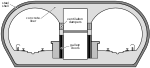
The Fillmore Street Tunnel was a proposed double-bore tunnel approximately 34 mile (1.2 km) long in San Francisco, California which would have carried Fillmore Street and a new streetcar line underneath Pacific Heights and Russian Hill. The proposed tunnel would have connected the Western Addition and Fillmore Districts, near the south portal at Sutter Street, with Marina and Cow Hollow, near the north portal at Filbert Street. One tunnel would have been reserved for railroad and pedestrian traffic, while the parallel tunnel would have been for vehicles. The tunnel was planned, along with the contemporary Twin Peaks and Stockton Street Tunnels, to serve the traffic that was anticipated from the 1914–15 Panama–Pacific International Exposition.

<span class="mw-page-title-main">30 Stockton</span> Trolleybus route in San Francisco, California

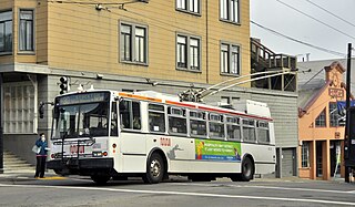
30 Stockton is a trolleybus line operated by the San Francisco Municipal Railway. The line is notable for being the slowest trolleybus route in the city of San Francisco because it travels through the densely populated neighborhood of Chinatown.

41 Union is a trolleybus line operated by the San Francisco Municipal Railway (Muni). It connects South of Market, the Financial District, Chinatown, North Beach, Russian Hill, and Cow Hollow.

<span class="mw-page-title-main">45 Union/Stockton</span>

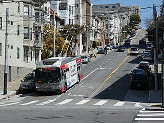
45 Union/Stockton is a trolleybus line operated by the San Francisco Municipal Railway. It connects Cow Hollow to South of Market via Russian Hill, Chinatown, and the Financial District.

References

  1. Tilton, E. G. (February 3, 1915). "Method of Constructing Rock Tunnel of 50-Ft. Clear Width, Stockton St., San Francisco". Engineering & Contracting. Vol. 43, no. 5. pp. 93–96. Retrieved September 4, 2010.
  2. 1 2 "Petition for New Franchise Filed". San Francisco Call. January 24, 1909. Retrieved September 23, 2017.
  3. 1 2 "Tunnel Project Rapidly Nears Actual Digging". San Francisco Call. May 13, 1910. Retrieved September 23, 2017.
  4. 1 2 "Classic Style Gives Pleasing Appearance to Subway Entrances". San Francisco Call. March 30, 1912. Retrieved September 23, 2017.
  5. 1 2 King, John (December 21, 2014). "Cityscape: How the Stockton Tunnel made a basement shine". San Francisco Chronicle.
  6. "A Brief History of the F-Market & Wharves Line". Market Street Railway. Retrieved February 22, 2016.
  7. 1 2 3 Skaller, George (August 10, 1912). "Subway Enterprise Is Now Well Started". San Francisco Call. Retrieved September 23, 2017.
  8. Johnston, Louis; Williamson, Samuel H. (2023). "What Was the U.S. GDP Then?". MeasuringWorth. Retrieved November 30, 2023. United States Gross Domestic Product deflator figures follow the Measuring Worth series.
  9. 1634–1699: McCusker, J. J. (1997). How Much Is That in Real Money? A Historical Price Index for Use as a Deflator of Money Values in the Economy of the United States: Addenda et Corrigenda (PDF). American Antiquarian Society. 1700–1799: McCusker, J. J. (1992). How Much Is That in Real Money? A Historical Price Index for Use as a Deflator of Money Values in the Economy of the United States (PDF). American Antiquarian Society. 1800–present: Federal Reserve Bank of Minneapolis. "Consumer Price Index (estimate) 1800–" . Retrieved May 28, 2023.
  10. "'Open Door To North Beach' Is The Slogan That Wins". San Francisco Call. May 14, 1910. Retrieved September 23, 2017.
  11. "Test Case to Fix Tunnel's Legal Status". San Francisco Call. June 12, 1910. Retrieved September 23, 2017.
  12. "Machinery Set In Motion To Build Stockton Street Tunnel". San Francisco Call. December 2, 1911. Retrieved September 23, 2017.
  13. "Construction Work to be Started on Stockton Street Tunnel". San Francisco Call. June 1, 1912. Retrieved September 23, 2017.
  14. "Taking Earth From Stockton Street Bore". San Francisco Call. July 2, 1913. Retrieved September 23, 2017.
  15. "Guests are Kept Awake". San Francisco Call. July 31, 1913. Retrieved September 23, 2017.
  16. "One Killed by Cave-in". Los Angeles Herald. January 3, 1914. Retrieved September 23, 2017.
  17. Perles, Anthony; McKane, John (1982). Inside Muni: The Properties and Operations of the Municipal Railway of San Francisco. Interurban Press. p. 225. ISBN   0-916374-49-1.
  18. Elinson, Zusha (March 31, 2012). "After 100 Years, Muni Has Gotten Slower". The New York Times . Retrieved January 13, 2022.
  19. 1 2 Rodriguez, Joe Fitzgerald (September 3, 2021). "In 'Shang-Chi,' a Muni Line Made Possible by Chinatown Community Advocacy". KQED. Retrieved October 1, 2021.
  20. 1 2 3 4 Chamings, Andrew (November 17, 2020). "This cryptic corner in downtown San Francisco is a movie treasure". SFGATE. Retrieved June 7, 2023.
  21. "Heart and Souls".