Stockton Street (San Francisco)

Last updated

Stockton Street
Stockton Street from Broadway 70.JPG
Stockton Street in Chinatown, viewed south from Broadway, with two Muni trolleybuses, and the mound of the Stockton tunnel in the far background.
Namesake Robert F. Stockton
South end Market
North end Beach
Other
Known forMajor shopping district for Chinatown

Stockton Street is a north-south street in San Francisco. [1] It begins at Market Street passing Union Square, a major shopping district in the city. [2] It then runs underground for about two and a half blocks in the Stockton Street Tunnel (lending its name to a separate, parallel street above the tunnel), passes through Chinatown and North Beach (Little Italy), and ends at Beach Street near the Pier 39 shopping center and tourist attraction. [3]

Contents

Chinatown

In Chinatown (particularly in the three blocks between Washington Street and Broadway [4] ), Stockton is the neighborhood's main shopping and business street, a place where locals go to buy the freshest and cheapest produce and meats. The stores also offer live seafood (mainly on the west side of the street [4] ) and dried herbs. Some shops located on Stockton Street include the Hop Hing Ginseng Company, the Kowloon Market, the Luen Sing Fish Market, Louie's Produce, and Fruit City. [5] In the annual Stockton Street market, vendors have been permitted since 2012 to set up outdoor stands during the two weeks before Chinese New Year. [6]

SPUR has described Stockton Street in Chinatown as "an example of true urbanization, replete with a strong transit network, multigenerational families living in tightly knit spaces, hundreds of mom-and-pop stores and a bustling streetlife" and a success of "grassroots organizing to protect Chinatown’s affordability, culture and urban form". [7] In this area, Stockton Street is dominated by mixed-use buildings that are three to four stories high, with shops on the ground floor and residential apartments upstairs. [7] It is also home to organizations that played important political roles in the history of the Chinese immigrant community, in particular the Chinese Consolidated Benevolent Association (Six Companies), the Chinese American Citizens Alliance, [8] and the US headquarters of the Kuomintang.

After immigration laws were eased in the mid-1960s, many stores moved to Stockton Street from nearby Grant Avenue, drawn by lower rents and the better transportation enabled by the 30 Stockton Muni trolleybus line (which replaced the earlier F Stockton streetcar line [9] ). [4] [8] The San Francisco Chronicle has called the section of Stockton Street between Sacramento and Broadway "San Francisco’s most interesting street ... fascinating [but] not beautiful. It’s crowded, untidy, dirty, usually noisy." [8]

The completion of the Central Subway is anticipated to bring major changes to the street's character. [7]

Union Square

In the Union Square area, Stockton Street is home to numerous upscale stores, including the Macy's Union Square and Neiman Marcus department stores. The block next to Macy's has been closed to road traffic since 2012 due to the Central Subway construction work, with the success of a temporary "Winter Walk" plaza lending support for calls to convert it into a pedestrian zone permanently. [10] In 2016 (shortly before her death), influential Chinatown community organizer Rose Pak vehemently opposed this project arguing that Stockton Street was a "vital link" for Chinatown, and threatened to organize a blockade of City Hall by thousands of vehicles if the idea came to pass. [11] [12]

Stockton reopened to road traffic on February 22, 2019. [13]

Other notable landmarks

Near the Northern tip of the street, the Academy of Art University owns and operates a building for academic and administrative purposes. [14]

See also

Related Research Articles

<span class="mw-page-title-main">Chinatown, San Francisco</span> Neighborhood in California, United States

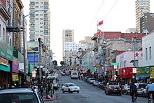
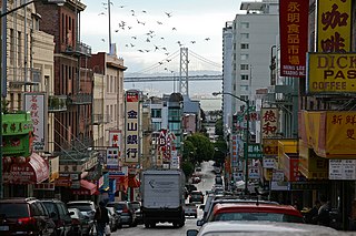
The Chinatown centered on Grant Avenue and Stockton Street in San Francisco, California, is the oldest Chinatown in North America and one of the largest Chinese enclaves outside Asia. It is also the oldest and largest of the four notable Chinese enclaves within San Francisco. Since its establishment in the early 1850s, it has been important and influential in the history and culture of ethnic Chinese immigrants in North America. Chinatown is an enclave that has retained its own customs, languages, places of worship, social clubs, and identity.

<span class="mw-page-title-main">Union Square, San Francisco</span> Neighborhood of San Francisco in California, United States

Union Square is a 2.6-acre (1.1-hectare) public plaza bordered by Geary, Powell, Post, and Stockton Streets in downtown San Francisco, California. "Union Square" also refers to the central shopping, hotel, and theater district that surrounds the plaza for several blocks. The area got its name because it was once used for Thomas Starr King rallies and support for the Union Army during the American Civil War, earning its designation as a California Historical Landmark.

<span class="mw-page-title-main">Sunset Tunnel</span> Streetcar tunnel in San Francisco, California, U.S.

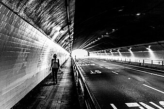
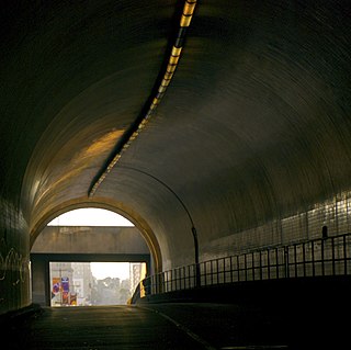
The Sunset Tunnel, originally known as the Duboce Tunnel, is a 4,232 ft (1,290 m)-long light rail/streetcar tunnel in San Francisco, California. The tunnel runs under the steep hill adjacent to Buena Vista Park and is used exclusively by the N Judah Muni Metro line.

<span class="mw-page-title-main">Central Subway (San Francisco)</span> Underground light rail line

The Central Subway is a Muni Metro light rail tunnel in San Francisco, California, United States. It runs between Chinatown station in Chinatown and a portal in South of Market (SoMa), with intermediate stops at Union Square/Market Street station in Union Square and Yerba Buena/Moscone station in SoMa. A surface portion runs through SoMa to connect to the previously existing T Third Street line at 4th and King station.

<span class="mw-page-title-main">Market Street subway</span> BART-Muni Metro main line, San Francisco

The Market Street subway is a two-level subway tunnel that carries Muni Metro and BART trains under Market Street in San Francisco, California. It runs under the length of Market Street between Embarcadero station and Castro station. The upper level is used by Muni Metro lines and the lower level is used by BART lines. BART does not run through the whole subway; it turns south and runs under Mission Street southwest of Civic Center/UN Plaza station. The northeastern end of the BART level is connected to the Transbay Tube. On the Muni Metro level, the southwestern end of the Market Street subway connects to the much-older Twin Peaks Tunnel, and the northeastern end connects to surface tracks along the Embarcadero.

<span class="mw-page-title-main">California State Route 480</span> Former highway in California

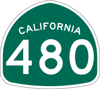
State Route 480 was a state highway in San Francisco, California, United States, consisting of the elevated double-decker Embarcadero Freeway, the partly elevated Doyle Drive approach to the Golden Gate Bridge and the proposed and unbuilt section in between. The unbuilt section from Doyle Drive to Van Ness Avenue was to have been called the Golden Gate Freeway and the Embarcadero Freeway as originally planned would have extended from Van Ness along the north side of Bay Street and then along the Embarcadero to the San Francisco-Oakland Bay Bridge.

<span class="mw-page-title-main">Chinatown, Oakland, California</span> Neighborhood of Oakland in Alameda, California, United States

The Chinatown neighborhood in Oakland, California, is traditionally Chinese which reflects Oakland's diverse Chinese American, and more broadly Asian American community. It is frequently referred to as "Oakland Chinatown" in order to distinguish it from nearby San Francisco's Chinatown. It lies at an elevation of 39 feet.

<span class="mw-page-title-main">Kearny Street</span> Street in San Francisco

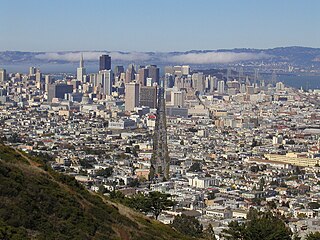
Kearny Street in San Francisco, California runs north from Market Street to The Embarcadero. Toward its south end, it separates the Financial District from the Union Square and Chinatown districts. Further north, it passes over Telegraph Hill, interrupted by a gap near Coit Tower.

<span class="mw-page-title-main">T Third Street</span> San Francisco light rail line

The T Third Street is a Muni Metro light rail line in San Francisco, California. It runs along the east side of San Francisco from Sunnydale to Chinatown, traveling in the median of Third Street for most of its length before entering the Central Subway as it approaches downtown. The line serves 22 stations, all of which are accessible. Most of the surface portion of the line runs in dedicated median lanes, though two portions operate in mixed traffic.

<span class="mw-page-title-main">The Emporium (San Francisco)</span>

The Emporium, from 1980 to 1995 Emporium-Capwell, was a mid-line department store chain headquartered in San Francisco, California, which operated for 100 years—from 1896 to 1996. The flagship location on San Francisco's Market Street was a destination shopping location for decades, and several branch stores operated in the various suburbs of the Bay Area. The Emporium and its sister department store chains were acquired by Federated Department Stores in 1995, and many converted to Macy's locations.

<span class="mw-page-title-main">Market Street (San Francisco)</span> Thoroughfare in San Francisco, United States

Market Street is a major thoroughfare in San Francisco, California. It begins at The Embarcadero in front of the Ferry Building at the northeastern edge of the city and runs southwest through downtown, passing the Civic Center and the Castro District, to the intersection with Portola Drive in the Twin Peaks neighborhood. Beyond this point, the roadway continues into the southwestern quadrant of San Francisco. Portola Drive extends south to the intersection of St. Francis Boulevard and Sloat Boulevard, where it continues as Junipero Serra Boulevard.

<span class="mw-page-title-main">California Street (San Francisco)</span>

California Street is a major thoroughfare in San Francisco, California. It is one of the longest streets in San Francisco, and includes a number of important landmarks. It runs in an approximately straight 5.2 mi (8.4 km) east–west line from the Financial District to Lincoln Park in the far northwest corner of the city.

<span class="mw-page-title-main">Broadway Tunnel (San Francisco)</span> Road underpass in San Francisco, California, U.S.

The Broadway Tunnel is a roadway tunnel in San Francisco, California. The tunnel opened in 1952, and serves as a high-capacity conduit for traffic between Chinatown and North Beach to the east and Russian Hill and Van Ness Avenue to the west. In a proposal of the city's 1948 Transportation Plan, the tunnel was to serve as a link between the Embarcadero Freeway and the Central Freeway.

<span class="mw-page-title-main">Grant Avenue</span>

Grant Avenue in San Francisco, California, is one of the oldest streets in the city's Chinatown district. It runs in a north–south direction starting at Market Street in the heart of downtown and dead-ending past Francisco Street in the North Beach district. It resumes at North Point Street and stretches one block to The Embarcadero and the foot of Pier 39.

<span class="mw-page-title-main">Stockton Street Tunnel</span> Road tunnel in San Francisco

The Stockton Street Tunnel is a tunnel in San Francisco, California, which carries its namesake street underneath a section of Nob Hill near Chinatown for about three blocks. It was opened in 1914. The south portal is located just shy of Bush Street, which is about two blocks to the north of Union Square. The north portal is located just to the south of the Sacramento Street intersection.

<span class="mw-page-title-main">Maiden Lane (San Francisco)</span>

Maiden Lane is a pedestrian mall located in San Francisco, California, United States. A former section of the city's red light district, Maiden Lane is now home to high-end boutiques and art galleries. The street also serves as the location of San Francisco's only Frank Lloyd Wright designed building.

<span class="mw-page-title-main">Rose Pak</span> American political activist

Rose Lan Pak was a political activist in San Francisco, California, noted for her influence on city politics and power in the Chinatown community. Pak served as a consultant for the San Francisco Chinese Chamber of Commerce and organizer of the Chinese New Year Parade in San Francisco. Although Pak never held an elective political office, she was known as an outspoken, controversial but well-connected "gatekeeper" figure who supported politicians by raising funds and connecting them with the city's growing Asian American community. Her political ties to the Chinese government attracted scrutiny.

<span class="mw-page-title-main">Chinatowns in the United States</span> Ethnic Chinese enclaves in the United States

Chinatowns are enclaves of Chinese people outside of China. The first Chinatown in the United States was San Francisco's Chinatown in 1848, and many other Chinatowns were established in the 19th century by the Chinese diaspora on the West Coast. By 1875, Chinatowns had emerged in eastern cities such as New York City, Boston, and Philadelphia. The Chinese Exclusion Act of 1882 barred Chinese immigration to the United States, but the Magnuson Act of 1943 repealed it, and the population of Chinatowns began to rise again. In the 2010s, the downturn in the U.S. economy caused many Chinese Americans to return to China.

<span class="mw-page-title-main">Chinatown station (Muni Metro)</span> Subway station in San Francisco, California, US

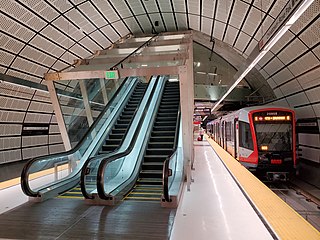
Chinatown station is an underground Muni Metro light rail station, located under Stockton Street at Washington Street in the Chinatown neighborhood of San Francisco, California. It opened on November 19, 2022, as part of the Central Subway project. The station's official name honors Rose Pak, a political activist in the Chinatown community who helped secure support and funding for the station and the extension of the T Third Street line.

<span class="mw-page-title-main">30 Stockton</span> Trolleybus route in San Francisco, California

30 Stockton is a trolleybus line operated by the San Francisco Municipal Railway. The line is notable for being the slowest trolleybus route in the city of San Francisco because it travels through the densely populated neighborhood of Chinatown.
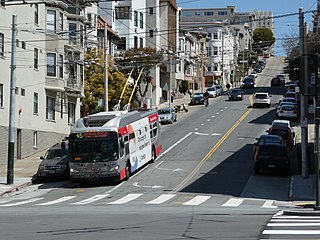
References

  1. Stockton Street reviews from TripAdvisor
  2. Stockton Street, Gucci and Cole Haan are located on Stockton St. San Francisco
  3. The location of Stockton Street in San Francisco, Google Maps.
  4. 1 2 3 Nolte, Carl (February 7, 2010). "Shopping for a new year". San Francisco Chronicle .
  5. Kam, Katherine (December 9, 2001) "Where Chinatown Reveals Itself" The New York Times
  6. Wildermuth, John; Tucker, Jill (February 5, 2015). "Mayor puts his shine on new supervisor in Chinatown". San Francisco Chronicle.
  7. 1 2 3 Noah Christman, Deland Chan, Vivian Chang and Cindy Wu (April 9, 2012). "Creating a Community Vision for Stockton Street". SPUR.{{cite web}}: CS1 maint: multiple names: authors list (link)
  8. 1 2 3 Nolte, Carl (February 13, 2016). "Strolling Stockton Street, the heart of Chinatown". San Francisco Chronicle. Retrieved February 17, 2016. ... San Francisco's most interesting street. That would be the five blocks of Stockton Street, between Sacramento Street and Broadway [...] Concentrating most of the shops on Stockton is a fairly new development, which happened after immigration laws were relaxed in the mid-1960s. New people poured into Chinatown and old Stockton Street took on a new look.
  9. "A Brief History of the F-Market & Wharves Line | Market Street Railway". Market Street Railway. Retrieved February 22, 2016.
  10. Bialick, Aaron (January 28, 2015). "Stockton Street "Winter Walk" Plaza to Return Next Holiday Season". Streetsblog SF.
  11. "Rose Pak flashes red light on Stockton Street pedestrian mall" . Retrieved September 19, 2016.
  12. Matier, Phil (August 8, 2016). "Rose Pak Threatens City Hall Blockade Over Stockton Street Proposal" . Retrieved September 19, 2016.
  13. Pierce, Phillip (February 19, 2019). "Lower Stockton Street to Reopen to Traffic and Transit". San Francisco Municipal Transportation Agency. Retrieved April 24, 2020.
  14. "Academy of Art University Campus Map" (PDF). academyart.edu. Academy of Art University . Retrieved November 23, 2016.
Template:Attached KML/Stockton Street (San Francisco)
KML is not from Wikidata