South of Market (SoMa) is a neighborhood in San Francisco, California, situated just south of Market Street. It contains several sub-neighborhoods including South Beach, Yerba Buena, and Rincon Hill.

Bernard Ralph Maybeck was an American architect in the Arts and Crafts Movement of the early 20th century. He worked primarily in the San Francisco Bay Area, designing public buildings, including the Palace of Fine Arts in San Francisco, and also private houses, especially in Berkeley, where he lived and taught at the University of California. A number of his works are listed on the National Register of Historic Places.

The Financial District is a neighborhood in San Francisco, California, United States, that serves as its main central business district and had 372,829 jobs according to U.S. census tracts as of 2012-2016. It is home to the city's largest concentration of corporate headquarters, law firms, insurance companies, real estate firms, savings and loan banks, and other financial institutions. Multiple Fortune 500 companies headquartered in San Francisco have their offices in the Financial District, including Wells Fargo, Salesforce, and Gap.
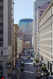
Montgomery Street is a north-south thoroughfare in San Francisco, California, in the United States.

William Chapman Ralston was a San Francisco businessman and financier, and the founder of the Bank of California.

The Academy of Art University, formerly Academy of Art College and Richard Stephens Academy of Art, is a private for-profit art school in San Francisco, California. It was founded as the Academy of Advertising Art by Richard S. Stephens in 1929. The school is one of the largest property owners in San Francisco, with the main campus located on New Montgomery Street in the South of Market district.

Octavia Boulevard is a major street in San Francisco, California, United States, that replaced the Hayes Valley portion of the damaged two-level Central Freeway. Once a portion of Octavia Street alongside shadowy, fenced-off land beneath the elevated U.S. Route 101 roadway, Octavia Boulevard was redeveloped and redesigned upon the recommendation of a "Central Freeway" planning committee representing a broad array of neighborhoods, including the surrounding Hayes Valley and Western Addition, the Richmond District, Pacific Heights and the Sunset District with representatives appointed by Mayor Willie Brown and the Board of Supervisors and led by the Planning Department of San Francisco. Elements of the San Francisco General Plan were consulted for issues such as urban design, transportation mobility and congestion management, community safety and historic preservation, along with the evaluation of the impacts following the recent removal (1991) of the elevated Embarcadero Freeway and the revitalization of the Embarcadero as a surface boulevard complemented by an extension of the Muni Metro light-rail transit subway.

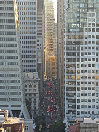
Kearny Street in San Francisco, California runs north from Market Street to The Embarcadero. Toward its south end, it separates the Financial District from the Union Square and Chinatown districts. Further north, it passes over Telegraph Hill, interrupted by several gaps near Coit Tower due to the steep terrain.

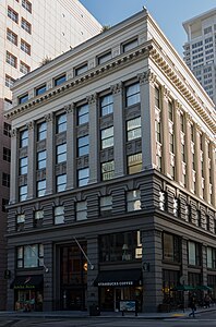
The Palace Hotel is a landmark historic hotel in San Francisco, California, located at the southwest corner of Market and New Montgomery streets. The hotel is also referred to as the New Palace Hotel to distinguish it from the original 1875 Palace Hotel, which had been demolished after being gutted by the fire caused by the 1906 San Francisco earthquake.

Henry Perrin Coon was the 10th Mayor of San Francisco who served from July 1, 1863, to December 1, 1867. He was one of the most versatile men ever to hold the office, having previously worked as a teacher, doctor, lawyer, druggist and businessman.
The San Francisco Transbay development is a completed redevelopment plan for the neighborhood surrounding the Salesforce Transit Center site, South of Market near the Financial District in San Francisco, California. The new transit center replaced the since-demolished San Francisco Transbay Terminal, and new skyscrapers, such as Salesforce Tower, took advantage of the height increases allowed through the San Francisco Transit Center District Plan. The sale of several land parcels formerly owned by the state and given to the managing Transbay Joint Powers Authority helped finance the construction of the transit center.

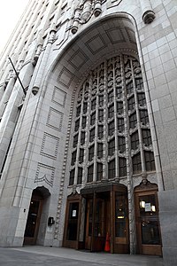
140 New Montgomery Street is a 26-floor Art Deco mixed-use office tower located in San Francisco's South of Market district, close to the St. Regis Museum Tower and the San Francisco Museum of Modern Art. Constructed in 1925 as a modern headquarters for The Pacific Telephone & Telegraph Co., it was originally known as The Pacific Telephone & Telegraph Company Building or simply the Telephone Building, and, after 1984, as The Pacific Bell Building or The PacBell Building.
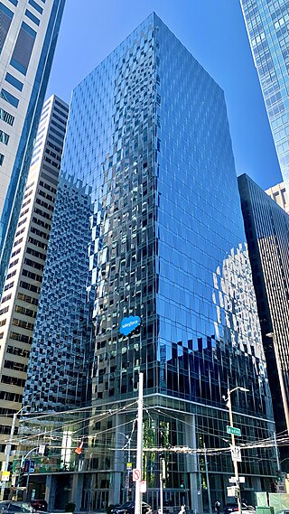
Salesforce East is a 30-story skyscraper in the South of Market district of San Francisco, California.

Stockton Street is a north-south street in San Francisco. It begins at Market Street passing Union Square, a major shopping district in the city. It then runs underground for about two and a half blocks in Stockton Street Tunnel, passes through Chinatown and North Beach, and ends at Beach Street near the Pier 39 shopping center and tourist attraction.
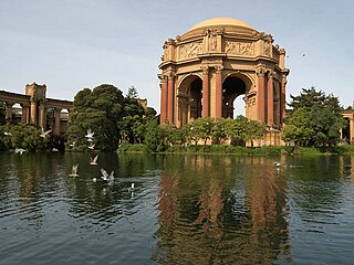
The Marina District is a neighborhood located in San Francisco, California. The neighborhood sits on the site of the 1915 Panama–Pacific International Exposition, staged after the 1906 San Francisco earthquake to celebrate the reemergence of the city. Aside from the Palace of Fine Arts, all other buildings were demolished to make the current neighborhood.
Foundry Square is a complex of four architecturally-linked, 10-story mid-rise buildings located at Howard and First Streets near the Salesforce Transit Center in the South of Market neighborhood of San Francisco, California. Each of the four buildings stands on a different corner of the street.

Jackson Street is a street in San Francisco, California, running through the Pacific Heights, Nob Hill, Chinatown and Jackson Square districts of the city. It runs between Pacific Avenue and Washington Street, beginning at Arguello Boulevard to the south of the Presidio Golf Course and ending at Drumm Street, to the west of Pier 3, near Sydney G. Walton Square.

Nob Hill is a neighborhood of San Francisco, California, United States that is known for its numerous luxury hotels and historic mansions. Nob Hill has historically served as a center of San Francisco's upper class. Nob Hill is among the highest-income neighborhoods in the United States, as well as one of the most desirable and expensive real estate markets in the country. Prior to Covid-19, it was the most expensive real estate market per metre squared, narrowly beating Monte Carlo, although it has since fallen heavily. It was the only place in the United States so far where market price per square metre exceeded the average yearly salary in the country.

John P. Gaynor was an Irish American architect practicing in New York City and San Francisco during the nineteenth century.