Financial District, San Francisco

Last updated
Financial District
Financial District, San Francisco.jpg
San Francisco Financial District as seen from Buena Vista Park
Nicknames: 
"FiDi", [1] "Downtown"
Location map San Francisco Central.png
Red pog.svg
Financial District
Location within San Francisco
Coordinates: 37°47′43″N122°24′10″W / 37.7952°N 122.4029°W / 37.7952; -122.4029
Country Flag of the United States (23px).png  United States
State Flag of California.svg  California
City-county San Francisco
Government
   Supervisor Julie Christensen
   Assemblymember Matt Haney (D) [2]
   State senator Scott Wiener (D) [2]
   U.S. rep. Nancy Pelosi (D) [3]
Area
[4]
  Total0.460 sq mi (1.19 km2)
  Land0.460 sq mi (1.19 km2)
Population
[4]
  Total9,447
  Density21,000/sq mi (7,900/km2)
Time zone UTC−8 (Pacific)
  Summer (DST) UTC−7 (PDT)
ZIP codes
94104, 94108, 94111, 94133
Area codes 415/6 28

The Financial District is a neighborhood in San Francisco, California, United States, that serves as its main central business district and had 372,829 jobs according to U.S. census tracts as of 2012-2016. [5] It is home to the city's largest concentration of corporate headquarters, law firms, insurance companies, real estate firms, savings and loan banks, and other financial institutions. Multiple Fortune 500 companies headquartered in San Francisco have their offices in the Financial District, including Wells Fargo, Salesforce, Uber, Gap, and Williams-Sonoma. [6]

Contents

Since the 1980s, restrictions on high-rise construction have shifted new development to the adjacent South of Market (SoMa) area surrounding the Transbay Transit Center. This area is sometimes called the South Financial District by real estate developers, or simply included as part of the Financial District itself. [7] [8]

The early 2020s have seen high office vacancy rates in the Financial District, driven by remote work since the COVID-19 pandemic, particularly among tech companies. [9] [10] [11] Several owners of office buildings and hotels have defaulted on their loans, [12] [13] raising concerns about the effect on San Francisco's tax revenues and the financial stability of local government services. [14]

The area is marked by the cluster of high-rise towers in the triangular area east of Kearny Street, [15] south of Washington Street, west of the Embarcadero that rings the waterfront, and north of Market Street. The district includes Northern California's two tallest buildings, the Salesforce Tower and the Transamerica Pyramid. Montgomery Street (sometimes called "Wall Street of the West") is the traditional heart of the district.

History

Under Spanish and Mexican rule, the area had been the site of a harbor named Yerba Buena Cove with a small civilian outpost named Yerba Buena that served to support the military population of the Presidio and the Mission Dolores. The sandy, marshy soils of the tip of the San Francisco Peninsula discouraged the Spanish, and later Mexican governments from establishing a preeminent town there, who focused their pueblo settlement efforts in the Pueblo of San José with its extremely fertile land. It was not until 1835 that the first settlers established themselves on the shore of Yerba Buena Cove, with the first town plan surveyed in 1839. [16] Yerba Buena's potential as a seaport made it the eventual center for European and American settlement.

After gold was discovered in the Sierra Nevada Foothills in 1848, Yerba Buena's location on the natural harbor of San Francisco Bay acted as a magnet for European and American settlers, as well as gold and job seekers from a multitude of countries. Following Californian independence and American annexation and the California Gold Rush, the area boomed rapidly and the Bay shoreline, which originally ended near Montgomery Street, was filled in and extended to The Embarcadero. Gold Rush wealth and business made it the financial capital of the west coast as many banks and businesses set up in the neighborhood. The west coast's first and only skyscrapers, were built in the area along Market Street.

The neighborhood was nearly completely destroyed in the 1906 Earthquake and Fire, as the area's skyscrapers survived. By 1910, the area was largely rebuilt with low-rise, masonry-clad buildings ranging from six to twelve stories in height. [17] During the late 1920s, several Neo-Gothic high rises, reaching 300 to 400 feet in height, were constructed, including the Standard Oil Building, Russ Building, Hunter-Dulin Building, Shell Building, and the Pacific Telephone Building. [17]

The Financial District, looking east down California Street SF California Street USA.jpg
The Financial District, looking east down California Street

With the onset of the Great Depression and statewide height restrictions due to earthquake fears, few new buildings were constructed, and the district remained relatively low-rise until the late 1950s. Due to new building and earthquake retrofitting technologies, the height restrictions were lifted, fueling a skyscraper building boom. [17] This boom accelerated under mayor Dianne Feinstein during the 1980s, something her critics labeled "Manhattanization". [18] This caused widespread opposition citywide leading to the "skyscraper revolt" similar to the "freeway revolt" in the city years earlier. The skyscraper revolt led to the city imposing extremely strict, European-style height restrictions on building construction citywide.

Due to these height restrictions, lack of buildable lots, and changes in the local real estate market, new development in the area has shifted to South of Market Street since the 1980s. The area south of Market, east of Third Street, north of Folsom Street, and west of the Embarcadero is sometimes called the South Financial District, or simply included as part of the Financial District itself. [7] To encourage new development south of Market, and to help fund the replacement for the Transbay Terminal, many height limits were raised in the area. As a result, nearly all new high rise construction since the 1980s (and for the foreseeable future) has taken place South of Market. Notable examples include the JPMorgan Chase Building, 555 Mission Street, 101 Second Street, the Four Seasons Hotel, The Paramount, and the Millennium Tower.

According to TRI Commercial, the traditional Financial District provides approximately 30 million square feet (2,800,000 m2) of office space, and the South Financial District offers about 28 million square feet (2,600,000 m2). [19] Altogether, the combined Financial District had employed over 220,000 office workers. [17] In the 2020s, the COVID-19 pandemic has stimulated an exodus of business from the downtown core of San Francisco. [20]

Location

The former Pacific Stock Exchange on Pine Street in the Financial District Pacific Exchange 301 Pine.jpg
The former Pacific Stock Exchange on Pine Street in the Financial District

Adjacent to the Financial District to the west is the Union Square shopping district. To the northwest is Chinatown, and to the north is North Beach and Jackson Square. To the east lies the Embarcadero waterfront and the Ferry Building. To the south lies Market Street and the South of Market district.

The Financial District is served by more than two dozen Muni bus and rail lines, including one cable car line, as well as Montgomery Street Station and Embarcadero Station in the BART system.

The nickname "FiDi" is occasionally employed, [1] analogous to nearby SoMa. The area is commonly referred to as "Downtown" as well, although "Downtown" may include the broader Union Square, Chinatown, Tenderloin, and SoMa districts as well.

Characteristics

The Transamerica Pyramid was the tallest building in San Francisco from 1972 until 2017, when it was surpassed by the Salesforce Tower. SF Transamerica full CA.jpg
The Transamerica Pyramid was the tallest building in San Francisco from 1972 until 2017, when it was surpassed by the Salesforce Tower.

The District is home to numerous corporate headquarters, including all six San Francisco Fortune 500 companies—McKesson Corporation, Wells Fargo, PG&E, Gap, Charles Schwab, and Salesforce.com [21] as well as Bechtel, the Union Bank of California, Levi Strauss & Co., Blue Shield, Kimpton Hotels & Restaurants, URS Corporation, and Bank of the West among others; and formerly Bank of America, Pacific Bell, Crocker Bank, Transamerica Corporation, Chevron Corporation, and Visa among others. The headquarters of the 12th district of the United States Federal Reserve is located in the area as well. Prior to their disestablishment, AirTouch, South Pacific Air Lines, Pegasus Aviation Finance Company, and the Pacific Exchange all had their headquarters in the Financial District. [22] [23] [24]

There are several shopping malls in the area, including the Crocker Galleria, the Embarcadero Center, the Ferry Building Marketplace, and the Rincon Center complex. Parks and plazas located there include Sue Biermann Park; Justin Herman Plaza, which is the current location of the city's New Year's festivities, and Transamerica Redwood Park. St. Mary's Square and Portsmouth Square are near the borders of the district, but are usually considered as part of Chinatown.

Diplomatic missions

Several consulates are located in the financial district. Countries with consulates in the Financial District include France, [25] Brazil, [26] Guatemala, [27] Japan, [28] [29] Luxembourg, [30] Mexico, [31] Ireland, [32] the Netherlands, [33] Singapore, [34] and the United Kingdom. [35] The Hong Kong Economic and Trade Office and the Taipei Economic and Cultural Office is located in the Financial District. [36]

See also

Related Research Articles

<span class="mw-page-title-main">Transamerica Pyramid</span> Skyscraper in San Francisco

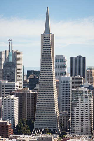
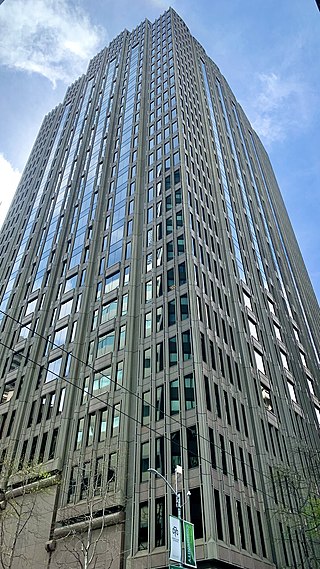
The Transamerica Pyramid is a pyramid-shaped 48-story modernist skyscraper in San Francisco, California, United States, and the second tallest building in the San Francisco skyline. Located at 600 Montgomery Street between Clay and Washington Streets in the city's Financial District, it was the tallest building in San Francisco from its completion in 1972 until 2018 when the newly-constructed Salesforce Tower surpassed its height. The building no longer houses the headquarters of the Transamerica Corporation, which moved its U.S. headquarters to Baltimore, Maryland. The building is still associated with the company by being depicted on the company's logo. Designed by architect William Pereira and built by Hathaway Dinwiddie Construction Company, the building stands at 853 feet (260 m). On completion in 1972 it was the eighth-tallest building in the world. It is also a popular tourist site. In 2020, the building was sold to NYC investor Michael Shvo, who in 2022 hired Norman Foster to redesign the interiors and renovate the building.

<span class="mw-page-title-main">South of Market, San Francisco</span> Neighborhood in San Francisco, California, US

South of Market (SoMa) is a neighborhood in San Francisco, California, situated just south of Market Street. It contains several sub-neighborhoods including South Beach, Yerba Buena, and Rincon Hill.

<span class="mw-page-title-main">Yerba Buena Gardens</span> Two blocks of public parks in San Francisco, California

Yerba Buena Gardens is the name for two blocks of public parks located between Third and Fourth, Mission and Folsom Streets in the South of Market (SoMA) neighbourhood of San Francisco, California. The first block bordered by Mission and Howard Streets was opened on October 11, 1993. The second block, between Howard and Folsom Streets, was opened in 1998, with a dedication to Martin Luther King Jr. by Mayor Willie Brown. A pedestrian bridge over Howard Street connects the two blocks, sitting on top of part of the Moscone Center convention center. The Yerba Buena Gardens were planned and built as the final centerpiece of the Yerba Buena Redevelopment Area which includes the Yerba Buena Center for the Arts. Yerba Buena Gardens Conservancy operates the property on behalf of the City and County of San Francisco.

<span class="mw-page-title-main">Embarcadero (San Francisco)</span> Waterfront and roadway along San Francisco Bay

The Embarcadero is the eastern waterfront of Port of San Francisco and a major roadway in San Francisco, California. It was constructed on reclaimed land along a three mile long engineered seawall, from which piers extend into the bay. It derives its name from the Spanish verb embarcar, meaning "to embark"; embarcadero itself means "the place to embark." The Central Embarcadero Piers Historic District was added to the National Register of Historic Places on November 20, 2002.

<span class="mw-page-title-main">Montgomery Street</span> Street in San Francisco, United States

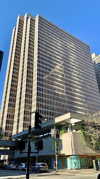
Montgomery Street is a north-south thoroughfare in San Francisco, California, in the United States.

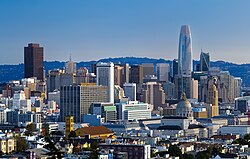
The history of the city of San Francisco, California, and its development as a center of maritime trade, were shaped by its location at the entrance to a large natural harbor. San Francisco is the name of both the city and the county; the two share the same boundaries. Only lightly settled by European-Americans at first, after becoming the base for the gold rush of 1849 the city quickly became the largest and most important population, commercial, naval, and financial center in the American West. San Francisco was devastated by a great earthquake and fire in 1906 but was quickly rebuilt. The San Francisco Federal Reserve Branch opened in 1914, and the city continued to develop as a major business city throughout the first half of the 20th century. Starting in the later half of the 1960s, San Francisco became the city most famous for the hippie movement. In recent decades, San Francisco has become an important center of finance and technology. The high demand for housing, driven by its proximity to Silicon Valley, and the limited availability has led to the city being one of America's most expensive places to live. San Francisco is currently ranked 16th on the Global Financial Centres Index.

<span class="mw-page-title-main">Port of San Francisco</span> Organization that oversees port facilities in San Francisco, California, United States

The Port of San Francisco is a semi-independent organization that oversees the port facilities at San Francisco, California, United States. It is run by a five-member commission, appointed by the Mayor and approved by the Board of Supervisors. The Port is responsible for managing the larger waterfront area that extends from the anchorage of the Golden Gate Bridge, along the Marina district, all the way around the north and east shores of the city of San Francisco including Fisherman's Wharf and the Embarcadero, and southward to the city line just beyond Candlestick Point. In 1968, the State of California, via the California State Lands Commission for the State-operated San Francisco Port Authority, transferred its responsibilities for the Harbor of San Francisco waterfront to the City and County of San Francisco / San Francisco Harbor Commission through the Burton Act AB2649. All eligible State port authority employees had the option to become employees of the City and County of San Francisco to maintain consistent operation of the Port of San Francisco.

<span class="mw-page-title-main">Kearny Street</span> Street in San Francisco

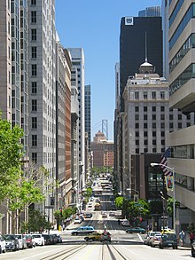
Kearny Street in San Francisco, California runs north from Market Street to The Embarcadero. Toward its south end, it separates the Financial District from the Union Square and Chinatown districts. Further north, it passes over Telegraph Hill, interrupted by a gap near Coit Tower.

<span class="mw-page-title-main">Rincon Hill, San Francisco</span> Neighborhood of San Francisco

Rincon Hill is a neighborhood in San Francisco, California. It is one of San Francisco's many hills, and one of its original "Seven Hills". The relatively compact neighborhood is bounded by Folsom Street to the north, the Embarcadero to the east, Bryant Street on the south, and Essex Street to the west. Named after Rincon Point that formerly extended into the bay there, Rincon Hill is located just south of the Transbay development area, part of the greater South of Market area. The hill is about 100 feet tall.

<span class="mw-page-title-main">Market Street (San Francisco)</span> Thoroughfare in San Francisco, United States

Market Street is a major thoroughfare in San Francisco, California. It begins at The Embarcadero in front of the Ferry Building at the northeastern edge of the city and runs southwest through downtown, passing the Civic Center and the Castro District, to the intersection with Portola Drive in the Twin Peaks neighborhood. Beyond this point, the roadway continues into the southwestern quadrant of San Francisco. Portola Drive extends south to the intersection of St. Francis Boulevard and Sloat Boulevard, where it continues as Junipero Serra Boulevard.

The San Francisco Transbay development is a completed redevelopment plan for the neighborhood surrounding the Transbay Transit Center site, South of Market near the Financial District in San Francisco, California. The new transit center replaced the since-demolished San Francisco Transbay Terminal, and new skyscrapers, such as Salesforce Tower, took advantage of the height increases allowed through the San Francisco Transit Center District Plan. The sale of several land parcels formerly owned by the state and given to the managing Transbay Joint Powers Authority helped finance the construction of the transit center.

<span class="mw-page-title-main">140 New Montgomery</span> Mixed-use

140 New Montgomery Street is a 26-floor Art Deco mixed-use office tower located in San Francisco's South of Market district, close to the St. Regis Museum Tower and the San Francisco Museum of Modern Art. Constructed in 1925 as a modern headquarters for The Pacific Telephone & Telegraph Co., it was originally known as The Pacific Telephone & Telegraph Company Building or simply the Telephone Building, and, after 1984, as The Pacific Bell Building or The PacBell Building.

<span class="mw-page-title-main">275 Battery Street</span> Commercial offices in San Francisco, California

275 Battery Street, formerly known as Embarcadero West, is a 30-story, 123.1 m (404 ft) office skyscraper in the Financial District of San Francisco, California.

<span class="mw-page-title-main">Two Embarcadero Center</span> Commercial offices in San Francisco, California

Two Embarcadero Center is an office skyscraper located off The Embarcadero in the financial district of San Francisco, California. The 126 m (413 ft), 30-story tower, completed in 1974 is part of the Embarcadero Center, a complex of seven towers, of which two are hotels. Twin-tower Three Embarcadero Center is the same height, but has one additional floor.

<span class="mw-page-title-main">181 Fremont</span> 803-foot mixed-use skyscraper in the South of Market District of San Francisco

181 Fremont is an 803-foot (245 m) mixed-use skyscraper in the South of Market District of San Francisco, California. The building, designed by Heller Manus Architects, is located adjacent to the Transbay Transit Center and 199 Fremont Street developments. 181 Fremont is owned and operated by Jay Paul Company, which was the sole developer of the project. The entire office portion of the building was leased to Facebook to house its San Francisco office and Instagram division.

<span class="mw-page-title-main">350 Mission Street</span> Commercial offices in San Francisco, California

Salesforce East is a 30-story skyscraper in the South of Market district of San Francisco, California.

<span class="mw-page-title-main">Providian Financial Building</span> Office in California, USA

The Providian Financial Building is a high-rise office building located at 201 Mission Street in the South of Market district of San Francisco, California. The building stands at a height of 417 feet (127 m) and has 30 stories. Its construction was completed in 1981.

The San Francisco Redevelopment Agency (SFRA) was an urban renewal agency active from 1948 until 2012, with purpose to improve the urban landscape through "redesign, redevelopment, and rehabilitation" of specific areas of the city.

References

  1. 1 2 "Financial District (FiDi) neighborhood in San Francisco, California (CA), 94104, 94108, 94111, 94133 detailed profile". City-Data. 2011. Retrieved 2012-12-03.
  2. 1 2 "Statewide Database". UC Regents. Retrieved November 5, 2014.
  3. "California's 11th Congressional District - Representatives & District Map". Civic Impulse, LLC.
  4. 1 2 "Financial District (FiDi) neighborhood in San Francisco, California (CA), 94104, 94108, 94111, 94133 detailed profile". Urban mapping. Retrieved February 19, 2015.
  5. "Demographia United States Central Business Districts" (PDF).
  6. "Fortune 500". Fortune. Retrieved 2022-08-29.
  7. 1 2 San Francisco Commercial Real Estate Market Boundaries--South Financial District
  8. Simonson, Sharon (March 4, 2013). "San Francisco City: Next 30 Years, SoMa Surges, Financial District Fades". The Registry. Retrieved December 27, 2013.
  9. San Feancisco Chronicle Editorial Board (August 21, 2022). "Downtown San Francisco is dying. This bill could help save it". San Francisco Chronicle. Retrieved December 17, 2022.
  10. Roland Li (August 13, 2022). "New York is roaring back from the worst of the pandemic. Why isn't San Francisco?". San Francisco Chronicle. Retrieved February 24, 2023.
  11. Conor Dougherty; Emma Goldberg (December 17, 2022). "What Comes Next for the Most Empty Downtown in America" . The New York Times. Retrieved December 17, 2022. On any given week in San Francisco, office buildings are at about 40 percent of their prepandemic occupancy.
  12. Li, Roland (January 12, 2024). "Another big S.F. hotel defaults on mortgage — a bad sign for city's tourism industry". San Francisco Chronicle. Retrieved April 4, 2024.
  13. Li, Roland (September 28, 2023). "More S.F. office buildings are defaulting on mortgages as real estate pain spreads". San Francisco Chronicle. Retrieved April 4, 2024.
  14. Morris, J.D.; Rezal, Adriana (May 3, 2023). "Why bad news for downtown is also bad news for the rest of San Francisco". The San Francisco Chronicle. Retrieved April 4, 2024.
  15. King, John (June 20, 2006). "Kearny Street's timeless in its pedestrian way". San Francisco Chronicle.
  16. Hayes, Derek (2007). Historical Atlas of California . Berkeley: "University of California Press".
  17. 1 2 3 4 "San Francisco General Plan - Downtown Area Plan". City & County of San Francisco. Archived from the original on 2012-12-08. Retrieved 2012-12-27.
  18. Toner, Robin (30 September 1990). "California Showdown" . The New York Times Magazine . Archived from the original on 2020-02-14. Retrieved 2020-02-14.
  19. "SAN FRANCISCO TRENDS: 2015 Q4" (PDF). TRI Commercial Real Estate Services, Inc. Retrieved 2016-02-12.
  20. San Feancisco Chronicle Editorial Board (August 21, 2022). "Downtown San Francidco is dying. This bill could help save it". San Francisco Chronicle. Retrieved December 17, 2022.
  21. Fortune magazine. "FORTUNE 500". Time Inc. Retrieved 12 February 2016.
  22. "Contact Information." AirTouch. Retrieved on January 10, 2010.
  23. "World Airline Survey." Flight International . April 1963. 540. "Head Office: 311 California Street San Francisco, California"
  24. "Contact." Pegasus Aviation. January 11, 2002. Retrieved on August 8, 2011. "Pegasus Aviation, Inc. Four Embarcadero Center, 35th Floor San Francisco, CA 94111 USA"
  25. "French Consulate, San Francisco".
  26. "Addresses and Contacts." Consulate-General of Brazil in San Francisco . Retrieved on February 14, 2020.
  27. "Informacion de la mision Archived 2008-12-16 at the Wayback Machine ." Consulate-General of Guatemala in San Francisco . Retrieved on December 14, 2009.
  28. "Basic information on the office Archived 2007-05-22 at the Wayback Machine ." Consulate-General of Japan in San Francisco . Retrieved on January 31, 2009.
  29. "Japan Information Center Archived 2007-10-12 at the Wayback Machine ." Consulate-General of Japan in San Francisco . Retrieved on January 31, 2009.
  30. "." Consulate-General of Luxembourg in San Francisco . Retrieved on January 31, 2009.
  31. "Contactenos Archived 2009-02-17 at the Wayback Machine ." Consulate-General of Mexico in San Francisco . Retrieved on February 1, 2009.
  32. "." Consulate-General of Ireland in San Francisco . Retrieved on June 2, 2009.
  33. "Netherlands Consulate General in San Francisco, United States." Consulate-General of the Netherlands in San Francisco . Retrieved on June 30, 2012.
  34. "Welcome." Consulate-General of Singapore in San Francisco . Retrieved on January 31, 2009.
  35. "San Francisco Archived 2009-02-21 at the Wayback Machine ." UK in USA. Retrieved on January 31, 2009.
  36. "Contact Us Archived July 18, 2011, at the Wayback Machine ." Taipei Economic and Cultural Office Los Angeles . Retrieved on January 31, 2009.