Civic Center, San Francisco

Last updated
Civic Center
UN Plaza
San Francisco Civic Center Historic District
San Francisco City Hall as seen from 100 Van Ness at dusk (wide).jpg
Aerial view of Civic Center at dusk in 2016, facing north. San Francisco City Hall is featured in the center.
Location map San Francisco Central.png
Red pog.svg
Civic Center
Location within Central San Francisco
Coordinates: 37°46′45″N122°24′57″W / 37.77917°N 122.41583°W / 37.77917; -122.41583
Government
   Supervisor Jane Kim and London Breed ( block bounded by Van Ness, Turk, Golden Gate Ave., & Franklin ).
   State Assembly Matt Haney (D) [1]
   State Senator Scott Wiener (D) [1]
   U. S. Rep. Nancy Pelosi (D) [2]
Area
[3]
  Total1.27 km2 (0.492 sq mi)
  Land1.27 km2 (0.492 sq mi)
Population
 (2008)
  Total10,101
  Density7,925/km2 (20,525/sq mi)
  [3]
ZIP codes
94102, 94109
Area codes 415/628
[3]
San Francisco Civic Center Historic District
Civic Center, SF, CA, jjron 26.03.2012.jpg
San Francisco Civic Center, looking west along UN Plaza to City Hall
LocationRoughly bounded by Golden Gate Ave., 7th, Franklin, Hayes, and Market Sts., San Francisco, California
Area45.6 acres (18.5 ha)
Built1912 [4]
Architectural styleLate 19th and 20th Century revivals
Beaux-Arts
NRHP reference No. 78000757 [5]
Significant dates
Added to NRHPOctober 10, 1978 [5]
Designated NHLDFebruary 27, 1987 [6]

The Civic Center in San Francisco, California, is an area located a few blocks north of the intersection of Market Street and Van Ness Avenue that contains many of the city's largest government and cultural institutions. It has two large plazas (Civic Center Plaza and United Nations Plaza) and a number of buildings in classical architectural style. The Bill Graham Civic Auditorium (formerly the Exposition Auditorium), [4] the United Nations Charter was signed in the Veterans Building's Herbst Theatre in 1945, leading to the creation of the United Nations. It is also where the 1951 Treaty of San Francisco (the peace treaty that officially ended the Pacific War with the Empire of Japan, which had surrendered in 1945) was signed. The San Francisco Civic Center was designated a National Historic Landmark in 1987 [6] and listed in the National Register of Historic Places on October 10, 1978. [5]

Contents

Location

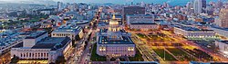
The Civic Center is bounded by Market Street to the southeast, Franklin Street to the west, Turk Street to the north, and Leavenworth Street, McAllister Street, and Charles J. Brenham Place to the east. The Civic Center borders the Tenderloin neighborhood on the north and east and the Hayes Valley neighborhood on the west; Market Street separates it from the South of Market, or "SoMa", neighborhood.

History

Proposed Civic Center from Burnham Plan of 1905. The large semi-circular plaza near the center is at the intersection of Market and Van Ness. San Francisco Plan (Burnham, 1905) (Civic Center crop).png
Proposed Civic Center from Burnham Plan of 1905. The large semi-circular plaza near the center is at the intersection of Market and Van Ness.

The first permanent San Francisco City Hall was completed in 1898 on a triangular-shaped plot in what later became Civic Center, bounded by Larkin, McAllister, and Market, after a protracted construction effort that had started in 1871; although the constructors had promised to complete work within two years, "honest graft" was an accepted practice, and the cost of the structure ballooned from $1 million as budgeted to $8 million. [7] :170

The Civic Center was built in the early 20th century after the earlier City Hall was destroyed in the 1906 earthquake and fire. Although the architect and urban planner Daniel Burnham had provided the city with plans for a neo-classical Civic Center shortly before the 1906 earthquake, [8] his plans were never carried out. Burnham's plan called for a large semi-circular plaza at the intersection of Market and Van Ness as a hub linking official buildings along spoked streets. [9] :10–11

Plan presented for Civic Center in April 1912 with portraits of Mayor Rolph and architectural team. Note the positions of City Hall (east of the central plaza, not west as constructed), and Art Gallery instead of State Building (north of the plaza). Civic Center SF (SF Call, 2 April 1912).png
Plan presented for Civic Center in April 1912 with portraits of Mayor Rolph and architectural team. Note the positions of City Hall (east of the central plaza, not west as constructed), and Art Gallery instead of State Building (north of the plaza).

Following the earthquake, a temporary city hall was established on Market Street, but planning for a permanent structure and civic center did not take place for several years. The current Civic Center was planned by a group of local architects, chaired by John Galen Howard. [7] The new Civic Center would consist of five main buildings facing a central rectangular plaza: City Hall, Auditorium, Main Library, Opera House, and State Office Building. [9] :12 A bond was issued on March 29, 1912, for $8.8 million to carry out the construction of the new Civic Center; at the time, the city only owned the triangular-shaped plot where the old City Hall had stood prior to the earthquake. [10] A resolution passed by the San Francisco Board of Supervisors required the new City Hall to be built on the site of the old City Hall, so early plans for Civic Center showed City Hall east of the central plaza. Opinions solicited by the consulting architectural team led to the relocation of City Hall to the west side of the plaza. [9] :12 Ground was broken for City Hall, the first building in the new Civic Center, on April 5, 1913. [11] [10]

Finalized plan for Civic Center, 1916. Plan of Civic Center (Engineering News-Record, vol 75 no 26 p 1222 fig 1).jpg
Finalized plan for Civic Center, 1916.

The current City Hall was completed in 1915, in time for the Panama–Pacific International Exposition. The second building to be started was Exposition Auditorium; at the time, plans included a new Main Library (to be built on the site of the old City Hall) but left the former Marshall Square (bounded by Larkin, Fulton, Hyde, and Grove) undeveloped. [10] Plans for a new opera house on Marshall Square had been dropped [10] The Main Library (1916), the California State Building (1926), War Memorial Opera House and its neighboring twin, the War Memorial Veterans Building (which together were the nucleus of the San Francisco War Memorial and Performing Arts Center, completed in 1932), and the Old Federal Building (1936) were all completed after the Exposition. Civic Center Plaza was established by 1915, but not completed until 1925. Marshall Square remained undeveloped [9] :12,14 until the new Main Library was constructed there in the early 1990s.

During World War II, Army barracks and Victory gardens were constructed in Civic Center Plaza, which lies directly east of City Hall and west of the Library. The 1950s through the 1970s and 1980s saw tall post-modernist Federal and State buildings constructed in the area; an underground exhibition facility, Brooks Hall, was completed beneath the plaza in 1958, followed by an adjoining garage in 1960. The Louise M. Davies Symphony Hall and Harold L. Zellerbach Rehearsal Hall were added in 1980. The 1990s saw the construction of a new Main Library on the unoccupied Marshall Square block, and the old Main Library building was converted into the Asian Art Museum, and the removal of all public benches. In 1998, the city officially renamed part of the plaza the Joseph L. Alioto Performing Arts Piazza after the former mayor.

Its central location, vast open space, and the collection of government buildings have made and continue to make Civic Center the scene of massive political rallies. It has been the scene of massive anti-war protests and rallies since the Korean War. It was also the scene of major moments of the Gay Rights Movement. Activist Harvey Milk held rallies and gave speeches there. After his assassination on November 27, 1978, a massive candlelight vigil was held there. Later, it was the scene of the White Night Riots in response to the lenient sentencing of Dan White, Milk's assassin. Recently, Civic Center was the center point of same-sex marriage activism, as Mayor Gavin Newsom married couples there.

Attractions and characteristics

Civic Center, San Francisco
This is a stopgap mapping solution, while attempts are made to resolve technical difficulties with {{ OSM Location map }}
Selected locations in Civic Center, San Francisco 
  •  Government 
  •  Monuments 
  •  Culture 
  •  Parks and open spaces 
  •  Transit stops 
  •  Education 

1
California Public Utilities Commission
2
Herbst Theatre
3
War Memorial Opera House
4
Davies Symphony Hall
5
San Francisco Public Utilities Commission
6
San Francisco County Superior Court (Civic Center Courthouse)
7
San Francisco City Hall
8
Phillip Burton Federal Building / US District Court, N.D. Cal.
9
Earl Warren Building / Supreme Court of California
10
Civic Center Plaza
11
Bill Graham Civic Auditorium
12
Asian Art Museum
13
Pioneer Monument
14
Main Library
15
University of California, Hastings College of the Law
16
50 UN Plaza
17
SHN Orpheum Theatre
18
UN Plaza
19
Civic Center/​UN Plaza
20
San Francisco Federal Building
21
James R. Browning United States Court of Appeals Building / 9th Cir.

Government center

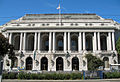
The centerpiece of the Civic Center is the City Hall, which heads the complex and takes up two city blocks on Polk Street. The section of the street in front of the building was renamed for Dr. Carlton B. Goodlett, a local African American activist. Across the street on McAllister Street is the headquarters of the Supreme Court of California. Across from that building is the Asian Art Museum, opened in 2004 in the former main branch building of the San Francisco Public Library, which moved to a newer building constructed just south of Fulton in 1995.

North of City Hall is the Phillip Burton Federal Building and United States Courthouse for the United States District Court for the Northern District of California, and State of California office buildings. This includes offices of several federal agencies, including the Federal Bureau of Investigation San Francisco Field Office. [12] East of the main Civic Center complex on nearby Mission Street, is the head courthouse of the United States Court of Appeals for the Ninth Circuit which sits across 7th from the San Francisco Federal Building complex.

Monuments

The Pioneer Monument, funded by the estate of James Lick and dedicated to Manifest Destiny, is located in the middle of Fulton Street between the Library and the Asian Art Museum. The section of Fulton Street between Hyde and Leavenworth streets was pedestrianized and re-developed into United Nations Plaza in 1975 as a monument for the United Nations and the signing of the UN Charter, when the Bay Area Rapid Transit subway was constructed under Market Street. The 2.6-acre (11,000 m2) pedestrian mall was designed by Lawrence Halprin. [13] It was rededicated in June 1995 by visiting members of the UN General Assembly as part of its 60th anniversary, and renovated and rededicated again in 2005 during the World Environment Day event. Currently, it is the site of a small farmers' market as well as a replica of a large equestrian statue of Simon Bolivar.

Culture

West of City Hall on Van Ness Avenue is the War Memorial Opera House, where the U.N. Charter was signed in 1945 and the Treaty of San Francisco was signed in 1951. Davies Symphony Hall is south of the Opera House; to its north is the War Memorial Veterans Building, which contains the Herbst Theatre. The Bill Graham Civic Auditorium and SHN Orpheum Theatre are also located in Civic Center.

Parks and open spaces

The main open space just east of City Hall is Civic Center Plaza. Despite the area's seedy reputation due to its proximity to the Tenderloin, its central location also makes it the center of many of the city's festivals and parades. Many street parades and parties are held in Civic Center Plaza, including San Francisco's Gay Pride Parade, the city's Earth Day celebration (which attracts 15,000+ people), the St. Patrick's Day parade, San Francisco's version of the Love Parade, and the San Francisco LovEvolution party.

Renovated and re-opened on February 15, 2018, the Helen Diller Civic Center Playgrounds reside on the Northeast and Southeast corners of the Civic Center Plaza. [14] The San Francisco Parks and Recreation program partnered with The Trust for Public Land to renovate the 20 year old playgrounds. [15] The playgrounds were funded by a generous $10 million donation from the Helen Diller Family Foundation. [14] [15] [16] The playgrounds serve many surrounding neighborhoods with limited open space such as the Tenderloin, Western Addition, Hayes Valley, and South of Market neighborhoods. [15]

Transit

Access to Civic Center is provided by the Civic Center Station on Market, a subway stop for both BART and the Muni Metro. The F Market historic streetcar line and many Muni bus lines also run nearby.

Education

Civic Center is the site of four famous higher education schools: Minerva Schools at KGI, the University of California, Hastings College of the Law, the private The Art Institute of California – San Francisco and The San Francisco Conservatory of Music. UC Hastings is located on the two blocks straddling Hyde between Golden Gate and McAllister. Academy of Art University owns two buildings in the neighborhood, and the buildings are used primarily for academic and administrative purposes. [17]

Other points of interest

The Fox Plaza condominium complex is also located nearby. The large art installation Firefly by Ned Kahn can be seen on the side of the San Francisco Public Utilities Commission building on Golden Gate Avenue.

In December 2010, a set of innovative wind and solar hybrid streetlamps provided by Urban Green Energy were installed [18] as part of the center's vision for sustainability.

Selected photos

SF Civic Center pano 01.jpg
270° panorama.

See also

Related Research Articles

<span class="mw-page-title-main">North Beach, San Francisco</span> Neighborhood in San Francisco, California, United States

North Beach is a neighborhood in the northeast of San Francisco adjacent to Chinatown, the Financial District, and Russian Hill. The neighborhood is San Francisco's "Little Italy" and has historically been home to a large Italian American population, largely from Northern Italy. It still has many Italian restaurants, though many other ethnic groups currently live in the neighborhood. It was also the historic center of the beatnik subculture and has become one of San Francisco's main nightlife districts as well as a residential neighborhood populated by a mix of young urban professionals, families, and Chinese immigrants.

<span class="mw-page-title-main">San Francisco City Hall</span> City Hall for the City and County of San Francisco, California

San Francisco City Hall is the seat of government for the City and County of San Francisco, California. Re-opened in 1915 in its open space area in the city's Civic Center, it is a Beaux-Arts monument to the City Beautiful movement that epitomized the high-minded American Renaissance of the 1880s to 1917. The structure's dome is taller than that of the United States Capitol by 42 feet (13 m). The present building replaced an earlier City Hall that was destroyed during the 1906 earthquake, which was two blocks from the present one.

<span class="mw-page-title-main">Hayes Valley, San Francisco</span> Neighborhood in San Francisco, California, United States

Hayes Valley is a neighborhood in the Western Addition district of San Francisco, California. It is located between the historical districts of Alamo Square and the Civic Center. Victorian, Queen Anne, and Edwardian townhouses are mixed with high-end boutiques, restaurants, and public housing complexes. The neighborhood gets its name from Hayes Street, which was named for Thomas Hayes, San Francisco's county clerk from 1853 to 1856 who also started the first Market Street Railway franchise.

The 49-Mile Scenic Drive is a designated scenic road tour highlighting much of San Francisco, California. It was created in 1938 by the San Francisco Down Town Association to showcase the city's major attractions and natural beauty during the 1939 Golden Gate International Exposition.

<span class="mw-page-title-main">Downtown San Diego</span> City center of San Diego, California, United States

Downtown San Diego is the city center of San Diego, California, the eighth largest city in the United States. In 2010, the Centre City area had a population of more than 28,000. Downtown San Diego serves as the cultural and financial center and central business district of San Diego, with more than 4,000 businesses and nine districts. The downtown area is the home of the San Diego Symphony and the San Diego Opera as well as multiple theaters and several museums. The San Diego Convention Center and Petco Park, home of the San Diego Padres, are also located downtown. Downtown San Diego houses the major local headquarters of the city, county, state, and federal governments.

<span class="mw-page-title-main">Tenderloin, San Francisco</span> Neighborhood in California, U.S.

The Tenderloin is a neighborhood in downtown San Francisco, in the flatlands on the southern slope of Nob Hill, situated between the Union Square shopping district to the northeast and the Civic Center office district to the southwest. Encompassing about 50 square blocks, it is historically bounded on the north by Geary Street, on the east by Mason Street, on the south by Market Street and on the west by Van Ness Avenue. The northern boundary with Lower Nob Hill has historically been set at Geary Street.

<span class="mw-page-title-main">Fox Plaza (San Francisco)</span> Building in San Francisco, California, USA

Fox Plaza is a 29-story building located at 1390 Market Street in the Civic Center area of San Francisco. Built in 1966, the tower stands 354 ft (108 m) on the site of the former historic Fox Theatre at 1350 Market, which was opened in June 1929 and demolished in 1963.

<span class="mw-page-title-main">Downtown Santa Ana</span> United States historic place

Downtown Santa Ana (DTSA), also called Downtown Orange County, is the city center of Santa Ana, the county seat of Orange County, California. It is the institutional center for the city of Santa Ana as well as Orange County, a retail and business hub, and has in recent years developed rapidly as a regional cultural, entertainment and culinary center for Orange County.

<span class="mw-page-title-main">San Jose City Hall</span> Seat of the municipal government of San Jose, California

San José City Hall is the seat of the municipal government of San Jose, California. Located in Downtown San Jose, it was designed by Pritzker Prize-winning architect Richard Meier in a Postmodern style. It consists of an 18-story tower, an iconic glass rotunda, and a city council chamber wing, laid out within a two-block-long public square known as San José Civic Plaza. The tower rises 285 feet (87 m) above the plaza, making it the fourth tallest building in San Jose.

<span class="mw-page-title-main">Van Ness Avenue</span> Thoroughfare in San Francisco, United States

Van Ness Avenue is a north–south thoroughfare in San Francisco, California. Originally named Marlette Street, the street was renamed Van Ness Avenue in honor of the city's sixth mayor, James Van Ness.

Oakland's Civic Center neighborhood is a residential and public building district on the east side of Oakland's Central Business District. Its borders are roughly Downtown and Harrison Street to the west, the East Lake Neighborhood and Lakeshore Avenue to the east, the Lakeside Apartments District and 14th Street to the North, and Chinatown and 11th Street to the South.

<span class="mw-page-title-main">McAllister Tower Apartments</span> Apartment skyscraper in California

McAllister Tower Apartments is a 28-story, 94 m (308 ft) residential apartment skyscraper at 100 McAllister Street in San Francisco, California. The property is owned and operated by the University of California, Hastings College of the Law. The tower includes mixed-use offices on various floors, and the Art Deco-styled "Sky Room" with a panoramic view on the 24th floor.

<span class="mw-page-title-main">50 United Nations Plaza Federal Office Building (San Francisco)</span> United States historic place

The 50 United Nations Plaza Federal Office Building is a United States federal building located on United Nations Plaza between Hyde and McAllister Streets in San Francisco, California. The 1936 Neoclassical style building, designed by Arthur Brown, Jr., is listed on the National Register of Historic Places, and is a contributing property to the San Francisco Civic Center Historic District, which is a National Historic Landmark.

<span class="mw-page-title-main">Mid-Market, San Francisco</span> Neighborhood in San Francisco, California

Mid-Market is a neighborhood and development area in San Francisco, California, bounded by Market Street to the north, 5th Street to the east, Mission Street to the south, and Van Ness Avenue to the west.

<span class="mw-page-title-main">Nob Hill, San Francisco</span> Neighborhood in San Francisco, California, United States

Nob Hill is a neighborhood of San Francisco, California, United States that is known for its numerous luxury hotels and historic mansions. Nob Hill has historically served as a center of San Francisco's upper class. Nob Hill is among the highest-income neighborhoods in the United States, as well as one of the most desirable and expensive real estate markets in the country.

<span class="mw-page-title-main">Civic Center Plaza</span> Plaza in San Francisco, United States

Civic Center Plaza, also known as Joseph Alioto Piazza, is the 4.53-acre (1.83 ha) plaza immediately east of San Francisco City Hall in Civic Center, San Francisco, in the U.S. state of California. Civic Center Plaza occupies two blocks bounded by McAllister, Larkin, Grove, and Carlton B. Goodlett, divided into a north block and south block by the former alignment of Fulton Street. The block north of Fulton is built over a three-story parking garage ; the block south of Fulton lies over a former exhibition space, Brooks Hall.

<span class="mw-page-title-main">United Nations Plaza (San Francisco)</span> Plaza in San Franciscos Civic Center

United Nations Plaza is a 2.6-acre (1.1 ha) plaza located on the former alignments of Fulton and Leavenworth Streets—in the block bounded by Market, Hyde, McAllister, and 7th Street—in the Civic Center of San Francisco, California. It is located 14 mi (0.40 km) east of City Hall and is connected to it by the Fulton Mall and Civic Center Plaza. Public transit access is provided by the BART and Muni Metro stops at the Civic Center/UN Plaza station, which has a station entrance within the plaza itself.

<span class="mw-page-title-main">Brooks Hall</span> Disused event venue in San Francisco, California

Brooks Hall is a disused 90,000 sq ft (8,400 m2) event space underneath the southern half of Civic Center Plaza in San Francisco; a parking garage occupies the space under the northern half.

<span class="mw-page-title-main">Uptown Tenderloin Historic District</span> Historic district in San Francisco County, California, U.S.

The Uptown Tenderloin Historic District is a historic district located in the Tederloin neighborhood of San Francisco, California, U.S.. It has 408 contributing buildings and covers roughly a 33-city block radius in downtown San Francisco. The Uptown Tenderloin Historic District was listed on the National Register of Historic Places on February 5, 2009, for architecture and social history.

References

  1. 1 2 "Statewide Database". UC Regents. Archived from the original on February 1, 2015. Retrieved December 8, 2014.
  2. "California's 11th Congressional District - Representatives & District Map". Civic Impulse, LLC.
  3. 1 2 3 "Civic Center neighborhood in San Francisco, California (CA), 94102, 94109 subdivision profile - real estate, apartments, condos, homes, community, population, jobs, income, streets".
  4. 1 2 Charleton, James P. (November 9, 1984). "San Francisco Civic Center" (pdf). National Register of Historic Places – Inventory Nomination Form. National Park Service . Retrieved 20 May 2012.
  5. 1 2 3 "National Register Information System". National Register of Historic Places . National Park Service. July 9, 2010.
  6. 1 2 "San Francisco Civic Center". National Historic Landmark Quicklinks. National Park Service. Archived from the original on 8 October 2012. Retrieved 20 March 2012.
  7. 1 2 Issel, William; Cherny, Robert (1986). San Francisco 1865–1932: Politics, Power, and Urban Development. Berkeley, California: University of California Press. pp.  170–171. ISBN   0-520-05263-3 . Retrieved 26 October 2018.
  8. Burnham, Daniel H.; Bennett, Edward H. (September 1905). O'Day, Edward F. (ed.). Report on a plan for San Francisco (Report). Association for the Improvement and Adornment of San Francisco. Retrieved 31 January 2017.
  9. 1 2 3 4 Civic Center Proposal (PDF) (Report). City and County of San Francisco, Office of Mayor Dianne Feinstein. November 1987. Retrieved 26 October 2018.
  10. 1 2 3 4 "Civic Center at San Francisco". Engineering Record: 489. October 31, 1914. Retrieved 26 October 2018.
  11. "Now for New City Hall". San Francisco Call. 5 April 1913. Retrieved 26 October 2018.
  12. "San Francisco Division." Federal Bureau of Investigation. Retrieved on June 9, 2015. "450 Golden Gate Avenue, 13th Floor San Francisco, CA 94102-9523"
  13. 2.6 acres, 1975, part of BART construction, Halprin as designer Archived 2007-09-27 at the Wayback Machine
  14. 1 2 "$10 million playgrounds give downtown SF kids a safe place to frolic". SFChronicle.com. 2018-02-16. Retrieved 2018-08-01.
  15. 1 2 3 "Helen Diller Playgrounds at Civic Center Improvements | San Francisco Recreation and Park". sfrecpark.org. Retrieved 2018-08-01.
  16. "Helen Diller Civic Center Playgrounds". The Trust for Public Land. Retrieved 2018-08-01.
  17. "Academy of Art University Campus Map" (PDF). academyart.edu. Academy of Art University . Retrieved 23 November 2016.
  18. Hybrid Street Lamp Hits San Francisco Archived 2010-12-20 at the Wayback Machine