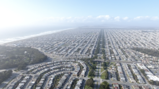
San Francisco, officially the City and County of San Francisco, is the commercial, financial, and cultural center of Northern California. With a population of 808,437 residents as of 2022, San Francisco is the fourth most populous city in the U.S. state of California behind Los Angeles, San Diego, and San Jose. The city covers a land area of 46.9 square miles at the upper end of the San Francisco Peninsula, making it the second-most densely populated major U.S. city behind New York City and the fifth-most densely populated U.S. county, behind four of New York City's boroughs. Among the 92 U.S. cities proper with over 250,000 residents, San Francisco is ranked first by per capita income and sixth by aggregate income as of 2022.As of 2023, the San Jose–San Francisco–Oakland, CA CSA is the 5th largest in the nation, with an approximate population of over 9,001,024.

The Presidio of San Francisco is a park and former U.S. Army post on the northern tip of the San Francisco Peninsula in San Francisco, California, and is part of the Golden Gate National Recreation Area.

Treasure Island is an artificial island in San Francisco Bay, and a neighborhood in the City and County of San Francisco. Built in 1936–37 for the 1939 Golden Gate International Exposition, the island was named by Clyde Milner Vandeburg, part of the Fair's public relations team. Its World's Fair site is a California Historical Landmark. Buildings there have been listed on the National Register of Historic Places, and the historical Naval Station Treasure Island, an auxiliary air facility, are designated in the Geographic Names Information System. Treasure Island is connected to Yerba Buena Island, another (natural) auxiliary island of San Francisco, by a causeway, creating access to Interstate 80.

The 1989 Loma Prieta earthquake occurred on California's Central Coast on October 17 at local time. The shock was centered in The Forest of Nisene Marks State Park in Santa Cruz County, approximately 10 mi (16 km) northeast of Santa Cruz on a section of the San Andreas Fault System and was named for the nearby Loma Prieta Peak in the Santa Cruz Mountains. With an magnitude of 6.9 and a maximum Modified Mercalli intensity of IX (Violent), the shock was responsible for 63 deaths and 3,757 injuries. The Loma Prieta segment of the San Andreas Fault System had been relatively inactive since the 1906 San Francisco earthquake until two moderate foreshocks occurred in June 1988 and again in August 1989.

The Richmond District is a neighborhood in the northwest corner of San Francisco, California, developed initially in the late 19th century. It is sometimes confused with the city of Richmond, which is 20 miles (32 km) northeast of San Francisco.

The Sunset District is a neighborhood located in the southwest quadrant of San Francisco, California, United States.

Lombard Street is an east–west street in San Francisco, California, that is famous for a steep, one-block section with eight hairpin turns. The street stretches from The Presidio east to The Embarcadero. Most of Lombard Street's western segment is a major thoroughfare designated as part of U.S. Route 101. The famous one-block section, claimed to be "the crookedest street in the world", is located along the eastern segment in the Russian Hill neighborhood. It is a major tourist attraction, receiving around two million visitors per year and up to 17,000 per day on busy summer weekends, as of 2015.

Bernal Heights is a residential neighborhood in southeastern San Francisco, California. The prominent Bernal Heights hill overlooks the San Francisco skyline and features a microwave transmission tower. The nearby Sutro Tower can be seen from the Bernal Heights neighborhood.

Russian Hill is a neighborhood of San Francisco, California. It is named after one of San Francisco's 44 hills, and one of its original "Seven Hills".

Crocker-Amazon is a neighborhood in San Francisco that borders the Excelsior District. Crocker-Amazon covers the area south of Mission Street and Geneva Avenue, extending toward suburban Daly City. The neighborhood is adjacent to Crocker-Amazon Park, named after the Charles Crocker land holdings that once made up the area, and Amazon Avenue in the Excelsior. The winding streets of the neighborhood straddle the border between San Francisco and Daly City and largely blend in with the adjacent Daly City neighborhoods of Crocker and Southern Hills.

State Route 480 was a state highway in San Francisco, California, United States, consisting of the elevated double-decker Embarcadero Freeway, the partly elevated Doyle Drive approach to the Golden Gate Bridge and the proposed and unbuilt section in between. The unbuilt section from Doyle Drive to Van Ness Avenue was to have been called the Golden Gate Freeway and the Embarcadero Freeway as originally planned would have extended from Van Ness along the north side of Bay Street and then along the Embarcadero to the San Francisco-Oakland Bay Bridge.

Pacific Heights is a neighborhood in San Francisco, California, United States. It has panoramic views of the Golden Gate Bridge, San Francisco Bay, the Palace of Fine Arts, Alcatraz, and the Presidio.

West Oakland is a neighborhood situated in the northwestern corner of Oakland, California, United States, situated west of Downtown Oakland, south of Emeryville, and north of Alameda. The neighborhood is located along the waterfront at the Port of Oakland and at the eastern end of the San Francisco–Oakland Bay Bridge. It lies at an elevation of 13 feet.

The Marina Green in San Francisco, California, is a 74-acre (300,000 m2) expanse of grass between Fort Mason and the Presidio. It is adjacent to San Francisco Bay, and this location provides good views of the Golden Gate Bridge, Angel Island, Alcatraz Island, and parts of Marin County. Houses built mostly in the 1920s and 1930s line Marina Boulevard, the southern boundary of the Marina Green. Many of these houses have large bay windows, and Herb Caen, the late San Francisco newspaper columnist, often made references to the immaculate furnishings behind these windows. In the past, a railroad track along the southern edge of the Marina Green allowed the San Francisco Belt Railroad to serve the Presidio. Adjacent to the Marina Green is a marina, home to the St. Francis Yacht Club and the Golden Gate Yacht Club. The San Francisco Bay Trail runs through the green.
The 49-Mile Scenic Drive is a designated scenic road tour highlighting much of San Francisco, California. It was created in 1938 by the San Francisco Down Town Association to showcase the city's major attractions and natural beauty during the 1939 Golden Gate International Exposition.

Rincon Hill is a neighborhood in San Francisco, California. It is one of San Francisco's many hills, and one of its original "Seven Hills". The relatively compact neighborhood is bounded by Folsom Street to the north, the Embarcadero to the east, Bryant Street on the south, and Essex Street to the west. Named after Rincon Point that formerly extended into the bay there, Rincon Hill is located just south of the Transbay development area, part of the greater South of Market area. The hill is about 100 feet tall.

Sand boils, sand volcanoes, or sand blows occur when water under pressure wells up through a bed of sand. The water looks like it is boiling up from the bed of sand, hence the name.

Established in 1917, the Presidio Fire Department provides primary emergency response to the Presidio of San Francisco.

Phoenix is a fireboat owned by State of California and operated by the city of San Francisco in the San Francisco Bay since 1955. Phoenix is known for helping to save Marina District buildings from further destruction by fire following the 1989 Loma Prieta earthquake. Her worthy assistance resulted in a second vintage fireboat obtained for the city. Both Guardian and Phoenix are based at Firehouse No. 35 at Pier 22½ of the Port of San Francisco. Phoenix often leads parades of ships, and takes part in welcoming ceremonies.


