
Anza Vista is a neighborhood in the Western Addition district of San Francisco, California. [1] It is named after Juan Bautista de Anza, the first Spanish explorer to reach San Francisco.
Anza Vista is a neighborhood in the Western Addition district of San Francisco, California. [1] It is named after Juan Bautista de Anza, the first Spanish explorer to reach San Francisco.

It sits atop the former location of the San Francisco Calvary Cemetery. Graves in this cemetery, along with all graves in San Francisco, were moved in the 1930s and 1940s to Colma after burials in San Francisco were banned in 1902 at all but two cemeteries to increase available real estate. [2]
Anza Vista is located between Geary Boulevard to the north, Turk Street to the south, Masonic Avenue to the west and Divisadero Street to the east. Some of the surrounding areas between The Presidio, Golden Gate Park, the Panhandle, and the Western Addition may sometimes be referred to as part of the Anza Vista neighborhood.
A Target anchored shopping center, The City Center, is located on Geary Boulevard and Masonic Avenue in the north-western corner of the neighborhood.
Anza Vista is also the location of a Kaiser Permanente hospital on Geary Boulevard at St. Joseph's Avenue, and the Raoul Wallenberg Traditional High School on Nido Avenue.

Cupertino is a city in Santa Clara County, California, United States, directly west of San Jose on the western edge of the Santa Clara Valley with portions extending into the foothills of the Santa Cruz Mountains. The population was 60,381 as of the 2020 census. It is known for being the home of Apple Inc., headquartered at Apple Park.

The Richmond District is a neighborhood in the northwest corner of San Francisco, California, developed initially in the late 19th century. It is sometimes confused with the city of Richmond, which is 20 miles (32 km) northeast of San Francisco.
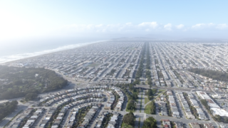
The Sunset District is a neighborhood located in the southwest quadrant of San Francisco, California, United States.

The Duboce Triangle is a neighborhood of San Francisco, California, located below Buena Vista Park and between the neighborhoods of the Castro/Eureka Valley, the Mission District, and the Lower Haight.

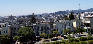
Hayes Valley is a neighborhood in the Western Addition district of San Francisco, California. It is located between the historical districts of Alamo Square and the Civic Center. Victorian, Queen Anne, and Edwardian townhouses are mixed with high-end boutiques, restaurants, and public housing complexes. The neighborhood gets its name from Hayes Street, which was named for Thomas Hayes, San Francisco's county clerk from 1853 to 1856 who also started the first Market Street Railway franchise.
The Western Addition is a district in San Francisco, California, United States.

The Fillmore District is a historical neighborhood in San Francisco located to the southwest of Nob Hill, west of Market Street and north of the Mission District. It has been given various nicknames such as “the Moe” or “the Fill”. The Fillmore District began to rise to prominence after the 1906 San Francisco earthquake. As a result of not being affected by the earthquake itself nor the large fires that ensued, it quickly became one of the major commercial and cultural centers of the city.

The San Francisco Public Library is the public library system of the city and county of San Francisco. The Main Library is located at Civic Center, at 100 Larkin Street. The library system has won several awards, such as Library Journal's Library of the Year award in 2018. The library is well-funded due to the city's dedicated Library Preservation Fund that was established by a 1994 ballot measure, which was subsequently renewed until 2022 by a ballot measure in 2007.

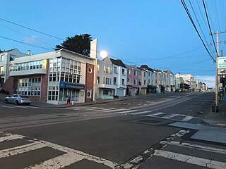
Geary Boulevard is a major east–west 5.8-mile-long (9 km) thoroughfare in San Francisco, California, United States, beginning downtown at Market Street near Market Street's intersection with Kearny Street, and running westbound through downtown, the Civic Center area, the Western Addition, and running for most of its length through the predominantly residential Richmond District. Geary Boulevard terminates near Sutro Heights Park at 48th Avenue, close to the Cliff House above Ocean Beach at the Pacific Ocean. At 42nd Avenue, Geary intersects with Point Lobos Avenue, which takes through traffic to the Cliff House, Ocean Beach and the Great Highway. It is a major commercial artery through the Richmond District; it is lined with stores and restaurants, many of them catering to the various immigrant groups who live in the area. The boulevard borders Japantown between Fillmore and Laguna Streets.

Maxwell Park is a neighborhood in Oakland, California located in the foothills of the city. It is geographically bordered by MacArthur Boulevard, High Street, Trask Street, Foothill Boulevard, and 55th Avenue and is adjacent to Mills College, I-580, Brookdale Park, and the Fairfax neighborhood. It lies at an elevation of from 138 feet to its highest point of 266 feet on Knowland Ave.

Octavia Boulevard is a major street in San Francisco, California that replaced the Hayes Valley portion of the damaged two-level Central Freeway. Once a portion of Octavia Street alongside shadowy, fenced-off land beneath the elevated U.S. Route 101 roadway, Octavia Boulevard was redeveloped and redesigned upon the suggestion of Mark Jolles of San Francisco.

Cathedral Hill is a neighborhood and a hill, in the Western Addition district of San Francisco, California.
The Parkside is a neighborhood in the western part of San Francisco, California, usually considered to be part of the Sunset District. It is located in the southern part of the Avenues south of Quintara and north of Sloat Boulevard.
San Antonio is a large district in Oakland, California, encompassing the land east of Lake Merritt to Sausal Creek. It is one of the most diverse areas of the city. It takes its name from Rancho San Antonio, the name of the land as granted to Luís María Peralta by the last Spanish governor of California.
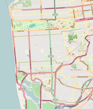
19th Avenue is a north-south city street in San Francisco, California. It consists of two non-contiguous segments that are separated by Golden Gate Park. The southern segment is a six-lane arterial thoroughfare, mostly signed as part of California State Route 1, that goes through the southwestern part of the city. The non-contiguous northern segment is primarily a residential street through the Richmond District.

Laurel Heights is a neighborhood of San Francisco, California. It is located to the south of the Presidio of San Francisco and east of the Richmond District. It is bordered by Geary Boulevard and the University of San Francisco campus to the south, Arguello Boulevard to the west, California Street to the north and Presidio Avenue to the east.
Ewing Field was a baseball park in San Francisco, California. It served as the home of the San Francisco Seals of the Pacific Coast League for a single season, 1914.

Lone Mountain Cemetery was a complex of cemeteries in the Lone Mountain neighborhood of San Francisco, California, United States on the land bounded by the present-day California Street, Geary Boulevard, Parker Avenue, and Presidio Avenue. Opened 1854, it eventually comprised Laurel Hill Cemetery, Calvary Cemetery, the Masonic Cemetery, and Odd Fellows Cemetery.
| Downtown |  | |
|---|---|---|
| North of Downtown | ||
| Outside Lands | ||
| Western Addition | ||
| Southern | ||
Coordinates: 37°46′51″N122°26′35″W / 37.78087°N 122.44319°W