Alamo Square, San Francisco

Last updated

Alamo Square
Alamo Square with Painted Ladies, SF, CA, jjron 26.03.2012.jpg
Looking across Alamo Square Park towards the famous "Painted Ladies" and city skyline
Location map San Francisco Central.png
Red pog.svg
Alamo Square
Location within Central San Francisco
USA California location map.svg
Red pog.svg
Alamo Square
Alamo Square (California)
Usa edcp location map.svg
Red pog.svg
Alamo Square
Alamo Square (the United States)
Coordinates: 37°46′35″N122°26′05″W / 37.776384°N 122.434709°W / 37.776384; -122.434709
Country United States
State California
City and county San Francisco
Government
   Supervisor Dean Preston
   Assemblymember Matt Haney (D) [1]
   State senator Scott Wiener (D) [1]
   U. S. rep. Nancy Pelosi (D) [2]
Area
[3]
  Total0.463 sq mi (1.20 km2)
  Land0.463 sq mi (1.20 km2)
Population
 (2008) [3]
  Total5,617
  Density31,059/sq mi (11,992/km2)
Time zone UTC-8 (Pacific)
  Summer (DST) UTC-7 (PDT)
ZIP codes
94115, 94117
Area codes 415/628
[3]

Alamo Square is a residential neighborhood in San Francisco, California with a park of the same name. Located in the Western Addition, its boundaries are Buchanan Street on the east, Turk Street on the north, Baker Street on the west, and Page Street Street on the south.

Contents

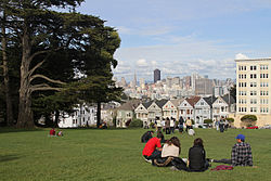
Alamo Square Park, the neighborhood's focal point and namesake, consists of four city blocks at the top of a hill overlooking much of downtown San Francisco, with a number of large and architecturally distinctive mansions along the perimeter, including the "Painted Ladies", a well-known postcard motif. The park is bordered by Hayes Street to the south, Steiner Street to the east, Fulton Street to the north, and Scott Street to the west. Named after the lone cottonwood tree ("álamo" in Spanish), Alamo Hill, was a watering hole on the horseback trail from Mission Dolores to the Presidio in the 1800s. In 1856, Mayor James Van Ness created a 12.7 acres (5.1 ha) park surrounding the watering hole, creating "Alamo Square". [4]

Attractions and characteristics

Alamo Square Park includes a playground and a tennis court, and is frequented by neighbors, tourists, and dog owners. On a clear day, the Transamerica Pyramid building and the tops of the Golden Gate Bridge and Bay Bridge can be seen from the park's center. The San Francisco City Hall can be seen directly down Fulton Street. The area is part of the city's fifth Supervisorial district and is served by several Muni bus lines, including the 5, 21, 22, and 24. In 2016 it was closed for a $4.3 million renovation lasting seven months. [5]

Architecture

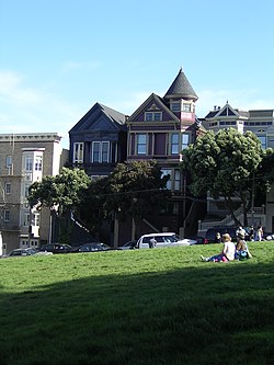
The Alamo Square neighborhood is characterized by Victorian architecture that was left largely untouched by the urban renewal projects in other parts of the Western Addition. The Alamo Square area contains the second largest concentration of homes over 10,000 square feet (930 m2) in San Francisco, after the Pacific Heights neighborhood. [6]

Alamo Square from the air Alamo Square, San Francisco from the air in May 2010.jpg
Alamo Square from the air

A row of Victorian houses facing the park on Steiner Street, known as the "Painted Ladies", are often shown in the foreground of panoramic pictures of the city's downtown area. A number of movies, television shows and commercials have been filmed in or around Alamo Square. The park features heavily in the 1978 horror film The Invasion of the Body Snatchers , and the 2012 romantic comedy The Five-Year Engagement . [7] The opening sequence of the American sitcom Full House (1987–1995) features a romp in Alamo Square Park with the famous row of Victorians in the background. [8]

Alamo Square facing south Alamo square19.JPG
Alamo Square facing south

There are many architecturally significant mansions on the perimeter of the park, including the William Westerfeld House, the Archbishop's Mansion, the residences of the Russian and German Imperial consuls in the early 1900s, and the mansions on the block diagonally across from the Painted Ladies. In 1984, the Alamo Square Historic District was created by the Board of Supervisors, stating: [9]

The Alamo Square Historic District is significant as a continuum of distinguished residential architecture by distinguished architects spanning the period from the 1870s to the 1920s. The towered Westerfield House, the renowned "Postcard Row" with its background of the downtown skyline, and the neighboring streetscapes are as identified worldwide with San Francisco as the cable cars and Coit Tower. With a variety of architectural styles, the District is unified in its residential character, relatively small scale, construction type, materials (principally wood), intense ornamentation (especially at entry and cornice), and use of basements and retaining walls to adjust for hillside sites... With a high degree of integrity to its original designs, the District clearly serves as a visual reminder of how businessmen lived two to four generations ago.

Demographics

The demographics of the neighborhood are characteristic of other urban neighborhoods that have undergone gentrification: many young people and upper-middle-class homeowners, in addition to a diverse older population. Divisadero Street, which divides Alamo Square from North Panhandle, is home to a number of small businesses including a growing collection of hip and popular restaurants and bars, catering to the young tech professionals who are contributing to the booming San Francisco startup economy, and who value Alamo Square's weather, conveniently central location and easy access to transportation options.

Efforts on the part of Alamo Square and North Panhandle residents and merchants have led to restrictions on chain stores on the corridor.

Neighborhood groups include the Alamo Square Neighborhood Association and the Haight-Divisadero Neighborhood Merchants Association.

Notable residents

Author Alice Walker lived in one of the "Painted Lady" Victorians across from Alamo Square park up to the mid-1990s. [8]

See also

Related Research Articles

<span class="mw-page-title-main">Richmond District, San Francisco</span> Neighborhood in San Francisco, California, United States

The Richmond District is a neighborhood in the northwest corner of San Francisco, California, developed initially in the late 19th century. It is sometimes confused with the city of Richmond, which is 20 miles (32 km) northeast of San Francisco.

<span class="mw-page-title-main">Haight-Ashbury</span> Neighborhood in San Francisco, California, United States

Haight-Ashbury is a district of San Francisco, California, named for the intersection of Haight and Ashbury streets. It is also called The Haight and The Upper Haight. The neighborhood is known as one of the main centers of the counterculture of the 1960s.

<span class="mw-page-title-main">Terraced house</span> Form of medium-density housing

A terrace, terraced house (UK), or townhouse (US) is a kind of medium-density housing that first started in 16th century Europe with a row of joined houses sharing side walls. In the United States and Canada these are sometimes known as row houses or row homes.

<span class="mw-page-title-main">Victorian architecture</span> Series of architectural revival styles

Victorian architecture is a series of architectural revival styles in the mid-to-late 19th century. Victorian refers to the reign of Queen Victoria (1837–1901), called the Victorian era, during which period the styles known as Victorian were used in construction. However, many elements of what is typically termed "Victorian" architecture did not become popular until later in Victoria's reign, roughly from 1850 and later. The styles often included interpretations and eclectic revivals of historic styles (see Historicism). The name represents the British and French custom of naming architectural styles for a reigning monarch. Within this naming and classification scheme, it followed Georgian architecture and later Regency architecture and was succeeded by Edwardian architecture.

<span class="mw-page-title-main">Painted ladies</span> In American architecture, repainted Victorian and Edwardian houses

In American architecture, painted ladies are Victorian and Edwardian houses and buildings repainted, starting in the 1960s, in three or more colors that embellish or enhance their architectural details. The term was first used for San Francisco Victorian houses by Elizabeth Pomada and Michael Larsen in their 1978 book Painted Ladies: San Francisco's Resplendent Victorians. Although polychrome decoration was common in the Victorian era, the colors used on these houses are not based on historical precedent.

<span class="mw-page-title-main">Duboce Triangle, San Francisco</span> Neighborhood in San Francisco, California, United States

The Duboce Triangle is a neighborhood of San Francisco, California, located below Buena Vista Park and between the neighborhoods of the Castro/Eureka Valley, the Mission District, and the Lower Haight.

<span class="mw-page-title-main">Hayes Valley, San Francisco</span> Neighborhood in San Francisco, California, United States

Hayes Valley is a neighborhood in the Western Addition district of San Francisco, California. It is located between the historical districts of Alamo Square and the Civic Center. Victorian, Queen Anne, and Edwardian townhouses are mixed with high-end boutiques, restaurants, and public housing complexes. The neighborhood gets its name from Hayes Street, which was named for Thomas Hayes, San Francisco's county clerk from 1853 to 1856 who also started the first Market Street Railway franchise.

<span class="mw-page-title-main">Western Addition, San Francisco</span> Neighborhood of San Francisco in California, United States

The Western Addition is a district in San Francisco, California, United States.

<span class="mw-page-title-main">Panhandle (San Francisco)</span> Linear park in the California city

The Panhandle is a public park in San Francisco, California, so named because it forms a panhandle with Golden Gate Park. It is long and narrow, being three-quarters of a mile long and just one block wide. Fell and Oak Streets border it to the north and south, Baker Street to the east, and to the west Stanyan Street which separates the smaller Panhandle from the much larger Golden Gate Park. The Panhandle is bisected by Masonic Avenue, which runs north to south and cuts through the middle of the park. In its westernmost block, Oak and Fell Streets angle across the Panhandle, converge with one another, and continue west of Stanyan as John F. Kennedy Drive and Kezar Drive.

The Lower Haight is a neighborhood, sometimes referred to as Haight–Fillmore, in San Francisco, California.

<span class="mw-page-title-main">Pacific Heights, San Francisco</span> Neighborhood in San Francisco, California, United States

Pacific Heights is a neighborhood in San Francisco, California, United States. It has panoramic views of the Golden Gate Bridge, San Francisco Bay, the Palace of Fine Arts, Alcatraz, and the Presidio.

<span class="mw-page-title-main">Octavia Boulevard</span> Major road in San Francisco

Octavia Boulevard is a major street in San Francisco, California, that replaced the Hayes Valley portion of the damaged two-level Central Freeway. Once a portion of Octavia Street alongside shadowy, fenced-off land beneath the elevated U.S. Route 101 roadway, Octavia Boulevard was redeveloped and redesigned upon the suggestion of Mark Jolles of San Francisco.

<span class="mw-page-title-main">Rincon Hill, San Francisco</span> Neighborhood of San Francisco

Rincon Hill is a neighborhood in San Francisco, California. It is one of San Francisco's many hills, and one of its original "Seven Hills". The relatively compact neighborhood is bounded by Folsom Street to the north, the Embarcadero to the east, Bryant Street on the south, and Essex Street to the west. Named after Rincon Point that formerly extended into the bay there, Rincon Hill is located just south of the Transbay development area, part of the greater South of Market area. The hill is about 100 feet tall.

<span class="mw-page-title-main">The Wiggle</span> Bycicle route in San Francisco

The Wiggle is a 1-mile (1.6 km) zig-zagging bicycle route from Market Street to Golden Gate Park in San Francisco, California, that minimizes hilly inclines for bicycle riders. Rising 120 feet (37 m), The Wiggle inclines average 3% and never exceed 6%. The path generally follows the historical route of the long since paved-over Sans Souci Valley watercourse, winding through the Lower Haight neighborhood toward the Panhandle section of Golden Gate Park.

Albert Lincoln Farr was an American residential architect, who designed homes in the Craftsman and Georgian styles.

The city of San Antonio in the U.S. state of Texas is composed of a number of neighborhoods and districts, spreading out surrounding the central Downtown Area.

<span class="mw-page-title-main">Neighborhoods of Davenport, Iowa</span>

The city of Davenport, Iowa, United States has neighborhoods dating back to the 1840s. The Davenport Plan and Zoning Commission divided the city into five areas: downtown, central, east end, near north, and northwest and west end. The neighborhoods contain many architectural designs, including Victorian, Queen Anne, and Tudor Revival. Many of the original neighborhoods were first inhabited by German settlers.

<span class="mw-page-title-main">Architecture of San Francisco</span>

The architecture of San Francisco is not so much known for defining a particular architectural style; rather, with its interesting and challenging variations in geography and topology and tumultuous history, San Francisco is known worldwide for its particularly eclectic mix of Victorian and modern architecture. Bay windows were identified as a defining characteristic of San Francisco architecture in a 2012 study that had a machine learning algorithm examine a random sample of 25,000 photos of cities from Google Street View.

<span class="mw-page-title-main">Neighborhoods in Springfield, Massachusetts</span>

The City of Springfield, Massachusetts, has 19 distinct neighborhoods. Many feature subdivisions known by other names, such as The X, Hungry Hill, and Mason Square. Springfield's neighborhoods fan out north, south, and east, from its original, colonial settlement in what is now Metro Center.

References

  1. 1 2 "Statewide Database". UC Regents. Archived from the original on February 1, 2015. Retrieved December 9, 2014.
  2. "California's 11th Congressional District - Representatives & District Map". Civic Impulse, LLC.
  3. 1 2 3 "Western Addition neighborhood in San Francisco, California, 94102, 94109, 94115, 94117 detailed profile". City-Data. Retrieved January 25, 2011.
  4. "Alamo Square". San Francisco Parks Alliance. May 10, 2012. Retrieved February 29, 2016.
  5. "Contentious affordable-housing measure passed by S.F. supervisors". February 3, 2016. Retrieved September 28, 2016.
  6. "Alamo Square". San Francisco Premier Homes. Retrieved January 28, 2023.
  7. Chamings, Andrew Wallace. 2013. The Lower Haight in Film Archived 2013-05-02 at the Wayback Machine
  8. 1 2 Sam Whiting (February 19, 2010). "Largest of S.F.'s Painted Ladies up for sale". The San Francisco Chronicle. Retrieved January 25, 2011.
  9. "Article 10, San Francisco Planning Code, Appendix E".