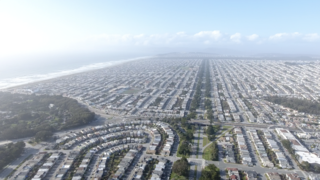
The Sunset District is a neighborhood located in the southwest quadrant of San Francisco, California, United States.

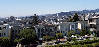
Noe Valley is a neighborhood in the central part of San Francisco, California. It is named for Don José de Jesús Noé, noted 19th-century Californio statesman and ranchero, who owned much of the area and served as mayor.
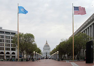
The Civic Center in San Francisco, California, is an area located a few blocks north of the intersection of Market Street and Van Ness Avenue that contains many of the city's largest government and cultural institutions. It has two large plazas and a number of buildings in classical architectural style. The Bill Graham Civic Auditorium, the United Nations Charter was signed in the Veterans Building's Herbst Theatre in 1945, leading to the creation of the United Nations. It is also where the 1951 Treaty of San Francisco was signed. The San Francisco Civic Center was designated a National Historic Landmark in 1987 and listed in the National Register of Historic Places on October 10, 1978.

Bernal Heights is a residential neighborhood in southeastern San Francisco, California. The prominent Bernal Heights hill overlooks the San Francisco skyline and features a microwave transmission tower. The nearby Sutro Tower can be seen from the Bernal Heights neighborhood.

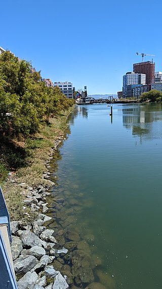
The Embarcadero is the eastern waterfront of Port of San Francisco and a major roadway in San Francisco, California. It was constructed on reclaimed land along a three mile long engineered seawall, from which piers extend into the bay. It derives its name from the Spanish verb embarcar, meaning "to embark"; embarcadero itself means "the place to embark." The Central Embarcadero Piers Historic District was added to the National Register of Historic Places on November 20, 2002.

Alamo Square is a residential neighborhood in San Francisco, California with a park of the same name. Located in the Western Addition, its boundaries are Buchanan Street on the east, Turk Street on the north, Baker Street on the west, and Page Street Street on the south.
The Western Addition is a district in San Francisco, California, United States.
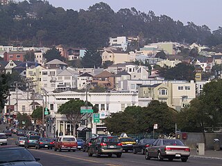
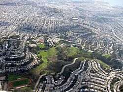
Glen Park is a residential neighborhood in San Francisco, California, located south of Twin Peaks and adjacent to Glen Canyon Park.
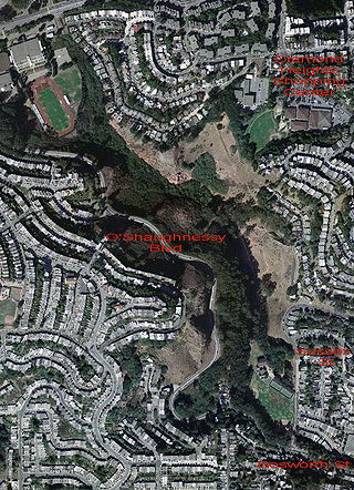
Glen Canyon Park is a city park in San Francisco, California. It occupies about 70 acres (28 ha) along a deep canyon adjacent to the Glen Park, Diamond Heights, and Miraloma Park neighborhoods. O'Shaughnessy Hollow is a rugged, undeveloped 3.6 acres (1.5 ha) tract of parkland that lies immediately to the west and may be considered an extension of Glen Canyon Park.

Crocker-Amazon is a neighborhood in San Francisco that borders the Excelsior District. Crocker-Amazon covers the area south of Mission Street and Geneva Avenue, extending toward suburban Daly City. The neighborhood is adjacent to Crocker-Amazon Park, named after the Charles Crocker land holdings that once made up the area, and Amazon Avenue in the Excelsior. The winding streets of the neighborhood straddle the border between San Francisco and Daly City and largely blend in with the adjacent Daly City neighborhoods of Crocker and Southern Hills.
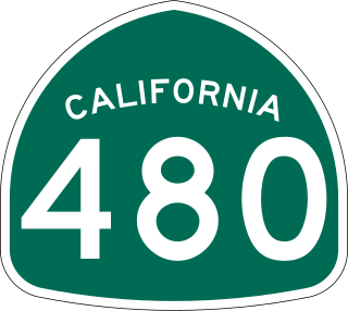
State Route 480 was a state highway in San Francisco, California, United States, consisting of the elevated double-decker Embarcadero Freeway, the partly elevated Doyle Drive approach to the Golden Gate Bridge and the proposed and unbuilt section in between. The unbuilt section from Doyle Drive to Van Ness Avenue was to have been called the Golden Gate Freeway and the Embarcadero Freeway as originally planned would have extended from Van Ness along the north side of Bay Street and then along the Embarcadero to the San Francisco-Oakland Bay Bridge.

The Fillmore District is a historical neighborhood in San Francisco located to the southwest of Nob Hill, west of Market Street and north of the Mission District. The Fillmore District began to rise to prominence after the 1906 San Francisco earthquake. As a result of not being affected by the earthquake itself nor the large fires that ensued, it quickly became one of the major commercial and cultural centers of the city.
City Heights is a dense urban community in central San Diego, California, known for its ethnic diversity. The area was previously known as East San Diego. City Heights is located south of Mission Valley and northeast of Balboa Park.
Mission Bay is a 303-acre (123 ha) neighborhood on the east side of San Francisco, California. It is bordered by China Basin to the north, Dogpatch to the south, and San Francisco Bay to the east. Originally an industrial district, it underwent development fueled by the construction of the UCSF Mission Bay campus, and is currently in the final stages of development and construction. It is the site of the Chase Center and Uber's headquarters.

Octavia Boulevard is a major street in San Francisco, California, United States, that replaced the Hayes Valley portion of the damaged two-level Central Freeway. Once a portion of Octavia Street alongside shadowy, fenced-off land beneath the elevated U.S. Route 101 roadway, Octavia Boulevard was redeveloped and redesigned upon the recommendation of a "Central Freeway" planning committee representing a broad array of neighborhoods, including the surrounding Hayes Valley and Western Addition, the Richmond District, Pacific Heights and the Sunset District with representatives appointed by Mayor Willie Brown and the Board of Supervisors and led by the Planning Department of San Francisco. Elements of the San Francisco General Plan were consulted for issues such as urban design, transportation mobility and congestion management, community safety and historic preservation, along with the evaluation of the impacts following the recent removal (1991) of the elevated Embarcadero Freeway and the revitalization of the Embarcadero as a surface boulevard complemented by an extension of the Muni Metro light-rail transit subway.

Parkmerced is a neighborhood in San Francisco, California. It was designed by architects Leonard Schultze and Thomas Dolliver Church in the early 1940s. Parkmerced is the second-largest single-owner neighborhood of apartment blocks west of the Mississippi River after Park La Brea in Los Angeles. It was a planned neighborhood of high-rise apartment towers and low-rise garden apartments in southwestern San Francisco for middle-income tenants.

Visitacion Valley, colloquially referred to as Viz Valley, is a neighborhood located in the southeastern quadrant of San Francisco, California.

Nob Hill is a neighborhood in Albuquerque, New Mexico, United States, consisting of a commercial district along Central Avenue and surrounding residential areas. Located just east of the University of New Mexico, the neighborhood was developed between about 1925 and 1950 and has since become a popular tourist and shopping destination. Known for its eclectic mix of mostly locally owned businesses, Nob Hill has been described as "the heart of Albuquerque's Route 66 culture and also its hippest, funkiest retail and entertainment district". The neighborhood is named after Nob Hill in San Francisco, California.

Myrna Melgar is an American politician currently serving as a member of the San Francisco Board of Supervisors for District 7 since January 8, 2021. Melgar is the first woman elected to represent District 7. Additionally, she is the first Jewish Latina to serve on the Board of Supervisors after the implementation of District elections in 2004.