West Portal, San Francisco

Last updated
West Portal
Foggy day in West Portal, June 2017.JPG
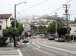
Ulloa Street in West Portal in 2017
Location map San Francisco County.png
Red pog.svg
West Portal
Location within San Francisco
Coordinates: 37°44′27.32″N122°27′56.95″W / 37.7409222°N 122.4658194°W / 37.7409222; -122.4658194
Government
   Supervisor Myrna Melgar
   Assemblymember Phil Ting (D) [1]
   State Senator Scott Wiener (D) [1]
   U. S. Rep. Nancy Pelosi (D) [2]
Area
  Total2.705 sq mi (7.01 km2)
  Land2.705 sq mi (7.01 km2)
Population
  Total2,630
  Density9,230/sq mi (3,560/km2)
ZIP Code
94116, 94127, 94132
Area codes 415/628

West Portal is a small neighborhood in San Francisco, California. West Portal is a primarily residential area of the city. The neighborhood's main corridor, West Portal Avenue, serves as a principal shopping district of southwestern San Francisco.

Contents

Location

West Portal is located at the southern edge of the hills in central San Francisco. The neighborhood is named for the western terminus of the Muni tunnel beneath Twin Peaks that opened in 1918. The ride in the subway from West Portal Station to Castro Station is about seven minutes. By the West Portal Station, the L Taraval goes west along Ulloa Street, and the K Ingleside and the M Ocean View go south along West Portal Avenue. The neighborhood is served by the 48 and 57 Muni bus lines.

Characteristics

Because of its small size and collection of mom and pop stores, restaurants, and saloons, the neighborhood is often described as having a village-like atmosphere. The neighborhood is served by the West Portal Branch of the San Francisco Public Library. Like Glen Park, West Portal is a San Francisco community that almost functions as a small city itself. Though small, the neighborhood has many banks, restaurants of many types, coffee shops, salons, post office, elementary school, drug stores, bakeries, ice cream shops, real estate agents, and spas. West Portal Avenue is dotted with locally owned and operated businesses which include a book store, toy and craft store, produce market, candy shop, and hardware store. West Portal Avenue also has many professional services such as dentists, lawyers, accountants, optometrists, and urgent care facilities.

The frequent fog helps keep the area green in the usually rainless summer months, and on a clear day, West Portal Park, above the Twin Peaks Tunnel, provides a view of the Marin Headlands and the Farallon Islands in the Pacific.

Transit

The neighborhood is served by the Muni train lines L Taraval, M Ocean View, S Shuttle, K Ingleside and T Third Street. [3]

Related Research Articles

<span class="mw-page-title-main">Muni Metro</span> Light rail system

Muni Metro is a light rail system serving San Francisco, California, United States. Operated by the San Francisco Municipal Railway (Muni), a part of the San Francisco Municipal Transportation Agency (SFMTA), Muni Metro served an average of 157,700 passengers per weekday in the fourth quarter of 2019, making it the second-busiest light rail system in the United States.

<span class="mw-page-title-main">M Ocean View</span> San Francisco light rail line

The M Ocean View is a hybrid light rail/streetcar line of the Muni Metro system in San Francisco, California. The line opened on October 6, 1925.

<span class="mw-page-title-main">K Ingleside</span> San Francisco light rail line

The K Ingleside is a hybrid light rail/streetcar line of the Muni Metro system in San Francisco, California. It mainly serves the West Portal and Ingleside neighborhoods. The line opened on February 3, 1918, and was the first line to use the Twin Peaks Tunnel.

<span class="mw-page-title-main">West Portal station</span> Light rail stop in San Francisco

West Portal station is a Muni Metro station in the West Portal neighborhood in San Francisco, California. It is built around the western entrance to the Twin Peaks Tunnel. The station consists of two side platforms, with the entrance at the western end. A non-accessible footbridge connects the platforms inside fare control.

<span class="mw-page-title-main">Twin Peaks Tunnel</span> Tunnel in San Francisco, California for light rail/streetcar system

The Twin Peaks Tunnel is a 2.27-mile-long (3.65 km) light rail/streetcar tunnel in San Francisco, California. The tunnel runs under Twin Peaks and is used by the K Ingleside, M Ocean View and S Shuttle lines of the Muni Metro system.

<span class="mw-page-title-main">Market Street subway</span> BART-Muni Metro main line, San Francisco

The Market Street subway is a two-level subway tunnel that carries Muni Metro and BART trains under Market Street in San Francisco, California. It runs under the length of Market Street between Embarcadero station and Castro station. The upper level is used by Muni Metro lines and the lower level is used by BART lines. BART does not run through the whole subway; it turns south and runs under Mission Street southwest of Civic Center/UN Plaza station. The northeastern end of the BART level is connected to the Transbay Tube. On the Muni Metro level, the southwestern end of the Market Street subway connects to the much-older Twin Peaks Tunnel, and the northeastern end connects to surface tracks along the Embarcadero.

<span class="mw-page-title-main">Balboa Park station</span> Transit station in San Francisco, California, US

Balboa Park station is a Bay Area Rapid Transit (BART) station and Muni Metro complex in the Mission Terrace neighborhood of San Francisco, California, located near the eponymous Balboa Park. It is an intermodal hub served by four BART routes, three Muni Metro lines, and a number of Muni bus routes. The station complex also includes two rail yards, Cameron Beach Yard and Green Light Rail Center, where Muni maintains Muni Metro trains and heritage streetcars. BART uses a below-grade island platform on the west side of the complex; Muni Metro routes use several smaller side platforms located on surface-level rail loops around the yards.

<span class="mw-page-title-main">West Portal and 14th Avenue station</span>

West Portal and 14th Avenue is a light rail stop on the Muni Metro K Ingleside and M Ocean View lines, located in the West Portal neighborhood of San Francisco, California. The station opened along with the Twin Peaks Tunnel and the first stage of the K Ingleside line on February 3, 1918.

<span class="mw-page-title-main">St. Francis Circle station</span>

St. Francis Circle is a light rail stop on the Muni Metro K Ingleside and M Ocean View lines, located in the St. Francis Wood neighborhood of San Francisco, California. It opened around 1907 when the United Railroads (URR) expanded its Ocean Avenue line west to Ocean Beach; Muni service followed with the K in 1918 and the M in 1925.

<span class="mw-page-title-main">Junipero Serra and Ocean station</span>

Junipero Serra and Ocean is a light rail stop on the Muni Metro K Ingleside line, located in the St. Francis Wood neighborhood of San Francisco, California. It originally opened around 1896 on the United Railroads 12 line; K Ingleside service began in 1919.

<span class="mw-page-title-main">Ocean and San Leandro station</span>

Ocean and San Leandro is a light rail stop on the Muni Metro K Ingleside line, located between the Balboa Terrace and Ingleside Terrace neighborhoods of San Francisco, California. It originally opened around 1896 on the United Railroads (12) line; K Ingleside service began in 1919. The stop consists of two side platforms, with the eastbound (outbound) platform located on Ocean Avenue west of the intersection with San Leandro Way, and vice versa.

<span class="mw-page-title-main">Ocean and Aptos station</span>

Ocean and Aptos is a light rail stop on the Muni Metro K Ingleside line, located between the Balboa Terrace and Ingleside Terrace neighborhoods of San Francisco, California. The stop consists of two side platforms, with the eastbound (outbound) platform located on Ocean Avenue west of the intersection with Aptos Avenue, and vice versa. It originally opened around 1896 on the United Railroads 12 line; K Ingleside service began in 1919.

<span class="mw-page-title-main">Ocean and Westgate / Ocean and Cerritos stations</span>

Ocean and Westgate (inbound) and Ocean and Cerritos (outbound) are a pair of one-way light rail stops on the Muni Metro K Ingleside line, located between the Mount Davidson and Ingleside Terrace neighborhoods of San Francisco, California. The stops consist of one side platform each, with the eastbound (outbound) platform located on Ocean Avenue west of the intersection with Westgate Drive and Cerritos Avenue, and vice versa. They originally opened around 1896 on the United Railroads 12 line; K Ingleside service began in 1919.

<span class="mw-page-title-main">Ocean and Fairfield / Ocean and Victoria stations</span>

Ocean and Fairfield (inbound) and Ocean and Victoria (outbound) are a pair of one-way light rail stops on the Muni Metro K Ingleside line, located between the Mount Davidson and Ingleside Terrace neighborhoods of San Francisco, California. The stops consist of one side platform each, with the eastbound (outbound) platform located on Ocean Avenue west of the intersection with Victoria Street, and vice versa. They originally opened in 1895 on the United Railroads 12 line; K Ingleside service began in 1919.

<span class="mw-page-title-main">Ocean and Dorado / Ocean and Jules stations</span>

Ocean and Dorado (inbound) and Ocean and Jules (outbound) are a pair of one-way light rail stops on the Muni Metro K Ingleside line, located between the Mount Davidson and Ingleside neighborhoods of San Francisco, California. The stops consist of one side platform each, with the eastbound (outbound) platform located on Ocean Avenue west of the intersection with Dorado Terrace and Jules Avenue, and vice versa. It originally opened in 1895 on the United Railroads 12 line; K Ingleside service began in 1919.

<span class="mw-page-title-main">Ocean and Miramar station</span>

Ocean and Miramar is a light rail stop on the Muni Metro K Ingleside line, located between the Westwood Park and Ingleside neighborhoods of San Francisco, California. The stop consists of two side platforms, with the eastbound (outbound) platform located on Ocean Avenue west of the intersection with Miramar Avenue, and vice versa. It originally opened in 1895 on the United Railroads 12 line; K Ingleside service began in 1919.

<span class="mw-page-title-main">Ocean and Lee station</span>

Ocean and Lee is a light rail stop on the Muni Metro K Ingleside line, located between the Westwood Park and Ingleside neighborhoods of San Francisco, California. The stop consists of two side platforms, with the eastbound (outbound) platform located on Ocean Avenue west of the intersection with Lee Street, and vice versa.

<span class="mw-page-title-main">Ocean Avenue/CCSF Pedestrian Bridge station</span>

Ocean Avenue/CCSF Pedestrian Bridge station is a light rail stop on the Muni Metro K Ingleside line, located between the Sunnyside and Ingleside neighborhoods of San Francisco, California adjacent to the City College of San Francisco (CCSF) campus. The stop consists of two side platforms in the median of Ocean Avenue, with stairs to a concrete footbridge that connects the campus to Geneva Avenue. It opened in 1979 with the extension of the line to Balboa Park station; it was previously served by the United Railroads 12 line from 1895 to 1945, and the K from 1945 to 1952.

References

  1. 1 2 "Statewide Database". UC Regents. Retrieved December 29, 2014.
  2. "California's 11th Congressional District - Representatives & District Map". Civic Impulse, LLC.
  3. "Muni". 13 June 2017.