Parkside, San Francisco

Last updated
Parkside
Neighborhood
Taraval - Sunset, San Francisco.jpg
Taraval Street and 16th Ave.
Location map San Francisco County.png
Red pog.svg
Parkside
Location within San Francisco
Coordinates: 37°44′38″N122°29′31″W / 37.7440°N 122.4920°W / 37.7440; -122.4920
Country Flag of the United States (23px).png  United States
State Flag of California.svg  California
City-county San Francisco
Government
   Supervisor Joel Engardio
   Assemblymember Phil Ting (D) [1]
   State senator Scott Wiener (D) [1]
   U. S. rep. Nancy Pelosi (D) [2]
Area
  Total2.76 km2 (1.066 sq mi)
Population
  Total16,874
  Density6,110/km2 (15,825/sq mi)
ZIP codes
94116
Area codes 415/628

The Parkside is a neighborhood in the western part of San Francisco, California. [3] It is located in the southern part of the Avenues south of Quintara and north of Sloat Boulevard.

Contents

Also referred to as the "Parkside District," [3] the neighborhood includes the following parks: Parkside Square, Pine Lake, Pine Lake Park (a.k.a. Dog Park), Concert Meadow, Charlie Sava Pool (formerly Carl Larsen Pool), Carl Larsen Park, Stern Grove, McCoppin Park, and McCoppin Square.

Location

The Parkside as a neighborhood started in July 1905 when a syndicate led by William Crocker announced they had quietly bought land from the estate of Adolph Sutro and others to create a new million-dollar development. The "park" of Parkside was not Golden Gate Park, but rather the stand of trees and plants around Laguna Puerca (now called Pine Lake, and often called "Mud Lake" or "Crawdad Lake" by old-timers) [4] west of Sigmund Stern Grove.

The boundaries of the Parkside consist of Quintara Street on the north, Sloat Boulevard on the south, 36th Avenue/Sunset Boulevard on the west, and a diagonal eastern boundary line that abuts on the former Rancho San Miguel property, running from 12th Avenue on the north to 19th Avenue and Sloat on the south. [3] Later with more development to the west from Sloat Boulevard west to the ocean, east to Quintara and south to the San Francisco Zoo the Outer Parkside is also part of the Parkside District of San Francisco.

Parkside Elementary School (located at 25th Avenue and Vicente Street) was closed in 1975 and torn down in 2004. [5] In its place today stands Dianne Feinstein Elementary School at the Parkside Campus. Parkside Library is located at 22nd Avenue and Taraval.

Characteristics

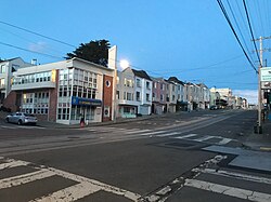
The area is mostly residential, except for the commercial corridor on Taraval Street. Its buildings largely consist of almost identical "cookie-cutter" stucco houses with various decorative elements, which were constructed in the 1920s and 1930s, when assembly-line techniques entered building construction. [3] The L Taraval of the Muni Metro serves the neighborhood and provides a mode of transportation to downtown. Other transit lines include the 29 Sunset, 48 Quintara-24th Street, 66 Quintara, and 18 46th Avenue.

The Parkside branch of the San Francisco Public Library is also located in the area.

The Sigmund Stern Recreation Grove is known as the location of the Stern Grove Festival summer concerts.

The neighborhood is represented by District 4. The current District 4 supervisor is Joel Engardio.

Parkside's distinctive houses Houses on 36th Avenue in the Parkside District, September 2018.JPG
Parkside's distinctive houses

Related Research Articles

<span class="mw-page-title-main">Richmond District, San Francisco</span> Neighborhood in San Francisco, California, United States

The Richmond District is a neighborhood in the northwest corner of San Francisco, California, developed initially in the late 19th century. It is sometimes confused with the city of Richmond, which is 20 miles (32 km) northeast of San Francisco.

<span class="mw-page-title-main">Sunset District, San Francisco</span> Neighborhood in San Francisco, California, United States

The Sunset District is a neighborhood located in the southwest quadrant of San Francisco, California, United States.

<span class="mw-page-title-main">L Taraval</span> Light rail line in San Francisco, California

The L Taraval is a hybrid light rail/streetcar line of the Muni Metro system in San Francisco, California, mainly serving the Parkside District. Since 2021, the line has been suspended and replaced by buses until the end of 2024 for an improvement project along Taraval Street.

<span class="mw-page-title-main">K Ingleside</span> Light rail line in San Francisco, California

The K Ingleside is a hybrid light rail/streetcar line of the Muni Metro system in San Francisco, California. It mainly serves the West Portal and Ingleside neighborhoods. The line opened on February 3, 1918, and was the first line to use the Twin Peaks Tunnel.

<span class="mw-page-title-main">Great Highway</span> Road that forms the western edge of San Francisco along the Pacific Ocean

The Great Highway is a road in San Francisco that forms the city's western edge along the Pacific coast. Built in 1929, it runs for approximately 3.5 miles (5.6 km) next to Ocean Beach. Its southern end is at Skyline Boulevard near Lake Merced; it extends to Point Lobos Avenue and the Cliff House at its northern end. In 2020 a portion of the road was closed to vehicular traffic, opening back to traffic in 2021 during weekdays.

<span class="mw-page-title-main">Stern Grove Festival</span> Performing arts series in San Francisco

The Stern Grove Festival is an admission-free series of performing arts events held during the summer months in San Francisco. Established in 1938, the festival is held at Sigmund Stern Grove, a eucalyptus-wooded natural amphitheater on a 33-acre (130,000-square-meter) site about two miles (three kilometers) south of Golden Gate Park that ranges from 19th Avenue and Sloat Boulevard west to 34th Avenue.

<span class="mw-page-title-main">Sigmund Stern Recreation Grove</span> Concert venue in San Francisco, United States

Sigmund Stern Recreation Grove, locally called Stern Grove, is a 33-acre (130,000 m2) recreational site in the Parkside District. It is administered by the city's Recreation and Parks Department and is the concert setting for the Stern Grove Festival, which has taken place annually since 1938.

<span class="mw-page-title-main">19th Avenue (San Francisco)</span> City street in San Francisco, California

19th Avenue is a north–south city street in San Francisco, California. It consists of two non-contiguous segments that are separated by Golden Gate Park. The southern segment is a six-lane arterial thoroughfare, mostly signed as part of California State Route 1, that goes through the southwestern part of the city. The non-contiguous northern segment is primarily a residential street through the Richmond District.

Merced Manor is a neighborhood in southwestern San Francisco, between Stern Grove and Lake Merced. It is bordered by 19th Avenue to the east, Sloat Boulevard to the north, 26th Avenue to the west and Eucalyptus Drive to the south.

<span class="mw-page-title-main">Junipero Serra and Ocean station</span>

Junipero Serra and Ocean is a light rail stop on the Muni Metro K Ingleside line, located in the St. Francis Wood neighborhood of San Francisco, California. It originally opened around 1896 on the United Railroads 12 line; K Ingleside service began in 1919.

<span class="mw-page-title-main">Taraval and 22nd Avenue / Taraval and 23rd Avenue stations</span>

Taraval and 22nd Avenue / Taraval and 23rd Avenue stations are a pair of light rail stops on the Muni Metro L Taraval line, located in the Parkside neighborhood of San Francisco, California. The eastbound stop is located on Taraval Street and 22nd Avenue, while westbound trains stop on Taraval Street at 23rd Avenue.

<span class="mw-page-title-main">Taraval and 26th Avenue station</span>

Taraval and 26th Avenue is a light rail stop on the Muni Metro L Taraval line, located in the Parkside neighborhood of San Francisco, California. The station opened with the first section of the L Taraval line on April 12, 1919; irregular shuttle service had run on a United Railroads line since around 1910.

<span class="mw-page-title-main">Taraval and 28th Avenue station</span>

Taraval and 28th Avenue was a light rail stop on the Muni Metro L Taraval line, located in the Parkside neighborhood of San Francisco, California. The station opened with the first section of the L Taraval line on April 12, 1919; irregular shuttle service had run on a United Railroads line since around 1910. Service to the station was discontinued on February 25, 2017 as part of the L Taraval Rapid project.

<span class="mw-page-title-main">Taraval and 30th Avenue station</span>

Taraval and 30th Avenue is a light rail stop on the Muni Metro L Taraval line, located in the Parkside neighborhood of San Francisco, California. The station opened with the first section of the L Taraval line on April 12, 1919; irregular shuttle service had run on a United Railroads line since around 1910.

<span class="mw-page-title-main">Taraval and 32nd Avenue station</span>

Taraval and 32nd Avenue is a light rail stop on the Muni Metro L Taraval line, located in the Parkside neighborhood of San Francisco, California. The station opened with the first section of the L Taraval line on April 12, 1919; irregular shuttle service had run on a United Railroads line since around 1910. Nearby 33rd Avenue was the outer terminus of the line until the extension to 48th Avenue on January 14, 1923.

<span class="mw-page-title-main">Taraval and Sunset station</span>

Taraval and Sunset is a light rail stop on the Muni Metro L Taraval line, located in the Parkside neighborhood of San Francisco, California. The station opened with the second section of the L Taraval line on January 14, 1923.

<span class="mw-page-title-main">Taraval and 44th Avenue station</span> Muni Metro station in San Francisco

Taraval and 44th Avenue is a light rail stop on the Muni Metro L Taraval line, located in the Parkside neighborhood of San Francisco, California. The station opened with the second section of the L Taraval line on January 14, 1923.

<span class="mw-page-title-main">46th Avenue and Taraval / Taraval and 46th Avenue stations</span>

46th Avenue and Taraval (eastbound) and Taraval and 46th Avenue (westbound) are a pair of one-way light rail stops on the Muni Metro L Taraval line, located in the Parkside neighborhood of San Francisco, California.

Carl Larsen Park is a 6.6-acre (2.7 ha) neighborhood park in the Parkside District of San Francisco. It lies on the west side of 19th Avenue, at the intersection with Vicente, and just north of Stern Grove. The park is named for Carl Larsen, a chicken rancher, who donated the land for the park to the City in 1926. Larsen Park features a baseball diamond, tennis court, basketball court, playground and indoor pool; the pool, formerly named Larsen Pool, is now named for local swimming instructor Charlie Sava.

References

  1. 1 2 "Statewide Database". UC Regents. Retrieved December 29, 2014.
  2. "California's 11th Congressional District - Representatives & District Map". Civic Impulse, LLC.
  3. 1 2 3 4 LaBounty, Woody; Brandi, Richard (March 2008). "San Francisco's Parkside District: 1905 - 1957" (PDF). Mayor’s Office of Economic and Workforce Development. Retrieved 2013-02-26.
  4. LaBounty, Woody (July 2005). "Parkside District". Western Neighborhoods Project. Retrieved 2013-02-26.
  5. "Parkside School". Western Neighborhoods Project. November 2007. Retrieved 2013-02-26.


37°44′38″N122°29′31″W / 37.7440°N 122.4920°W / 37.7440; -122.4920