Pacific Heights, San Francisco

Last updated

Pacific Heights
Fillmore Street, between Broadway and Vallejo, looking North, San Francisco.jpg
San Francisco Bay as viewed from Fillmore Street, between Broadway and Vallejo.
Location map San Francisco Central.png
Red pog.svg
Pacific Heights
Location within Central San Francisco
Coordinates: 37°47′30″N122°26′08″W / 37.7917°N 122.4356°W / 37.7917; -122.4356
Country Flag of the United States.svg  United States
State Flag of California.svg  California
City-county San Francisco
Government
   Supervisor Catherine Stefani
   State Assembly Phil Ting (D) [1]
   State Senator Scott Wiener (D) [1]
   U. S. Rep. Nancy Pelosi (D) [2]
Area
  Total0.967 sq mi (2.50 km2)
  Land0.967 sq mi (2.50 km2)
Population
  Total21,925
  Density22,677/sq mi (8,756/km2)
Time zone UTC−8 (Pacific)
  Summer (DST) UTC−7 (PDT)
ZIP codes
94109, 94115, 94123
Area codes 415/628
[3]

Pacific Heights (often referred to as Pac Heights [4] ) is a neighborhood in San Francisco, California, United States. It has panoramic views of the Golden Gate Bridge, San Francisco Bay, the Palace of Fine Arts, Alcatraz, and the Presidio.

Contents

The Pacific Heights Residents Association defines the neighborhood as stretching from Union Street to Bush Street in the north–south direction and from Van Ness Avenue to Presidio Avenue in the east–west direction. [5] The San Francisco Mayor's Office of Neighborhood Services defines its north–south extent more narrowly, with Green Street and California & Pine Streets serving as its boundaries. [6] Pacific Heights is situated on a primarily east–west oriented ridge that rises sharply from the Marina District and Cow Hollow neighborhoods to the north to a maximum height of 370 feet (110 m) above sea level. [7] Pacific Heights features two parks, Lafayette and Alta Plaza. Visible to the north are the Golden Gate Bridge, the Marin Headlands, and Alcatraz Island. Visible to the south are Twin Peaks and the Sutro Tower.

A 2013 article named Pacific Heights one of the most expensive neighborhoods in the United States. [8] Since that year, Pacific Heights remains one of the ten most expensive neighborhoods in San Francisco. [9] [10]

Lower Pacific Heights refers to the area located south of California Street down to Post Street. While this area was previously considered part of the Western Addition, [11] the new neighborhood designation became popularized by real estate agents in the early 1990s.[ citation needed ]

History

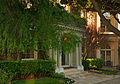
The neighborhood was first developed in the 1870s, [12] with small Victorian-inspired homes built. Starting around the beginning of the 20th century, and especially after the 1906 San Francisco earthquake, many were replaced with period homes. Still residential, the area is characterized by painted Victorian style architecture.

Attractions and characteristics

The oldest building in Pacific Heights, Leale House, located at 2475 Pacific Avenue, was built in 1853, though the majority of the neighborhood was built after the 1906 earthquake. The architecture of the neighborhood is varied; Victorian, Mission Revival, Edwardian, and Château styles are common.

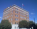
Several countries have consulates in Pacific Heights. They include Italy, [13] Greece, [14] Vietnam, [15] South Korea, [16] China, [17] and Germany. [18]

Most of the neighborhood's boutiques and restaurants can be found along Fillmore Street, south of Pacific Avenue. Other businesses in Pacific Heights are located on California and Divisadero Streets, as well as on Van Ness Avenue.

Pacific Heights is home to several schools, including the San Francisco University High School; Drew School (formerly Drew College Preparatory School); the Hamlin School; Convent of the Sacred Heart High School; Stuart Hall High School, San Francisco Waldorf School, [19] Academy of Thought and Industry, [20] and Town School for Boys, among others. The celebrated Grant Elementary School was open on Pacific Ave from 1922 to 1972. Its students included children of diplomats, the well to do, and the adjacent Presidio military base. [21] Current elementary schools include Hillwood Academic Day School, which opened in 1949. [22]

Events

Pac Heights has played host to many notable events -- both ongoing and one time -- such as:

Government and infrastructure

The San Francisco Police Department Northern Station serves Pacific Heights. [25]

Notable residents

See also

Related Research Articles

<span class="mw-page-title-main">San Francisco</span> Consolidated city-county in California, United States

San Francisco, officially the City and County of San Francisco, is the commercial, financial, and cultural center of Northern California. The city proper is the fourth most populous city in California, with 808,437 residents, and the 17th most populous city in the United States as of 2022. The city covers a land area of 46.9 square miles at the end of the San Francisco Peninsula, making it the second most densely populated large U.S. city after New York City and the fifth-most densely populated U.S. county, behind only four of the five New York City boroughs. Among the 91 U.S. cities proper with over 250,000 residents, San Francisco was ranked first by per capita income and sixth by aggregate income as of 2021. Colloquial nicknames for San Francisco include Frisco, San Fran, The City, and SF.

<span class="mw-page-title-main">Richmond District, San Francisco</span> Neighborhood in San Francisco, California, United States

The Richmond District is a neighborhood in the northwest corner of San Francisco, California, developed initially in the late 19th century. It is sometimes confused with the city of Richmond, which is 20 miles (32 km) northeast of San Francisco.

<span class="mw-page-title-main">Sunset District, San Francisco</span> Neighborhood in San Francisco, California, United States

The Sunset District is a neighborhood located in the southwest quadrant of San Francisco, California, United States.

<span class="mw-page-title-main">Japantown, San Francisco</span> Neighborhood in San Francisco, California, United States

Japantown, also known as J-Town or historically as Japanese Town, is a neighborhood in the Western Addition district of San Francisco, California. Japantown comprises about six city blocks and is considered one of the largest and oldest ethnic enclaves in the United States.

<span class="mw-page-title-main">Hayes Valley, San Francisco</span> Neighborhood in San Francisco, California, United States

Hayes Valley is a neighborhood in the Western Addition district of San Francisco, California. It is located between the historical districts of Alamo Square and the Civic Center. Victorian, Queen Anne, and Edwardian townhouses are mixed with high-end boutiques, restaurants, and public housing complexes. The neighborhood gets its name from Hayes Street, which was named for Thomas Hayes, San Francisco's county clerk from 1853 to 1856 who also started the first Market Street Railway franchise.

<span class="mw-page-title-main">Western Addition, San Francisco</span> Neighborhood of San Francisco in California, United States

<span class="mw-page-title-main">Fillmore District, San Francisco</span> Neighborhood in San Francisco, California, United States

The Fillmore District is a historical neighborhood in San Francisco located to the southwest of Nob Hill, west of Market Street and north of the Mission District. It has been given various nicknames such as “the Moe” or “the Fill”. The Fillmore District began to rise to prominence after the 1906 San Francisco earthquake. As a result of not being affected by the earthquake itself nor the large fires that ensued, it quickly became one of the major commercial and cultural centers of the city.

<span class="mw-page-title-main">Geary Boulevard</span> Thoroughfare in San Francisco, United States

Geary Boulevard is a major east–west 5.8-mile-long (9 km) thoroughfare in San Francisco, California, United States, beginning downtown at Market Street near Market Street's intersection with Kearny Street, and running westbound through downtown, the Civic Center area, the Western Addition, and running for most of its length through the predominantly residential Richmond District. Geary Boulevard terminates near Sutro Heights Park at 48th Avenue, close to the Cliff House above Ocean Beach at the Pacific Ocean. At 42nd Avenue, Geary intersects with Point Lobos Avenue, which takes through traffic to the Cliff House, Ocean Beach and the Great Highway. It is a major commercial artery through the Richmond District; it is lined with stores and restaurants, many of them catering to the various immigrant groups who live in the area. The boulevard borders Japantown between Fillmore and Laguna Streets.

<span class="mw-page-title-main">Visitacion Valley, San Francisco</span> Neighborhood of San Francisco in California, United States

Visitacion Valley, colloquially referred to as Viz Valley, is a neighborhood located in the southeastern quadrant of San Francisco, California.

<span class="mw-page-title-main">Fillmore Street</span>

Fillmore Street is a street in San Francisco, California which starts in the Lower Haight neighborhood and travels northward through the Fillmore District and Pacific Heights and ends in the Marina District. It serves as the main thoroughfare and namesake for the Fillmore District neighborhood. The street is named after American President Millard Fillmore.

<span class="mw-page-title-main">Lower Pacific Heights, San Francisco</span> Place in California, USA

Lower Pacific Heights, also known as Upper Fillmore, is a neighborhood in San Francisco, California, between Pacific Heights, the Fillmore District, Laurel Heights, and Japantown. The neighborhood is centered on the commercial corridor of Fillmore Street between California and Post streets, with California Street to the north, Geary Boulevard to the south, Presidio Avenue to the west, and Van Ness Avenue to the east.

<span class="mw-page-title-main">Marina District, San Francisco</span> Neighborhood of San Francisco in California, United States

The Marina District is a neighborhood located in San Francisco, California. The neighborhood sits on the site of the 1915 Panama–Pacific International Exposition, staged after the 1906 San Francisco earthquake to celebrate the reemergence of the city. Aside from the Palace of Fine Arts, all other buildings were demolished to make the current neighborhood. The Marina currently has the highest non-Hispanic white resident percentage of any recognized neighborhood in San Francisco.

<span class="mw-page-title-main">Laurel Heights, San Francisco</span>

Laurel Heights is a neighborhood of San Francisco, California. It is located to the south of the Presidio of San Francisco and east of the Richmond District. It is bordered by Geary Boulevard and the University of San Francisco campus to the south, Arguello Boulevard to the west, California Street to the north and Presidio Avenue to the east.

Oceanview is a neighborhood in the southern portion of San Francisco, California. It was first established as a community in the 1910s and originally centered on the intersection of Sagamore Street and San Jose Avenue. Today, the neighborhood is bordered by Orizaba Avenue to the west, Lakeview Avenue to the north, and Interstate 280 to the south and east.

<span class="mw-page-title-main">Hillwood Academic Day School</span> School in San Francisco, California, United States

Hillwood Academic Day is a small, independent school for boys and girls in the kindergarten through the eighth grade. The non-denominational school is located at 2521 Scott Street in San Francisco's Pacific Heights neighborhood. It was started in 1949 by Mary Libra and includes a summertime outdoor education program with a lodge in Muir Woods. Eric Grantz, the grandson of Libra and a Hillwood graduate, now runs the school, which has approximately 48 students. Hillwood's mascot is a black labrador retriever, named Max, and the school's colors are forest green and blue. The student publication is The Hillwood Herald, a blog published by the fifth through eighth graders.

<span class="mw-page-title-main">Lincoln Manor</span>

Lincoln Manor is one of the master-planned residence parks in the western neighborhoods of San Francisco, with the others including Sea Cliff, St. Francis Wood, Presidio Terrace, West Clay Park, Forest Hill, Balboa Terrace, Ingleside Terraces, and Jordan Park. Lincoln Manor, established in 1914, is located within the Richmond District, in the Northwest portion of San Francisco. Lincoln Manor is bounded by 36th Avenue to the East, 38th Avenue to the West, Clement Street to the North, Geary Boulevard to the South, and is bisected by Shore View Avenue. The tract features a slight rise in elevation, which provides houses in Lincoln Manor with a view south toward the Pacific Ocean. Its single-family generally large detached homes were developed between approximately 1914-1916 by Lyon & Hoag as a so-called "restricted residence park," built by the S.A. Born Building Company, builders of West Clay Park and Sea Cliff. Lincoln Manor was promoted by its developers as a residence park with ocean views facing south instead of west. The enclave abuts Land's End, Lincoln Park, and the Legion of Honor, and is close to Sea Cliff, the Balboa Street shopping district, and the Katherine Delmar Burke School.

References

  1. 1 2 "Statewide Database". UC Regents. Archived from the original on February 1, 2015. Retrieved December 8, 2014.
  2. "California's 11th Congressional District - Representatives & District Map". Civic Impulse, LLC.
  3. "Pacific Heights neighborhood in San Francisco, California (CA), 94109, 94115, 94123 subdivision profile - real estate, apartments, condos, homes, community, population, jobs, income, streets". www.city-data.com. Retrieved April 9, 2018.
  4. Mueller, Christina (January 12, 2023). "Explore Pac Heights, San Francisco's iconic neighborhood". SFGATE. Retrieved July 23, 2023.
  5. "Mission Statement." Pacific Heights Residents Association. Archived on November 2, 2010
  6. "SF Find Neighborhoods | DataSF | City and County of San Francisco". San Francisco Data. Retrieved June 17, 2020.
  7. Bakalinsky, Adah (October 9, 2013). Stairway Walks in San Francisco. Wilderness Press. p. 66. ISBN   978-0-89997-637-2.
  8. "Americas Most Expensive Neighborhood". 2013.[ dead link ]
  9. "The Most Expensive Neighborhoods in San Francisco". Prevu. June 13, 2023. Retrieved June 26, 2023.
  10. "A Guide to San Francisco's Most Expensive Neighborhoods". California.com. August 13, 2020. Retrieved June 26, 2023.
  11. O'Brien, Tricia (2008). San Francisco's Pacific Heights and Presidio Heights. Arcadia Publishing. p. 7. ISBN   978-0-7385-5980-3.
  12. Richards, Rand (2002). Historic Walks in San Francisco: 18 Trails Through the City's Past. Heritage House Publishers. p. 305. ISBN   978-1-879367-03-6.
  13. "San Francisco Italian Consulate".
  14. "Consulate General in San Francisco - Hellenic Republic - Greece in the USA". www.mfa.gr. Retrieved June 18, 2018.
  15. "English – VietNam Consulate". vietnamconsulate-sf.org. Retrieved June 18, 2018.
  16. "San Francisco South Korean Consulate".
  17. "Consulate General of the People's Republic of China in San Francisco". www.chinaconsulatesf.org. Retrieved June 18, 2018.
  18. Amt, Auswärtiges. "Federal Foreign Office - German Missions in the United States". Seitentitel. Retrieved June 18, 2018.
  19. "San Francisco Waldorf School".
  20. "Academy of Thought and Industry". Archived from the original on November 19, 2017.
  21. "Classically inspired — and connected" . Retrieved April 25, 2017.
  22. The Hillwood Herald
  23. Goldfader-Dufty, Sid (June 30, 2023). "Stuff to do: Fillmore Jazz Fest, SFDanceworks, 'Top Gun' in the Presidio". Mission Local. Retrieved July 23, 2023.
  24. SFGATE, Dan Gentile (October 3, 2020). "Remembering the controversy of the 2005 Fillmore Street ski jump". SFGATE. Retrieved July 23, 2023.
  25. "Northern Station." (Archive) San Francisco Police Department. Retrieved on September 1, 2013.
  26. 1 2 3 John Arlidge (March 17, 2014). "Jonathan Ive Designs Tomorrow". Time. Time Inc. Retrieved March 22, 2014.
  27. "Jay Paul". Forbes. Retrieved September 14, 2015.
  28. Amanda Holpuch, What We Know About the Attack on Nancy Pelosi’s Husband, New York Times (October 29, 2022): "The Pelosis have owned a three-floor red brick townhouse in San Francisco’s exclusive Pacific Heights neighborhood since 1987."

Notes

    37°47′30″N122°26′08″W / 37.7917°N 122.4356°W / 37.7917; -122.4356