
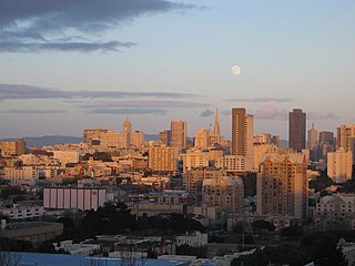
San Francisco, officially the City and County of San Francisco, is a commercial, financial, and cultural center within Northern California. With a population of 808,988 residents as of 2023, San Francisco is the fourth-most populous city in the U.S. state of California behind Los Angeles, San Diego, and San Jose, and the 17th most populous in the US. It covers a land area of 46.9 square miles at the upper end of the San Francisco Peninsula, making it the second-most densely populated major U.S. city behind New York City and the fifth-most densely populated U.S. county, behind four of New York City's boroughs. Among the 91 U.S. cities proper with over 250,000 residents, San Francisco is ranked first by per capita income and sixth by aggregate income as of 2023. San Francisco anchors the 13th most populous metropolitan statistical area in the United States, with almost 4.6 million residents in 2023. The larger San Jose–San Francisco–Oakland combined statistical area, the fifth-largest urban region in the U.S., had a 2023 estimated population of over nine million.

The Richmond District is a neighborhood in the northwest corner of San Francisco, California, developed initially in the late 19th century. It is sometimes confused with the city of Richmond, which is 20 miles (32 km) northeast of San Francisco; accordingly, the neighborhood usually is referred to as "the Richmond."

Bernal Heights is a residential neighborhood in southeastern San Francisco, California. The prominent Bernal Heights hill overlooks the San Francisco skyline and features a microwave transmission tower. The nearby Sutro Tower can be seen from the Bernal Heights neighborhood.
Anza Vista is a neighborhood in the Western Addition district of San Francisco, California. It is named after Juan Bautista de Anza, the first Spanish explorer to reach San Francisco.

San Francisco Unified School District (SFUSD), established in 1851, is the only public school district within the City and County of San Francisco, and the first in the state of California. Under the management of the San Francisco Board of Education, the district serves approximately 49,500 students across 121 schools.

International High School of San Francisco, is a private co-educational high school in Hayes Valley, San Francisco, California, U.S.. Graduates earn either the International Baccalaureate ("IB") or the French Baccalaureate. The IB curriculum is primarily taught in English, while the French Bac is primarily taught in French.

Pacific Heights is a neighborhood in San Francisco, California, United States. It has panoramic views of the Golden Gate Bridge, San Francisco Bay, the Palace of Fine Arts, Alcatraz, and the Presidio.

Pacific Bay Christian School, formerly Alma Heights Christian Academy, is a private Christian middle and high school in Pacifica, California, United States. It was founded by Pillar of Fire International as a segregation academy. In 2018, the school disassociated with Pillar of Fire and reopened as Pacific Bay Christian School.

The Marina Green in San Francisco, California, is a 74-acre (300,000 m2) expanse of grass between Fort Mason and the Presidio. It is adjacent to San Francisco Bay, and this location provides good views of the Golden Gate Bridge, Angel Island, Alcatraz Island, and parts of Marin County. Houses built mostly in the 1920s and 1930s line Marina Boulevard, the southern boundary of the Marina Green. Many of these houses have large bay windows, and Herb Caen, the late San Francisco newspaper columnist, often made references to the immaculate furnishings behind these windows. In the past, a railroad track along the southern edge of the Marina Green allowed the San Francisco Belt Railroad to serve the Presidio. Adjacent to the Marina Green is a marina, home to the St. Francis Yacht Club and the Golden Gate Yacht Club. The San Francisco Bay Trail runs through the green.

Mountain View High School (MVHS) is located at 3535 Truman Avenue, Mountain View, California, 94040. It is one of two Mountain View-Los Altos Union High School District public high schools - the other being Los Altos High School. The three main feeder schools are Graham Middle School, Crittenden Middle School, and Blach Intermediate School.

Marin Country Day School is an independent coeducational day school serving grades K-8 located in Corte Madera, California. The student body is made up of approximately 600 students.
Katherine Delmar Burke School, commonly known as Burke's, is an independent girls' school for kindergarten through eighth grade, located in the Sea Cliff neighborhood of San Francisco, California, United States, near Lincoln Park. Until 1975 it also included a high school. It was founded in 1908 by Katherine Delmar Burke and was named Miss Burke's School.

Yerba Buena was the name of an anchorage spot and later a town that grew into the city of San Francisco, California. The settlement, built in an area known earlier as El Paraje de Yerba Buena and named for an herb that grew abundantly there, was founded in 1834 and was located near the northeastern end of the San Francisco Peninsula, on the shores of Yerba Buena Cove. Yerba Buena was the first civilian pueblo in San Francisco, which had previously only had indigenous, missionary, and military settlements, and was originally intended as a trading post for ships visiting San Francisco Bay. The settlement was arranged in the Spanish style around a plaza that remains as the present day Portsmouth Square. The area that was the Yerba Buena settlement is now in the Financial District and Chinatown neighborhoods of San Francisco.
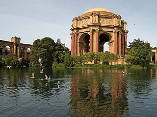
The Marina District is a neighborhood located in San Francisco, California. The neighborhood sits on the site of the 1915 Panama–Pacific International Exposition, staged after the 1906 San Francisco earthquake to celebrate the reemergence of the city. Aside from the Palace of Fine Arts, all other buildings were demolished to make the current neighborhood.

Laurel Heights is a neighborhood of San Francisco, California. It is located to the south of the Presidio of San Francisco and east of the Richmond District. It is bordered by Geary Boulevard and the University of San Francisco campus to the south, Arguello Boulevard to the west, California Street to the north and Presidio Avenue to the east.

Sea Cliff is a neighborhood in northwestern San Francisco, California. It is known for its large houses and ocean views. Sea Cliff is one of nine master–planned residence parks in San Francisco; its master plan was developed by landscape architect Mark Daniels. Sea Cliff has become one of San Francisco's most elite residential areas.
San Francisco Waldorf School (SFWHS) is an independent preK–12 school in San Francisco, California. The school is based on the principles of Waldorf education. The kindergarten and grade school are located at 2938 Washington Street and the high school is located at 470 West Portal Avenue. About 50% of students at the high school also attended the grade school, the rest coming from public, parochial, and other independent schools. It is accredited by the Western Association of Schools and Colleges (WASC) and the Association of Waldorf Schools of North America (AWSNA).

Nob Hill is a neighborhood of San Francisco, California, United States that is known for its numerous luxury hotels and historic mansions. Nob Hill has historically served as a center of San Francisco's upper class. Nob Hill is among the highest-income neighborhoods in the United States, as well as one of the most desirable and expensive real estate markets in the country. Prior to Covid-19, it was the most expensive real estate market per metre squared, narrowly beating Monte Carlo, although it has since fallen heavily. It was the only place in the United States so far where market price per square metre exceeded the average yearly salary in the country.

Archbishop's Mansion is a historic house built in 1904 and located at 1000 Fulton Street in the Alamo Square neighborhood in San Francisco, California. The mansion was built for Patrick William Riordan, the second Roman Catholic Archbishop of San Francisco.

