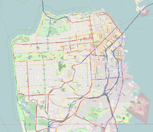
San Francisco, officially the City and County of San Francisco, is a commercial, financial, and cultural center of Northern California. The city proper is the fourth most populous in California, with 808,437 residents as of 2022, and covers a land area of 46.9 square miles, at the end of the San Francisco Peninsula, making it the second most densely populated large U.S. city after New York City and the fifth-most densely populated U.S. county, behind only four of the five New York City boroughs. Among the 91 U.S. cities proper with over 250,000 residents, San Francisco was ranked first by per capita income and sixth by aggregate income as of 2021. Colloquial nicknames for San Francisco include SF, San Fran, The City, Frisco, and Baghdad by the Bay.

San Mateo County, officially the County of San Mateo, is a county located in the U.S. state of California. As of the 2020 census, the population was 764,442. Redwood City is the county seat, and the third most populated city following Daly City and San Mateo. San Mateo County is included in the San Francisco-Oakland-Berkeley, CA MSA, Silicon Valley, and is part of the San Francisco Bay Area, the nine counties bordering San Francisco Bay. It covers most of the San Francisco Peninsula. San Francisco International Airport is located in the northeastern area of the county and is approximately 7 miles south of the city and county limits of San Francisco, even though the airport itself is assigned a San Francisco postal address. The county's built-up areas are mostly suburban, and are home to several corporate campuses.

Santa Rosa is a city and the county seat of Sonoma County, in the North Bay region of the Bay Area in California. Its population as of the 2020 census was 178,127. It is the largest city in California's Wine Country and Redwood Coast. It is the fifth most populous city in the Bay Area after San Jose, San Francisco, Oakland, and Fremont; and the 25th most populous city in California.
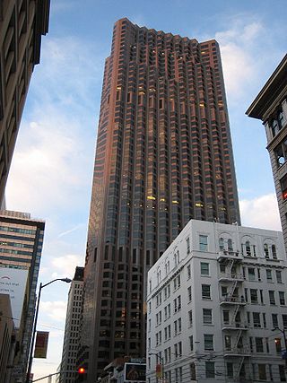
555 California Street, formerly Bank of America Center, is a 52-story 779 ft (237 m) skyscraper in San Francisco, California. It is the fourth tallest building in the city as of February 2021, and in 2013 was the largest by floor area. Completed in 1969, the tower was the tallest building west of the Mississippi River until the completion of the Transamerica Pyramid in 1972, and the world headquarters of Bank of America until the 1998 merger with NationsBank, when the company moved its headquarters to the Bank of America Corporate Center in Charlotte, North Carolina. It is currently owned by Vornado Realty Trust and The Trump Organization.

Mission Dolores Park, often abbreviated to Dolores Park, is a city park in San Francisco, California. It is located two blocks south of Mission Dolores at the western edge of the Mission District.

Union Square is a 2.6-acre (1.1-hectare) public plaza bordered by Geary, Powell, Post, and Stockton Streets in downtown San Francisco, California. "Union Square" also refers to the central shopping, hotel, and theater district that surrounds the plaza for several blocks. The area got its name because it was once used for Thomas Starr King rallies and support for the Union Army during the American Civil War, earning its designation as a California Historical Landmark.

The Embarcadero is the eastern waterfront and roadway of the Port of San Francisco, San Francisco, California, along San Francisco Bay. It was constructed on reclaimed land along a three mile long engineered seawall, from which piers extend into the bay. It derives its name from the Spanish verb embarcar, meaning "to embark"; embarcadero itself means "the place to embark." The Central Embarcadero Piers Historic District was added to the National Register of Historic Places on November 20, 2002.
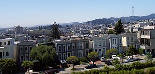
The Western Addition is a district in San Francisco, California, United States.

The Chinatown neighborhood in Oakland, California(Chinese: 屋崙華埠), is traditionally Chinese which reflects Oakland's diverse Chinese American, and more broadly Asian American community. It is frequently referred to as "Oakland Chinatown" in order to distinguish it from nearby San Francisco's Chinatown. It lies at an elevation of 39 feet.

Pacific Heights is a neighborhood in San Francisco, California. It has panoramic views of the Golden Gate Bridge, San Francisco Bay, the Palace of Fine Arts, Alcatraz, and the Presidio.
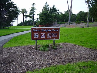
Sutro Heights Park is an historic public park in the Outer Richmond District of western San Francisco, California. It is within the Golden Gate National Recreation Area and the Sutro Historic District.

Telegraph Hill is a hill and surrounding neighborhood in San Francisco, California. It is one of San Francisco's 44 hills, and one of its original "Seven Hills".
The 49-Mile Scenic Drive is a designated scenic road tour highlighting much of San Francisco, California. It was created in 1938 by the San Francisco Down Town Association to showcase the city's major attractions and natural beauty during the 1939 Golden Gate International Exposition.

Corona Heights Park is a park in the Castro and Corona Heights neighborhoods of San Francisco, California, United States. It is situated immediately to the south of Buena Vista Park. Corona Heights is bounded in part by Flint Street on the east, Roosevelt Way to the north, and 16th Street to the south. The base of the hill is at approximately 300 feet (91 m), while the peak extends to 520 feet (160 m) above sea level.

California Street is a major thoroughfare in San Francisco, California. It is one of the longest streets in San Francisco, and includes a number of important landmarks. It runs in an approximately straight 5.2 mi (8.4 km) east-west line from the Financial District to Lincoln Park in the far Northwest corner of the City.
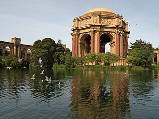
The Marina District is a neighborhood located in San Francisco, California. The neighborhood sits on the site of the 1915 Panama–Pacific International Exposition, staged after the 1906 San Francisco earthquake to celebrate the reemergence of the city. Aside from the Palace of Fine Arts, all other buildings were demolished to make the current neighborhood. The Marina currently has the highest non-Hispanic white resident percentage of any recognized neighborhood in San Francisco.
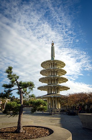
The San Francisco Peace Pagoda is a five-tiered concrete stupa between Post and Geary Streets at Buchanan in San Francisco's Nihonmachi (Japantown). The Pagoda, located in the southwestern corner of Peace Plaza between the Japan Center Mall and Nihonmachi Mall, was constructed in the 1960s and presented to San Francisco by its sister city Osaka, Japan on March 28, 1968. It was designed by Japanese architect Yoshiro Taniguchi.