Panhandle (San Francisco)

Last updated
Panhandle
Panhandle.JPG
The Panhandle from Clayton Street
Panhandle (San Francisco)
TypeMunicipal (San Francisco)
Location San Francisco
Created1870
StatusOpen all year
ParkingStreet parking

The Panhandle is a public park in San Francisco, California, so named because it forms a panhandle with Golden Gate Park. It is long and narrow, being three-quarters of a mile (eight blocks) long and just one block wide. Fell and Oak Streets border it to the north and south, Baker Street to the east, and to the west Stanyan Street which separates the smaller Panhandle from the much larger Golden Gate Park. The Panhandle is bisected by Masonic Avenue, which runs north to south and cuts through the middle of the park. In its westernmost block, Oak and Fell Streets angle across the Panhandle, converge with one another, and continue west of Stanyan as John F. Kennedy Drive and Kezar Drive.

Contents

Two paved walking paths, one allowing bicycles, run the entire length of the Panhandle from east to west, and several shorter ones criss-cross it north to south. In its western section, between Stanyan and Masonic, the Panhandle contains basketball courts, [1] a public restroom, a playground, and an outdoor gym. The William McKinley Memorial is at the eastern end of the Panhandle, just across Baker Street from the DMV; it consists of a statue and seating area, and was dedicated in 1904 by President Theodore Roosevelt, who succeeded McKinley after his assassination in 1901. [2]

The Panhandle forms the southern boundary of the Western Addition neighborhood and the northern boundary of the Haight-Ashbury district.

History

An 1853 map of San Francisco labels the area that the Panhandle and Golden Gate Park presently occupy the "Great Sand Bank". In 1870, the Panhandle's footprint occupied large, shifting sand-dunes with little vegetation in between it and the Pacific Ocean known as the "Outside Lands". The large hills of sand, semi-arid conditions, and powerful winds generated by the Golden Gate effect conspired to make agriculture and gardening nearly impossible—except for in a few small valleys protected from the constant winds.

William Hammond Hall's long-term plan to create a vast recreational park in San Francisco was first implemented in The Panhandle in 1870, which became part of Hall's experimental laboratory for finding suitable vegetation for reclaiming the dunes. After much trial and error, Hall found that by first planting barley, followed months later by sea bent grass mixed with yellow lupin, the sand dunes could be stabilized enough to dump manure and top-soil without risk of wind erosion. On top of this layer, Monterey Pines, Monterey Cypresses and Eucalyptus—all known for quick growth and shallow root structures—could take root.

After Hall tamed the dunes, the Panhandle was ready to accept planting of hundreds of tree varietals, representing regions from all over the world, including such species as Bailey's Acacia, Japanese Yew, Black Walnut, Blackwood Acacia, Queensland Kauri, and Italian Alder. The land in and around the Panhandle has been so completely transformed by over 100 years of irrigation and development that the sandy, unstable ground beneath is no longer apparent.

In 1899, a proposal was considered for an expansion of the Panhandle due eastward, across Van Ness Avenue and all the way to Market Street downtown. [3] Another idea in 1928 proposed extending the Panhandle diagonally across the Lower Haight and Duboce Triangle neighborhoods and reaching Market Street further west. Neither of these were ever carried out.

In the 1950s, a freeway was proposed that would have run through the Panhandle, taking the place of a road running through the park known as The Avenue Drive, [4] [5] [6] but due to a citizen freeway revolt it was canceled; the San Francisco Board of Supervisors voted in 1959 and again in 1966 against building the Panhandle freeway. [7] Instead, the road through the Panhandle was removed entirely and the streets on either side of it were turned into wide, one-way streets, with traffic lights timed to allow cars to move continuously at 20 (formerly 25) miles per hour. Similar one-way pairs of rapid through-streets exist throughout San Francisco.

The popular bike and walking path along the north side of the Panhandle, along with the Fell and Oak Street Bikeways, The Wiggle, and Market Street, form an important link between the largely residential Richmond and Sunset Districts, which are west of Twin Peaks, and other areas to the east, including the Civic Center, Financial District, and Mission District. This route follows the terrain in such a way as to allow someone to traverse San Francisco without having to climb its steepest hills. The Bikeways, which feature physical barriers that separate the bike traffic from the fast-moving car traffic, were built by removing three blocks of parking from the south side of both streets (between Baker and Scott), an almost impossible political feat in car-clogged San Francisco. [8] [9] In addition to the bike and walking path, west-bound riders can also use a bicycles-only curb lane, which is separated from moving traffic by a parking lane, on Fell Street along the north side of the Panhandle.

Related Research Articles

<span class="mw-page-title-main">Sunset District, San Francisco</span> Neighborhood in San Francisco, California, United States

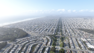
The Sunset District is a neighborhood located in the southwest quadrant of San Francisco, California, United States.

<span class="mw-page-title-main">Haight-Ashbury</span> Neighborhood in San Francisco, California, United States

Haight-Ashbury is a district of San Francisco, California, named for the intersection of Haight and Ashbury streets. It is also called The Haight and The Upper Haight. The neighborhood is known as one of the main centers of the counterculture of the 1960s.

<span class="mw-page-title-main">Golden Gate Park</span> Public park in San Francisco, California, United States

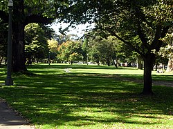
Golden Gate Park is an urban park between the Richmond and Sunset districts of San Francisco, United States. It is the largest park in the city, containing 1,017 acres (412 ha), and the third-most visited urban park in the United States, with an estimated 24 million visitors annually.

<span class="mw-page-title-main">Central Freeway</span> Elevated freeway in San Francisco, California, United States

The Central Freeway is a roughly one-mile (1.5 km) elevated freeway in San Francisco, California, United States, connecting the Bayshore/James Lick Freeway with the Hayes Valley neighborhood. Most of the freeway is part of US 101, which exits at Mission Street on the way to the Golden Gate Bridge. The freeway once extended north to Turk Street, and initially formed part of a loop around downtown, but was damaged along with the Embarcadero in the 1989 Loma Prieta earthquake; both highways have since been replaced with the surface-level Octavia Boulevard and Embarcadero, respectively.

<span class="mw-page-title-main">Hayes Valley, San Francisco</span> Neighborhood in San Francisco, California, United States

Hayes Valley is a neighborhood in the Western Addition district of San Francisco, California. It is located between the historical districts of Alamo Square and the Civic Center. Victorian, Queen Anne, and Edwardian townhouses are mixed with high-end boutiques, restaurants, and public housing complexes. The neighborhood gets its name from Hayes Street, which was named for Thomas Hayes, San Francisco's county clerk from 1853 to 1856 who also started the first Market Street Railway franchise.

<span class="mw-page-title-main">Western Addition, San Francisco</span> Neighborhood of San Francisco in California, United States

<span class="mw-page-title-main">Cole Valley, San Francisco</span> Neighborhood of San Francisco

Cole Valley is a small neighborhood in San Francisco, California. It borders Golden Gate Park to the north, Haight-Ashbury to the northeast, The Castro to the east. and Twin Peaks to the south. Near Kezar Stadium, Cole Valley is the smallest neighborhood in the city.

<span class="mw-page-title-main">Haight Street</span> Street in San Francisco, USA

Haight Street is the principal street in San Francisco's Haight-Ashbury district, also known as the Upper Haight due to its elevation. The street stretches from Market Street, through the Lower Haight neighborhood, to Stanyan Street in the Upper Haight, at Golden Gate Park. In most blocks it is residential, but in the Upper and Lower Haight it is also a neighborhood shopping street, with residences above the ground floor shops. It is named after California pioneer and exchange banker Henry Haight (1820–1869).

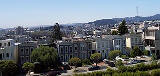
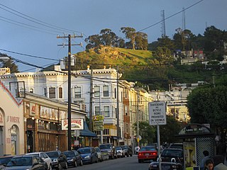
The Lower Haight is a neighborhood, sometimes referred to as Haight–Fillmore, in San Francisco, California.

<span class="mw-page-title-main">Octavia Boulevard</span> Major road in San Francisco

Octavia Boulevard is a major street in San Francisco, California, that replaced the Hayes Valley portion of the damaged two-level Central Freeway. Once a portion of Octavia Street alongside shadowy, fenced-off land beneath the elevated U.S. Route 101 roadway, Octavia Boulevard was redeveloped and redesigned upon the suggestion of Mark Jolles of San Francisco.

The 49-Mile Scenic Drive is a designated scenic road tour highlighting much of San Francisco, California. It was created in 1938 by the San Francisco Down Town Association to showcase the city's major attractions and natural beauty during the 1939 Golden Gate International Exposition.

<span class="mw-page-title-main">The Wiggle</span> Bycicle route in San Francisco

<span class="mw-page-title-main">Recreation Park (San Francisco)</span>

Recreation Park was the name applied to several former baseball parks in San Francisco, California in the late 19th century and early 20th century.

<span class="mw-page-title-main">Stanyan Street</span>

Stanyan Street is a north–south street in San Francisco, California marking the eastern side of the Golden Gate Park and the western side of the Panhandle. It is named after Charles H. Stanyan, a city supervisor from 1866 to 1869 who was on the committee which sited the park.

<span class="mw-page-title-main">Sue Bierman</span> American politician active in San Francisco

Sue Bierman was a civic leader in San Francisco, serving on the San Francisco Planning Commission, the Board of Supervisors, and the Port Commission.

<span class="mw-page-title-main">William McKinley Memorial</span> William McKinley Memorial, San Francisco

The William McKinley Memorial, is a statue honoring the assassinated United States President William McKinley which stands at the foot of the Panhandle Park, San Francisco, California, facing the DMV across Baker Street. Created by Robert Ingersoll Aitken (1878–1949) in 1904, the Monument was dedicated in 1903 by President Theodore Roosevelt, who succeeded McKinley after his assassination in 1901. The monument was unveiled on November 24, 1904 at the entrance to the Golden Gate Park panhandle. Over 5,000 people came to the unveiling. Speeches were made by former Mayor James D. Phelan, Mayor Eugene Schmitz, John McNaught, and others.

<span class="mw-page-title-main">33 Ashbury/18th Street</span>

33 Ashbury/18th Street is a trolleybus line operated by the San Francisco Municipal Railway. The route is descendant from the first trolleybus service to open in San Francisco.

<span class="mw-page-title-main">6 Haight/Parnassus</span> Trolleybus line in San Francisco, CA, US

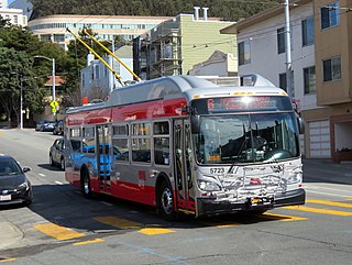
6 Haight/Parnassus is a trolleybus line operated by the San Francisco Municipal Railway (Muni). It connects the Financial District to the Inner Sunset and Forest Hill via Haight-Ashbury.

<span class="mw-page-title-main">7 Haight/Noriega</span>

7 Haight/Noriega is a bus route operated by the San Francisco Municipal Railway (Muni). It connects the central business district to the Outer Sunset via Haight-Ashbury.

References

  1. "Court profile of Panhandle basketball court". courtsoftheworld.com.
  2. "McKinley Memorial, (sculpture)". Smithsonian Institution . Retrieved January 4, 2022.
  3. "The San Francisco Call". April 26, 1899. p. 9. Retrieved 2009-09-05.
  4. "1938 aerial view of San Francisco's Golden Gate Park Panhandle". 1938. Retrieved Mar 30, 2013.
  5. "Instead of Bikes, the Panhandle Used to Allow Cars - Then & Now - Curbed SF". Dec 7, 2012. Retrieved Mar 31, 2013.
  6. "The "Chevalier" Commercial, Pictorial and Tourist Map of San Francisco From Latest U.S. Gov. and Official Surveys. Designed-Engraved And Copyrighted By Aug. Chevalier, Lithographer Publisher, San Francisco ... copyrighted 1911 ... - David Rumsey Historica". 1911. Retrieved Mar 31, 2013.
  7. Adams, Gerald (2003-03-28). "Farewell to freeway: Decades of revolt force Fell Street off-ramp to fall". San Francisco Chronicle.
  8. Lekach, Sasha (16 October 2012). "SFMTA Approves Plan To Slow Traffic Along Fell And Oak Streets". SF Appeal. Retrieved 13 December 2012.
  9. Bialick, Aaron (17 October 2012). "SFMTA Board Approves Fell and Oak Bikeways, Work to Begin This Month". Streetsblog San Francisco. Retrieved 13 December 2012.

37°46′19″N122°27′00″W / 37.772°N 122.450°W / 37.772; -122.450 (The Panhandle)