
California is a state in the Western Region of the United States that lies on the Pacific Coast. It borders Oregon to the north, Nevada and Arizona to the east, and shares an international border with the Mexican state of Baja California to the south. With over 39 million residents across an area of 163,696 square miles (423,970 km2), it is the most populous U.S. state, the third-largest by area, and most populated subnational entity in North America.

San Francisco Bay is a large tidal estuary in the U.S. state of California, and gives its name to the San Francisco Bay Area. It is dominated by the cities of San Francisco, San Jose, and Oakland.

San Francisco, officially the City and County of San Francisco, is a commercial, financial, and cultural center within Northern California. With a population of 808,988 residents as of 2023, San Francisco is the fourth-most populous city in the U.S. state of California behind Los Angeles, San Diego, and San Jose, and the 17th most populous in the US. It covers a land area of 46.9 square miles at the upper end of the San Francisco Peninsula, making it the second-most densely populated major U.S. city behind New York City and the fifth-most densely populated U.S. county, behind four of New York City's boroughs. Among the 91 U.S. cities proper with over 250,000 residents, San Francisco is ranked first by per capita income and sixth by aggregate income as of 2023. San Francisco anchors the 13th most populous metropolitan statistical area in the United States, with almost 4.6 million residents in 2023. The larger San Jose–San Francisco–Oakland combined statistical area, the fifth-largest urban region in the U.S., had a 2023 estimated population of over nine million.

The Sierra Nevada is a mountain range in the Western United States, between the Central Valley of California and the Great Basin. The vast majority of the range lies in the state of California, although the Carson Range spur lies primarily in Nevada. The Sierra Nevada is part of the American Cordillera, an almost continuous chain of mountain ranges that forms the western "backbone" of the Americas.

California is a U.S. state on the western coast of North America. Covering an area of 163,696 sq mi (423,970 km2), California is among the most geographically diverse states. The Sierra Nevada, the fertile farmlands of the Central Valley, and the arid Mojave Desert of the south are some of the geographic features of this U.S. state. It is home to some of the world's most exceptional trees: the tallest, most massive, and oldest. It is also home to both the highest and lowest points in the 48 contiguous states.

Alcatraz Island is a small island 1.25 miles (2.01 km) offshore from San Francisco, California, United States. The island was developed in the mid-19th century with facilities for a lighthouse, a military fortification, and a military prison. In 1934, the island was converted into a federal prison, Alcatraz Federal Penitentiary. The strong currents around the island and cold water temperatures made escape nearly impossible, and the prison became one of the most notorious in American history. The prison closed in 1963, and the island is now a major tourist attraction.

Northern California is a geographic and cultural region that comprises the northern portion of the U.S. state of California, spanning the northernmost 48 of the state's 58 counties. Northern California in its largest definition is determined by dividing the state into two regions, the other being Southern California. The main northern population centers include the San Francisco Bay Area, the Greater Sacramento area, the Redding, California, area south of the Cascade Range, and the Metropolitan Fresno area. Northern California also contains redwood forests, along with most of the Sierra Nevada, including Yosemite Valley and part of Lake Tahoe, Mount Shasta, and most of the Central Valley, one of the world's most productive agricultural regions. Northern California is also home to Silicon Valley, the global headquarters for some of the most powerful tech and Internet-related companies in the world, including Meta, Apple, Google, and Nvidia.

Golden Gate Park is an urban park between the Richmond and Sunset districts of San Francisco, California, United States. It is the second-largest park in the city, containing 1,017 acres (412 ha), and the third-most visited urban park in the United States, with an estimated 24 million visitors annually.

The California Zephyr was a passenger train that ran between Chicago, Illinois, and Oakland, California, via Omaha, Denver, Salt Lake City, Winnemucca, Oroville and Pleasanton in the United States. It was operated by the Chicago, Burlington & Quincy (CB&Q), Denver & Rio Grande Western (D&RGW) and Western Pacific (WP) railroads, all of which dubbed it "the most talked about train in America" on March 19, 1949, with the first departure the following day. The train was scheduled to pass through the most spectacular scenery on its route in the daylight. The original train ceased operation in 1970, though the D&RGW continued to operate its own passenger service, the Rio Grande Zephyr, between Salt Lake City and Denver, using the original equipment until 1983. In 1983 a second iteration of the California Zephyr, an Amtrak service, was formed. The current version of the California Zephyr operates partially over the route of the original Zephyr and partially over the route of its former rival, the City of San Francisco.

Crissy Field is a public recreation area on the northern shore of the San Francisco Peninsula in California, United States, located just east of the Golden Gate Bridge. It includes restored tidal marsh and beaches.

Fort Mason, in San Francisco, California is a former United States Army post located in the northern Marina District, alongside San Francisco Bay. Fort Mason served as an Army post for more than 100 years, initially as a coastal defense site and subsequently as a military port facility. During World War II, it was the principal port for the Pacific campaign.

Telegraph Hill is a hill and surrounding neighborhood in San Francisco, California. It is one of San Francisco's 44 hills, and one of its original "Seven Hills".
The 49-Mile Scenic Drive is a designated scenic road tour highlighting much of San Francisco, California. It was created in 1938 by the San Francisco Down Town Association to showcase the city's major attractions and natural beauty during the 1939 Golden Gate International Exposition.
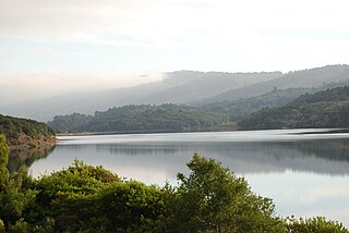
Crystal Springs Reservoir is a pair of artificial lakes located in the northern Santa Cruz Mountains of San Mateo County, California operated by the San Francisco Public Utilities Commission for water supply to the San Francisco peninsula. The reservoirs are located in the rift valley created by the San Andreas Fault just to the west of the cities of San Mateo and Hillsborough, and I-280. The lakes are part of the San Mateo Creek watershed. Crystal Springs Regional Trail runs along the reservoir.

Fort Funston is a former harbor defense installation located in the southwestern corner of San Francisco. Formerly known as the Lake Merced Military Reservation, the fort is now a protected area within the Golden Gate National Recreation Area (GGNRA) and is used widely as an off-leash dog park. It was named in honor of Frederick N. Funston (1865–1917), a Major General in the United States Army with strong connections to San Francisco, and included several artillery batteries. The fort is located on Skyline Boulevard at John Muir Drive, west of Lake Merced.

Golden Gate Airlines was a United States regional airline founded in 1980 in Monterey, California after the merger of Gem State Airlines and Air Pacific (USA) in 1979. It merged again in 1981, this time with Swift Aire Lines, but discontinued service shortly thereafter and then went out of business.

The San Francisco Bay Area, commonly known as the Bay Area, is a region of California surrounding and including San Francisco Bay, and anchored by the cities of San Francisco, Oakland, and San Jose. The Association of Bay Area Governments defines the Bay Area as including the nine counties that border the estuaries of San Francisco Bay, San Pablo Bay, and Suisun Bay: Alameda, Contra Costa, Marin, Napa, San Mateo, Santa Clara, Solano, Sonoma, and San Francisco. Other definitions may be either smaller or larger, and may include neighboring counties which are not officially part of the San Francisco Bay Area, such as the Central Coast counties of Santa Cruz, San Benito, and Monterey, or the Central Valley counties of San Joaquin, Merced, and Stanislaus. The Bay Area is known for its natural beauty, prominent universities, technology companies, and affluence. The Bay Area contains many cities, towns, airports, and associated regional, state, and national parks, connected by a complex multimodal transportation network.
San Francisco Nature Education is a non-profit environmental education organization in San Francisco, California that provides interactive environmental education programs for the development of leadership and stewardship in youth and adults. It was founded by Nancy DeStefanis, who serves as its executive director.

The Spreckels Lake Model Yacht Facility, commonly referred to as "Spreckels Lake", is an artificial reservoir behind an earthen dam and adjoining clubhouse situated on the northern side of San Francisco's Golden Gate Park. Completed in mid-March 1904, the reservoir was built for the use of model boaters of all ages, interests, and skill levels, designed specifically for racing model sail and power boats and to propagate the skills and crafts necessary to build and sail competitive model boats of all types. The Spreckels Lake Model Yacht Facility is considered one of the finest examples and one of the most beautiful of the naturalistically styled, man-made model boating facilities in the world and is always open to anyone wishing to sail its waters with few restrictions. The facility is also the permanent home to the San Francisco Model Yacht Club (SFMYC), the organization at whose request Spreckels Lake and the adjoining clubhouses were built and whose history is and always will be irrevocably intertwined with the history of the facility.

The Golden Gate Fortune Cookie Factory is a fortune cookie company with its main entrance off Ross Alley, between Jackson Street and Washington Street in the Chinatown neighborhood of San Francisco, California in the United States.

