Van Ness station

Last updated
Muni worm logo.svg Van Ness
Van Ness station with new escalator, March 2019.JPG
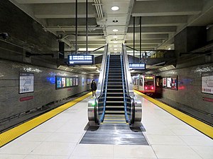
Van Ness station with an inbound train in March 2019
General information
Location1500 Market Street
San Francisco, California
Coordinates 37°46′30″N122°25′08″W / 37.775°N 122.419°W / 37.775; -122.419
Owned by San Francisco Municipal Transportation Agency
Line(s) Market Street subway
Platforms1 high level island platform (Muni Metro)
2 low level side platforms (Muni surface)
Tracks2 (Muni Metro)
2 (Muni surface)
ConnectionsAiga bus trans.svg Muni: 6, 7, 9, 9R, Van Ness BRT (47, 49, 79X)
Construction
Structure typeUnderground
AccessibleYes
ArchitectReid & Tarics Associates [1]
History
OpenedFebruary 18, 1980 [2]
Services
Preceding station BSicon LOGO SFmuni.svg Muni Following station
Church and Duboce
towards Balboa Park
J Church Civic Center
towards Embarcadero
Church
towards Balboa Park
K Ingleside
Church
towards SF Zoo
L Taraval
Suspended
Church M Ocean View
Church and Duboce
towards Ocean Beach
N Judah Civic Center
towards 4th and King
Church
towards West Portal
S Shuttle Civic Center
towards Embarcadero
At surface stops
Market and Gough F Market & Wharves Market and 9th Street / Market and Larkin
through to Mission Street or 11th Street Van Ness BRT McAllister
towards Union

Van Ness station is an underground Muni Metro station on the Market Street subway at the intersection of Market Street and Van Ness Avenue (U.S. Route 101) in San Francisco, California. The station consists of a concourse mezzanine on the first floor down, and a single island platform on the second level down.

Contents

History

A southbound bus at the 2022-opened Van Ness Bus Rapid Transit stop Muni route 49 bus arriving at Market Street stop, April 2022.JPG
A southbound bus at the 2022-opened Van Ness Bus Rapid Transit stop

The station was constructed by BART as part of the Market Street subway. The BART Board approved the name "Van Ness" in December 1965. [3] Service at the station began in February 1980. [2]

The station has suffered flooding during heavy rainstorms, including one in October 2009, and another in December 2014 which damaged an electrical equipment room. [4] [5] In February 2017, the SFMTA signed a $1.9 million contract to repair water-damaged wiring in the room. [6] Surface stops on Van Ness Avenue at Market Street are the southern end of the Van Ness Bus Rapid Transit route, which began service on April 1, 2022. The northeast headhouse was closed on March 11, 2023, for an estimated six months during construction of an adjacent building. [7]

Under the proposed western variant of the planned Better Market Street project, the outbound F stop would be moved across the intersection. [8]

Related Research Articles

<span class="mw-page-title-main">San Francisco Municipal Railway</span> Public transport agency in San Francisco, California, USA

The San Francisco Municipal Railway ( MEW-nee; SF Muni or Muni), is the primary public transit system within San Francisco, California. It operates a system of bus routes, the Muni Metro light rail system, three historic cable car lines, and two historic streetcar lines. Previously an independent agency, the San Francisco Municipal Railway merged with two other agencies in 1999 to become the San Francisco Municipal Transportation Agency (SFMTA). In 2018, Muni served 46.7 square miles (121 km2) with an operating budget of about $1.2 billion. Muni is the seventh-highest-ridership transit system in the United States, with 142,168,200 rides in 2023, and the second-highest in California after the Los Angeles County Metropolitan Transportation Authority.

<span class="mw-page-title-main">Muni Metro</span> Light rail system in San Francisco

Muni Metro is a semi-metro system serving San Francisco, California, United States. Operated by the San Francisco Municipal Railway (Muni), a part of the San Francisco Municipal Transportation Agency (SFMTA), Muni's light rail lines saw an average of 75,500 boardings per day as of the fourth quarter of 2023 and a total of 24,324,600 boardings in 2023, making it the sixth-busiest light rail system in the United States.

<span class="mw-page-title-main">K Ingleside</span> San Francisco light rail line

The K Ingleside is a hybrid light rail/streetcar line of the Muni Metro system in San Francisco, California. It mainly serves the West Portal and Ingleside neighborhoods. The line opened on February 3, 1918, and was the first line to use the Twin Peaks Tunnel.

<span class="mw-page-title-main">J Church</span> San Francisco light rail line

The J Church is a hybrid light rail/streetcar line of the Muni Metro system in San Francisco, California. The line runs between Embarcadero station and Balboa Park station through Noe Valley. Opened on August 11, 1917, it is the oldest and has the lowest ridership of all of the Muni Metro lines.

<span class="mw-page-title-main">Embarcadero station</span> Subway station in San Francisco, California, US

Embarcadero station is a combined BART and Muni Metro rapid transit subway station in the Market Street subway in downtown San Francisco. Located under Market Street between Drumm Street and Beale Street near The Embarcadero, it serves the Financial District neighborhood and surrounding areas. The three-level station has a large fare mezzanine level, with separate platform levels for Muni Metro and BART below. Embarcadero station opened in May 1976 – almost two years after service began through the Transbay Tube – as an infill station.

<span class="mw-page-title-main">Montgomery Street station</span> Rapid transit station in San Francisco, California, US

Montgomery Street station is a combined BART and Muni Metro rapid transit subway station in the Market Street subway in downtown San Francisco. Located under Market Street between Montgomery Street and Sansome Street, it serves the Financial District neighborhood and surrounding areas. The three-level station has a large fare mezzanine level, with separate platform levels for Muni Metro and BART below. Montgomery Street and Embarcadero station to the north are typically the two busiest stations in the BART system.

<span class="mw-page-title-main">Powell Street station</span> Rapid transit station in San Francisco, California, US

Powell Street station is a combined BART and Muni Metro rapid transit station in the Market Street subway in downtown San Francisco. Located under Market Street between 4th Street and 5th Street, it serves the Financial District neighborhood and surrounding areas. The three-level station has a large fare mezzanine level, with separate platform levels for Muni Metro and BART below. The station is served by the BART Red, Yellow, Green, and Blue lines, and the Muni Metro J Church, K Ingleside, L Taraval, M Ocean View, N Judah, and S Shuttle lines.

<span class="mw-page-title-main">Civic Center/UN Plaza station</span> Rapid transit station in San Francisco, California, US

Civic Center/UN Plaza station is a combined BART and Muni Metro rapid transit station in the Market Street subway in downtown San Francisco. Located under Market Street between 7th Street and 8th Street, it is named for the Civic Center neighborhood and the adjacent United Nations Plaza. The three-level station has a large fare mezzanine level, with separate platform levels for Muni Metro and BART below.

<span class="mw-page-title-main">Church station (Muni Metro)</span>

Church station or Church Street station is a Muni Metro light rail station in San Francisco, California. It is located at the six-way intersection of Market Street, Church Street and 14th Street in the Duboce Triangle neighborhood.

<span class="mw-page-title-main">Castro station</span> Muni Metro station in the Castro district of San Francisco, California

Castro station is a Muni Metro station at the intersection of Market Street, Castro Street, and 17th Street in the Castro District of San Francisco, California. The underground station is served by the K Ingleside, M Ocean View, and S Shuttle lines. The F Market line serves the station on the street level at 17th and Castro.

<span class="mw-page-title-main">West Portal station</span> Light rail stop in San Francisco

West Portal station is a Muni Metro station in the West Portal neighborhood in San Francisco, California. It is built around the western entrance to the Twin Peaks Tunnel. The station consists of two side platforms, with the entrance at the western end. A non-accessible footbridge connects the platforms inside fare control.

<span class="mw-page-title-main">Twin Peaks Tunnel</span> Light rail tunnel in San Francisco, California

The Twin Peaks Tunnel is a 2.27-mile-long (3.65 km) light rail/streetcar tunnel in San Francisco, California. The tunnel runs under Twin Peaks and is used by the K Ingleside, M Ocean View and S Shuttle lines of the Muni Metro system.

<span class="mw-page-title-main">Market Street subway</span> BART-Muni Metro main line, San Francisco

The Market Street subway is a two-level subway tunnel that carries Muni Metro and BART trains under Market Street in San Francisco, California. It runs under the length of Market Street between Embarcadero station and Castro station. The upper level is used by Muni Metro lines and the lower level is used by BART lines. BART does not run through the whole subway; it turns south and runs under Mission Street southwest of Civic Center/UN Plaza station. The northeastern end of the BART level is connected to the Transbay Tube. On the Muni Metro level, the southwestern end of the Market Street subway connects to the much-older Twin Peaks Tunnel, and the northeastern end connects to surface tracks along the Embarcadero.

<span class="mw-page-title-main">Balboa Park station</span> Transit station in San Francisco, California, US

Balboa Park station is a Bay Area Rapid Transit (BART) station and Muni Metro complex in the Mission Terrace neighborhood of San Francisco, California, located near the eponymous Balboa Park. It is an intermodal hub served by four BART routes, three Muni Metro lines, and a number of Muni bus routes. The station complex also includes two rail yards, Cameron Beach Yard and Green Light Rail Center, where Muni maintains Muni Metro trains and heritage streetcars. BART uses a below-grade island platform on the west side of the complex; Muni Metro routes use several smaller side platforms located on surface-level rail loops around the yards.

<span class="mw-page-title-main">Van Ness Bus Rapid Transit</span> Bus rapid transit corridor in San Francisco

Van Ness Bus Rapid Transit is a bus rapid transit (BRT) corridor on Van Ness Avenue in San Francisco, California, United States. The 1.96-mile (3.15 km) line, which runs between Mission Street and Lombard Street, has dedicated center bus lanes and nine stations. It was built as part of the $346 million Van Ness Improvement Project, which also included utility replacement and pedestrian safety features. Van Ness Bus Rapid Transit is used by several San Francisco Municipal Railway (Muni) lines including the 49 Van Ness–Mission, as well as three Golden Gate Transit routes.

<span class="mw-page-title-main">Ocean and Dorado / Ocean and Jules stations</span>

Ocean and Dorado (inbound) and Ocean and Jules (outbound) are a pair of one-way light rail stops on the Muni Metro K Ingleside line, located between the Mount Davidson and Ingleside neighborhoods of San Francisco, California. The stops consist of one side platform each, with the eastbound (outbound) platform located on Ocean Avenue west of the intersection with Dorado Terrace and Jules Avenue, and the westbound (inbound) platform located east of the intersection. It originally opened in 1895 on the United Railroads 12 line; K Ingleside service began in 1919.

The Geary Subway is a proposed rail tunnel underneath Geary Boulevard in San Francisco, California. Several plans have been put forward as early as the 1930s to add a grade separated route along the corridor for transit. San Francisco Municipal Railway bus routes on the street served 52,900 daily riders in 2019, the most of any corridor in the city.

<span class="mw-page-title-main">Ulloa and 14th Avenue station</span> Light rail stop in San Francisco, United States

Ulloa and 14th Avenue station is a future light rail stop on the Muni Metro L Taraval line, located at the intersection of Ulloa Street and 14th Avenue in the West Portal neighborhood of San Francisco, California. The stop is planned to open in 2024, replacing former stops at 15th Avenue and at Forest Side Avenue. The stop will not have platforms; passengers will wait on the sidewalk on the near side of the intersection.

References

  1. Cerny, Susan Dinkelspiel (2007). An Architectural Guidebook to San Francisco and the Bay Area (1st ed.). Layton, UT: Gibbs Smith. pp. 501–502. ISBN   978-1-58685-432-4. OCLC   85623396.
  2. 1 2 Callwell, Robert (September 1999). "Transit in San Francisco: A Selected Chronology, 1850–1995" (PDF). San Francisco Municipal Railway. p. 57.
  3. "Names Approved for 38 Rapid Transit Stations Around Bay". Oakland Tribune. December 10, 1965. p. 10 via Newspapers.com.
  4. Lee, Henry K.; Hoffman, Brian; Gordon, Rachel (October 20, 2009). "Deluge shuts down Muni Metro, floods streets". San Francisco Chronicle.
  5. "Wet Weather Floods Van Ness Muni Station In San Francisco Causing Delays In Service". CBS SFBayArea. December 3, 2014.
  6. Chinn, Jerold (February 27, 2017). "Flooding damage at Van Ness Station set for repair". SFBay.
  7. "Northeast Van Ness Station Entrance Closure - Starting Saturday, March 11, 2023". San Francisco Municipal Transportation Agency. March 2023.
  8. Better Market Street Project EIR (PDF). Vol. 1. San Francisco Planning Department. February 27, 2019. pp. 2–53.

Commons-logo.svg Media related to Van Ness station at Wikimedia Commons