
The San Francisco Municipal Railway (SF Muni or Muni), is the public transit system for the City and County of San Francisco. It operates a system of bus routes, the Muni Metro light rail system, three historic cable car lines, and two historic streetcar lines. Previously an independent agency, the San Francisco Municipal Railway merged with two other agencies in 1999 to become the San Francisco Municipal Transportation Agency (SFMTA). In 2018, Muni served 46.7 square miles (121 km2) with an operating budget of about $1.2 billion. Muni is the seventh-highest-ridership transit system in the United States, with 89,377,200 rides in 2021, and the second-highest in California after the Los Angeles County Metropolitan Transportation Authority.

Muni Metro is a light rail system serving San Francisco, California, United States. Operated by the San Francisco Municipal Railway (Muni), a part of the San Francisco Municipal Transportation Agency (SFMTA), Muni Metro served an average of 157,700 passengers per weekday in the fourth quarter of 2019, making it the second-busiest light rail system in the United States.

The F Market & Wharves line is one of several light rail lines in San Francisco, California. Unlike most other lines in the system, the F line runs as a heritage streetcar service, almost exclusively using historic equipment both from San Francisco's retired fleet as well as from cities around the world. While the F line is operated by the San Francisco Municipal Railway (Muni), its operation is supported by Market Street Railway, a nonprofit organization of streetcar enthusiasts which raises funds and helps to restore vintage streetcars.

The L Taraval is a hybrid light rail/streetcar line of the Muni Metro system in San Francisco, California, mainly serving the Parkside District. Since 2021, the line has been suspended and replaced by buses through the end of 2024 for an improvement project along Taraval Street.

The J Church is a hybrid light rail/streetcar line of the Muni Metro system in San Francisco, California. The line runs between Embarcadero station and Balboa Park station through Noe Valley. Opened on August 11, 1917, it is the oldest and has the lowest ridership of all of the Muni Metro lines.

Church station or Church Street station is a Muni Metro light rail station in San Francisco, California. It is located at the six-way intersection of Market Street, Church Street and 14th Street in the Duboce Triangle neighborhood. Service at the station began in June 1980.
Castro station is a Muni Metro station at the intersection of Market Street, Castro Street, and 17th Street in the Castro District of San Francisco, California. The underground station is served by the K Ingleside, M Ocean View, and S Shuttle lines. The F Market line serves the station on the street level at 17th and Castro.
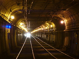
The Twin Peaks Tunnel is a 2.27-mile-long (3.65 km) light rail/streetcar tunnel in San Francisco, California. The tunnel runs under Twin Peaks and is used by the K Ingleside, M Ocean View and S Shuttle lines of the Muni Metro system.
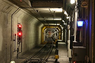
The Market Street subway is a two-level subway tunnel that carries Muni Metro and BART trains under Market Street in San Francisco, California. It runs under the length of Market Street between Embarcadero station and Castro station. The upper level is used by Muni Metro lines and the lower level is used by BART lines. BART does not run through the whole subway; it turns south and runs under Mission Street southwest of Civic Center/UN Plaza station. The northeastern end of the BART level is connected to the Transbay Tube. On the Muni Metro level, the southwestern end of the Market Street subway connects to the much-older Twin Peaks Tunnel, and the northeastern end connects to surface tracks along the Embarcadero.

The E Embarcadero is a historic streetcar line that is the San Francisco Municipal Railway's second heritage streetcar line in San Francisco, California. Trial service first ran during the Sunday Streets events on The Embarcadero in 2008. The line initially ran on weekends only, but expanded to weeklong service in late April 2016.

Van Ness Bus Rapid Transit is a bus rapid transit (BRT) corridor on Van Ness Avenue in San Francisco, California, United States. The 1.96-mile (3.15 km) line, which runs between Mission Street and Lombard Street, has dedicated center bus lanes and nine stations. It was built as part of the $346 million Van Ness Improvement Project, which also included utility replacement and pedestrian safety features. Van Ness Bus Rapid Transit is used by several San Francisco Municipal Railway (Muni) lines including the 49 Van Ness–Mission, as well as three Golden Gate Transit routes.
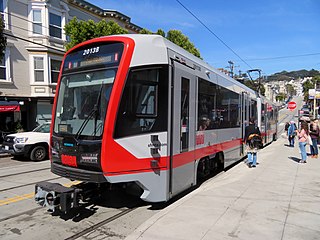
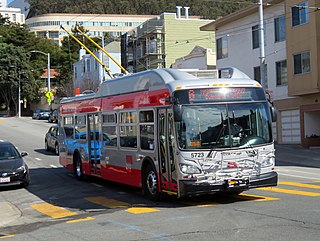
With five different modes of transport the San Francisco Municipal Railway runs one of the most diverse fleets of vehicles in the United States. Roughly 550 diesel-electric hybrid buses, 300 electric trolleybuses, 250 modern light rail vehicles, 50 historic streetcars and 40 cable cars see active duty.

Taraval and 26th Avenue is a light rail stop on the Muni Metro L Taraval line, located in the Parkside neighborhood of San Francisco, California. The station opened with the first section of the L Taraval line on April 12, 1919; irregular shuttle service had run on a United Railroads line since around 1910.

Taraval and 40th Avenue is a light rail stop on the Muni Metro L Taraval line, located in the Parkside neighborhood of San Francisco, California, United States. The station opened with the second section of the L Taraval line on January 14, 1923.

Market and Noe station is a light rail stop in San Francisco, California, United States, serving the San Francisco Municipal Railway F Market & Wharves heritage railway line. It is located on Market Street at the intersections of 16th Street and Noe Street.

Market and Sanchez station is a light rail station in San Francisco, California, United States, serving the San Francisco Municipal Railway F Market & Wharves heritage railway line. It is located on Market Street at the intersections of 15th Street and Sanchez Street.

Market and Dolores (eastbound) and Market and Buchanan (westbound) are a pair of one-way light rail stations in San Francisco, California, United States, serving the San Francisco Municipal Railway F Market & Wharves heritage railway line. They are located on Market Street at the intersections with Dolores Street and Buchanan Street.
6 Haight/Parnassus is a trolleybus line operated by the San Francisco Municipal Railway (Muni). It connects the Financial District to the Inner Sunset and Forest Hill via Haight-Ashbury.

