
The Santa Clara Valley Transportation Authority, more commonly known simply as the Valley Transportation Authority (VTA), is a special district responsible for public transit services, congestion management, specific highway improvement projects, and countywide transportation planning for Santa Clara County, California. It serves San Jose, California, and the surrounding Silicon Valley. It is one of the governing parties for the Caltrain commuter rail line that serves the county. In 2023, the VTA's public transportation services had a combined ridership of 26,610,000, or about 91,400 per weekday as of the second quarter of 2024.

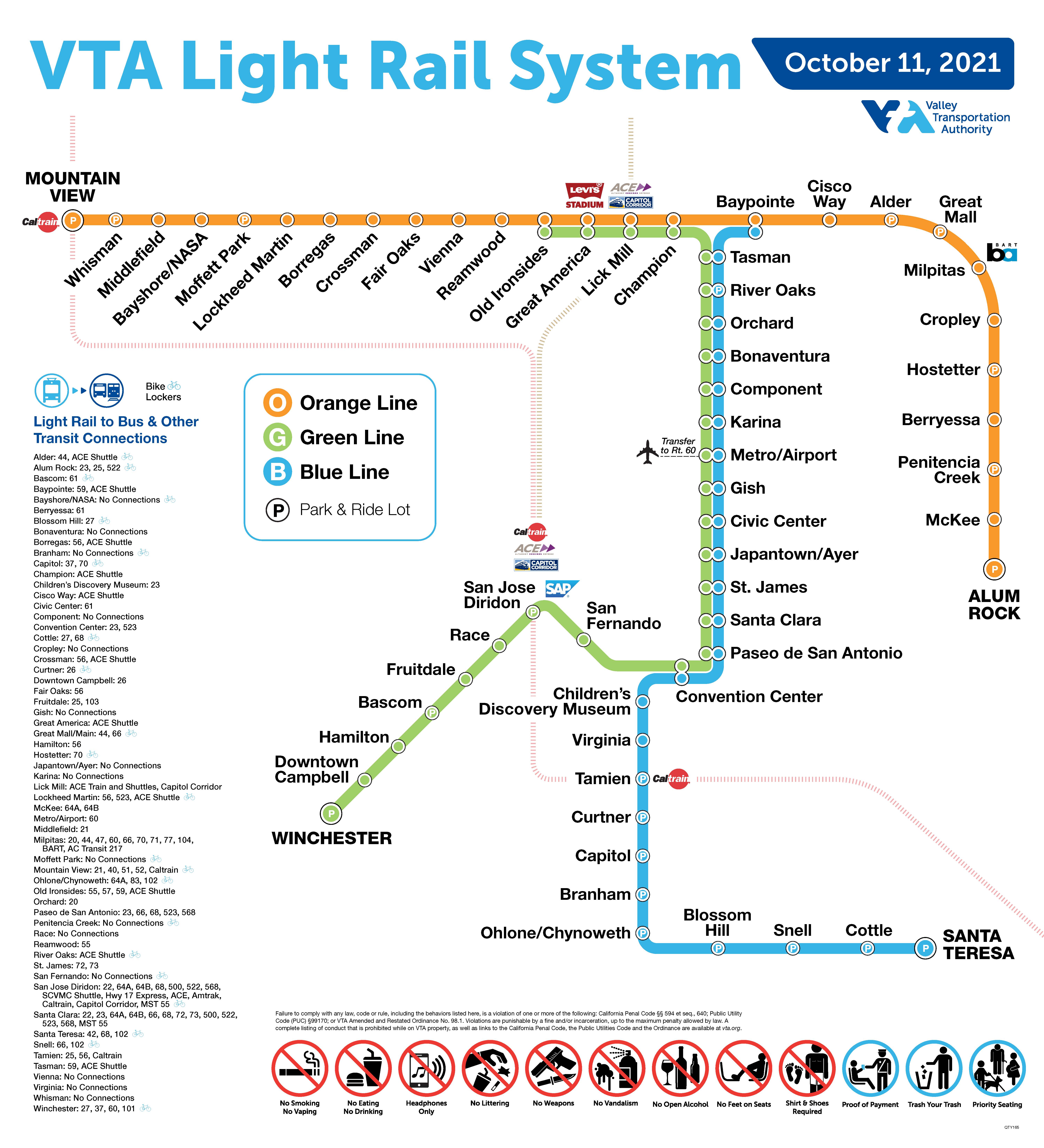
The Blue Line is a light rail line in Santa Clara County, California, and part of the Santa Clara Valley Transportation Authority (VTA) light rail system. It serves 26 stations entirely in San Jose proper, traveling between Baypointe and Santa Teresa stations, stopping at San Jose International Airport, Downtown San Jose, San Jose State University, and the Children's Discovery Museum of San Jose along the way. The line connects to Caltrain at Tamien. The Blue Line is one of three lines in the VTA light rail system; the other two being the Green Line and the Orange Line.

Orchard station is an at-grade light rail station located in the center median of First Street at its intersection with Orchard Parkway, after which the station is named, in San Jose, California. The station is owned by Santa Clara Valley Transportation Authority (VTA) and is served by the Blue Line and the Green Line of the VTA light rail system.

River Oaks station is an at-grade light rail station located in the center median of First Street at its intersection with River Oaks Parkway, after which the station is named, in San Jose, California. The station is owned by Santa Clara Valley Transportation Authority (VTA) and is served by the Blue Line and the Green Line of the VTA light rail system.
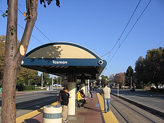
Tasman station is an at-grade light rail station located in the center median of First Street at its intersection with Tasman Drive, after which the station is named, in San Jose, California. The station is owned by Santa Clara Valley Transportation Authority (VTA) and is served by the Blue Line and the Green Line of the VTA light rail system. This is the northernmost station served by both the Blue and Green lines and serves as one of the primary transfer points between the two lines.

Children's Discovery Museum station is an at-grade light rail station on the Blue Line of the VTA light rail system. The station platform runs along Woz Way and serves the Children's Discovery Museum of San Jose, after which the station is named. Just south of this station, the Blue Line enters the median of California State Route 87.

Hostetter station is a light rail station in San Jose, California, United States. It is operated by the Santa Clara Valley Transportation Authority (VTA) and is served by the Orange Line.

Berryessa station is a light rail station operated by Santa Clara Valley Transportation Authority (VTA). This station is served by VTA's Orange Line.

Penitencia Creek station is a light rail station operated by Santa Clara Valley Transportation Authority (VTA). This station is served by VTA's Orange Line.

McKee station is a light rail station operated by Santa Clara Valley Transportation Authority (VTA). This station is served by VTA's Orange Line.

Alum Rock Transit Center is an at-grade intermodal transit center located at the intersection of South Capitol Avenue and Nuestra Castillo Court in the Alum Rock district of San Jose, California. The light rail station is located in the center median of South Capitol Avenue and is the current eastern terminus for the Orange Line of the VTA light rail system. VTA buses serve the transit center both on South Capitol Avenue and in a nearby bus plaza located adjacent to the light rail station.

Tamien station is an intermodal passenger transportation station in the Tamien neighborhood of central San Jose, California, served by the VTA light rail and the Caltrain commuter rail line, along with bus connections. The station has two elevated island platforms, one for each service. The two platforms are connected by a walkway at ground-level that is below the two platforms. The light rail platform is located in the center median of the State Route 87 freeway just north of the Alma Avenue overpass. The Caltrain platform is located just to the east, between Lick Avenue and State Route 87 and just north of Alma Avenue.

Curtner station is a light rail station operated by Santa Clara Valley Transportation Authority (VTA). Curtner station is served by the Blue Line of the VTA light rail system. The station is located within the median of State Route 87, where it crosses over Curtner Avenue in San Jose, California.

Capitol station is a light rail station operated by Santa Clara Valley Transportation Authority (VTA). Capitol station is served by the Blue Line of the VTA light rail system. The Capitol is located in the median of State Route 87, near the intersection with Capitol Expressway in San Jose, California.

Blossom Hill station is a light rail station operated by Santa Clara Valley Transportation Authority (VTA). The station is served by the Blue Line of the VTA light rail system. Blossom Hill station is located in the median of State Route 85, just north of Blossom Hill Road in San Jose, California. It was part of the original Guadalupe Line, the first segment of light rail from Santa Teresa to Tasman.

Snell station is a light rail station operated by Santa Clara Valley Transportation Authority (VTA). The station is served by the Blue Line of the VTA light rail system. It was part of the original Guadalupe Line, the first segment of light rail from Santa Teresa to Tasman. Snell station is located in the median of State Route 85, near Snell Avenue in the southern part of San Jose, California.
Cottle station is a light rail station operated by Santa Clara Valley Transportation Authority (VTA). The station is served by the Blue Line of the VTA light rail system. It was part of the original Guadalupe Line, the first segment of light rail from Santa Teresa to Tasman.
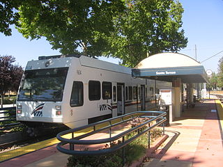
Santa Teresa station is a light rail station operated by Santa Clara Valley Transportation Authority (VTA). This station is the southern terminus of the Blue Line of the VTA light rail system. It was built in the late 1980s as part of the original Guadalupe Line, the first segment of light rail that stretched to Tasman in northern San Jose.

The VTA light rail system serves San Jose and nearby cities in Santa Clara County, California. It is operated by the Santa Clara Valley Transportation Authority (VTA) and has 42.2 miles (67.9 km) of network comprising three main lines on standard gauge tracks. Originally opened on December 11, 1987, the light rail system has expanded since then, and currently has 60 stations in operation.

Ohlone/Chynoweth station is a light rail station on the VTA light rail system. The station is served by the system's Blue Line.

