South San Francisco station (Caltrain)

Last updated
South San Francisco
South San Francisco Caltrain station from Grand Avenue overpass.jpg
A northbound train at South San Francisco station in 2021
General information
Location590 Dubuque Avenue
South San Francisco, California
Coordinates 37°39′18.0″N122°24′21.5″W / 37.655000°N 122.405972°W / 37.655000; -122.405972
Owned by Peninsula Corridor Joint Powers Board
Line(s) Peninsula Subdivision [1]
Platforms1 island platform
Tracks5
ConnectionsAiga bus trans.svg Commute.org: Genesis One Tower Place, Oyster Point, Utah-Grand
Aiga bus trans.svg SamTrans: 38, 130, 141, 292, 397
Construction
Parking81 spaces; paid
Bicycle facilities24 racks, 12 lockers
AccessibleYes
Other information
Fare zone1
History
Opened1909
Rebuilt2017-2022
Electrified2024 (planned)
Passengers
2018468 per weekday [2] Decrease2.svg 8.9%
Services
Preceding station Caltrain roundel.svg Caltrain Following station
Bayshore Local (L1) San Bruno
Weekend Local (L2)
San Francisco
Terminus
Limited (L3) Millbrae
22nd Street
(reverse peak)
      Limited (L4) does not stop here
      Limited (L5) does not stop here
      Baby Bullet (B7) does not stop here
Location
South San Francisco station (Caltrain)

South San Francisco station is a Caltrain station in South San Francisco, California. The station is on the east side of the Bayshore Freeway (U.S. 101), east and south of the curved Grand Avenue overpass, and north of where the freeway crosses over the tracks. Downtown South San Francisco is to the west, across the freeway. It previously underwent a substantial modernization and expansion project, completed in January 2022. [3] [4]

Contents

Station layout

Looking south along the station platform. The mural Prometheus Brings Fire to Man by artist Nicolai Larsen is partially visible at right. South San Francisco Caltrain station platform looking south.jpg
Looking south along the station platform. The mural Prometheus Brings Fire to Man by artist Nicolai Larsen is partially visible at right.
The northern end of the station platform, underneath the Grand Avenue overpass. The pedestrian crossing is at the far end, and the parking lot is behind the fence on the left. North end of South San Francisco Caltrain station platform.jpg
The northern end of the station platform, underneath the Grand Avenue overpass. The pedestrian crossing is at the far end, and the parking lot is behind the fence on the left.

The station features a single island platform. The main entrance is an underpass that connects the south end of the platform to Grand Avenue and Airport Boulevard on the west and East Grand Avenue and Poletti Way on the east. [4] The west approach, providing direct access to the station from downtown South San Francisco, features a plaza with decorative lighting, and the east approach features an area for shuttle buses to pick up and drop off passengers. [5] Passengers can also use a signalized and gated grade crossing (across the southbound track) between the parking lot on Dubuque Avenue and the north end of the platform. Automobiles can enter the parking lot by turning from the Grand Avenue overpass north onto Dubuque, just east of U.S. 101. A tall metal staircase descends to the parking lot from the Grand Avenue overpass at the intersection with Dubuque, though the more direct pedestrian underpass has obviated the need for passengers to use it. Several SamTrans routes stop near the western underpass entrance on Airport Boulevard. [6] The south end of the parking lot features a large mural on the retaining wall for Grand Avenue entitled Prometheus Brings Fire to Man by artist Nicolai Larsen, painted in 1996.

History

A depot for South San Francisco was built in 1909 shortly after the completion of the Bayshore Cutoff, with an entrance on Grand Avenue. [7] [8] Prior to that, a smaller station existed at least as early as 1898. [9] The 1909 building was demolished in the late 1950s to make room for the Bayshore Freeway and replaced with a smaller brick building with an entrance off Dubuque. [10] [11] This building was demolished in the 1990s, though the platform remained in use. [12] From 2017 to 2022, the station was completely reconstructed and relocated several hundred feet south of the prior location. [5] The current station opened in September 2021, though amenities such as the pedestrian underpass and shuttle boarding area on Poletti Way were not completed until January 2022. [3] [4]

Former station

Prior to the new station's opening, a southbound train holds outside the station while passengers board a northbound train Hold out rule at South San Francisco station, July 2018.JPG
Prior to the new station's opening, a southbound train holds outside the station while passengers board a northbound train

The previous station was built before the Bayshore Freeway [7] and retained many of the aspects common to older, unmodernized stations along the Peninsula Commute: the platforms were not accessible-compliant, and riders seeking to board a northbound train had to wait for the train to come to a complete stop before crossing the southbound track to a narrow boarding platform between the tracks. [13] This necessitated the so-called "hold-out" rule (GCOR 6.30)if a train was stopped for passengers, an approaching train on the other track had to wait outside the station. [14] [15] In 2012, a southbound Baby Bullet express train passing through the station narrowly avoided striking passengers for a northbound train stopped at South San Francisco. The Baby Bullet express did not have a scheduled stop at the station and had ignored the hold-out rule. [16]

South San Francisco was the only hold-out rule station with regular service on weekdays (Broadway is open only on weekends, Atherton was open only on weekends until its closure in 2020, and College Park only has limited weekday service tailored to Bellarmine Prep opening and closing times), making it a bottleneck for rail traffic. [4] The hold-out rule was finally lifted for South San Francisco when the new station platform opened in September 2021. [4]

Modernization

South San Francisco station (Caltrain)
2017 – 2022 South San Francisco station improvements  Former  Current 
1
Former station platform under Grand Avenue overpass
2
Rebuilt platform
3
East underpass entrance & shuttle plaza
4
West underpass entrance & downtown plaza

In 1998, the City of South San Francisco prepared a concept plan to relocate the station southward so that trains would stop south of the Grand Avenue overpass in order to improve bus and pedestrian access to the station. This would allow buses currently stopping on Airport Boulevard (west of the Bayshore Freeway and the station) to directly service the station and open up access from the east for employer-provided and Commute.org shuttles. [6] [17]

In 2012 Caltrain and the City of South San Francisco began work on a Downtown Station Area Plan to redevelop the area around the station and make it easier to reach downtown from the station. The plan called for updating the station by renovating the southbound platform and extending it south, and building a new northbound platform to eliminate the "hold out" rule and to be accessible-compliant. It included a new 700 foot (210 m)-long island platform (between northbound and southbound tracks), a bus and shuttle drop-off area on Poletti Way, and an accessible-compliant pedestrian underpass to the new platform to connect with East Grand Avenue/Poletti Way (on the east) and Grand Avenue/Airport Boulevard (on the west). [5] The planned west entrance also featured a new pedestrian plaza at the southeast corner of Airport Boulevard and Grand Avenue, on right-of-way previously used as a Caltrans storage yard. [18] [19] A new pedestrian gate crossing at the northern end of the new platform would provide access to the existing parking lot. [20]

The plan was approved in February 2015 [18] and was to be funded by $49.1 million in funds provided by San Mateo County Measure A, a half-cent sales tax approved by county voters in 2012. [21] Peninsula Corridor Joint Powers Board contributed $4 million and South San Francisco contributed $9.2 million, including $3.3M to expand station property and remediate soil. [22]

Although construction was scheduled to begin in 2016, [23] the design was not finalized until December 2016, [5] and groundbreaking for the modernization project was held on November 6, 2017 in a ceremony attended by State Senator Jerry Hill and South San Francisco Mayor Pradeep Gupta. [22] The new station was projected to open in 2019, [5] [23] but was delayed to August 2020 after planned underground utility relocation work was determined to be a prerequisite for construction of the new pedestrian underpass. [24] it was further delayed to summer 2021, then November 2021, and finally January 2022 due to the coronavirus pandemic. [3] [5]

Related Research Articles

<span class="mw-page-title-main">Caltrain</span> California commuter rail line

Caltrain is a California commuter rail line serving the San Francisco Peninsula and Santa Clara Valley. The southern terminus is in San Jose at Tamien station with weekday rush hour service running as far as Gilroy. The northern terminus of the line is in San Francisco at 4th and King Streets. Caltrain has 28 regular stops, one limited-service weekday-only stop, one weekend-only stop (Broadway), and one football-only stop (Stanford). While average weekday ridership in 2019 exceeded 63,000, impacts of the COVID-19 pandemic have been significant: in August 2022, Caltrain had an average weekday ridership of 18,600 passengers.

<span class="mw-page-title-main">Third Street Light Rail Project</span> San Francisco Muni tram line

The Third Street Light Rail Project was the construction project that expanded the Muni Metro system in San Francisco, California, linking downtown San Francisco to the historically underserved southeastern neighborhoods of Bayview-Hunters Point and Visitacion Valley along the eastern side of the city. Construction was finished in late 2006, non-revenue weekend service began on January 13, 2007, and full service began on April 7, 2007. The new service, as the T Third Street Metro line, replaced the 15 Third bus line, which ran south from the Caltrain Depot at 4th and King streets, along Third Street and Bayshore Boulevard to the southeastern neighborhoods.

<span class="mw-page-title-main">Balboa Park station</span> Transit station in San Francisco, California, US

Balboa Park station is a Bay Area Rapid Transit (BART) station and Muni Metro complex in the Mission Terrace neighborhood of San Francisco, California, located near the eponymous Balboa Park. It is an intermodal hub served by four BART routes, three Muni Metro lines, and a number of Muni bus routes. The station complex also includes two rail yards, Cameron Beach Yard and Green Light Rail Center, where Muni maintains Muni Metro trains and heritage streetcars. BART uses a below-grade island platform on the west side of the complex; Muni Metro routes use several smaller side platforms located on surface-level rail loops around the yards.

<span class="mw-page-title-main">Millbrae station</span> Train station in Millbrae, California, U.S.

Millbrae station is an intermodal transit station serving Bay Area Rapid Transit (BART) and Caltrain, located in Millbrae, California. The station is the terminal station for BART on the San Francisco Peninsula, served by two lines: The Red Line before 9 pm and the Yellow Line during the early morning and evening. It is served by all Caltrain services. The station is also served by SamTrans bus service, Commute.org and Caltrain shuttle buses, and other shuttles.
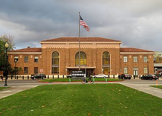
<span class="mw-page-title-main">Downtown Mountain View station</span> Train station in Mountain View, California, U.S.

Downtown Mountain View station is an intermodal transit station providing public bus and rail service, located in Mountain View, California. The station is served by the Caltrain commuter rail service, for which it is simply called Mountain View station. Santa Clara VTA Orange Line light rail service is provided to an adjacent, dedicated light rail facility, known as Downtown Mountain View station. VTA local transit bus and employer-operated shuttle services are accommodated from the Mountain View Transit Center on the Evelyn Avenue side of the station.

<span class="mw-page-title-main">Santa Clara Transit Center</span> Train station in Santa Clara, California, U.S.

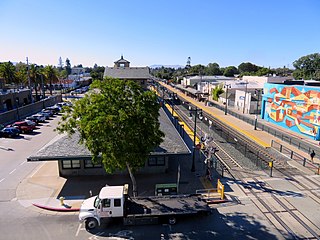
Santa Clara Transit Center is a railway station in downtown Santa Clara, California. It is served by Caltrain, Amtrak Capitol Corridor, and Altamont Corridor Express (ACE) trains. It is the planned terminus for the Silicon Valley BART extension into Santa Clara County. The former station building, constructed in 1863 by the San Francisco and San Jose Railroad, is used by the Edward Peterman Museum of Railroad History.

<span class="mw-page-title-main">Palo Alto station</span> Train station in Palo Alto, California, U.S.

Palo Alto station is an intermodal transit center in Palo Alto, California. It is served by Caltrain regional rail service, SamTrans and Santa Clara VTA local bus service, Dumbarton Express regional bus service, the Stanford University Marguerite Shuttle, and several local shuttle services. Palo Alto is the second-busiest Caltrain station after San Francisco, averaging 7,764 weekday boardings by a 2018 count. The Caltrain station has two side platforms serving the two tracks of the Peninsula Subdivision and a nearby bus transfer plaza.

<span class="mw-page-title-main">22nd Street station (Caltrain)</span> Train station in San Francisco, California, U.S.

22nd Street station is a Caltrain commuter rail station located south of 22nd Street between the Dogpatch and Potrero Hill neighborhoods of San Francisco, California beneath the Interstate 280 freeway viaduct. The only below-grade Caltrain station, it is bracketed on the north and south by two tunnels which take the line under the eastern slope of Potrero Hill. The station is also served by Muni routes 48 and 55.

<span class="mw-page-title-main">Bayshore station (Caltrain)</span> Train station in San Francisco, California, U.S.

Bayshore station is a Caltrain commuter rail station in the Visitacion Valley neighborhood of San Francisco, California. The station is on the border of San Francisco and the neighboring city of Brisbane. The parking lot and the northern section of the station are in San Francisco, while the remainder is in Brisbane. The station address is in San Francisco proper.

<span class="mw-page-title-main">San Bruno station (Caltrain)</span> Train station in San Bruno, California, U.S.

San Bruno station is a Caltrain station located in San Bruno, California. The station is located just northeast of downtown San Bruno, above the intersection of San Mateo and San Bruno Avenues, adjacent to Artichoke Joe's Casino.

<span class="mw-page-title-main">Broadway station (Caltrain)</span> Train station in Burlingame, California, U.S.

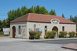
Broadway station is a Caltrain station in Burlingame, California. Caltrain only serves the stop on weekends and holidays; weekday service is provided by a bus shuttle to nearby Millbrae station.

<span class="mw-page-title-main">San Mateo station</span> Train station in San Mateo, California, U.S.

San Mateo station is the northernmost of the three Caltrain stations in San Mateo, California. It is in downtown San Mateo.

<span class="mw-page-title-main">Hillsdale station (Caltrain)</span> Train station in San Mateo, California, U.S.

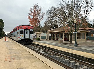
Hillsdale station is one of three Caltrain stations in San Mateo, California. The station is next to the Bay Meadows neighborhood and close to the Hillsdale Shopping Center.

<span class="mw-page-title-main">Atherton station</span>

Atherton station is a former Caltrain station in Atherton, California. The station had one side platform and one island platform serving the two tracks of the Peninsula Subdivision, with a concrete and wooden shelter on the west side of the tracks. The station opened by the Southern Pacific Railroad in 1866 as Fair Oaks and was renamed Atherton in 1912. Caltrain cut weekday service to the station in 2005 due to low ridership and a hold-out rule that prohibited two trains from being at the station simultaneously. Weekend service continued until December 2020.

<span class="mw-page-title-main">Paul Avenue station</span>

Paul Avenue was a Caltrain station located in the Bayview neighborhood of San Francisco, California. The lightly used station was closed on August 1, 2005, and the platform and shelter were removed in 2009. A replacement station to the north has been proposed.

<span class="mw-page-title-main">California Avenue station</span> Train station in Palo Alto, California, U.S.

California Avenue station is a Caltrain station located in Palo Alto, California. It stops at the historical town center of Mayfield, which was annexed by the town of Palo Alto in 1925. The current station structure was built in 1983 and the station was expanded from one platform to two in 2008.

<span class="mw-page-title-main">Arleta station</span> Rail stop in San Francisco

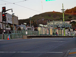
Arleta station is a light rail station on the Muni Metro T Third Street line in the Visitacion Valley neighborhood of San Francisco, California on the south slope of Candlestick Hill. The station opened with the T Third Street line on January 13, 2007. It has a single island platform located in the median of Bayshore Boulevard between Arleta Avenue and Blanken Avenue, with access from crosswalks at both streets.

<span class="mw-page-title-main">Caltrain Express</span> Faster San Francisco-San Jose rail service

The Caltrain Express (CTX) project was implemented from 2002 to 2004 and led to the establishment of the Baby Bullet express service, which shortened the transit time between San Francisco and San Jose, and certain stations in between. New locomotives and rolling stock were purchased for dedicated express service, bypassing most stations; quad-track overtake sections were added in two locations along the Peninsula Corridor right-of-way to allow express trains to pass slower local trains that were making all stops; tracks were also upgraded with continuous-welded rail; a centralized traffic control system was added; and crossovers were added every few miles to allow single-tracking trains around disabled trains. Congresswoman Jackie Speier, then serving as a California State Senator, is credited with securing the funding for CTX and one of the new locomotives acquired for the project is named for her as a result. During commute hours, the Baby Bullet is up to 20% faster than driving south from San Francisco to San Jose.

The Downtown Rail Extension (DTX) is a planned second phase of the San Francisco Transbay Transit Center (TTC). When complete, it will extend the Caltrain Peninsula Corridor commuter rail line from its current northern terminus at 4th and King via a 1.3 mi (2.1 km) tunnel. The new terminus will be near the Financial District and will provide intermodal connections to BART, Muni, Transbay AC Transit buses, and long-distance buses. In addition, the California High Speed Rail Authority (CHSRA) plans to use DTX and the Caltrain-owned Peninsula Corridor for service on the CHSRA San Francisco–San Jose segment. Because DTX uses a long tunnel, current diesel locomotives are not suitable and the Caltrain Modernization Project (CalMod), which includes electrification of the line and acquisition of electrified rolling stock, is a prerequisite.

References

  1. SMA Rail Consulting (April 2016). "California Passenger Rail Network Schematics" (PDF). California Department of Transportation. p. 13.
  2. "2018 Annual Count Key Findings Report" (PDF). Caltrain. 2018. Archived from the original (PDF) on 2020-05-20. Retrieved 2018-10-17.
  3. 1 2 3 "South San Francisco Caltrain Station to Open in November". www.caltrain.com. Retrieved 2021-07-09.
  4. 1 2 3 4 5 "South San Francisco Station Improvement Project". www.caltrain.com. Retrieved 2022-01-19.
  5. 1 2 3 4 5 6 "South San Francisco Caltrain Station Improvement Project". Caltrain/JPB. 2016. Retrieved 20 January 2017.
  6. 1 2 "4: Transportation". South San Francisco General Plan (Report). City of South San Francisco. 2014. pp. 4–34, 4–35. Retrieved 20 January 2017.
  7. 1 2 "South San Francisco To Have A New S.P. Station". San Francisco Call. Vol. 102, no. 84. 23 August 1907. Retrieved 20 January 2017.
  8. "Southern Pacific Railroad depot". Bits of History. Peninsula Library System. 1909. Retrieved 24 May 2018.
  9. "Southern Pacific Railroad Station". Bits of History. Peninsula Library System. 1898. Retrieved 24 May 2018.
  10. "Southern Pacific Railroad station". Bits of History. Peninsula Library System. 1961. Retrieved 24 May 2018.
  11. "Southern Pacific Railroad station". Bits of History. Peninsula Library System. 1967. Retrieved 24 May 2018.
  12. "The old brick depot at South San Francisco. It was demolished in the 1990s. #Caltrain | South san francisco, Old bricks, House styles". Pinterest. Caltrain. Retrieved 2021-10-12.
  13. "South San Francisco Station". Caltrain. 2016. Retrieved 20 January 2017.
  14. GCOR: General Code of Operating Rules (PDF). West Coast Railroaders Group (Report) (6th ed.). General Code of Operating Rules Committee. 2010. pp. 6–15. Archived from the original (PDF) on 1 February 2016. Retrieved 20 January 2017.
  15. "San Francisco to San Jose Glossary of Terms" (PDF). California High-Speed Rail Authority / Caltrain JPB. 18 February 2010. Retrieved 20 January 2017. Hold-Out Rule The rule enforced at Caltrain stations that have only one outside boarding platform which prevents a train from entering the station while another train [is] at the station boarding or alighting passengers. Platform upgrades will allow the hold-out rule to be eliminated, either by adding a second outside boarding platform on the opposite side, or by replacing the existing platform with a center-boarding platform.
  16. Rosenberg, Mike (14 September 2012). "Terrified Caltrain passengers forced to jump out of way of train". San Mateo County Times. Retrieved 20 January 2017.
  17. "South San Francisco Caltrain Relocation Study". Dyett & Bhatia: Urban and Regional Planners. 1998. Retrieved 20 January 2017.
  18. 1 2 "South San Francisco Downtown Station Area Specific Plan". City of South San Francisco. February 2015. Retrieved 6 November 2016.
  19. "South San Francisco applies for grant funding for pedestrian/bike tunnel to Caltrain". Green Caltrain. 24 October 2013. Retrieved 6 November 2013.
  20. "South San Francisco Station Improvement Project" (PDF). Caltrain. 24 October 2018. Retrieved 21 January 2019.
  21. emmas (13 February 2015). "South San Francisco Downtown Plan and new Caltrain station approved". Silicon Valley Bicycle Coalition blog. Silicon Valley Bicycle Coalition. Retrieved 20 November 2015.
  22. 1 2 Walsh, Austin (7 November 2017). "New Caltrain station construction arrives". San Mateo Daily Journal. Retrieved 7 November 2017.
  23. 1 2 Futrell, Mike (9 February 2015). "Major Improvements Slated for South San Francisco Caltrain Station" (Press release). City of South San Francisco. Retrieved 29 January 2016.
  24. "South San Francisco Station Improvement Project" (PDF). Peninsula Corridor Joint Powers Board. September 2018. Retrieved 4 September 2018.