
South San Francisco is a city in San Mateo County, California, United States, on the San Francisco Peninsula in the San Francisco Bay Area. Its location has been populated for more than five thousand years. The city is colloquially termed "South City". The population was 66,105 at the 2020 census.

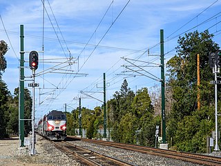
Caltrain is a California commuter rail line serving the San Francisco Peninsula and Santa Clara Valley. The southern terminus is in San Jose at Tamien station with weekday rush hour service running as far as Gilroy. The northern terminus of the line is in San Francisco at 4th and King Street. Caltrain has 28 regular stops, one limited-service weekday-only stop, one weekend-only stop (Broadway), and one football-only stop (Stanford). While average weekday ridership in 2019 exceeded 63,000, impacts of the COVID-19 pandemic have been significant: in August 2022, Caltrain had an average weekday ridership of 18,600 passengers.
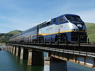
The Capitol Corridor is a 168-mile (270 km) passenger train route in Northern California operated by Amtrak between San Jose, in the Bay Area, and Auburn, in the Sacramento Valley. The route is named after the two points most trains operate between, San Jose and Sacramento. The route runs roughly parallel to I-880 and I-80. Some limited trips run between Oakland and San Jose. A single daily round trip runs between San Jose and Auburn, in the foothills of the Sierra Nevada. Capitol Corridor trains started in 1991.

SamTrans is a public transport agency in and around San Mateo, California, in the San Francisco Bay Area. It provides bus service throughout San Mateo County and into portions of San Francisco and Palo Alto. SamTrans also operates commuter shuttles to BART stations and community shuttles. Service is largely concentrated on the east side of the Santa Cruz Mountains, and, in the central county, I-280, leaving coast-side service south of Pacifica spotty and intermittent.

The MBTA ferry system is a public boat service providing water transportation in Boston Harbor. It is operated by Hornblower Cruises under contract to the Massachusetts Bay Transportation Authority (MBTA). In 2023, the system had a ridership of 1,260,000, or about 300 per weekday as of the first quarter of 2024. The system has six routes that terminate in downtown Boston. Year-round routes run to Hingham directly (F1) and via Hull (F2H), and to the Charlestown Navy Yard (F4). Seasonal routes run to Lynn (F3), Winthrop (F5), and East Boston (F6).

Millbrae station is an intermodal transit station serving Bay Area Rapid Transit (BART) and Caltrain, located in Millbrae, California. The station is the terminal station for BART on the San Francisco Peninsula, served by two lines: The Red Line before 9 pm and the Yellow Line during the early morning and evening. It is served by all Caltrain services. The station is also served by SamTrans bus service, Commute.org and Caltrain shuttle buses, and other shuttles.

People in the San Francisco Bay Area rely on a complex multimodal transportation infrastructure consisting of roads, bridges, highways, rail, tunnels, airports, seaports, and bike and pedestrian paths. The development, maintenance, and operation of these different modes of transportation are overseen by various agencies, including the California Department of Transportation (Caltrans), the Association of Bay Area Governments, San Francisco Municipal Transportation Agency, and the Metropolitan Transportation Commission. These and other organizations collectively manage several interstate highways and state routes, eight passenger rail networks, eight trans-bay bridges, transbay ferry service, local and transbay bus service, three international airports, and an extensive network of roads, tunnels, and bike paths.

The Peninsula Commute, also known as the Southern Pacific Peninsula or just Peninsula, was the common name for commuter rail service between San Jose, California and San Francisco, California on the San Francisco Peninsula. This service ran as a private, for-profit enterprise beginning in 1863. Due to operating losses, the Southern Pacific Railroad (SP) petitioned to discontinue the service in 1977. Subsidies were provided through the California Department of Transportation (Caltrans) in 1980 to continue service, and it was renamed Caltrain.

San Francisco Bay in California has been served by ferries of all types for over 150 years. John Reed established a sailboat ferry service in 1826. Although the construction of the Golden Gate Bridge and the San Francisco–Oakland Bay Bridge led to the decline in the importance of most ferries, some are still in use today for both commuters and tourists.

Golden Gate Ferry is a commuter ferry service operated by the Golden Gate Bridge, Highway and Transportation District in San Francisco Bay, part of the Bay Area of Northern California, United States. Regular service is run to the Ferry Building in San Francisco from Larkspur, Sausalito, Tiburon, and Angel Island in Marin County, with additional service from Larkspur to Oracle Park and Chase Center. The ferry service is funded primarily by passenger fares and Golden Gate Bridge tolls. In 2023, Golden Gate Ferry had a ridership of 1,299,200, or about 3,500 per weekday as of the first quarter of 2024.

San Francisco Bay Ferry is a public transit passenger ferry service in the San Francisco Bay, administered by the San Francisco Bay Area Water Emergency Transportation Authority (WETA) and operated under contract by the privately owned, Blue and Gold Fleet. In 2023, the system had a ridership of 2,230,400, or about 6,300 per weekday as of the first quarter of 2024.
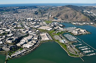
Oyster Point Marina/Park is a 408-berth public marina and 33-acre (13 ha) park located in the city of South San Francisco, California on the western shoreline of San Francisco Bay.

Hercules station is a proposed intermodal infill train station and ferry terminal in Hercules, California in Contra Costa County. It is to be the first direct Amtrak-to-ferry transit hub in the San Francisco Bay Area and will be constructed in between the existing Richmond and Martinez stations. By July 2018, three of the station's six construction phases had been complete, including street at Bay Trail approaches. However, no proposed opening date has yet been announced by the City of Hercules.

Butler Road station was a train station in South San Francisco, California, in operation until July 1983 on the Peninsula Commute, a commuter rail service run by Southern Pacific between San Francisco and communities on the San Francisco Peninsula. The Butler Road train shelter was built in 1926.
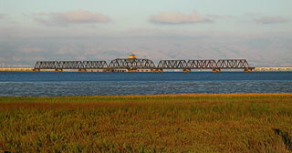
The Dumbarton Rail Corridor is a proposed transbay passenger rail line which would reuse the right-of-way that was initially constructed from 1907–1910 as the Dumbarton Cut-off. The Dumbarton Cut-off includes the first structure to span San Francisco Bay, the 1910 Dumbarton Rail Bridge, although the vintage Cut-off bridges would likely be replaced prior to activating new passenger service. Dumbarton Rail Corridor would provide service between Union City in the East Bay and Menlo Park on the Peninsula, with train service continuing to both San Francisco and San José along the existing Caltrain tracks. It has been in the planning stages since 1988, and would be the first above-ground transbay rail line since Key System electric trains stopped running on the lower deck of the Bay Bridge in 1958, and the first new transbay crossing of any kind since the completion of the Transbay Tube in 1974.

The Caltrain Express (CTX) project was implemented from 2002 to 2004 and led to the establishment of the Baby Bullet express service, which shortened the transit time between San Francisco and San Jose, and certain stations in between. New locomotives and rolling stock were purchased for dedicated express service, bypassing most stations; quad-track overtake sections were added in two locations along the Peninsula Corridor right-of-way to allow express trains to pass slower local trains that were making all stops; tracks were also upgraded with continuous-welded rail; a centralized traffic control system was added; and crossovers were added every few miles to allow single-tracking trains around disabled trains. Congresswoman Jackie Speier, then serving as a California State Senator, is credited with securing the funding for CTX and one of the new locomotives acquired for the project is named for her as a result. During commute hours, the Baby Bullet is up to 20% faster than driving south from San Francisco to San Jose.
The Caltrain Modernization Program (CalMod), sometimes referred to as the Caltrain Electrification Project, is a $2.44 billion project that will add a positive train control (PTC) system and electrify the main line of the U.S. commuter railroad Caltrain, which serves cities in the San Francisco Peninsula and Silicon Valley, as well as transition from its current diesel-electric locomotive powered trains to electric multiple units (EMU). According to Caltrain, electrification of the tracks will allow it to improve service times via faster acceleration and shorter headways, reduce air pollution and noise, and facilitate a future railway tunnel into downtown San Francisco's Transbay Transit Center, as diesel trains cannot serve underground stations.

The Portal, also known as the Downtown Rail Extension (DTX), is a planned second phase of the San Francisco Transbay Transit Center (TTC). When complete, it will extend the Caltrain Peninsula Corridor commuter rail line from its current northern terminus at 4th and King via a 1.3-mile (2.1 km) tunnel. The new terminus will be near the Financial District and will provide intermodal connections to BART, Muni, Transbay AC Transit buses, and long-distance buses. In addition, the California High Speed Rail Authority (CHSRA) plans to use DTX and the Caltrain-owned Peninsula Corridor for service on the CHSRA San Francisco–San Jose segment. Because DTX uses a long tunnel, current diesel locomotives are not suitable and the Caltrain Modernization Project (CalMod), which includes electrification of the line and acquisition of electrified rolling stock, is a prerequisite.
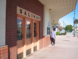
The Monterey County Rail Extension is a planned commuter rail extension that would bring Caltrain passenger service south of its existing Gilroy, California terminus to Salinas in Monterey County, using the existing Coast Line owned by Union Pacific (UPRR). Implementation of the rail extension will occur over three phases, starting from Salinas and moving north. When construction is complete, there will be four trains operated over the extended line per weekday: two northbound trains that depart from Salinas and travel to San Francisco in the morning, and two southbound trains that return to Salinas in the afternoon.

