
Alameda is a city in Alameda County, California, United States, located in the East Bay region of the Bay Area. The city is primarily located on Alameda Island, but also spans Bay Farm Island and Coast Guard Island, as well as a few other smaller islands in San Francisco Bay. As of the 2020 census, the city's population was 78,280.

San Francisco Bay is a large tidal estuary in the U.S. state of California, and gives its name to the San Francisco Bay Area. It is dominated by the cities of San Francisco, San Jose, and Oakland.

The San Francisco–Oakland Bay Bridge, known locally as the Bay Bridge, is a complex of bridges spanning San Francisco Bay in California. As part of Interstate 80 and the direct road between San Francisco and Oakland, it carries about 260,000 vehicles a day on its two decks. It has one of the longest spans in the United States.
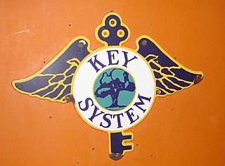
The Key System was a privately owned company that provided mass transit in the cities of Oakland, Berkeley, Alameda, Emeryville, Piedmont, San Leandro, Richmond, Albany, and El Cerrito in the eastern San Francisco Bay Area from 1903 until 1960, when it was sold to a newly formed public agency, AC Transit. The Key System consisted of local streetcar and bus lines in the East Bay, and commuter rail and bus lines connecting the East Bay to San Francisco by a ferry pier on San Francisco Bay, later via the lower deck of the Bay Bridge. At its height during the 1940s, the Key System had over 66 miles (106 km) of track. The local streetcars were discontinued in 1948 and the commuter trains to San Francisco were discontinued in 1958. The Key System's territory is today served by BART and AC Transit bus service.

People in the San Francisco Bay Area rely on a complex multimodal transportation infrastructure consisting of roads, bridges, highways, rail, tunnels, airports, seaports, and bike and pedestrian paths. The development, maintenance, and operation of these different modes of transportation are overseen by various agencies, including the California Department of Transportation (Caltrans), the Association of Bay Area Governments, San Francisco Municipal Transportation Agency, and the Metropolitan Transportation Commission. These and other organizations collectively manage several interstate highways and state routes, eight passenger rail networks, eight trans-bay bridges, transbay ferry service, local and transbay bus service, three international airports, and an extensive network of roads, tunnels, and bike paths.

The East Bay Electric Lines were a unit of the Southern Pacific Railroad that operated electric interurban-type trains in the East Bay region of the San Francisco Bay Area. Beginning in 1862, the SP and its predecessors operated local steam-drawn ferry-train passenger service in the East Bay on an expanding system of lines, but in 1902 the Key System started a competing system of electric lines and ferries. The SP then drew up plans to expand and electrify its system of lines and this new service began in 1911. The trains served the cities of Berkeley, Albany, Emeryville, Oakland, Alameda, and San Leandro transporting commuters to and from the large Oakland Pier and SP Alameda Pier. A fleet of ferry boats ran between these piers and the docks of the Ferry Building on the San Francisco Embarcadero.

The Sacramento Northern Railway was a 183-mile (295 km) electric interurban railway that connected Chico in northern California with Oakland via the California capital, Sacramento. In its operation it ran directly on the streets of Oakland, Sacramento, Yuba City, Chico, and Woodland and ran interurban passenger service until 1941 and freight service into the 1960s.
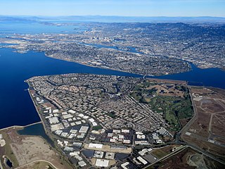
Bay Farm Island is a district of the city of Alameda, California, though it is separated from the rest of the city on Alameda Island by an estuary of San Leandro Bay. Its ZIP code is 94502. The location was originally an island in San Francisco Bay, but due to land reclamation it has become a peninsula and is now connected to the mainland of Oakland and Oakland International Airport. Marshes and other areas of the island were also reclaimed.
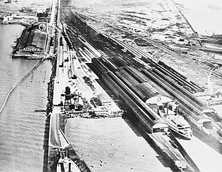
The Oakland Long Wharf was an 11,000-foot railroad wharf and ferry pier along the east shore of San Francisco Bay located at the foot of Seventh Street in West Oakland. The Oakland Long Wharf was built, beginning 1868, by the Central Pacific Railroad on what was previously Oakland Point. Beginning November 8, 1869, it served as the west coast terminus of the First transcontinental railroad. In the 1880s, Southern Pacific Railroad took over the CPRR, extending it and creating a new ferry terminal building with the official station name Oakland Pier. The entire structure became commonly and popularly called the Oakland Mole. Portions of the Wharf lasted until the 1960s. The site is now part of the facilities of the Port of Oakland, while passenger train service operates at the nearby Jack London Square/Dellums Station and another nearby station in Emeryville.

16th Street station is a former Southern Pacific Railroad station in the Prescott neighborhood of Oakland, California, United States. The Beaux-Arts building was designed by architect Jarvis Hunt, a preeminent railroad station architect, and opened in 1912. The station has not been served by trains since 1994.

San Francisco Bay in California has been served by ferries of all types for over 150 years. John Reed established a sailboat ferry service in 1826. Although the construction of the Golden Gate Bridge and the San Francisco–Oakland Bay Bridge led to the decline in the importance of most ferries, some are still in use today for both commuters and tourists.
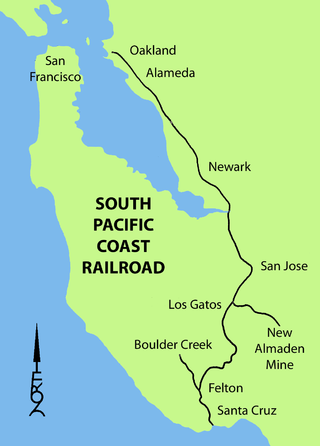
The South Pacific Coast Railroad (SPC) was a 3 ft narrow gauge steam railroad running between Santa Cruz, California and Alameda, with a ferry connection in Alameda to San Francisco. The railroad was created as the Santa Clara Valley Railroad, founded by local strawberry growers as a way to get their crops to market in San Francisco and provide an alternative to the Southern Pacific Railroad. In 1876, James Graham Fair, a Comstock Lode silver baron, bought the line and extended it into the Santa Cruz Mountains to capture the significant lumber traffic coming out of the redwood forests. The narrow-gauge line was originally laid with 52-pound-per-yard (26 kg/m) rail on 8-foot (2.44 m) redwood ties; and was later acquired by the Southern Pacific and converted to 4 ft 8+1⁄2 instandard gauge.

San Francisco Bay Ferry is a public transit passenger ferry service in the San Francisco Bay, administered by the San Francisco Bay Area Water Emergency Transportation Authority (WETA). In 2022, the system had a ridership of 1,787,400, or about 4,500 per weekday as of the fourth quarter of 2022.
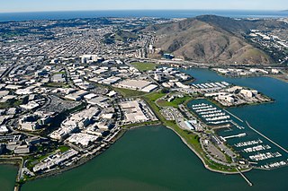
Oyster Point Marina/Park is a 408-berth public marina and 33-acre (13 ha) park located in the city of South San Francisco, California on the western shoreline of San Francisco Bay.
The San Francisco and Oakland Railroad (SF&O) was built in 1862 to provide ferry-train service from a San Francisco ferry terminal connecting with railroad service through Oakland to San Antonio. In 1868 Central Pacific Railroad decided that Oakland would be the west coast terminus of the First transcontinental railroad and bought SF&O. Beginning November 8, 1869, part of the SF&O line served as the westernmost portion of the transcontinental railroad. It subsequently was absorbed into the Southern Pacific Railroad (SP). The track in Oakland was electrified in 1911 and extended across the San Francisco-Oakland Bay Bridge in 1939. Service was abandoned in 1941.
The San Francisco and Alameda Railroad (SF&A) was a short-lived railroad company in the East Bay area of the San Francisco Bay Area. The railroad line opened 1864–1865 from Alameda Terminal on Alameda Island to Hayward, California, with ferry service between Alameda Terminal and San Francisco started in 1864. After being bankrupted by the 1868 Hayward earthquake, it was acquired by a subsidiary of the Central Pacific Railroad in August 1869. Part of the SF&A line between Alameda Terminal and San Leandro served as a portion of the First transcontinental railroad starting in September 1869, while the southern section was abandoned in 1873.
The Western Pacific Railroad (1862–1870) was formed in 1862 to build a railroad from Sacramento, California, to the San Francisco Bay, the westernmost portion of the First transcontinental railroad. After the completion of the railroad from Sacramento to Alameda Terminal on September 6, 1869, and then the Oakland Pier on November 8, 1869, which was the Pacific coast terminus of the transcontinental railroad, the Western Pacific Railroad was absorbed in 1870 into the Central Pacific Railroad.

The South San Francisco Ferry Terminal is the only operating ferry terminal in San Mateo County, California. Boats are operated by San Francisco Bay Ferry and connect the city of South San Francisco to the Oakland Ferry Terminal in Jack London Square as well as Alameda, California. Construction began in 2009 and ferry service started on June 4, 2012. While ferry service between San Francisco and ports to the south existed as far south as San Jose/Alviso during the 1800s, most passengers to Peninsula destinations took the San Francisco and San Jose Railroad after it was completed in 1864 as part of the transcontinental railway.

