Lombard Street is an east–west street in San Francisco, California, that is famous for a steep, one-block section with eight hairpin turns. The street stretches from The Presidio east to The Embarcadero. Most of Lombard Street's western segment is a major thoroughfare designated as part of U.S. Route 101. The famous one-block section, claimed to be "the crookedest street in the world", is located along the eastern segment in the Russian Hill neighborhood. It is a major tourist attraction, receiving around two million visitors per year and up to 17,000 per day on busy summer weekends, as of 2015.
The Golden Era was a 19th-century San Francisco newspaper. The publication featured the writing of Mark Twain, Bret Harte, Charles Warren Stoddard, Fitz Hugh Ludlow, Adah Isaacs Menken, Ada Clare, Prentice Mulford, Dan De Quille, J. S. Hittell and some women such as Frances Fuller Victor. Stoddard recalled the newspaper as "the chief literary organ west of the Rocky Mountains".

The Central Freeway is a roughly one-mile (1.5 km) elevated freeway in San Francisco, California, United States, connecting the Bayshore/James Lick Freeway with the Hayes Valley neighborhood. Most of the freeway is part of US 101, which exits at Mission Street on the way to the Golden Gate Bridge. The freeway once extended north to Turk Street, and initially formed part of a loop around downtown, but was damaged along with the Embarcadero in the 1989 Loma Prieta earthquake; both highways have since been replaced with the surface-level Octavia Boulevard and Embarcadero, respectively.
Montgomery Street is a north-south thoroughfare in San Francisco, California, in the United States.

The Barbary Coast was a red-light district during the second half of the 19th and early 20th centuries in San Francisco that featured dance halls, concert saloons, bars, jazz clubs, variety shows, and brothels. Its nine block area was centered on a three block stretch of Pacific Street, now Pacific Avenue, between Montgomery and Stockton Streets. Pacific Street was the first street to cut through the hills of San Francisco, starting near Portsmouth Square and continuing east to the first shipping docks at Buena Vista Cove.

Kearny Street in San Francisco, California runs north from Market Street to The Embarcadero. Toward its south end, it separates the Financial District from the Union Square and Chinatown districts. Further north, it passes over Telegraph Hill, interrupted by a gap near Coit Tower.

Rincon Hill is a neighborhood in San Francisco, California. It is one of San Francisco's many hills, and one of its original "Seven Hills". The relatively compact neighborhood is bounded by Folsom Street to the north, the Embarcadero to the east, Bryant Street on the south, and Essex Street to the west. Named after Rincon Point that formerly extended into the bay there, Rincon Hill is located just south of the Transbay development area, part of the greater South of Market area. The hill is about 100 feet tall.
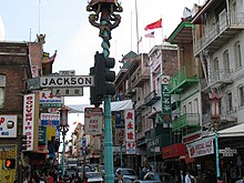
Jackson Square Historic District is an area in downtown San Francisco, California. It dates back to the city's earliest years and the 1849 gold rush, and is known for its historic commercial buildings in the classical revival and Italianate styles.

Hastings Street is one of the most important east-west traffic corridors in the cities of Vancouver and Burnaby, British Columbia, Canada, and used to be a part of the decommissioned Highway 7A. In the central business district of Downtown Vancouver, it is known as West Hastings Street; at Carrall Street it becomes East Hastings Street and runs eastwards through East Vancouver and Burnaby. In Burnaby, there is no east-west designation. The street ends in Westridge, a neighbourhood at the foot of Burnaby Mountain where it joins the recently built Burnaby Mountain Parkway and diverges from the continuation of the former Highway 7A as the Barnet Highway, to Port Moody, British Columbia.

Van Ness Avenue is a north–south thoroughfare in San Francisco, California. Originally named Marlette Street, the street was renamed in honor of the city's sixth mayor, James Van Ness.

Stockton Street is a north-south street in San Francisco. It begins at Market Street passing Union Square, a major shopping district in the city. It then runs underground for about two and a half blocks in the Stockton Street Tunnel, passes through Chinatown and North Beach, and ends at Beach Street near the Pier 39 shopping center and tourist attraction.
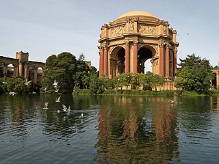
The Marina District is a neighborhood located in San Francisco, California. The neighborhood sits on the site of the 1915 Panama–Pacific International Exposition, staged after the 1906 San Francisco earthquake to celebrate the reemergence of the city. Aside from the Palace of Fine Arts, all other buildings were demolished to make the current neighborhood.
Aubrey Landing, Aubrey City or Aubrey is a ghost town at the mouth of the Bill Williams River in southern Mohave County, Arizona, United States. The town was founded before 1865 and was abandoned sometime after 1886. Aubrey Landing was inundated when Lake Havasu was formed.

Clarion Alley is a small street between Mission and Valencia Streets and 17th and 18th Streets in the Mission District in San Francisco, California. It is notable for the murals painted by the Clarion Alley Mural Project.
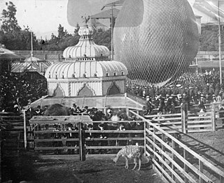
Woodward's Gardens, commonly referred to as The Gardens, was a combination amusement park, museum, art gallery, zoo, and aquarium operating from 1866 to 1891 in the Mission District of San Francisco, California. The Gardens covered two city blocks, bounded by Mission, Valencia, 13th, and 15th Streets in San Francisco. The site currently has a brick building at 1700 Mission Street, built after the 1906 San Francisco earthquake, which features a California Historical Site plaque, and the Crafty Fox Alehouse on the ground floor. The former Gardens site also features the current location of the San Francisco Armory, completed in 1914.
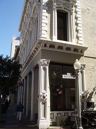
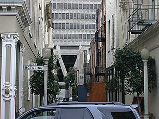
The Hotaling Building is a historic building in San Francisco, California. It is located at 451 Jackson Street in Jackson Square. It is a San Francisco Designated Landmark.

The Bank of Lucas, Turner & Company, also known as Sherman's Bank, is a historic building that was formerly a bank building, located at 800–804 Montgomery Street in Jackson Square in San Francisco, California.
Anson Parsons Hotaling or Houghtaling was an American merchant and real estate developer in San Francisco. He commonly went by the name A.P. Hotaling.

New Montgomery Street, formerly Montgomery Street South, begins at Market Street and terminates at Howard Street in the SOMA district of San Francisco, California.
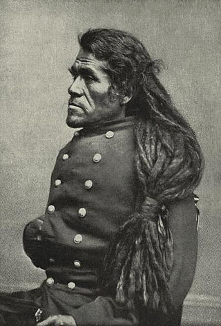
Irataba was a leader of the Mohave Nation, known as a mediator between the Mohave and the United States. He was born near the Colorado River in present-day Arizona. Irataba was a renowned orator and one of the first Mohave to speak English, a skill he used to develop relations with the United States.