Related Research Articles

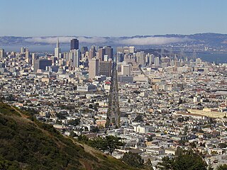
San Francisco, officially the City and County of San Francisco, is a commercial, financial, and cultural center within Northern California. With a population of 808,988 residents as of 2023, San Francisco is the fourth-most populous city in the U.S. state of California behind Los Angeles, San Diego, and San Jose, and the 17th most populous in the US. It covers a land area of 46.9 square miles at the upper end of the San Francisco Peninsula, making it the second-most densely populated major U.S. city behind New York City and the fifth-most densely populated U.S. county, behind four of New York City's boroughs. Among the 91 U.S. cities proper with over 250,000 residents, San Francisco is ranked first by per capita income and sixth by aggregate income as of 2023. San Francisco anchors the 13th most populous metropolitan statistical area in the United States, with almost 4.6 million residents in 2023. The larger San Jose–San Francisco–Oakland combined statistical area, the fifth-largest urban region in the U.S., had a 2023 estimated population of over 9 million.

Yerba Buena Island sits in San Francisco Bay within the borders of the City and County of San Francisco. The Yerba Buena Tunnel runs through its center and connects the western and eastern spans of the San Francisco–Oakland Bay Bridge, linking the city with Oakland, California. Treasure Island is connected by a causeway to Yerba Buena Island. According to the United States Census Bureau, Yerba Buena Island and Treasure Island together have a land area of 0.901 square miles (2.33 km2) with a total population of 2,500 as of the 2010 census.

South of Market (SoMa) is a neighborhood in San Francisco, California, situated just south of Market Street. It contains several sub-neighborhoods including South Beach, Yerba Buena, and Rincon Hill.

Californios are Hispanic Californians, especially those descended from Spanish and Mexican settlers of the 17th through 19th centuries before California was annexed by the United States. California's Spanish-speaking community has resided there since 1683 and is made up of varying Spanish and Mexican origins, including criollos, Mestizos, Indigenous Californian peoples, and small numbers of Mulatos. Alongside the Tejanos of Texas and Neomexicanos of New Mexico and Colorado, Californios are part of the larger Spanish-American/Mexican-American/Hispano community of the United States, which has inhabited the American Southwest and the West Coast since the 16th century. Some may also identify as Chicanos, a term that came about in the 1960s.

Yerba Buena Gardens is the name for two blocks of public parks located between Third and Fourth, Mission and Folsom Streets in the South of Market (SoMA) neighbourhood of San Francisco, California. The first block bordered by Mission and Howard Streets was opened on October 11, 1993. The second block, between Howard and Folsom Streets, was opened in 1998, with a dedication to Martin Luther King Jr. by Mayor Willie Brown. A pedestrian bridge over Howard Street connects the two blocks, sitting on top of part of the Moscone Center convention center. The Yerba Buena Gardens were planned and built as the final centerpiece of the Yerba Buena Redevelopment Area which includes the Yerba Buena Center for the Arts. Yerba Buena Gardens Conservancy operates the property on behalf of the City and County of San Francisco.

The Embarcadero is the eastern waterfront of Port of San Francisco and a major roadway in San Francisco, California. It was constructed on reclaimed land along a three mile long engineered seawall, from which piers extend into the bay. It derives its name from the Spanish verb embarcar, meaning "to embark"; embarcadero itself means "the place to embark." The Central Embarcadero Piers Historic District was added to the National Register of Historic Places on November 20, 2002.

The Financial District is a neighborhood in San Francisco, California, United States, that serves as its main central business district and had 372,829 jobs according to U.S. census tracts as of 2012-2016. It is home to the city's largest concentration of corporate headquarters, law firms, insurance companies, real estate firms, savings and loan banks, and other financial institutions. Multiple Fortune 500 companies headquartered in San Francisco have their offices in the Financial District, including Wells Fargo, Salesforce, and Gap.
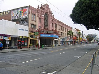
Mission Street is a north-south arterial thoroughfare in Daly City and San Francisco, California that runs from Daly City's southern border to San Francisco's northeast waterfront. The street and San Francisco's Mission District through which it runs were named for the Spanish Mission Dolores, several blocks away from the modern route. Only the southern half is historically part of El Camino Real, which connected the missions. Part of Mission Street in Daly City is signed as part of State Route 82.

William Anthony Richardson was an early California entrepreneur, influential in the development of Yerba Buena, the forerunner of the city of San Francisco.

Henry Mellus served as the eighth Mayor of Los Angeles from May 9, 1860, to December 26, 1860. He was a successful California businessman.
The history of the city of San Francisco, California, and its development as a center of maritime trade, were shaped by its location at the entrance to a large natural harbor. San Francisco is the name of both the city and the county; the two share the same boundaries. Only lightly settled by European-Americans at first, after becoming the base for the gold rush of 1849 the city quickly became the largest and most important population, commercial, naval, and financial center in the American West. San Francisco was devastated by a great earthquake and fire in 1906 but was quickly rebuilt. The San Francisco Federal Reserve Branch opened in 1914, and the city continued to develop as a major business city throughout the first half of the 20th century. Starting in the later half of the 1960s, San Francisco became the city most famous for the hippie movement. In recent decades, San Francisco has become an important center of finance and technology. The high demand for housing, driven by its proximity to Silicon Valley, and the limited availability has led to the city being one of America's most expensive places to live. San Francisco is currently ranked 16th on the Global Financial Centres Index.

The Port of San Francisco is a semi-independent organization that oversees the port facilities at San Francisco, California, United States. It is run by a five-member commission, appointed by the Mayor subject to confirmation by a majority of the Board of Supervisors. The Port is responsible for managing the larger waterfront area that extends from the anchorage of the Golden Gate Bridge, along the Marina district, all the way around the north and east shores of the city of San Francisco including Fisherman's Wharf and the Embarcadero, and southward to the city line just beyond Candlestick Point. In 1968, the State of California, via the California State Lands Commission for the State-operated San Francisco Port Authority, transferred its responsibilities for the Harbor of San Francisco waterfront to the City and County of San Francisco / San Francisco Harbor Commission through the Burton Act AB2649. All eligible State port authority employees had the option to become employees of the City and County of San Francisco to maintain consistent operation of the Port of San Francisco.

Jasper O'Farrell (1817–1875) was an Irish-American politician who served as the first surveyor for San Francisco. He designed the "grand promenade" that became today's Market Street. O'Farrell Street in San Francisco is named after him.
Market Street is a major thoroughfare in San Francisco, California. It begins at The Embarcadero in front of the Ferry Building at the northeastern edge of the city and runs southwest through downtown, passing the Civic Center and the Castro District, to the intersection with Portola Drive in the Twin Peaks neighborhood. Beyond this point, the roadway continues into the southwestern quadrant of San Francisco. Portola Drive extends south to the intersection of St. Francis Boulevard and Sloat Boulevard, where it continues as Junipero Serra Boulevard.

Yerba Buena was the name of an anchorage spot and later a town that grew into the city of San Francisco, California. The settlement, built in an area known earlier as El Paraje de Yerba Buena and named for an herb that grew abundantly there, was founded in 1834 and was located near the northeastern end of the San Francisco Peninsula, on the shores of Yerba Buena Cove. Yerba Buena was the first civilian pueblo in San Francisco, which had previously only had indigenous, missionary, and military settlements, and was originally intended as a trading post for ships visiting San Francisco Bay. The settlement was arranged in the Spanish style around a plaza that remains as the present day Portsmouth Square. The area that was the Yerba Buena settlement is now in the Financial District and Chinatown neighborhoods of San Francisco.

Grant Avenue in San Francisco, California, is one of the oldest streets in the city's Chinatown district. It runs in a north–south direction starting at Market Street in the heart of downtown and dead-ending past Francisco Street in the North Beach district. It resumes at North Point Street and stretches one block to The Embarcadero and the foot of Pier 39.
William Davis Merry Howard (1818–1856), known in Spanish as Don Guillermo Howard, was an American businessman, known as one of San Francisco's wealthiest men during the California Gold Rush.

Yerba Buena Cove was a cove on San Francisco Bay where the Mexican town of Yerba Buena was located. It lay between Clarks Point to the north and Rincon Point to the south. The beach of the cove was set as far back as what is now Montgomery Street between Clay and Washington Streets.

Rancho Las Camaritas was an Alta California land grant, a square of 300 Mexican varas on each side; varas being one pace, in this case 2.75 feet to José de Jesús Noé on January 21, 1840, by Governor Juan Bautista Alvarado. Millions of acres of California land was given at no charge to men between 1784 and 1846 by the Spanish (1784–1810) or Mexican governments (1819–1846) mostly for military service to raise cattle on. About 300 of the 800 Land grants were sizable varying from a few thousand to 1.5 million acres – see List of ranchos of California for the larger grants. Following the Mexican–American War, the land grants were challenged with most of them falling into American hands. Only one land grant has remained undeveloped. The ownership of Las Camaritas was disputed in court by the U.S. government from 1856 until 1882 due to conflicting documentation presented by its American owner Ferdinand Vassault after a string of sales initiated by Jose Noe sometime between 1842 and 1846.
William Sturgis Hinckley (1806-1846) was an American politician. He was the 9th Alcalde of San Francisco in California.
References
- ↑ Google Maps Driving Directions
- ↑ "Early San Francisco Street Names - 1846-1849". Archived from the original on 2007-08-07. Retrieved 2007-06-01.
| Numbered streets |  | |
|---|---|---|
| North–south streets |
| |
| East–west streets | ||
| Diagonal streets | ||
| Alleyways | ||