Hallidie Plaza

Last updated
Hallidie Plaza
Hallidie Plaza facing east, January 2020.JPG
View east in East Hallidie Plaza in 2020
Location map San Francisco Central.png
Red pog.svg
Location Map San Francisco Bay Area.png
Red pog.svg
USA California location map.svg
Red pog.svg
Location Union Square
Nearest city San Francisco
Coordinates 37°47′4″N122°24′29″W / 37.78444°N 122.40806°W / 37.78444; -122.40806 Coordinates: 37°47′4″N122°24′29″W / 37.78444°N 122.40806°W / 37.78444; -122.40806
Created1973
Designer
Public transit access Muni Metro/BART (Powell Street)

Hallidie Plaza is a public square located at the entrance to Powell Street Station (the third-busiest BART station as of 2015 [1] ) on Market Street in the Union Square area of downtown San Francisco, California, United States. Hallidie Plaza was designed jointly by Lawrence Halprin, John Carl Warnecke, and Mario Ciampi and opened in 1973. [2] In 1997, a perforated stainless steel-screened elevator was added to provide access to the plaza and station for disabled people.

Contents

Although Powell Street station is one of the busiest stations in the BART system, Hallidie Plaza is relatively underused and has been criticized for its isolation from Market.

Location and history

Escalator at the eastern tip of East Hallidie Plaza, with Flood Building in the background (2009) San Francisco - Flood Building from Hallidie Plaza.jpg
Escalator at the eastern tip of East Hallidie Plaza, with Flood Building in the background (2009)

Hallidie Plaza lies within the triangular block bounded by Market, Mason, and Eddy, north of Market; [2] the plaza is below grade, crossed by a bridge carrying Cyril Magnin/5th which divides the plaza into eastern and western parts. The western part receives relatively little use. [3] [4]

It is just south of the Flood Building, One Powell Street, and the cable car turntable at Powell and Market streets, [5] and lies across Market from the Westfield San Francisco Centre mall. Hallidie Plaza also includes the Powell Street mall, which is the one-block-long portion of Powell south of Eddy that has been closed to road traffic. [6] :4–62

Concept and design

After San Francisco Bay Area voters approved the creation of the Bay Area Rapid Transit District in 1962, the report What to Do About Market Street was published later that year. In it, Halprin and Associates, led by landscape architect Lawrence Halprin, called for pedestrian arcades to connect the planned transit station with parking garages, north or south of Market, in this retail district. [7] :31

Two potential sites were examined in the 1965 Market Street Design Report, written by the firms led by Mario J. Ciampi and John Carl Warnecke; one site was the triangular block eventually selected, bounded by Mason, Eddy, and Market; the other site was south of Market across from the Phelan Building. [8] By 1967, Ciampi and Warnecke had refined the design for the planned Powell Station Plaza; the 1967 site and design largely matched the eventual implementation of Hallidie Plaza, a sunken triangular plaza with escalators parallel to Market Street at the eastern and western ends. However, the 1967 plan called for more gradual amphitheater-style steps leading north to street level. [9]

The three architecture firms formed the Market Street Joint Venture Architects in 1968 to take on the Market Street Redevelopment Project in 1968, which also encompassed the design for two other large plazas along Market: United Nations Plaza at the neighboring Civic Center/​UN Plaza station and Embarcadero Plaza near the San Francisco Ferry Building. [6] :4–30

Hallidie Plaza opened in 1973, as a central element of a remodeling of Market Street spurred by BART reconstruction after the double-deck Market Street Subway tunnel was built using cut-and-cover construction. [4] It was named after Andrew Smith Hallidie, who developed the world's first cable car system in 1873. [4] [10]

Mr. Halprin has created, along Market Street, not only a cluster of places but a cluster of kinetic, human-scale experiences which make it architecture.

  William Marlin, The Architectural Forum (April 1973) [11]

As built, the plaza sits 20 feet (6.1 m) below street level, built with granite walls, terraced concrete planters and brick paving laid in a herringbone pattern, extending into a walkway underneath Cyril Magnin Street. [1] Mezzanine levels are provided on both the eastern and western portions of the plaza, and wood slat benches were originally installed on the lower and mezzanine levels of the plaza. In addition to the eastern and western escalators, the plaza can be accessed from street level via stairs in both portions, parallel to Cyril Magnin/5th. [6] :4–62 The plaza also contained a 1,880 sq ft (175 m2) visitor information center off the tunnel under Cyril Magnin/5th [12] from 1976 until it moved to Moscone Center at the end of 2018. [13]

Updates

East Hallidie Plaza and Powell Street entrance (2010); elevator and screen are prominent at right. Nearly Sunset (4375372566).jpg
East Hallidie Plaza and Powell Street entrance (2010); elevator and screen are prominent at right.

Construction of an elevator started in 1997; Michael Willis was the architect responsible for the perforated metal design. [14] The $510,000 elevator was approved after a lawsuit from disability rights activists charged that Hallidie Plaza was not accessible. The San Francisco Arts Commission was involved in the approval process, and took the opportunity to create a new public sculpture. [15]

During the administration of Mayor Willie Brown, more frequent police patrols initially displaced homeless residents from Civic Center Plaza to UN Plaza and Hallidie Plaza; [16] a committee of the San Francisco Board of Supervisors voted to bring the latter two under the city's Parks code which would allow stricter enforcement of laws criminalizing vagrancy; [17] [18] the full Board passed the measure in late January 1999. [19] John King noted that making the plazas more unwelcoming did not discourage the homeless from gathering and recommended instead "the city should strive for places that are vibrant and attract all walks of life." [20] Indeed, after Cable Car Coffee opened up a branch location in Hallidie Plaza in June 1998, the increase in retail activity depressed the number of homeless in the plaza. [21] The wood slat benches were removed in 1998, along with trees along the northeastern edge. [4]

Cable Car Coffee kiosk in East Hallidie Plaza (2009) San Francisco - Cable Car Coffee Hallidie Plaza.jpg
Cable Car Coffee kiosk in East Hallidie Plaza (2009)

In 2003, the mezzanine terrace was closed after reports of criminal activity; [22] the benches were removed and the terrace was reopened in 2005. [10]

In 2009, it was proposed to close the western part of the plaza; the area west of 5th/Cyril Magnin would be covered and a 480,000 US gal (1,800,000 L) cistern would be installed in the below-grade space, while the new deck would be used for cafe seating and public performances. The cistern would be used to hold groundwater pumped from Powell Street station; the station requires continuous pumping to prevent flooding from underground creeks. [3]

The city kicked off the Better Market Street project in 2012, aimed at improving the appeal of Market for the first time since the Market Street Redevelopment Plan was completed in the 1970s. [23] The Union Square Business Improvement District (USBID) released its Public Realm Design Manual in 2015, including a section entitled "Activating Hallidie Plaza" with suggestions to improve the site's usability and attract retail development. [24]

A sign with the names and distances to the nineteen sister cities of San Francisco was installed at Hallidie Plaza in late June 2018. [25] USBID has studied the possibility of adding flags of the sister cities to Hallidie Plaza and installing the large sculpture R-Evolution by Marco Cochrane to attract more activity. [26] [27]

Reception

San Francisco Chronicle urban design critic John King has described Hallidie Plaza as desolated, denounced its design as deeply flawed, and commented that "what was envisioned as a grand entrance instead is a void to avoid, a deep, angled space beloved by none but too pricey to fix." [1] King also said the plaza was "flawed from the start, products of a 1960s-era planning mentality that says spaces work best when they're kept apart from traffic and noise." [20] In contrast, architect Lajos Héder said the contrast created by the "technologically oriented BART environment [opening] directly onto the visual and social complexity of the San Francisco street scene ... has a genuine aesthetic value that transcends that of many more harmoniously integrated situations. It is a piece of powerful urban theater, by virtue of the impressions and lessons imparted by its contrasts." [28]

Clare Cooper Marcus faulted the lack of interesting features and the dramatic difference in elevation for its paucity of users: "At Hallidie Plaza in San Francisco, there is little to look at beyond a large expanse of brick paving, glaring granite walls (on a hot day it is like an oven), small trees that offer no shade, and colorless planters. ... It is little wonder that the seats at the intermediate and upper levels, where passersby and traffic on Market Street create some interest, are always more heavily used than are those in the sunken plaza areas." [29]

Hank Donat called the metal-screened elevator added in 1997 "San Francisco's Poop Chute", describing it as "a hideous and cold addition to the open plaza." [30] On April 30, 2018, BART started a pilot program to provide elevator attendants to discourage drug use and the elimination of human waste in the elevators at Powell Street and Civic Center/UN Plaza. [31] The pilot was expanded to the other two downtown BART stations in 2019. [32]

Related Research Articles

<span class="mw-page-title-main">Bay Area Rapid Transit</span> Railway system in San Francisco Bay Area, USA

Bay Area Rapid Transit (BART) is a rapid transit system serving the San Francisco Bay Area in California. BART serves 50 stations along six routes on 131 miles of rapid transit lines, including a 10-mile (16 km) spur line in eastern Contra Costa County which uses diesel multiple-unit trains and a 3.2-mile (5.1 km) automated guideway transit line to the Oakland International Airport. With an average of 136,200 weekday passengers as of the second quarter of 2022 and 26,026,800 annual passengers in 2021, BART is the fifth-busiest heavy rail rapid transit system in the United States.

<span class="mw-page-title-main">Union Square, San Francisco</span> Neighborhood of San Francisco in California, United States

Union Square is a 2.6-acre (1.1-hectare) public plaza bordered by Geary, Powell, Post and Stockton Streets in downtown San Francisco, California. "Union Square" also refers to the central shopping, hotel, and theater district that surrounds the plaza for several blocks. The area got its name because it was once used for Thomas Starr King rallies and support for the Union Army during the American Civil War, earning its designation as a California Historical Landmark.

<span class="mw-page-title-main">Embarcadero (San Francisco)</span> The eastern waterfront and roadway of the Port of San Francisco, along San Francisco Bay

The Embarcadero is the eastern waterfront and roadway of the Port of San Francisco, San Francisco, California, along San Francisco Bay. It was constructed on reclaimed land along a three mile long engineered seawall, from which piers extend into the bay. It derives its name from the Spanish verb embarcar, meaning "to embark"; embarcadero itself means "the place to embark". The Central Embarcadero Piers Historic District was added to the National Register of Historic Places on November 20, 2002.

<span class="mw-page-title-main">Embarcadero station</span> Combined rapid transit and light rail station in San Francisco

Embarcadero station is a combined BART and Muni Metro rapid transit station in the Market Street subway. Located under Market Street between Drumm Street and Beale Street near The Embarcadero, it serves the Financial District neighborhood and surrounding areas. The three-level station has a large fare mezzanine level, with separate platform levels for Muni Metro and BART below. Embarcadero opened in May 1976 – almost two years after service began through the Transbay Tube – as an infill station.

<span class="mw-page-title-main">Powell Street station</span> Rapid transit station in San Francisco, California, US

Powell Street station is a combined BART and Muni Metro rapid transit station in the Market Street subway. Located under Market Street between 4th Street and 5th Street, it serves the Financial District neighborhood and surrounding areas. The three-level station has a large fare mezzanine level, with separate platform levels for Muni Metro and BART below. The fare mezzanine also connects to the Union Square/Market Street station. The Powell-Mason and Powell-Hyde cable car lines turn around at Powell and Market adjacent to the station and Hallidie Plaza.

<span class="mw-page-title-main">Civic Center/UN Plaza station</span> Rapid transit station in San Francisco, California, US

Civic Center/UN Plaza station is a combined BART and Muni Metro rapid transit station in the Market Street Subway. Located under Market Street between 7th Street and 8th Street, it is named for the Civic Center neighborhood and the adjacent United Nations Plaza. The three-level station has a large fare mezzanine level, with separate platform levels for Muni Metro and BART below.

<span class="mw-page-title-main">Central Subway (San Francisco)</span> Underground light rail line under construction in San Francisco

The Central Subway is a Muni Metro light rail tunnel in San Francisco, California. It runs between Chinatown station in Chinatown and a portal in South of Market (SoMa), with intermediate stops at Union Square/Market Street station in Union Square and Yerba Buena/Moscone station in SoMa. A surface portion runs through SoMa to connect to the existing T Third Street line at 4th and King station.

<span class="mw-page-title-main">Market Street subway</span> BART-Muni Metro main line, San Francisco

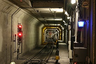
The Market Street subway is a two-level subway tunnel that carries Muni Metro and BART trains under Market Street in San Francisco, California. It runs under the length of Market Street between Embarcadero station and Castro station. The upper level is used by Muni Metro lines and the lower level is used by BART lines. BART does not run through the whole subway; it turns south and runs under Mission Street southwest of Civic Center/UN Plaza station. The northeastern end of the BART level is connected to the Transbay Tube. On the Muni Metro level, the southwestern end of the Market Street subway connects to the much-older Twin Peaks Tunnel, and the northeastern end connects to surface tracks along the Embarcadero.

<span class="mw-page-title-main">Lawrence Halprin</span>

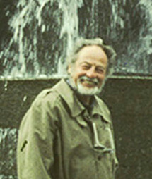
Lawrence Halprin was an American landscape architect, designer and teacher.

<span class="mw-page-title-main">12th Street Oakland City Center station</span> Rapid transit station in Oakland, California, US

12th Street/Oakland City Center station is an underground Bay Area Rapid Transit (BART) station located under Broadway between 12th Street and 14th Street in Downtown Oakland, adjacent to the Oakland City Center. It is the second-busiest BART station in both Oakland and the East Bay, and the 6th busiest BART station overall, with a daily ridership of approximately 13,900 in February 2020.

<span class="mw-page-title-main">19th Street Oakland station</span> Rapid transit station in San Francisco Bay Area

19th Street Oakland station is an underground Bay Area Rapid Transit (BART) station located under Broadway between 17th Street and 20th Street in the Uptown District of Oakland, California. It is a timed transfer point between northbound trains to Richmond and to Antioch. It is the busiest BART station in both Oakland and the East Bay, and the 5th busiest BART station overall, with a daily ridership of approximately 14,300 in February 2020.

Mario Joseph Ciampi was an American architect and urban planner best known for his modern design influence on public spaces and buildings in the San Francisco Bay Area.

<span class="mw-page-title-main">Market Street (San Francisco)</span> Thoroughfare in San Francisco, United States

Market Street is a major thoroughfare in San Francisco, California. It begins at The Embarcadero in front of the Ferry Building at the northeastern edge of the city and runs southwest through downtown, passing the Civic Center and the Castro District, to the intersection with Portola Drive in the Twin Peaks neighborhood. Beyond this point, the roadway continues into the southwestern quadrant of San Francisco. Portola Drive extends south to the intersection of St. Francis Boulevard and Sloat Boulevard, where it continues as Junipero Serra Boulevard.

<span class="mw-page-title-main">Embarcadero Plaza</span>

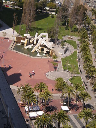
Embarcadero Plaza, previously known as Justin Herman Plaza from its opening in 1972 until 2017, is a 1.23-acre (0.50 ha) plaza near the intersection of Market and Embarcadero in San Francisco's Financial District, in the U.S. state of California. It is owned by Boston Properties, who acquired the neighboring Embarcadero Center office, hotel, and retail complex in 1998.

<span class="mw-page-title-main">Joseph Magnin</span> High-end department store

The Joseph Magnin Company was a high-end specialty department store founded in San Francisco, California, by Joseph Magnin, 4th son of Isaac Magnin founder of the I. Magnin department store. Joseph Magnin Co. and I. Magnin Co. were rivals.

<span class="mw-page-title-main">Cyril Magnin</span>

Cyril Isaac Magnin was an American businessman from San Francisco, California. He was the chief executive of the Joseph Magnin Co.

<span class="mw-page-title-main">Flood Building</span> Commercial offices, Retail space in San Francisco, California

The Flood Building is a 12-story highrise located at 870 Market Street on the corner of Powell Street in the downtown shopping district of San Francisco, California completed in 1904 and designed by Albert Pissis. Situated on Powell and Market streets, next to the Powell Street cable car turntable, Hallidie Plaza and the Powell Street BART Station entrance, it is one of the few structures that survived the 1906 San Francisco earthquake.

<i>Vaillancourt Fountain</i> Fountain in San Francisco, California, U.S.

Vaillancourt Fountain, sometimes called Quebec libre!, is a large fountain in Embarcadero Plaza in San Francisco, designed by the Québécois artist Armand Vaillancourt in 1971. It is about 40 feet (12 m) high and is constructed out of precast concrete square tubes. Long considered controversial because of its stark, modernist appearance, there have been several unsuccessful proposals to demolish the fountain over the years. It was the site of a free concert by U2 in 1987, when lead singer Bono spray painted graffiti on the fountain and was both praised and criticized for the action.

<span class="mw-page-title-main">United Nations Plaza (San Francisco)</span> Plaza in San Franciscos Civic Center

United Nations Plaza is a 2.6-acre (1.1 ha) plaza located on the former alignments of Fulton and Leavenworth Streets—in the block bounded by Market, Hyde, McAllister, and 7th Street—in the Civic Center of San Francisco, California. It is located 14 mi (0.40 km) east of City Hall and is connected to it by the Fulton Mall and Civic Center Plaza. Public transit access is provided by the BART and Muni Metro stops at the Civic Center/UN Plaza station, which has a station entrance within the plaza itself.

<span class="mw-page-title-main">31 Balboa</span> Trolleybus line operated by the San Francisco Municipal Railway

31 Balboa is a trolleybus line operated by the San Francisco Municipal Railway. It is one of several routes operating between the Financial District and the Richmond District.

References

  1. 1 2 3 King, John (November 11, 2015). "Sunken Hallidie Plaza was a deeply wrong design idea" . San Francisco Chronicle. Retrieved 11 April 2016.
  2. 1 2 King, John (August 16, 2014). "Spoilers: Eyesore buildings that taint their environment". San Francisco Chronicle. Retrieved 4 October 2018.
  3. 1 2 Gordon, Rachel (December 2, 2009). "Ideas for Hallidie Plaza include reservoir". San Francisco Chronicle. Retrieved 9 January 2020.
  4. 1 2 3 4 King, John (February 2, 2006). "Just start over with desolate Hallidie Plaza". San Francisco Chronicle. Retrieved 9 January 2020.
  5. King, John (March 10, 2005). "Attention shoppers -- This building is a beautifully restored piece of history". San Francisco Chronicle. Retrieved 9 January 2020.
  6. 1 2 3 ICF (November 2016). Cultural Landscape Evaluation, Better Market Street Project (PDF) (Report). Final. San Francisco Department of Public Works. Retrieved 8 January 2020.
  7. Halprin, Lawrence; Carter, Donald Ray; Rockrise, George T. (1962). "The Look of Market Street". What to Do About Market Street: A prospectus for a development program prepared for the Market Street Development Project, an associate of SPUR: The San Francisco Planning and Urban Renewal Association (Report). Livingston and Blayney, City and Regional Planners. Retrieved 15 October 2018.
  8. Mario J. Ciampi & Associates, Architects & Urban Consultants; John Carl Warnecke & Associates, Architects & Planning Consultants (23 June 1965). Market Street design report number 2 – Subway Entrance Plazas (Report). City and County of San Francisco. Retrieved 7 January 2020.
  9. Warnecke, John Carl; Ciampi, Mario (1967). Market Street design plan: summary report (Report). Department of City Planning, San Francisco. Retrieved 5 October 2018.
  10. 1 2 Pullen, Suzanne (July 14, 2005). "CHRONICLEWATCH Results / Working for a better Bay Area". San Francisco Chronicle. Retrieved 9 January 2020.
  11. Marlin, William (April 1973). "San Francisco: The Streets of Camelot" (PDF). Architectural Forum. Vol. 138, no. 3. Billboard. p. 34. Retrieved 9 January 2020.
  12. "Visitor Information Center FAQ". San Francisco Travel. Retrieved 2016-04-11.
  13. Li, Roland (July 20, 2018). "San Francisco's visitor center moving from Powell area to Moscone Center". San Francisco Chronicle. Retrieved 9 January 2020.
  14. Adams, Gerald D. (April 12, 1997). "Elevator will go to Hallidie Plaza". San Francisco Examiner. Retrieved 9 January 2020.
  15. Matier, Philip; Ross, Andrew; Marinucci, Carla (October 13, 1997). "MATIER & ROSS -- That's Not Just an Elevator, It's Public Sculpture, S.F. Style". San Francisco Chronicle. Retrieved 9 January 2020.
  16. Gordon, Rachel (January 12, 1999). "U.N. Hallidie plazas next for S.F. homeless sweeps". San Francisco Examiner. Retrieved 9 January 2020.
  17. Epstein, Edward (January 21, 1999). "Crackdown on Homeless Extended to Hallidie, U.N. Plazas / Proposal would put areas under city's park code". San Francisco Chronicle. Retrieved 9 January 2020.
  18. Gordon, Rachel (January 21, 1999). "New crackdown on city's homeless". San Francisco Examiner. Retrieved 9 January 2020.
  19. Epstein, Edward (January 26, 1999). "More Ground Pulled From Under S.F. Homeless / Union Square spruce-up approved, crackdown in U.N., Hallidie plazas". San Francisco Chronicle. Retrieved 9 January 2020.
  20. 1 2 King, John (March 10, 2002). "Common ground / By shooing vagrants, S.F. plazas have gone from bad to worse -- now planners plead for city to put out the welcome mat". San Francisco Chronicle. Retrieved 9 January 2020.
  21. Epstein, Edward (September 8, 1998). "Proposal to Roust Homeless From Downtown Plazas / Foe says S.F. supervisor's suggestion is re-election ploy". San Francisco Chronicle. Retrieved 9 January 2020.
  22. Pullen, Suzanne (October 5, 2003). "ChronicleWatch: Working for a better Bay Area". San Francisco Chronicle. Retrieved 9 January 2020.
  23. Wildermuth, John (September 16, 2012). "SF Market Street up for a face-lift". San Francisco Chronicle. Retrieved 9 January 2020.
  24. RHAA (April 17, 2015). "4.02 Activating Hallidie Plaza". Public Realm Design Manual (PDF) (Report). Union Square Business Improvement District. Retrieved 9 January 2020.
  25. Costley, Drew (July 2, 2018). "San Francisco's 19 sister cities get new sign in Hallidie Plaza. Do you know them all?". SFGate. Retrieved 9 January 2020.
  26. "Hallidie Plaza". Union Square Foundation. Retrieved 10 January 2020.
  27. Union Square Business Improvement District Executive Committee Meeting (PDF) (Report). Union Square Business Improvement District. October 24, 2019. Retrieved 10 January 2020.
  28. Héder, Lajos; Shoshkes, Ellen (November 1980). "Facility Design: Rapid Transit | Case Study 2.5b – BART, A High Technology System". Aesthetics in Transportation: Guidelies for Incorporating Design, Art and Architecture Into Transportation Facilities (Report). Washington DC: U.S. Department of Transportation. pp. 131–132. Retrieved 10 January 2020.
  29. Marcus, Clare Cooper; Francis, Carolyn; Russell, Robert (1998). "1. Urban Plazas". In Marcus, Clare Cooper; Francis, Carolyn (eds.). People Places: Design Guidelines for Urban Open Space (Second ed.). New York City: John Wiley & Sons. pp. 46–47. ISBN   0-471-28833-0 . Retrieved 10 January 2020.
  30. Donat, Hank (2005). "Wall of Infamy". Mister SF. Retrieved 9 January 2020.
  31. Rodriguez, Joe Fitzgerald (April 30, 2018). "BART and Muni elevator attendants shoo away urinators, drug users". San Francisco Examiner. Retrieved 10 January 2020.
  32. McFarland, Cody (November 6, 2019). "Attendant program keeping BART elevators safe, clean expands to two more downtown stations". San Francisco Examiner. Retrieved 10 January 2020.