Claremont Tunnel

Last updated
Claremont Tunnel
Location map Oakland.png
Red pog.svg
Location Map San Francisco Bay Area.png
Red pog.svg
Overview
Coordinates 37°52′17″N122°13′13″W / 37.8714°N 122.2202°W / 37.8714; -122.2202
StatusActive
Operation
Opened1929 (1929)
Owner East Bay Municipal Utility District (EBMUD)
Characterwater tunnel
Technical
Length18,065 feet (5,506 m) long
Tunnel clearance 9 feet (2.7 m) square

Claremont Tunnel, also known as the Claremont Water Tunnel is a utility tunnel in Alameda County, in the U.S. state of California [1] near the historic Claremont Hotel. The tunnel crosses the Hayward Fault and carries water for 800,000 EBMUD customers.

Contents

History

The Claremont Tunnel was built in 1929. [2]

After the Loma Prieta earthquake in 1989, EBMUD began studying the potential effect of a large seismic event along the Hayward Fault. In the worst-case scenario, slip along the fault would sever the tunnel, disrupting the water supply to approximately 50 to 70% (800,000) of EBMUD's customers for up to six months. [3] [4] [5] In response, EBMUD approved a $189 million Seismic Improvement Plan in 1994, [4] which included seismic upgrades to the Claremont Tunnel. [5] Seismic upgrades began in 2004 and completed in 2007. [2]

Design

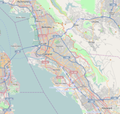
The original tunnel connects the EBMUD treatment plant in Orinda with the distribution system west of the Oakland Hills. [6] It featured a bore 9 feet (2.7 m) square with a mostly unreinforced concrete lining 1-foot (0.30 m) thick. [7] At peak capacity, the tunnel can deliver 175,000,000 US gallons per day (460,000 L/min). [6]

The tunnel crosses the Hayward Fault at a nearly perpendicular angle 850 feet (260 m) from its western portal, and creep along the fault resulted in an offset of 13 inches (330 mm) by 2008. [6] The maximum credible earthquake (magnitude 7.0) predicted in studies would cause an offset of 7.5 feet (2.3 m). [3] [8] For the seismic upgrade, a reinforced bypass tunnel was constructed across the Hayward Fault starting in 2004. [2] The seismic upgrade also injected grout to improve contact between the 1929 concrete tunnel and the surrounding earth. [9] For the bypass, first a 480-foot (150 m) access tunnel was bored into the fault zone. [10] Next, the space for the 1,570-foot (480 m) long bypass tunnel [7] was excavated using the New Austrian tunnelling method. [3]

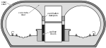
A bypass tunnel was used to avoid disrupting service through the main tunnel and to minimize cost and time. [7] The bypass tunnel is 11 feet (3.4 m) in diameter, except for a reinforced section crossing the fault, where it takes on an oval cross-section 17 feet (5.2 m) wide for a length of 108 feet (33 m). In the reinforced section, the concrete liner of the tunnel is 2 feet (0.61 m) thick, instead of the 1-foot (0.30 m) thickness elsewhere in the bypass tunnel. [10] The reinforced section was excavated by first boring two drifts to either side of the planned section. The space between the two drifts was excavated, and then the drifts were filled with concrete so that if the reinforced section breaks, the water will not wash out the dirt surrounding the tunnel. [7]

In the reinforced section, the reinforcement is weakened every 11 feet (3.4 m) along its length to allow the reinforced section to shear predictably in the event of a slip along the fault. The reinforced section is fitted with a steel carrier pipe 3 inches (76 mm) thick with a 6 feet (1.8 m) inner diameter, capable of delivering 130,000,000 US gallons per day (340,000 L/min). Up to an 8.5 feet (2.6 m) offset can be accommodated without breaking the pipe or losing water delivery. [7] [10] The bypass tunnel was designed by Jacobs Associates for EBMUD, and cost $38 million. It went into service on May 30, 2007. [7]

Related Research Articles

<span class="mw-page-title-main">Tunnel</span> Underground passage made for traffic

A tunnel is an underground passageway, dug through surrounding soil, earth or rock, and enclosed except for the entrance and exit, commonly at each end. A pipeline is not a tunnel, though some recent tunnels have used immersed tube construction techniques rather than traditional tunnel boring methods.

<span class="mw-page-title-main">Great Hanshin earthquake</span> Earthquake in Japan on January 17, 1995

An earthquake occurred on January 17, 1995, at 05:46:53 JST in the southern part of Hyōgo Prefecture, Japan, including the region known as Hanshin. It measured 6.9 on the moment magnitude scale and had a maximum intensity of 7 on the JMA Seismic Intensity Scale. The tremors lasted for approximately 20 seconds. The focus of the earthquake was located 17 km beneath its epicenter, on the northern end of Awaji Island, 20 km away from the center of the city of Kobe.

<span class="mw-page-title-main">1971 San Fernando earthquake</span> Earthquake in California

The 1971 San Fernando earthquake occurred in the early morning of February 9 in the foothills of the San Gabriel Mountains in southern California. The unanticipated thrust earthquake had a magnitude of 6.5 on the Ms scale and 6.6 on the Mw scale, and a maximum Mercalli intensity of XI (Extreme). The event was one in a series that affected Los Angeles county in the late 20th century. Damage was locally severe in the northern San Fernando Valley and surface faulting was extensive to the south of the epicenter in the mountains, as well as urban settings along city streets and neighborhoods. Uplift and other effects affected private homes and businesses.

<span class="mw-page-title-main">California State Route 13</span> State highway in Alameda County, California, United States

State Route 13 is a state highway in the U.S. state of California. It runs entirely in Alameda County, connecting Interstate 580 in Oakland to Interstate 80/Interstate 580 in Berkeley.

<span class="mw-page-title-main">East Bay Municipal Utility District</span>

East Bay Municipal Utility District (EBMUD), colloquially referred to as "East Bay Mud", is a public utility district which provides water and sewage treatment services for an area of approximately 331 square miles (860 km2) in the eastern side of the San Francisco Bay. As of 2018, EBMUD provides drinking water for approximately 1.4 million people in portions of Alameda County and Contra Costa County in California, including the cities of Richmond, El Cerrito, Hercules, San Pablo, Pinole, Lafayette, Moraga, Orinda, Danville, Oakland, Piedmont, Emeryville, Berkeley, Albany, Alameda, San Leandro, neighboring unincorporated regions, and portions of cities such as Hayward and San Ramon. Sewage treatment services are provided for 685,000 people in an 88-square-mile area (as of 2018). EBMUD currently has an average annual growth rate of 0.8% and is projected to serve 1.6 million people by 2030. Headquartered in Oakland, EBMUD owns and maintains 2 water storage reservoirs on the Mokelumne River, 5 terminal reservoirs, 91 miles (146 km) of water transmission aqueducts, 4,100 miles (6,600 km) of water mains, 6 water treatment plants (WTPs), 29 miles (47 km) of wastewater interceptor sewer lines and a regional wastewater treatment facility (WWTF) rated at a maximum treatment capacity of 320 MGD.

<span class="mw-page-title-main">Richmond–San Rafael Bridge</span> Bridge crossing the San Francisco Bay

The Richmond–San Rafael Bridge is the northernmost of the east–west crossings of California's San Francisco Bay, carrying Interstate 580 from Richmond on the east to San Rafael on the west. It opened in 1956, replacing ferry service by the Richmond–San Rafael Ferry Company, and was officially renamed in 1981 to honor California State Senator John F. McCarthy, who championed the bridge's creation.

<span class="mw-page-title-main">Hayward Fault Zone</span> Geological fault in the San Francisco Bay Area

The Hayward Fault Zone is a right-lateral strike-slip geologic fault zone capable of generating destructive earthquakes. The fault was first named in the Lawson Report of the 1906 San Francisco Earthquake in recognition of its involvement in the earthquake of 1868. This fault is about 119 km (74 mi) long, situated mainly along the western base of the hills on the east side of San Francisco Bay. It runs through densely populated areas, including Richmond, El Cerrito, Berkeley, Oakland, San Leandro, Castro Valley, Hayward, Union City, Fremont, and San Jose.

<span class="mw-page-title-main">Seismic retrofit</span> Modification of existing structures to make them more resistant to seismic activity

Seismic retrofitting is the modification of existing structures to make them more resistant to seismic activity, ground motion, or soil failure due to earthquakes. With better understanding of seismic demand on structures and with our recent experiences with large earthquakes near urban centers, the need of seismic retrofitting is well acknowledged. Prior to the introduction of modern seismic codes in the late 1960s for developed countries and late 1970s for many other parts of the world, many structures were designed without adequate detailing and reinforcement for seismic protection. In view of the imminent problem, various research work has been carried out. State-of-the-art technical guidelines for seismic assessment, retrofit and rehabilitation have been published around the world – such as the ASCE-SEI 41 and the New Zealand Society for Earthquake Engineering (NZSEE)'s guidelines. These codes must be regularly updated; the 1994 Northridge earthquake brought to light the brittleness of welded steel frames, for example.

<span class="mw-page-title-main">Transbay Tube</span> Underwater rail tunnel under San Francisco Bay

The Transbay Tube is an underwater rail tunnel that carries Bay Area Rapid Transit's four transbay lines under San Francisco Bay between the cities of San Francisco and Oakland in California. The tube is 3.6 miles (5.8 km) long, and attaches to twin bored tunnels. The section of rail between the nearest stations totals 6 miles (10 km) in length. The tube has a maximum depth of 135 feet (41 m) below sea level.

<span class="mw-page-title-main">Eastern span replacement of the San Francisco–Oakland Bay Bridge</span> Seismic stabilization megaproject in California (2002–2013)

The eastern span replacement of the San Francisco–Oakland Bay Bridge was a construction project to replace a seismically unsound portion of the Bay Bridge with a new self-anchored suspension bridge (SAS) and a pair of viaducts. The bridge is in the U.S. state of California and crosses the San Francisco Bay between Yerba Buena Island and Oakland. The span replacement took place between 2002 and 2013, and is the most expensive public works project in California history, with a final price tag of $6.5 billion, a 2,500% increase from the original estimate of $250 million, which was an initial estimate for a seismic retrofit of the span, not the full span replacement ultimately completed. Originally scheduled to open in 2007, several problems delayed the opening until September 2, 2013. With a width of 258.33 ft (78.74 m), comprising 10 general-purpose lanes, it is the world's widest bridge according to Guinness World Records.

<span class="mw-page-title-main">Lake Temescal</span> Lake in California, USA

Lake Temescal is a small reservoir in the Oakland hills, in northeastern Oakland, California. It is the centerpiece of Temescal Regional Recreation Area, also known as Temescal Regional Park. It is a part of the East Bay Regional Park District.

<span class="mw-page-title-main">Berkeley Hills</span> Region of the Pacific Coast Ranges

The Berkeley Hills are a range of the Pacific Coast Ranges that overlook the northeast side of the valley that encompasses San Francisco Bay. They were previously called the "Contra Costa Range/Hills", but with the establishment of Berkeley and the University of California, the current usage was applied by geographers and gazetteers.

<span class="mw-page-title-main">Contra Dam</span> Dam in Ticino, Switzerland

The Contra Dam, commonly known as the Verzasca Dam and the Locarno Dam, is an arch dam on the Verzasca River in the Val Verzasca of Ticino, Switzerland. The dam creates Lago di Vogorno 2 km (1.2 mi) upstream of Lake Maggiore and supports the 105 MW Verzasca hydroelectric power station. It was constructed between 1961 and 1965 and starting shortly after its reservoir was filled, a series of earthquakes related to its water load occurred until 1971. The dam is owned and operated by Verzasca SA and is the fourth tallest in Switzerland.

The earthquake bomb, or seismic bomb, was a concept that was invented by the British aeronautical engineer Barnes Wallis early in World War II and subsequently developed and used during the war against strategic targets in Europe. A seismic bomb differs somewhat in concept from a traditional bomb, which usually explodes at or near the surface and destroys its target directly by explosive force; in contrast, a seismic bomb is dropped from high altitude to attain very high speed as it falls and upon impact, penetrates and explodes deep underground, causing massive caverns or craters known as camouflets, as well as intense shockwaves. In this way, the seismic bomb can affect targets that are too massive to be affected by a conventional bomb, as well as damage or destroy difficult targets such as bridges and viaducts.

<span class="mw-page-title-main">San Pablo Reservoir</span> Reservoir in California, United States

The San Pablo Reservoir is an open cut terminal water storage reservoir owned and operated by the East Bay Municipal Utility District (EBMUD). It is located in the valley of San Pablo Creek, north of Orinda, California, United States, and south of El Sobrante and Richmond, east of the Berkeley Hills between San Pablo Ridge and Sobrante Ridge.

<span class="mw-page-title-main">Cull Canyon Regional Recreation Area</span> Regional park in Alameda County, California, US

Cull Canyon Regional Recreation Area (CCRRA) is a regional park located in Castro Valley, Alameda County, California. It is part of the East Bay Regional Park District (EBRPD) system.

<span class="mw-page-title-main">Auburn Dam</span> Dam in Near Auburn, California

Auburn Dam was a proposed concrete arch dam on the North Fork of the American River east of the town of Auburn, California, in the United States, on the border of Placer and El Dorado Counties. Slated to be completed in the 1970s by the U.S. Bureau of Reclamation, it would have been the tallest concrete dam in California and one of the tallest in the United States, at a height of 680 feet (210 m) and storing 2,300,000 acre-feet (2.8 km3) of water. Straddling a gorge downstream of the confluence of the North and Middle Forks of the American River and upstream of Folsom Lake, it would have regulated water flow and provided flood control in the American River basin as part of Reclamation's immense Central Valley Project.

<span class="mw-page-title-main">Mokelumne Aqueduct</span> Bridge

The Mokelumne Aqueduct is a 95-mile (153 km) water conveyance system in central California, United States. The aqueduct is supplied by the Mokelumne River and provides water to 35 municipalities in the East Bay in the San Francisco Bay Area. The aqueduct and the associated dams, pipelines, treatment plants and hydroelectric system are owned and operated by the East Bay Municipal Utility District (EBMUD) and provide over 90 percent of the water used by the agency.

<span class="mw-page-title-main">San Mateo–Hayward Bridge</span> Road bridge across San Francisco Bay in California, United States

The San Mateo–Hayward Bridge is a bridge crossing the American state of California's San Francisco Bay, linking the San Francisco Peninsula with the East Bay. The bridge's western end is in Foster City, a suburb on the eastern edge of San Mateo. The eastern end of the bridge is in Hayward. It is the longest fixed-link bridge in California and the 25th longest in the world by length. The bridge is owned by the state of California, and is maintained by California Department of Transportation (Caltrans), the state highway agency. Further oversight is provided by the Bay Area Toll Authority (BATA).

<span class="mw-page-title-main">Matahina Power Station</span> Dam in Bay of Plenty

The Matahina power station is a hydroelectric power facility in Bay of Plenty in New Zealand located in the Bay of Plenty on the Rangitaiki River downstream of the Aniwhenua Power Station. The river was dammed to form Lake Matahina from which water is drawn and diverted through the power station before being discharged back into the river. The Matahina dam is the largest earth embankment dam in the North Island of New Zealand.

References

  1. U.S. Geological Survey Geographic Names Information System: Claremont Tunnel
  2. 1 2 3 "Claremont Tunnel Seismic Upgrade". Atkinson Construction. Retrieved 21 December 2017.
  3. 1 2 3 "Claremont Tunnel". EPC Consultants. Retrieved 21 December 2017.
  4. 1 2 Siegel, Max (16 May 2011). "After a quake, what will happen to the Bay Area's water supply?". Oakland North. Retrieved 21 December 2017.
  5. 1 2 "Case Study: Seismic Improvement Program, East Bay Municipal Utility District" (PDF). Earthquake Engineering Research Institute: Mitigation Center. Retrieved 21 December 2017.
  6. 1 2 3 "Of Tunnels and Earthquakes: Part I". Berkeley Seismology Lab. 15 December 2008. Retrieved 21 December 2017.
  7. 1 2 3 4 5 6 rockman (24 June 2008). "The Claremont Tunnel – Designed to Survive Fault Rupture on the Hayward Fault". GeoPrac. Retrieved 21 December 2017.
  8. Caulfield, R. John; Kieffer, D. Scott; Tsztoo, David F.; Cain, Bill (January 2005). "89". Seismic Design Measures for the Retrofit of the Claremont Tunnel (PDF). Rapid Excavation and Tunneling Conference. Society for Mining, Metallurgy & Exploration. pp. 1128–1138. ISBN   0873352432. Archived from the original (PDF) on 15 October 2006. Retrieved 21 December 2017. ResearchGate link
  9. 2004 2005 Progress Report: Seismic Improvement Program (PDF) (Report). EBMUD. 2005. Archived from the original (PDF) on 24 September 2008. Retrieved 21 December 2017.
  10. 1 2 3 "Of Tunnels and Earthquakes: Part II". Berkeley Seismology Lab. 19 December 2008. Retrieved 21 December 2017.

Wilson, S.H., R.J. Caulfield, and D.F. Tsztoo. 2006. Engineering geology of a tunnel through the Hayward Fault Zone. In Honor of Professor Edward L. Doheny, PG. Geological Society of America Abstracts with Programs 38(7).

Wilson, S.H., D.F. Tsztoo, C.R. Handford, and K. Rossi 2007. Excavation and support of a water tunnel through the Hayward Fault Zone Rapid Excavation and Tunneling Conference Proceedings, Toronto, Ontario, Canada.

Wilson, S.H., D.F. Tsztoo, C.R. Handford, and K. Rossi. 2008. Safeguarding a lifeline Civil Engineering Magazine 78(5).

Papers