Alto tunnel

Last updated
Alto Tunnel
Alto Tunnel North Portal.jpg
The north portal of the tunnel in 2023
Overview
LineCorte Madera-Sausalito Line
LocationMarin County, California
Coordinates
StatusUnsafe, sealed
System Northwestern Pacific Railroad
CrossesCamino Alto
Start Corte Madera, California (north)
End Mill Valley, California (south)
Operation
OpenedApril 1884
ClosedNovember 1971
TrafficRailway
CharacterPassenger and freight
Technical
Length2,173 feet (662 m)
No. of tracks 1 single-track
Track gauge Narrow-gauge
Tunnel clearance 20 feet (6.1 m)
Width16 feet (4.9 m)

The Alto tunnel is a disused railway tunnel in Marin County, California that connects the towns of Mill Valley and Corte Madera. It was built in 1884 by the Northwestern Pacific Railroad as part of the Corte Madera-Sausalito line. The tunnel is narrow-gauge and single tracked, with a length of 2,173 feet (662 m) and a cross section 16 feet (4.9 m) wide by 20 feet (6.1 m) high. [1] [2] [3]

Contents

History

Operation

The Alto tunnel was built in 1884 to connect Mill Valley and Corte Madera as part of the Corte Madera-Sausalito line, which connected the docks in Sausalito with the cities to the north. The tunnel began operation in April of the same year. In 1929, the Southern Pacific Railroad became the sole owner of the tunnel. Passenger service through the tunnel ceased in 1940 with the decline of the Northwestern Pacific interurban system, although freight traffic still continued along the line. In 1971, rail traffic in the tunnel ceased altogether with the final train being run through on November 23, 1971 and the tunnel was shut down. [4] [1]

Closure

Following the closure, two heavy bulkheads were installed at the tunnel portals to prevent entry. One year later, the Golden Gate Transit District attempted to purchase the entire line, including the Alto tunnel for use as a commuter rail line. The purchase was shut down due to local worries, specifically in relation to noise and safety. Then in the late 1970s, the County of Marin purchased an additional part of the right of way from Southern Pacific, but left the Alto Tunnel in their hands.

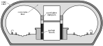
In 1975, a 124 feet (38 m) long concrete plug was installed in the tunnel to address stability concerns. Southern Pacific officially sealed the tunnel not in 1979. Two years later, part of the tunnel collapsed, destroying a house and multiple underground utilities in the process. As a result, 400 feet (120 m) of the tunnel was filled with concrete and gravel to further improve stability and safety. [1]

Viability as a bike path

In 1994, the Marin County Department of Parks and Open Space made the decision to hire Brady and Associates to assess the tunnel's viability as a bike path. Multiple feasibility studies were carried out, notably in 2001, 2008, and 2010, the most recent of which produced a rehabilitation cost estimate based on the project costs of the Cal Park Hill Tunnel rehabilitation. In addition to providing cost estimates, the 2010 study estimated tunnel use figures. The study concluded that the tunnel would have 850,000-1,850,000 annual users. [5]

The rehabilitation and permanent closure cost estimates were refined in 2016-2017. The 2016-2017 study, which totaled a cost of $646,000 despite an estimated cost of $558,620, quoted a base case cost of 46.8 million dollars, with a best to worst case range of 42.1-50.5 million dollars for rehabilitation. [1] [6] The total estimated product cost of filling and closure was estimated at 8.5 million dollars, with an estimated annual maintenance cost of 308,000 dollars. [7] [8] [9]

Multiple organizations, namely the Friends of Alto Tunnel organization have been petitioning for the tunnel's reopening. [10]

Structure

The original tunnel supports were made of redwood timber, specifically 10in by 14in sets in a 7-segment configuration spaced 1–5 ft apart. As their condition got worse, they were replaced by 5-segment sets of similar dimensions. The tunnel has a concrete portal barrel with a length of 30.9 feet (9.4 m) located at the north portal.

The tunnel was dug through rock of the Franciscan group, consisting mainly of sandstone, conglomerates, and shales.

As it stands, the southern part of the tunnel is in a significantly worse state than the northern part. The geology in the southern half is generally weaker, stronger supports were needed during initial construction of the tunnel, and the southern half has been the location of many collapses and other accidents. The 2017 investigation revealed that most of the southern half of the tunnel was flooded with rubble. [1] [3]

Related Research Articles

<span class="mw-page-title-main">Marin County, California</span> County in California, United States

Marin County is located in the northwestern part of the San Francisco Bay Area of the U.S. state of California. As of the 2020 census, the population was 262,231. Its county seat and largest city is San Rafael. Marin County is across the Golden Gate Bridge from San Francisco, and is included in the San Francisco–Oakland–Berkeley, CA Metropolitan Statistical Area.

<span class="mw-page-title-main">Mill Valley, California</span> City in California, United States

Mill Valley is a city in Marin County, California, United States, located about 14 miles (23 km) north of San Francisco via the Golden Gate Bridge and 52 miles (84 km) from Napa Valley. The population was 14,231 at the 2020 census.

<span class="mw-page-title-main">Strawberry, Marin County, California</span> Census-designated place in California, United States

Strawberry is a census-designated place (CDP) and an unincorporated district of Marin County, California, United States. It shares a ZIP code (94941) with Mill Valley and falls within its school districts; however, it is considered within the sphere of influence of the town of Tiburon. It is largely separated from Mill Valley by U.S. Route 101. Its population was 5,447 at the 2020 census.

<span class="mw-page-title-main">Richmond–San Rafael Bridge</span> Bridge crossing the San Francisco Bay

The Richmond–San Rafael Bridge is the northernmost of the east–west crossings of California's San Francisco Bay, carrying Interstate 580 from Richmond on the east to San Rafael on the west. It opened in 1956, replacing ferry service by the Richmond–San Rafael Ferry Company, and was officially renamed in 1981 to honor California State Senator John F. McCarthy, who championed the bridge's creation.

<span class="mw-page-title-main">Northwestern Pacific Railroad</span> Regional railroad in California, US

The Northwestern Pacific Railroad is a 271-mile (436 km) mainline railroad from the ferry connections in Sausalito, California north to Eureka with a connection to the national railroad system at Schellville. The railroad has gone through a history of different ownership and operators but has maintained a generic name of reference as The Northwestern Pacific Railroad, despite no longer being officially named that. Currently, only a 62-mile (100 km) stretch of mainline from Larkspur to the Sonoma County Airport in Windsor and east to Schellville on the “south end” is operated by Sonoma–Marin Area Rail Transit (SMART), which operates both commuter and freight trains with plans for future extension north to Cloverdale. The “north end” from Willits to Eureka is currently out of service, but saved by 2018 legislation to be converted into the Great Redwood Trail.

<span class="mw-page-title-main">Richardson Bay</span> Arm of San Francisco Bay

Richardson Bay is a shallow, ecologically rich arm of San Francisco Bay, managed under a Joint Powers Agency of four northern California cities. The 911-acre (369 ha) Richardson Bay Sanctuary was acquired in the early 1960s by the National Audubon Society. The bay was named for William A. Richardson, early 19th century sea captain and builder in San Francisco. It contains both Strawberry Spit and Aramburu Island.

<span class="mw-page-title-main">North Pacific Coast Railroad</span> Railroad in California

The North Pacific Coast Railroad (NPC) was a common carrier 3 ft (914 mm) narrow-gauge steam railroad begun in 1874 and sold in 1902 to new owners who renamed it the North Shore Railroad (California) (NSR) and which rebuilt the southern section into a standard-gauge electric railway.

California Park is an unincorporated community in Marin County, California, United States, and a suburb of San Rafael. It lies north of San Quentin State Prison. Marin Sanitary Service is the largest tenant in the area.

<span class="mw-page-title-main">Tamalpais Union High School District</span> School district in California

The Tamalpais Union High School District or TUHSD provides high school education to students residing in ten elementary districts in central and southern Marin County, California and parts of West Marin. The headquarters are on the property of Redwood High School in Larkspur, California.

<span class="mw-page-title-main">Arroyo Corte Madera del Presidio</span> River in California, United States

Arroyo Corte Madera del Presidio is a 4.1-mile-long (6.6 km) year-round stream in southern Marin County, California, United States. This watercourse is also known as Corte Madera Creek, although the actual stream of that name flows into San Francisco Bay further north at Point San Quentin. This watercourse has a catchment basin of about 8 square miles (21 km2) and drains the south-eastern slopes of Mount Tamalpais and much of the area in and around the town of Mill Valley; this stream discharges to Richardson Bay.

<span class="mw-page-title-main">Palo Alto station</span> Train station in Palo Alto, California, U.S.

Palo Alto station is an intermodal transit center in Palo Alto, California. It is served by Caltrain regional rail service, SamTrans and Santa Clara VTA local bus service, Dumbarton Express regional bus service, the Stanford University Marguerite Shuttle, and several local shuttle services. Palo Alto is the second-busiest Caltrain station after San Francisco, averaging 7,764 weekday boardings by a 2018 count. The Caltrain station has two side platforms serving the two tracks of the Peninsula Subdivision and a nearby bus transfer plaza.

Bothin Marsh is a 106 acres (43 ha) wetland in Marin County, California. Parts of the wetlands are in the Bothin Marsh Open Space Preserve, a regional park.

The Marin County Board of Supervisors is the governing body for the unincorporated areas of Marin County, California in the San Francisco Bay Area's North Bay region. The current board members are Mary Sackett, Katie Rice, Stephanie Moulton-Peters, Dennis Rodoni, and Eric Lucan.

<span class="mw-page-title-main">Mount Tamalpais and Muir Woods Railway</span> Scenic tourist railway in California, U.S. (1896-1930)

The Mount Tamalpais & Muir Woods Railway was a scenic tourist railway operating between Mill Valley and the east peak of Mount Tamalpais in Marin County, California, covering a distance of 8.19 miles (13.18 km), with a 2.88-mile (4.63 km) spur line to the Muir Woods. The railroad was incorporated in January 1896, and closed in the summer of 1930. Originally planned as a 4 ft 8+12 instandard gauge electric trolley line, the railroad was powered by a succession of geared steam locomotives. Billed as the "Crookedest Railroad in the World", the line was renowned for its steep and serpentine route, winding through picturesque terrain to a mountaintop tavern providing first-class hospitality and panoramic views of the San Francisco Bay Area. Despite its popularity, the railway met its demise following a fire in 1929, and dwindling ridership when the automobile could finally drive to Tamalpais' summit.

John Thomas Reed was an early California European settler who was the grantee of Rancho Corte Madera del Presidio in what is now Marin County, California.

Rancho Corte Madera del Presidio was a 7,845-acre (31.75 km2) Mexican land grant in present day Marin County, California given in 1834 by Governor José Figueroa to John (Juan) Reed. Corte Madera del Presidio means the "lumber mill of the Presidio". The grant encompassed what is now southern Corte Madera, Mill Valley, the Tiburon Peninsula, and Strawberry Point. It reached from Point Tiburon to Larkspur Creek, then known as Arroyo Holon.

<span class="mw-page-title-main">Corte Madera Creek (Marin County)</span> River in California, United States

Corte Madera Creek is a short stream which flows southeast for 4.5 miles (7.2 km) in Marin County, California. Corte Madera Creek is formed by the confluence of San Anselmo Creek and Ross Creek in Ross and entering a tidal marsh at Kentfield before connecting to San Francisco Bay near Corte Madera.

<span class="mw-page-title-main">Baker–Barry Tunnel</span>

The Baker–Barry Tunnel connects the former military bases Fort Barry and Fort Baker in the Marin Headlands of Marin County, California. The bases are now part of the Golden Gate National Recreation Area. The tunnel is also known as the Bunker Road Tunnel for the road that runs through it, or as the Five-Minute Tunnel because it is only wide enough to accommodate a single reversible lane, opened to traffic at either end for five minute intervals.

<span class="mw-page-title-main">Northwestern Pacific Railroad interurban lines</span> Railway lines in Marin County, California, 1903-1941

The Northwestern Pacific Railroad operated a network of electric interurban lines in Marin County, California from 1903 to 1941. The lines ran to Sausalito at the southern tip of the county, where connecting ferries ran to San Francisco. Trains consisted of electric multiple units powered by third rail electrification. The lines were the first third-rail electrification in California, and the first major railroad to use alternating current signals.

<span class="mw-page-title-main">Old Mill Creek (Arroyo Corte Madera del Presidio)</span> River in California, United States

Old Mill Creek is a 2.3-mile-long (3.7 km) year-round stream in southern Marin County, California, United States. Old Mill Creek is a tributary to Arroyo Corte Madera del Presidio, which, in turn, flows to Richardson Bay at Mill Valley's municipal Bayfront Park and 106 acres (0.43 km2) Bothin Marsh.

References

  1. 1 2 3 4 5 "Alto Tunnel Investigation and Cost Estimates Update – 2017". dokumen.tips. McMillen Jacobs Associates. December 2017. Retrieved 2024-03-06.
  2. "Alto Tunnel - Mill Valley, California". wikimapia.org. Retrieved 2024-03-07.
  3. 1 2 Palmer, John (February 2018). "AN ALTO TUNNEL PRIMER" (PDF). Scott Valley Homeowners Association. Retrieved 2024-03-06.
  4. "VIGNETTE > Alto Tunnel". Mill Valley Historical Society. 2017-07-20. Retrieved 2024-03-07.
  5. "Mill Valley to Corte Madera Bicycle and Pedestrian Corridor Study" (PDF). Walk Bike Marin. Marin County Department of Public Works. 2010-09-21. Retrieved 2014-03-06.
  6. Hensel, Peter (2017-10-11). "Marin Voice: Is reopening the Alto Tunnel the smartest strategy?". Marin Independent Journal. Retrieved 2024-03-06.
  7. "Investigative Study to Begin on Alto Tunnel". www.marincounty.org. Retrieved 2024-03-07.
  8. "Review the Options for Future of Alto Tunnel". www.marincounty.org. Retrieved 2024-03-07.
  9. "Alto Tunnel bike-pedestrian path report fails to sway critics". Marin Independent Journal. 2017-09-29. Retrieved 2024-03-07.
  10. "About Alto Tunnel". Friends of Alto Tunnel. 2018-01-05. Retrieved 2024-03-07.