
East Bay Municipal Utility District (EBMUD), colloquially referred to as "East Bay Mud", is a public utility district which provides water and sewage treatment services for an area of approximately 331 square miles (860 km2) in the eastern side of the San Francisco Bay. As of 2018, EBMUD provides drinking water for approximately 1.4 million people in portions of Alameda County and Contra Costa County in California, including the cities of Richmond, El Cerrito, Hercules, San Pablo, Pinole, Lafayette, Moraga, Orinda, Danville, Oakland, Piedmont, Emeryville, Berkeley, Albany, Alameda, San Leandro, neighboring unincorporated regions, and portions of cities such as Hayward and San Ramon. Sewage treatment services are provided for 685,000 people in an 88-square-mile area (as of 2018). EBMUD currently has an average annual growth rate of 0.8% and is projected to serve 1.6 million people by 2030. Headquartered in Oakland, EBMUD owns and maintains 2 water storage reservoirs on the Mokelumne River, 5 terminal reservoirs, 91 miles (146 km) of water transmission aqueducts, 4,100 miles (6,600 km) of water mains, 6 water treatment plants (WTPs), 29 miles (47 km) of wastewater interceptor sewer lines and a regional wastewater treatment facility (WWTF) rated at a maximum treatment capacity of 320 MGD.

The Mokelumne River is a 95-mile (153 km)-long river in northern California in the United States. The river flows west from a rugged portion of the central Sierra Nevada into the Central Valley and ultimately the Sacramento–San Joaquin River Delta, where it empties into the San Joaquin River-Stockton Deepwater Shipping Channel. Together with its main tributary, the Cosumnes River, the Mokelumne drains 2,143 square miles (5,550 km2) in parts of five California counties. Measured to its farthest source at the head of the North Fork, the river stretches for 157 miles (253 km).

Alameda Creek is a large perennial stream in the San Francisco Bay Area. The creek runs for 45 miles (72 km) from a lake northeast of Packard Ridge to the eastern shore of San Francisco Bay by way of Niles Canyon and a flood control channel. Along its course, Alameda Creek provides wildlife habitat, water supply, a conduit for flood waters, opportunities for recreation, and a host of aesthetic and environmental values. The creek and three major reservoirs in the watershed are used as water supply by the San Francisco Public Utilities Commission, Alameda County Water District and Zone 7 Water Agency. Within the watershed can be found some of the highest peaks and tallest waterfall in the East Bay, over a dozen regional parks, and notable natural landmarks such as the cascades at Little Yosemite and the wildflower-strewn grasslands and oak savannahs of the Sunol Regional Wilderness. After an absence of half a century, ocean-run steelhead trout are able to return to Alameda Creek to mingle with remnant rainbow trout populations. Completion of a series of dam removal and fish passage projects, along with improved stream flows for cold-water fish and planned habitat restoration, enable steelhead trout and Chinook salmon to access up to 20 miles (32 km) of spawning and rearing habitat in Alameda Creek and its tributaries. The first juvenile trout migrating downstream from the upper watershed through lower Alameda Creek toward San Francisco Bay was detected and documented in April 2023.
Sawyer Camp Trail is a popular 6-mile (9.7 km) trail located in the San Andreas Fault rift valley in San Mateo County, California near Hillsborough and the San Mateo Highlands. Officially, it is a segment of the longer Crystal Springs Regional Trail. Approximately 300,000 people use the trail every year. It provides excellent views of San Francisco Peninsula's Crystal Springs Watershed. The trail is managed by San Mateo County and totally surfaced in asphalt. There is considerable biodiversity along the trail due to the variation in habitat and the presence of serpentine soils. In particular the plant communities of Northern coastal scrub, grassland and California oak woodland are present.
Kennedy Grove Regional Recreation Area (KGRRA), also known simply as Kennedy Grove, is located in Richmond, Contra Costa County, California at the base of San Pablo Dam. Created in 1967, it contains a three-mile hiking trail with an elevation of 760 feet (230 m). The Grove features many large eucalyptus trees, picnic areas, volleyball nets, playgrounds, and horseshoe pits. Bird watching is popular here because hawks are almost always spotted. Some hikers have reported seeing golden and bald eagles around the reservoir. There is no camping allowed. Parking is $5 with an extra $2 fee for a dog. Dogs have to be on the leash around the lawn but they are allowed off the leash in remote parts of the park. The park is open from 8 a.m. to dusk.
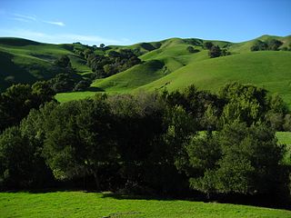
Briones Regional Park is a 6,117-acre (24.75 km2) regional park in the East Bay Regional Park District (EBRPD) system, located in the Briones Hills of central Contra Costa County of the San Francisco Bay Area in California.

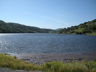
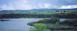
The San Pablo Reservoir is an open cut terminal water storage reservoir owned and operated by the East Bay Municipal Utility District (EBMUD). It is located in the valley of San Pablo Creek, north of Orinda, California, United States, and south of El Sobrante and Richmond, east of the Berkeley Hills between San Pablo Ridge and Sobrante Ridge.

Cull Canyon Regional Recreation Area (CCRRA) is a regional park located in Castro Valley, Alameda County, California. It is part of the East Bay Regional Park District (EBRPD) system.
Las Trampas Regional Wilderness is a 5,342-acre (21.62 km2) regional park located in Alameda and Contra Costa counties in Northern California. The nearest city is Danville, California. Las Trampas is Spanish for the traps, or the snares. The park belongs to the East Bay Regional Park District (EBRPD).

San Pablo Creek is an 18.7-mile-long (30.1 km) creek in Contra Costa County, California, United States, which drains the canyon or valley between the San Pablo Ridge and the Sobrante Ridge, parts of the Pacific Coast Ranges east of San Francisco Bay.

Pinole Creek is a stream in western Contra Costa County, in the East Bay region of the San Francisco Bay Area, California.

The Los Vaqueros Reservoir and watershed is located in the northern Diablo Range, within northeastern Contra Costa County, northern California. It was completed by the Contra Costa Water District (CCWD) in 1998 to improve the quality of drinking water for its 550,000 customers in Central and Eastern Contra Costa County. The reservoir is accessible via Vasco Road, a road which connects Brentwood and Livermore.

Uvas Reservoir is an artificial lake located west of Morgan Hill, California, in the United States. The reservoir is surrounded by a 626-acre (253 ha) park managed by the Santa Clara County Parks and Recreation Department. The park provides limited fishing ("catch-and-release"), picnicking, and hiking activities. Boating is not permitted in the reservoir.

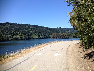
The Lafayette Reservoir is an open-cut human-made terminal water storage reservoir owned and operated by the East Bay Municipal Utility District (EBMUD). Completed in 1933, it was intended solely as a standby water supply for EBMUD customers. EBMUD opened the reservoir for public recreation in 1966. It is located off of California State Route 24 and a mile from the Lafayette BART station, in Contra Costa County, California, United States. This all-year, day-use area is ideal for hiking, jogging, fishing, boating and picnicking. The reservoir is on the Lafayette-Orinda border. The reservoir is on a 925-acre (3.74 km2) site and holds 1.4 billion US gallons (5,300,000 m3)

Pardee Dam is a 345-foot (105 m)-high structure across the Mokelumne River which marks the boundary between Amador and Calaveras Counties, located in the foothills of the Sierra Nevada approximately 30 miles (48 km) northeast of Stockton.

The Briones Hills form a low mountain range in western Contra Costa County, in the East Bay region of the San Francisco Bay Area, California, United States.
Chesbro Reservoir is an artificial lake located three miles (5 km) west of Morgan Hill, California, in the United States. A 232-acre (94 ha) county park surrounds the reservoir and provides limited fishing ("catch-and-release"), picnicking, and hiking activities. Swimming and boating are not permitted in the reservoir.

The Mokelumne Aqueduct is a 95-mile (153 km) water conveyance system in central California, United States. The aqueduct is supplied by the Mokelumne River and provides water to 35 municipalities in the East Bay in the San Francisco Bay Area. The aqueduct and the associated dams, pipelines, treatment plants and hydroelectric system are owned and operated by the East Bay Municipal Utility District (EBMUD) and provide over 90 percent of the water used by the agency.
Marsh Creek is a stream in east Contra Costa County, California in Northern California which rises on the eastern side of Mount Diablo and flows 30 miles (48 km) to the Sacramento–San Joaquin River Delta at Oakley, California, near Big Break Regional Shoreline. The creek flows through Marsh Creek State Park (California), where water is impounded to form Marsh Creek Reservoir, then through the city of Brentwood, California.

Upper San Leandro Reservoir is an artificial lake in Alameda County and Contra Costa County, California which provides water for the East Bay Municipal Utility District (EBMUD). It is impounded by the earth-filled San Leandro Dam on San Leandro Creek, located at the southeast end of the lake.


