
Scotts Bluff County is a county on the western border of the U.S. state of Nebraska. As of the 2020 United States Census, the population was 36,084. Its county seat is Gering, and its largest city is Scottsbluff.

Kensington is an unincorporated community and census designated place located in the Berkeley Hills, in the East Bay, part of the San Francisco Bay Area, in Contra Costa County, California. In the 20th century it was considered part of Berkeley, although it is across the county line. House numbers follow the pattern used in Berkeley, and Kensington shares two zip codes with the Berkeley Hills area.

The Oakland firestorm of 1991 was a large suburban wildland–urban interface conflagration that occurred on the hillsides of northern Oakland, California, and southeastern Berkeley over the weekend of October 19–20, 1991, before being brought under full control on October 23. The official name of this incident by Cal Fire is the Tunnel Fire. It is also commonly referred to as the Oakland Hills firestorm or the East Bay Hills fire. The fire ultimately killed 25 people and injured 150 others. The 1,520 acres destroyed included 2,843 single-family dwellings and 437 apartment and condominium units. The economic loss from the fire was estimated at $1.5 billion.

Charles Lee Tilden Regional Park, also known as Tilden Park or Tilden, [], is a 2,079-acre (841 ha) regional park in the East Bay, part of the San Francisco Bay Area in California. It is between the Berkeley Hills and San Pablo Ridge. Its main entrance is near Kensington, Berkeley, and Richmond. The park is contiguous with Wildcat Canyon Regional Park.

The Amargosa River is an intermittent waterway, 185 miles (298 km) long, in southern Nevada and eastern California in the United States. The Amargosa River is one out of two rivers located in the California portion of the Mojave Desert with perennial flow. It drains a high desert region, the Amargosa Valley in the Amargosa Desert northwest of Las Vegas, into the Mojave Desert, and finally into Death Valley where it disappears into the ground aquifer. Except for a small portion of its route in the Amargosa Canyon in California and a small portion at Beatty, Nevada, the river flows above ground only after a rare rainstorm washes the region. A 26-mile (42 km) stretch of the river between Shoshone and Dumont Dunes is protected as a National Wild and Scenic River. At the south end of Tecopa Valley the Amargosa River Natural Area protects the habitat.

Bernard Ralph Maybeck was an American architect. He worked primarily in the San Francisco Bay Area, designing public buildings, including the Palace of Fine Arts in San Francisco, and also private houses, especially in Berkeley, where he lived and taught at the University of California. A number of his works are listed on the National Register of Historic Places.

The Berkeley Hills are a range of the Pacific Coast Ranges, and overlook the northeast side of the valley that encompasses San Francisco Bay. They were previously called the "Contra Costa Range/Hills", but with the establishment of Berkeley and the University of California, the name was updated by geographers and gazetteers.

Temescal Creek is one of the principal watercourses in the city of Oakland, California, United States.

Lake Almanor is a large reservoir in northwestern Plumas County, northeastern California, United States. The reservoir has a capacity of 1,308,000 acre-feet (1.613×10⁹ m3) and a maximum depth of about 90 feet (27 meters). The surface area is 43.75 square miles (11,331.2 hectares). It is formed by Canyon Dam on the North Fork of the Feather River, as well as Benner and Last Chance Creeks, Hamilton Branch, and various natural springs.
Crystal Springs Reservoir is a pair of artificial lakes located in the northern Santa Cruz Mountains of San Mateo County, California operated by the San Francisco Public Utilities Commission for water supply to the San Francisco peninsula. The reservoirs are located in the rift valley created by the San Andreas Fault just to the west of the cities of San Mateo and Hillsborough, and I-280. The lakes are part of the San Mateo Creek watershed. Crystal Springs Regional Trail runs along the reservoir.

Carmel Highlands is an unincorporated community in Monterey County, California, United States. It is 3.5 miles (5.6 km) south of Carmel-by-the-Sea, at an elevation of 318 feet. Carmel Highlands is just south of the Point Lobos State Reserve, and serves as the northern gateway of the Big Sur coastline along California State Route 1. Carmel Highlands was laid out in 1916 by developers Frank Hubbard Powers and James Franklin Devendorf and the Carmel Development Company.

Hillside letters or mountain monograms are a form of hill figures common in the Western United States, consisting of large single letters, abbreviations, or messages displayed on hillsides, typically created and maintained by schools or towns. There are approximately 500 of these geoglyphs, ranging in size from a few feet to hundreds of feet tall. Hillside letters form an important part of the western cultural landscape, as they function as symbols of school pride and civic identity.
Wildcat Canyon is a narrow linear valley just east of the Berkeley Hills in the San Francisco Bay Area, situated in Contra Costa County, California. The canyon is bounded on its east side by the San Pablo Ridge, and is drained by Wildcat Creek which runs northwest to its outlet in San Pablo Bay. Two minor lakes or ponds lie along the creek: Jewel Lake and Lake Anza. The latter was enlarged by the construction of a small dam in the mid-20th century. An active tectonic fault, the Wildcat Fault, runs the length of the canyon. Wildcat Canyon was named for the mountain lions which used to be fairly common in the area. The southern end of the canyon adjacent to the city of Berkeley was incorporated into Tilden Regional Park in the 1930s and remains a major recreation area for local residents. Another regional park, Wildcat Canyon Regional Park, is situated at the northern end of the canyon.

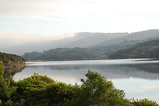
San Leandro Creek is a 21.7-mile-long (34.9 km) year-round natural stream in the hills above Oakland in Alameda County and Contra Costa County of the East Bay in northern California.

Wildcat Creek is a 13.4-mile-long (21.6 km) creek which flows through Wildcat Canyon situated between the Berkeley Hills and the San Pablo Ridge, emptying into San Pablo Bay in Contra Costa County, northern California.

Lake Anza is a recreational swimming reservoir, located within the Tilden Regional Park, in the Berkeley Hills above Berkeley, California.
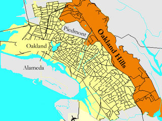
Oakland Hills is an informal term used to indicate the city neighborhoods lying within the eastern portion of Oakland, California. The northernmost neighborhoods were devastated by the Oakland firestorm of 1991.
Permanente Creek is a 13.3-mile-long (21.4 km) stream originating on Black Mountain in Santa Clara County, California, United States. Named by early Spanish explorers as Arroyo Permanente or Río Permanente because of its perennial flow, the creek descends the east flank of Black Mountain then courses north through Los Altos and Mountain View, discharging into southwest San Francisco Bay historically at the Mountain View Slough but now virtually entirely diverted via the Permanente Creek Diversion Channel to Stevens Creek and Whisman Slough in San Francisco Bay.


