
Charles Lee Tilden Regional Park, also known as Tilden Park or Tilden, [], is a 2,079-acre (841 ha) regional park in the East Bay, part of the San Francisco Bay Area in California. It is between the Berkeley Hills and San Pablo Ridge. Its main entrance is near Kensington, Berkeley, and Richmond. The park is contiguous with Wildcat Canyon Regional Park.

Lake Merced is a freshwater lake in the southwest corner of San Francisco, in the U.S. state of California. It is surrounded by three golf courses, as well as residential areas, Lowell High School, San Francisco State University, Lakeshore Alternative Elementary School, Stonestown Galleria, Fort Funston and the Pacific Ocean. The San Francisco Police Department shooting range, as well as a now closed skeet shooting club and the city's National Guard armory are also in the area. The lake was also the home of the Lake Merced Sailing Club, now closed, which provided training and racing for local sailors. Currently there is a paddling program operated by San Francisco State University. The lake is home of the Pacific Rowing Club and St. Ignatius College Prep Rowing Team, both competitive rowing programs for San Francisco high school students.

Stevens Creek Reservoir is an artificial lake located in the foothills of the Santa Cruz Mountains near Cupertino, California. A 1,063-acre (430 ha) county park surrounds the reservoir and provides limited fishing, picnicking, hiking, and horseback riding activities. Although swimming is not allowed, non-power boating is allowed for certain parts of the year. No powered boats or jet skis are allowed. All vessels must be inspected for invasive Quagga mussels prior to launch.

Cumberland Mountain State Park is a state park in Cumberland County, Tennessee, in the southeastern United States. The park consists of 1,720 acres (7.0 km2) situated around Byrd Lake, a man-made lake created by the impoundment of Byrd Creek in the 1930s. The park is set amidst an environmental microcosm of the Cumberland Plateau and provides numerous recreational activities, including an 18-hole Bear Trace golf course.

Buffalo River State Park is a state park of Minnesota, United States, conserving a prairie bisected by the wooded banks of the Buffalo River. Together with the adjacent Bluestem Prairie Scientific and Natural Area co-owned by The Nature Conservancy and Minnesota's Department of Natural Resources, it protects one of the largest and highest-quality prairie remnants in Minnesota. It used to offer a man-made swimming pond close to the Fargo–Moorhead metropolitan area, however, that has not been open since 2018. Presently, it is most popular for its high quality educational programming, swimming in the Buffalo River, and picnicking. The 1,068-acre (432 ha) park is located just off U.S. Route 10 in Clay County, 4.5 miles (7.2 km) east of Glyndon and 14 miles (23 km) east of Moorhead.

Lake Temescal is a small reservoir in the Oakland hills, in northeastern Oakland, California. It is the centerpiece of Temescal Regional Recreation Area, also known as Temescal Regional Park. It is a part of the East Bay Regional Park District.
Temescal Regional Recreation Area (TRRA), formerly Lake Temescal Regional Park, is a regional park in the Berkeley Hills, in northeastern Oakland, California. The TRRA encompasses 48 acres (19 ha), abutting SR 24, SR13, and the interchange connecting the two highways, southwest of the Caldecott Tunnel.The park is part of the East Bay Regional Park District (EBRPD).

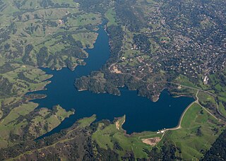
Folsom Lake is a reservoir on the American River in the Sierra Nevada foothills of California, United States. Folsom Lake with its surrounding Folsom Lake State Recreation Area is one of the most visited parks in the California park system.

San Francisquito Creek is a creek that flows into southwest San Francisco Bay in California, United States. Historically it was called the Arroyo de San Francisco by Juan Bautista de Anza in 1776. San Francisquito Creek courses through the towns of Portola Valley and Woodside, as well as the cities of Menlo Park, Palo Alto, and East Palo Alto. The creek and its Los Trancos Creek tributary define the boundary between San Mateo and Santa Clara counties.

San Mateo Creek is a perennial stream whose watershed includes Crystal Springs Reservoir, for which it is the only natural outlet after passing Crystal Springs Dam.
Briones Reservoir is an open cut terminal water storage reservoir located in western Contra Costa County, in the East Bay region of the San Francisco Bay Area, California.

Cull Canyon Regional Recreation Area (CCRRA) is a regional park located in Castro Valley, Alameda County, California. It is part of the East Bay Regional Park District (EBRPD) system.

Wildcat Creek is a 13.4-mile-long (21.6 km) creek which flows through Wildcat Canyon situated between the Berkeley Hills and the San Pablo Ridge, emptying into San Pablo Bay in Contra Costa County, northern California.
Puddingstone Reservoir is a 250-acre (1 km²) artificial lake northeast of the interchange between the Orange Freeway and the San Bernardino Freeway in Los Angeles County, California, United States. Activities include fishing, swimming, sailing, windsurfing, and camping. It is fed by Live Oak Wash and drains into Walnut Creek.
Lake Gregory is a reservoir in the San Bernardino National Forest of the San Bernardino Mountains in San Bernardino County, California. The lake and the surrounding area make up the Lake Gregory Regional Park adjacent to Crestline, California.
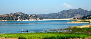
Santiago Dam is an earth/rockfill dam across Santiago Creek in Orange County, in the U.S. state of California, forming Irvine Lake. The 136-foot (41 m) earth dam and its reservoir serve for flood control and recreational purposes. It lies upstream (southeast) from the city of Orange and north of Irvine. Irvine Lake is the largest body of fresh water entirely in Orange County.
Crooked Lake is a recreational lake located in the south-eastern region of the Canadian province of Saskatchewan. It is part of a chain of lakes in the Qu'Appelle Valley and, like many of the other lakes in the valley, there's a dam at the eastern end that controls water levels.

Lockhart State Park is a state park located at the southwestern edge of Lockhart, Texas, United States and is administered by the Texas Parks and Wildlife Department. The park was constructed by Civilian Conservation Corps (CCC) Company 3803 between 1935 and 1938. The park officially became a state park in 1948.
Iverson Park is a recreational park course that lies on the green circle trail and Plover River in Stevens Point, Wisconsin. It spans over 100 acres, and contains a swimming area, hiking trails, as well as canoe and recreation activities rental. It is also known as the Plover Hills.
Thomson Lake is a reservoir in the Canadian province of Saskatchewan along the course of Wood River in the Old Wives Lake closed watershed. The lake was created in 1958 for irrigation and consumption with the damming of Wood River. It was named after Dr Leonard Thomson who was the director of the Prairie Farm Rehabilitation Administration (PFRA) at the time.


