Corte Madera Creek (Marin County, California)

Last updated
Corte Madera Creek
Rowers on Corte Madera Creek.jpg
Rowers on Corte Madera Creek
Relief map of California.png
Red pog.svg
Location of the mouth of Corte Madera Creek in California
Location
Country United States
State California
Region Marin County
Cities Ross, Kentfield, Corte Madera
Physical characteristics
Source confluence San Anselmo Creek and Ross Creek
 - location Ross
 - coordinates 37°57′58″N122°33′26″W / 37.96611°N 122.55722°W / 37.96611; -122.55722
 - elevation36 ft (11 m)
Mouth San Francisco Bay
 - location
Corte Madera, California
 - coordinates
37°56′30″N122°30′08″W / 37.94167°N 122.50222°W / 37.94167; -122.50222 Coordinates: 37°56′30″N122°30′08″W / 37.94167°N 122.50222°W / 37.94167; -122.50222 [1]
 - elevation
0 ft (0 m) [1]
Basin features
Tributaries 
 - left San Anselmo Creek
 - right Ross Creek, Tamalpais Creek [2] , Larkspur Creek [3]

Corte Madera Creek is a short stream which flows southeast for 4.5 miles (7.2 km) in Marin County, California. [4] Corte Madera Creek is formed by the confluence of San Anselmo Creek [5] and Ross Creek [6] in Ross and entering a tidal marsh at Kentfield before connecting to San Francisco Bay near Corte Madera. [7]

Marin County, California County in California, United States

Marin County is a county located in the San Francisco Bay Area of the U.S. state of California. As of the 2010 census, the population was 252,409. Its county seat is San Rafael. Marin County is included in the San Francisco-Oakland-Hayward, CA Metropolitan Statistical Area across the Golden Gate Bridge from San Francisco.

San Anselmo Creek river in the United States of America

San Anselmo Creek is an eastward-flowing stream that begins on the eastern flank of Pine Mountain in the Marin Hills of Marin County, California. At its confluence with Ross Creek, it becomes Corte Madera Creek.

Ross, California Town in California in the United States

Ross is a small incorporated town in Marin County, California, United States, just north of San Francisco. Ross is located 1.5 miles (2.4 km) west-southwest of San Rafael, at an elevation of 36 feet. The population was 2,415 at the 2010 census. The town is bordered by Kentfield and Greenbrae to the east, Larkspur to the south and San Anselmo to the north.

Contents

History

The Coast Miwok lived for thousands of years in the Corte Madera watershed, gathering pinole and acorns, hunting, and salmon-fishing. Traces of the Miwok include seven mounds in what is now the Town of Ross. [8]

Coast Miwok tribe of Native American people

The Coast Miwok are an indigenous people that was the second largest group of Miwok people. The Coast Miwok inhabited the general area of modern Marin County and southern Sonoma County in Northern California, from the Golden Gate north to Duncans Point and eastward to Sonoma Creek. The Coast Miwok included the Bodega Bay Miwok, from authenticated Miwok villages around Bodega Bay, and the Marin Miwok.

Pinole

Pinole, also called pinol or pinolillo, is roasted ground maize, which is then mixed with a combination of cocoa, agave, cinnamon, chia seeds, vanilla, or other spices. The resulting powder is then used as a nutrient-dense ingredient to make different foods, such as cereals, baked goods, tortillas, and beverages. The name comes from the Nahuatl word pinolli, meaning cornmeal. Today, pinole is generally made by hand using wood-burning adobe ovens and a stone and pestle, and is still consumed in certain, often rural, parts of Latin America. In fact, pinole is considered the national beverage of Nicaragua and Honduras.

Mound Artificial heaped pile of earth, gravel, sand, rocks, or debris

A mound is a heaped pile of earth, gravel, sand, rocks, or debris. Most commonly, mounds are earthen formations such as hills and mountains, particularly if they appear artificial. A mound may be any rounded area of topographically higher elevation on any surface. Artificial mounds have been created for a variety of reasons throughout history, including ceremonial, burial (tumulus), and commemorative purposes.

The Mexican government divided the northwest and southeast portions of the Corte Madera watershed into two separate land grants. The Rancho Cañada de Herrera, a 6,658-acre (26.94 km2) rancho that includes the areas that are now Fairfax, Sleepy Hollow, and part of San Anselmo, was granted to Domingo Sais in 1839. His family used the land for crops, sheep, horses, and cattle and fished San Anselmo Creek for salmon. [8] The Rancho Punta de Quentin, an 8,877-acre (35.92 km2) rancho established in 1840, was granted to Captain John B. R. Cooper, a sea captain from Boston, by Mexican Governor Juan Bautista Alvarado to repay a $5,250 debt. Cooper harvested timber and was also granted a license to hunt southern sea otter (Enhydra lutris nereis), then prevalent at the mouth of Corte Madera Creek. [9] Rancho Punta de Quentin is now the towns of San Anselmo, Ross, Kentfield, and Larkspur. [8]

Rancho Cañada de Herrera was a 6,658-acre (26.94 km2) Mexican land grant in present day Marin County, California given in 1839 by Governor pro tem Manuel Jimeno to Domingo Sais. The grant encompassed present day Fairfax, Sleepy Hollow and a part of San Anselmo.

Rancho Punta de Quentin was a 8,877-acre (35.92 km2) Mexican land grant in present-day Marin County, California given in 1840 by Governor Juan B. Alvarado to John B.R. Cooper. The grant comprised not only the San Quentin peninsula, but also present-day Ross, Kentfield and part of San Anselmo.

John B. R. Cooper American pioneer

John Bautista Rogers Cooper. Raised in Massachusetts in a maritime family, he came to the Mexican territory of Alta California as master of the ship Rover, and was a pioneer of Monterey, California when it was the capital of the territory. He converted to Catholicism, became a Mexican citizen, and married the daughter of the Mexican territorial governor and acquired extensive land holdings in the area prior to the Mexican–American War.

Corte Madera Creek is named for the Spanish corte de madera meaning "a place where wood is cut". [10]

A Tasmanian immigrant, James Ross, who had made a fortune selling liquor to gold panners in San Francisco, bought much of the Rancho Punta de Quentin in 1840 for $50,000. [9] [11] Ross continued logging and also started a regular schooner route to San Francisco to transport the wood. His family established an estate at the site that is now the Marin Art and Garden Center. [8]

Ecology

Pair of wood ducks (Aix sponsa) on the creek Wood Ducks on Corte Madera Creek Gary Leo 2010.jpg
Pair of wood ducks (Aix sponsa) on the creek
Steelhead trout in the creek Steelhead on Corte Madera Creek, Marin Gary Leo 2010.jpg
Steelhead trout in the creek

Corte Madera Creek is one of few streams flowing into San Francisco Bay with a steelhead trout (Oncorhynchus mykiss) population. The best spawning gravels are in Upper San Anselmo Creek, Ross Creek, and Sleepy Hollow Creek. Fairfax Creek has a total barrier to fish passage at its confluence with San Anselmo Creek. Larkspur Creek is rumored to have had steelhead long ago, and the occasional steelhead is still seen in Tamalpais Creek. Chinook salmon (Oncorhynchus tshawytscha) currently utilize the watershed. [12]

Larkspur Creek river in the United States of America

Larkspur Creek is a short stream which flows 3.5 miles east to meet Corte Madera Creek in Larkspur, California just before reaching Richardson's Bay. The creek was named for the town of Larkspur, which was named by Georgiana Wright, a Briton and spouse of the 1887 developer of the area. She named the town of Larkspur for lupine flowers on the hills that she mistook for larkspur.

Chinook salmon species of fish

The Chinook salmon is the largest species in the Pacific salmon genus Oncorhynchus. The common name refers to the Chinookan peoples. Other vernacular names for the species include king salmon, Quinnat salmon, spring salmon, chrome hog, and Tyee salmon. The scientific species name is based on the Russian common name chavycha (чавыча).

Historically, Corte Madera Creek watershed supported coho salmon (Oncorhynchus kisutch) with recorded observations dating from 1926-1927, the 1960s, 1981, and the last sighting in 1984. [13]

The main non-salmonid fish species in the Corte Madera Creek Watershed include the three-spined stickleback (Gasterosteus aculeatus), California roach (Lavinia symmetricus), several species of sculpin (Cottus spp.), and Sacramento sucker (Catostomus occidentalis occidentalis). [14]

The creek hosts many protected species in addition to steelhead trout, including at least 17 plants, northern spotted owls (Strix occidentalis caurina), San Pablo song sparrow (Melospiza melodia samuelis), Ridgway's rail (Rallus obsoletus) and black (Laterallus jamaicensis) rails, and the salt marsh harvest mouse (Reithrodontomys raviventris). The 1,000-acre (4.0 km2) Corte Madera Marsh Ecological Reserve is recognized as an Important Bird Area by the Audubon Society. [8] Just south of the marsh, there is a tidal channel named San Clement Creek where harbor seals (Phoca vitulina) haul out. [15]

Watershed

The Corte Madera (aka Ross Valley) Watershed ranges in elevation from sea level to 2,571 feet (784 m) at the East Peak of Mount Tamalpais. The watershed covers 28 square miles (73 km2) in the southeastern quarter of Marin County and encompasses the towns of Larkspur, Corte Madera, Kentfield, Ross, San Anselmo, and Fairfax. The watershed includes Corte Madera, Ross, San Anselmo, Tamalpais, Sleepy Hollow, Fairfax, and Cascade creeks and Phoenix Lake. Larkspur and Tamalpais creeks drain directly into the estuary/tidal portion. [14] The watershed includes 44 miles (71 km) of stream channels. Ross Creek drains the northern slope of Mt. Tamalpais; San Anselmo Creek and its tributaries drain the northwestern portion of the watershed. The two channels join to form Corte Madera Creek, which continues through more than a mile of concrete-lined channel past the confluences of Larkspur and Tamalpais Creeks and into the salt marsh at the mouth. [8]

See also

Related Research Articles

Lagunitas Creek river in the United States of America

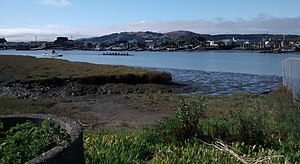
Lagunitas Creek is a 24 miles (39 km)-long northward-flowing stream in Marin County, California. It is critically important to the largest spawning runs of endangered coho salmon in the Central California Coast Coho salmon Evolutionary Significant Unit. The stream's headwaters begin on the northern slopes of Mt. Tamalpais in the Coast Range and terminate in southeast Tomales Bay, 1.5 miles (2.4 km) northwest of Point Reyes Station, California. Lagunitas Creek feeds several reservoirs on Mt. Tamalpais that supply a major portion of the county's drinking water.

Tamalpais Union High School District

The Tamalpais Union High School District or TUHSD provides high school education to students residing in ten elementary districts in central and southern Marin County, California and parts of West Marin. The headquarters are on the property of Redwood High School in Larkspur, California.

San Francisquito Creek river in the United States of America

San Francisquito Creek is a creek that flows into southwest San Francisco Bay in California, United States. Historically it was called the Arroyo de San Francisco by Juan Bautista de Anza in 1776. San Francisquito Creek courses through the towns of Portola Valley and Woodside, as well as the cities of Menlo Park, Palo Alto, and East Palo Alto. The creek and its Los Trancos Creek tributary define the boundary between San Mateo and Santa Clara counties.

Redwood Creek (Marin County)

Redwood Creek is a short but significant stream in Marin County, California. 4.7 miles (7.6 km) long, it drains a 7-square-mile (18 km2) watershed which includes the Muir Woods National Monument, and reaches the Pacific Ocean north of the Golden Gate at Muir Beach.

San Leandro Creek river in the United States of America

San Leandro Creek is a 21.7-mile-long (34.9 km) year-round natural stream in the Berkeley Hills, in Alameda County and Contra Costa County of the East Bay in northern California.

Arroyo Corte Madera del Presidio river in the United States of America

Arroyo Corte Madera del Presidio is a 4.1-mile-long (6.6 km) year-round stream in southern Marin County, California, United States. This watercourse is also known as Corte Madera Creek, although the actual stream of that name flows into San Francisco Bay further north at Point San Quentin. This watercourse has a catchment basin of about 8 square miles (21 km2) and drains the south-eastern slopes of Mount Tamalpais and much of the area in and around the town of Mill Valley; this stream discharges to Richardson Bay.

Wildcat Creek (California) river in the United States of America

Wildcat Creek is a 13.4-mile-long (21.6 km) creek which flows through Wildcat Canyon situated between the Berkeley Hills and the San Pablo Ridge, emptying into San Pablo Bay in Contra Costa County, northern California.

San Gregorio Creek river in the United States of America

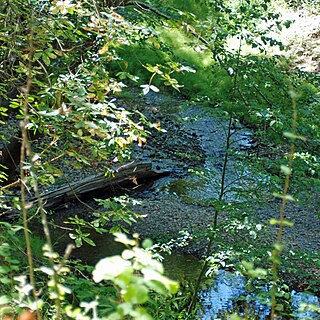
San Gregorio Creek is a river in San Mateo County, California. Its tributaries originate on the western ridges of the Santa Cruz Mountains whence it courses southwest through steep forested canyons. The San Gregorio Creek mainstem begins at the confluence of Alpine and La Honda Creeks, whence it flows 12 miles (19 km) through rolling grasslands and pasturelands until it meets the Pacific Ocean at San Gregorio State Beach. It traverses the small unincorporated communities of La Honda, San Gregorio, Redwood Terrace and Sky Londa.

Marin County, California contains many public and private schools and a few higher education institutions.

Coyote Creek (Marin County) river in Marin County, California, United States of America

Coyote Creek is a stream in the Richardson Bay watershed, draining Tamalpais-Homestead Valley, California eastward into Richardson Bay, Marin County, California, United States. The stream originates on Coyote Ridge and flows 2.5 miles (4.0 km) to the bay at the south end of Bothin Marsh.

Marsh Creek (California) river in the United States of America

Marsh Creek is a stream in east Contra Costa County, California in Northern California which rises on the eastern side of Mount Diablo and flows 30 miles (48 km) to the Sacramento–San Joaquin River Delta at Oakley, California, near Big Break Regional Shoreline. The creek flows through Marsh Creek State Park (California), where water is impounded to form Marsh Creek Reservoir, then through the city of Brentwood, California.

Searsville Dam

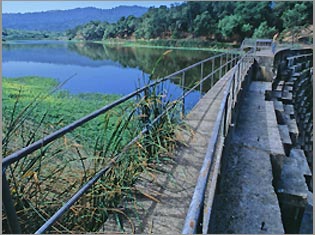
Searsville Dam is a masonry dam in San Mateo County, California that was completed in 1892, one year after the founding of Stanford University, and impounds Corte Madera Creek to form a reservoir known as Searsville Lake. Searsville Dam is located in the Jasper Ridge Biological Preserve and is owned and operated by Stanford University. Neighboring cities include Woodside and Portola Valley, California.

Corte Madera Creek (San Mateo County, California) river in the United States of America

Corte Madera Creek is a 7.3-mile-long (11.7 km) creek that flows north-northwest to Searsville Dam and then joins with Bear Creek to form San Francisquito Creek in California.

Bear Creek (San Francisquito Creek) stream originating north of the summit of Sierra Morena in the Santa Cruz Mountains

Bear Creek, or Bear Gulch Creek, is a 6.6-mile-long (10.6 km) southeastward-flowing stream originating north of the summit of Sierra Morena in the Santa Cruz Mountains, near the community of Kings Mountain in San Mateo County, California, United States. It flows through the town of Woodside. Bear Creek and Corte Madera Creek join to become San Francisquito Creek in the Jasper Ridge Biological Preserve at Stanford University.

Cascade Creek is a stream that flows south then southeast from its source on White Hill to its confluence with San Anselmo Creek just west of Fairfax in Marin County, California.

San Tomas Aquino Creek river in the United States of America

San Tomas Aquinas Creek, known locally as San Tomas Aquino Creek, is a 16.5-mile-long (26.6 km) stream that heads on El Sereno mountain in El Sereno Open Space Preserve in Saratoga, California in Santa Clara County, California, United States. It flows north through the cities of Saratoga, Monte Sereno, Los Gatos, Campbell, Santa Clara and San Jose before its confluence with the Guadalupe Slough in south San Francisco Bay.

Scott Creek (Santa Cruz County)

Scott Creek, also called Scotts Creek, is a 12.2-mile-long (19.6 km) stream and surfspot in Santa Cruz County, California. It is a few miles north of Davenport and a few miles south of Waddell Creek.

San Felipe Creek is a 14 miles (23 km) stream that originates in the western Diablo Range in Santa Clara County, California. It flows south by southeast through two historic ranchos, Rancho Los Huecos and Rancho Cañada de San Felipe y Las Animas before it joins Las Animas Creek just above Anderson Reservoir. One of the nine major tributaries of Coyote Creek, the creek’s waters pass through the Santa Clara Valley and San Jose on the way to San Francisco Bay.

References

  1. 1 2 U.S. Geological Survey Geographic Names Information System: Corte Madera Creek
  2. U.S. Geological Survey Geographic Names Information System: Tamalpais Creek
  3. U.S. Geological Survey Geographic Names Information System: Larkspur Creek
  4. Durham, David L. (1998). Durham's Place Names of California's San Francisco Bay Area: Includes Marin, San Francisco, San Mateo, Contra Costa, Alameda, Solano & Santa Clara counties. Word Dancer Press, Sanger, California. p. 44. ISBN   978-1-884995-35-4 . Retrieved 2010-08-30.
  5. U.S. Geological Survey Geographic Names Information System: San Anselmo Creek
  6. U.S. Geological Survey Geographic Names Information System: Ross Creek
  7. "Corte Madera Creek Watershed". Friends of Corte Madera Creek. Retrieved 2010-08-30.
  8. 1 2 3 4 5 6 "Ross Valley Watershed". Marin County Watershed Program. Retrieved 2010-09-03.
  9. 1 2 Bob Battersby, Preston Maginis, Susan Nielsen, Gary Scales, Richard Torney, and Ed Wynne (May 2008). Ross, California - The people, the places, the history. Ross Historical Society. Retrieved 2010-09-14.
  10. Erwin G. Gudde, William Bright (2004). California Place Names: The Origin and Etymology of Current Geographical Names. University of California Press. p. 92. ISBN   978-0-520-24217-3 . Retrieved 2010-08-30.
  11. John Dugan (2008-04-20). "New Book Tells History of Ross". Marin Independent Journal. Retrieved 2010-09-14.
  12. Robert A. Leidy (April 2007). "Ecology, Assemblage Structure, Distribution & Status of Fishes in Streams Tributary to the San Francisco Estuary". San Francisco Estuary Institute: 12. Retrieved 2010-09-14.
  13. Robert A. Leidy; Gordon Becker; Brett N. Harvey (2005). "Historical Status of Coho Salmon in Streams of the Urbanized San Francisco Estuary, California" (PDF). California Fish and Game: 219–254. Retrieved 2010-09-14.
  14. 1 2 Alice A. Rich (2000). Fishery Resources Conditions of the Corte Madera Creek Watershed, Marin County, California (PDF) (Report). Friends of Corte Madera Creek. Retrieved 2010-08-31.
  15. Corte Madera Watershed Resource Evaluation and Information Report (Report). San Francisco Bay Regional Water Quality Control Board. 2009-01-01. Retrieved 2010-09-14.