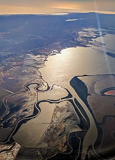
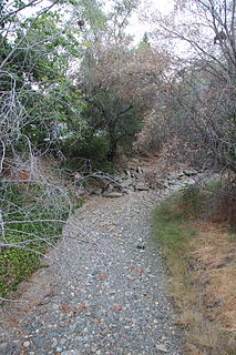
The Guadalupe Watershed consists of 170 square miles (400 km2) of land within northern California's Santa Clara County. This watershed is owned and managed by the Santa Clara Valley Water District. The surface runoff from this area drains into the various rivers (namely the Guadalupe), streams, reservoirs or other bodies of water which all eventually gets carried into the San Francisco Bay (indicated below, with surrounding counties in red). Essentially, all the water from the creeks and rivers that make up the Guadalupe watershed, including water from storm drains, flows into the Guadalupe River, and then flows downstream into the San Francisco Bay at the Alviso Slough in Alviso. The Guadalupe watershed's main tributaries include Los Gatos Creek, Trout Creek, Hendrys Creek, Ross Creek, Pheasant Creek, Rincon Creek, Herbert Creek, and Golf Creek. Six major reservoirs exist in the watershed: Calero Reservoir on Arroyo Calero, Guadalupe Reservoir on Guadalupe Creek, Almaden Reservoir on Los Alamitos Creek, Vasona Reservoir, Lexington Reservoir, and Lake Elsman on Los Gatos Creek.
The Santa Clara Valley Water District provides stream stewardship, wholesale water supply and flood protection for Santa Clara County, California, in the southern San Francisco Bay Area. The district encompasses all of the county's 1,300 square miles (3,400 km2) and serves the area's 15 cities, 1.9 million residents and more than 200,000 commuters. The district's three water treatment plants can produce as much as 210,000,000 US gallons (800,000 m3) of drinking water a day. Another part of the district's mission is to manage flood and storm waters along the county's hundreds of miles of creeks and rivers in an environmentally sensitive manner.

Surface runoff is the flow of water that occurs when excess stormwater, meltwater, or other sources flows over the Earth's surface. This might occur because soil is saturated to full capacity, because rain arrives more quickly than soil can absorb it, or because impervious areas send their runoff to surrounding soil that cannot absorb all of it. Surface runoff is a major component of the water cycle. It is the primary agent in soil erosion by water.
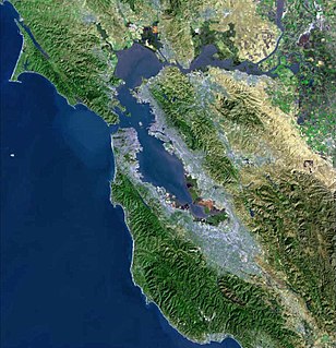
San Francisco Bay is a shallow estuary in the US state of California. It is surrounded by a contiguous region known as the San Francisco Bay Area, and is dominated by the large cities of San Jose, San Francisco and Oakland.
Contents
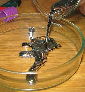
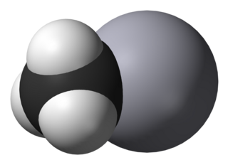
- Mercury contamination
- Health effects
- Environmental effects
- Santa Clara Valley Water District involvement
- References
- External links
The area covered by the Guadalupe River and its tributaries spreads over the neighboring cities of San Jose, Los Gatos, Monte Sereno, Campbell, and Santa Clara.
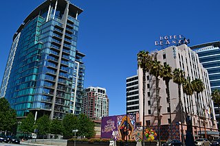
San Jose, officially the City of San José, is an economic, cultural and political center of Silicon Valley, and the largest city in Northern California. With an estimated 2017 population of 1,035,317, it is the third-most populous city in California and the tenth-most populous in United States. Located in the center of the Santa Clara Valley, on the southern shore of San Francisco Bay, San Jose covers an area of 179.97 square miles (466.1 km2). San Jose is the county seat of Santa Clara County, the most affluent county in California and one of the most affluent counties in the United States. San Jose is the most populous city in both the San Francisco Bay Area and the San Jose-San Francisco-Oakland Combined Statistical Area, which contain 7.7 million and 8.7 million people respectively.

Los Gatos is an incorporated town in Santa Clara County, California, United States. The population is 30,391 according to the 2013 United States Census Bureau. According to Bloomberg Businessweek, Los Gatos is ranked the 33rd wealthiest city in the United States. It is located in the San Francisco Bay Area at the southwest corner of San Jose in the foothills of the Santa Cruz Mountains, with a population of 41,544 as of 2017. Los Gatos is part of Silicon Valley, with several high technology companies maintaining a presence there. Most notably, streaming and content creator Netflix is headquartered in Los Gatos and has developed a large presence in the area.

Monte Sereno is a city in Santa Clara County, California, USA. The population was 3,341 at the 2010 census. The city is located in the foothills of the Santa Cruz Mountains, about 10 miles (16 km) southwest of San Jose, immediately northwest of Los Gatos, and southeast of Saratoga. The city is named for the 2,580-foot (790 m) El Sereno Mountain, upon the slopes of which the southern portion of the city is built. The community is entirely residential, with no commercial zoning and 99% single-family housing, and is an upscale Silicon Valley bedroom community. Monte Sereno shares the 95030 ZIP code with the town of Los Gatos. Many municipal services are provided under contract by Los Gatos.