
Marin County is a county located in the northwestern part of the San Francisco Bay Area of the U.S. state of California. As of the 2020 census, the population was 262,231. Its county seat and largest city is San Rafael. Marin County is across the Golden Gate Bridge from San Francisco, and is included in the San Francisco–Oakland–Berkeley, CA Metropolitan Statistical Area.

Lagunitas-Forest Knolls is a census-designated place, composed of two unincorporated areas in the western half of the San Geronimo Valley in Marin County, California. It is located to the west of San Geronimo and Woodacre. The population was 1,924 at the 2020 census.

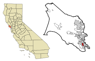
San Geronimo is a census-designated place (CDP) located in the San Geronimo Valley in Marin County, California in the United States. San Geronimo is bordered by Lagunitas-Forest Knolls to its west and Woodacre to its east. It is 8 miles (13 km) southwest of downtown Novato at an elevation of 292 feet (89 m). The population was 510 at the 2020 census.
Strawberry is a census-designated place (CDP) and an unincorporated district of Marin County, California, United States. It shares a ZIP code (94941) with Mill Valley and falls within its school districts; however, it is considered within the sphere of influence of the town of Tiburon. It is largely separated from Mill Valley by U.S. Route 101. Its population was 5,447 at the 2020 census.

Woodacre is an unincorporated town and census-designated place (CDP) in Marin County, California, United States. The population was 1,410 at the 2020 census.

San Geronimo Valley is located in Marin County, California, composed of four unincorporated towns: Woodacre, San Geronimo, Forest Knolls, and Lagunitas. It is a fairly close-knit community, with a rather liberal citizenry. The farther west one goes along the valley, the more forested the land becomes. The valley is bisected roughly east-to-west by Sir Francis Drake Boulevard; a number of streets in the towns along this road were constructed on the former right-of-way of the Northwestern Pacific Railroad. The valley has numerous hiking/biking trails. Most of the residents reside on the south, shadier, side of the valley.

Area codes 415 and 628 are telephone area codes in the North American Numbering Plan (NANP) for the city of San Francisco and its northern suburbs in Marin County, and the northeast corner of San Mateo County in the U.S. state of California. Area code 415 was one of the eighty-six original North American area codes established in 1947, but modified in geographic configuration later. Area code 628 was assigned in 2015 to form an overlay in that numbering plan area in mitigation of central office prefix exhaustion.

The North Bay is a subregion of the San Francisco Bay Area, in California, United States. The largest city is Santa Rosa, which is the fifth-largest city in the Bay Area. It is the location of the Napa and Sonoma wine regions, and is the least populous and least urbanized part of the Bay Area. It consists of Marin, Napa, Solano and Sonoma counties.

Lagunitas Creek is a 24-mile-long (39 km) northward-flowing stream in Marin County, California. It is critically important to the largest spawning runs of endangered coho salmon in the Central California Coast Coho salmon Evolutionary Significant Unit.

The North Coast of California is a region in Northern California that lies on the Pacific coast between San Francisco Bay and the Oregon border. It commonly includes Mendocino, Humboldt, and Del Norte counties and sometimes includes Lake and two counties from the San Francisco Bay Area, Marin and Sonoma.

The Tamalpais Union High School District or TUHSD provides high school education to students residing in ten elementary districts in central and southern Marin County, California and parts of West Marin. The headquarters are on the property of Redwood High School in Larkspur, California.

Lagunitas is an unincorporated community in Marin County, California. It is located 10 miles (16 km) southwest of Novato, at an elevation of 217 feet. Lagunitas is aggregated with Forest Knolls by the U.S. Census into the census-designated place (CDP) Lagunitas-Forest Knolls.

Sir Francis Drake Boulevard is an approximately 43.8 mile east–west arterial road in Marin County, California, running from the trailhead for Point Reyes Lighthouse at the end of the Point Reyes Peninsula to Interstate 580 just west of the Richmond-San Rafael Bridge. It is a main thoroughfare through the communities of Inverness, Point Reyes Station, Olema, Lagunitas-Forest Knolls, San Geronimo, Woodacre, Fairfax, San Anselmo, Ross, Kentfield, Greenbrae, and Larkspur. The road overlaps State Route 1 between Point Reyes Station and Olema.

Dogtown is an unincorporated community in the rural West Marin region of coastal Marin County, California in the San Francisco Bay Area's North Bay. It lies at an elevation of 187 feet. With a population of 30, the town is located beside the Golden Gate National Recreation Area and Point Reyes National Seashore, in the Olema Valley west of the Bolinas Ridge mountain range.

San Geronimo Creek is a stream in Marin County, California, United States, which feeds into Lagunitas Creek below Kent Lake.

Nicasio Creek is an 11.9-mile-long (19.2 km) stream in Marin County, California, United States and is the primary tributary of Lagunitas Creek, which flows, in turn, into Tomales Bay, and the Pacific Ocean. The Nicasio Reservoir, formed in 1961 by Seeger Dam, is located on this stream.
Olema Valley is a gorge formed by the San Andreas Fault in rural west Marin County, Northern California. The valley runs from the southern end of Tomales Bay through Point Reyes Station, the town of Olema, and Dogtown, to the Bolinas Lagoon, which lies between Bolinas and Stinson Beach. It is part of the Golden Gate National Recreation Area.

The Santa Rosa Transit Mall is a major transfer point for several bus routes serving the city of Santa Rosa, California, located in Sonoma County, north of San Francisco, in the United States. From the Transit Mall, passengers can travel throughout Santa Rosa and Sonoma County, plus destinations that connect the city with the rest of the San Francisco Bay Area and the Redwood Empire.
Rancho San Geronimo was a 8,701-acre (35.21 km2) Mexican land grant in present-day Marin County, California given in 1844 by Governor Manuel Micheltorena to Rafael Cacho. The grant extended along San Geronimo Creek.
The Lagunitas School District is a public K–8 school district located 18 miles northwest of San Francisco in western-central Marin County, California. The district serves students in the unincorporated San Geronimo Valley.


