The Avenue's southern terminus is at US101 near Phillipsville, north of Garberville. Its northern terminus is at US101 near Stafford, 15 miles (24km) south of Fortuna. The road parallels the scenic Eel River, and connects the small towns Phillipsville, Miranda, Myers Flat, Weott, Englewood, Redcrest and Pepperwood. The two-lane road has a number of parking areas, campgrounds, picnic sites, and attractions for visitors. The nearby river provides many swimming locations, such as those at the Rockefeller Forest redwood grove.
The route contains the site of the annual "Avenue of the Giants Marathon".[2]
Though not the oldest redwood in the forest, this large tree is at age millennium,[clarification needed] and is currently around 250ft (76m) tall, though originally it was much taller. It has survived not only the ravages of time but also a 1908 attempt at logging, the 1964 flood of the area, and a direct lightning strike which removed the top 45 feet (14m) of the tree (making its original height close to 300ft). It is from its age and perceived hardiness that the tree derives its name. Markers are visible on the tree, denoting the heights of where the loggers' axes and the floodwaters struck the tree.
Located in the northern half of the Avenue, The Immortal Tree is easy to find, and has a large gift shop and parking area situated in front of it.
Founder's Grove
Near Weott, this grove has an easy half-mile self-guided walk with informational booklets available at the beginning of the trail. The well-travelled trail is a good example of old-growth redwood forest and contains a few very large trees, including the Founder's Tree (346.1.ft. tall)[7] and the Dyerville Giant (c. 370ft. tall), which fell in 1991.
Drive-Through Tree
Avenue of the Giants features a tree that visitors can drive through. Shrine Drive-Thru Tree is near the town of Myers Flat. It is privately held; the owner charges $15 or more for a car to drive through it.
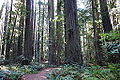
Avenue of the Giants passes through a redwood forest
Tree House
Not a traditional tree house, this is actually a house that is, albeit partially, built within a giant redwood.
Visible from the road, and with tours available, the front of the house is entered through the hollow trunk of a still-living tree. The front door and windows are clearly visible to passersby, and the rest of the house adjoins the rear of the tree in a more traditional style.
The Eel River is the third largest river in California. It carves deep canyons down great mountains, through flat valleys, and past ancient redwood forests. The Avenue of the Giants mainly follows the South Fork of the river, but does pass the confluence of the South and Main forks near its northern terminus.
History
The Avenue of the Giants was part of U.S. Route 101 until a freeway bypass was completed on August 27, 1960, assuming the 101 designation.[8] The Avenue was then designated as CA Route 254 by Assembly Concurrent Resolution 10.
Major intersections
Except where prefixed with a letter, postmiles were measured on the road as it was in 1964, based on the alignment that existed at the time, and do not necessarily reflect current mileage.R reflects a realignment in the route since then, M indicates a second realignment, L refers to an overlap due to a correction or change, and T indicates postmiles classified as temporary (for a full list of prefixes, see California postmile §Official postmile definitions).[1] Segments that remain unconstructed or have been relinquished to local control may be omitted.The entire route is in Humboldt County.
1 2 3 California Department of Transportation. "State Truck Route List". Sacramento: California Department of Transportation. Archived from the original(XLS file) on September 5, 2015. Retrieved June 30, 2015.
↑ Federal Highway Administration (March 25, 2015). National Highway System: California (North)(PDF) (Map). Scale not given. Washington, DC: Federal Highway Administration. Retrieved September 4, 2017.
↑ Natzke, Stefan; Neathery, Mike & Adderly, Kevin (June 20, 2012). "What is the National Highway System?". National Highway System. Washington, DC: Federal Highway Administration. Retrieved July 1, 2012.
This page is based on this Wikipedia article Text is available under the CC BY-SA 4.0 license; additional terms may apply. Images, videos and audio are available under their respective licenses.