
Fortuna is a city on the northeast shore of the Eel River, approximately 9 miles (14 km) from where it enters the Pacific Ocean, and is on U.S. Route 101 in west-central Humboldt County, California, United States. The population was 12,516 at the 2020 census, up from 11,926 at the 2000 census.
Rio Dell is a city in Humboldt County, California, United States. It is located on the west bank of the Eel River 1 mile (2 km) north of Scotia at an elevation of 161 feet. The population was 3,363 at the 2010 census, up from 3,174 at the 2000 census.

The Eel River is a major river, about 196 miles (315 km) long, of northwestern California. The river and its tributaries form the third largest watershed entirely in California, draining a rugged area of 3,684 square miles (9,540 km2) in five counties. The river flows generally northward through the Coast Ranges west of the Sacramento Valley, emptying into the Pacific Ocean about 10 miles (16 km) downstream from Fortuna and just south of Humboldt Bay. The river provides groundwater recharge, recreation, and industrial, agricultural and municipal water supply.
The California Western Railroad, AKA Mendocino Railway popularly called the Skunk Train, is a rail freight and heritage railroad transport railway in Mendocino County, California, United States, running from the railroad's headquarters in the coastal town of Fort Bragg to the interchange with the Northwestern Pacific Railroad at Willits.

The Navarro River is a 28.3-mile-long (45.5 km) river in Mendocino County, California, United States. It flows northwest through the Coastal Range to the Pacific Ocean. The main stem of the Navarro River begins less than 1 mile (2 km) south of the town of Philo at the confluence of Rancheria Creek and Anderson Creek. The mouth of the Navarro is 10 miles (16 km) south of the city of Mendocino. State Route 128 starts from the intersection of State Route 1 at the mouth of the Navarro River, and follows the river valley upstream to Philo. The river is close to the highway through the lower canyon but is some distance south of the highway as the Anderson Valley widens upstream of Wendling.

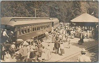
The Northwestern Pacific Railroad is a railroad covering the 62 mi (100 km) stretch between Schellville and Windsor with freight and Sonoma–Marin Area Rail Transit (SMART) commuter trains. Formerly, it was a regional railroad primarily used for logging that served the entire North Coast of California, with a main line running 271 miles (436 km) from Schellville to Eureka, along with an additional portion of the line running from the Ignacio Wye to the edge of San Rafael. The portion of the NWP main line between the Larkspur Station in Marin County and the depot in Healdsburg is currently owned by SMART. The Schellville–Ignacio and Healdsburg–Eureka portions are owned by the North Coast Railroad Authority (NCRA). Private contractor NWPco operates freight service under NCRA lease. California's 2018 Great Redwood Trail Act repurposes the abandoned railroad right-of-way from Eureka to the San Francisco Bay in Marin County for future use as the Great Redwood Trail.
The Pacific Lumber Company, officially abbreviated PALCO, and also commonly known as PL, was one of California's major logging and sawmill operations, located 28 miles (45 km) south of Eureka and 244 miles (393 km) north of San Francisco. Begun in 1863, PALCO was carefully managed over most of the twentieth century by generations of the Simon J. Murphy, Sr. Family or managers chosen by the Murphys from 1905 through 1985. Primary operations existed in massive log storage and milling operations at the historic company town of Scotia, California, located adjacent to US 101 along the Eel River. Secondary mills were located in nearby Fortuna and Carlotta. PALCO had extensive timber holdings exceeding well over 200,000 acres (890 km²) in the Redwood and Douglas-Fir forests of Humboldt County. For generations, it was one of the largest private employers in the entire region, appropriately known as the Redwood Empire.
The North Pacific Coast Railroad (NPC) was a common carrier 3 ft narrow-gauge steam railroad begun in 1874 and sold in 1902 to new owners who renamed it the North Shore Railroad (California) (NSR) and which rebuilt the southern section into a standard-gauge electric railway.

Scotia, formerly known as Forestville until 1888, is a census-designated place in Humboldt County, California. It is located on the Eel River along U.S. Route 101, 8.5 miles (13.7 km) southeast of Fortuna and 244 miles (393 km) north of San Francisco. Scotia has a population of 850.
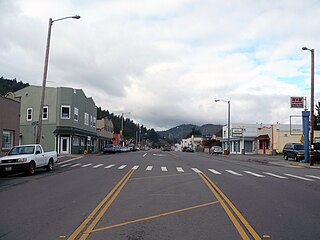
Alton is an unincorporated community in Humboldt County, California. It is located 3.5 miles (5.6 km) south-southeast of Fortuna, at an elevation of 62 feet. Alton is located along U.S. Route 101 and State Route 36. The ZIP Code is 95540. The community is inside area code 707.

San Francisco and North Pacific Railroad (SF&NP) provided the first extensive standard gauge rail service to Sonoma County and became the southern end of the regional Northwestern Pacific Railroad. Although first conceived of by Asbury Harpending, who had even obtained many of the right of ways, the SF & NP was bought and subsequently constructed by Peter Donahue, who drove the first spike on August 30, 1869.

San Francisco and Northwestern Railway (SF&NW) was an Atchison, Topeka and Santa Fe Railway subsidiary formed in 1903 to connect Humboldt Bay to the Santa Fe rail system.
The 1992 Cape Mendocino earthquakes occurred along the Lost Coast of Northern California on April 25 and 26. The three largest events were the M7.2 thrust mainshock that struck near the unincorporated community of Petrolia midday on April 25 and two primary strike-slip aftershocks measuring 6.5 and 6.6 that followed early the next morning. The sequence encompassed both interplate and intraplate activity that was associated with the Mendocino Triple Junction, a complex system of three major faults that converge near Cape Mendocino. The total number of aftershocks that followed the events exceeded 2,000.
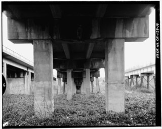
Island Mountain is a resistant formation of volcanic and metavolcanic rock in the Franciscan Assemblage of southwestern Trinity County, California. It was mined for sulfur metal deposits during the first half of the 20th century and was the final obstacle in the construction of a railroad line to Eureka, California in 1914. The name is applied to the range, the peak, a populated place and an abandoned railroad station, tunnel and bridge all but the first located within the S-bend of the Eel River which gave the peak its name.
The Caspar, South Fork & Eastern Railroad provided transportation for the Caspar Lumber Company in Mendocino County, California. The railroad operated the first steam locomotive on the coast of Mendocino County in 1875. Caspar Lumber Company lands became Jackson Demonstration State Forest in 1955, named for Caspar Lumber Company founder, Jacob Green Jackson.

Metropolitan is an unincorporated community in Humboldt County, California. It is located on McDairmid Prairie, on the north side of the Eel River floodplain three miles downstream of Scotia, at an elevation of 72 feet.
Southern Pacific Transportation Company formed the Oregon and Eureka Railroad in 1903 in an agreement to use logging railroads as part of a line connecting Humboldt County (California) sawmills with the national rail network. Northwestern Pacific Railroad offered service over the route from 1911 through 1933. The northern 6-mile (9.7 km) of the line remained in use as a Hammond Lumber Company logging branch until 1948.

The Christmas flood of 1964 was a major flood in the United States' Pacific Northwest and some of Northern California between December 18, 1964, and January 7, 1965, spanning the Christmas holiday. Considered a 100-year flood, it was the worst flood in recorded history on nearly every major stream and river in coastal Northern California and one of the worst to affect the Willamette River in Oregon. It also affected parts of southwest Washington, Idaho, and Nevada. In Oregon, 17 or 18 people died as a result of the disaster, and it caused hundreds of millions of dollars in damage. The flooding on the Willamette covered 152,789 acres (61,831.5 ha). The National Weather Service rated the flood as the fifth most destructive weather event in Oregon in the 20th century. California Governor Pat Brown was quoted as saying that a flood of similar proportions could "happen only once in 1,000 years," and it was often referred to later as the Thousand Year Flood. The flood killed 19 people, heavily damaged or completely devastated at least 10 towns, destroyed all or portions of more than 20 major highway and county bridges, carried away millions of board feet of lumber and logs from mill sites, devastated thousands of acres of agricultural land, killed 4,000 head of livestock, and caused $100 million in damage in Humboldt County, California, alone.

The Eel River and Eureka Railroad company was organized on November 14, 1882, by a group of Eureka businessmen led by John M. Vance. One of the other founders of the line was William Carson.
Mendocino Lumber Company operated a sawmill on Big River near the town of Mendocino, California. The sawmill began operation in 1853 as the Redwood Lumber Manufacturing Company, and changed ownership several times before cutting its final logs in 1938. The sawmill site became part of the Big River Unit of Mendocino Headlands State Park where a few features of the mill and its associated forest railway are still visible along the longest undeveloped estuary in northern California.
