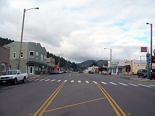
Arcata is a city adjacent to the Arcata Bay (northern) portion of Humboldt Bay in Humboldt County, California, United States. At the 2020 census, Arcata's population was 18,857. Arcata was first settled in 1850 as Union, was officially established in 1858, and was renamed Arcata in 1860. It is located 280 miles (450 km) north of San Francisco, and is home to California State Polytechnic University, Humboldt. Arcata is also the location of the Arcata Field Office of the Federal Bureau of Land Management, which is responsible for the administration of natural resources, lands and mineral programs, including the Headwaters Forest, on approximately 200,000 acres (810 km2) of public land in Northwestern California.

Blue Lake is a city in Humboldt County, California, United States. Blue Lake is located on the Mad River in a deep valley, 16 miles (26 km) northeast of Eureka, at an elevation of 131 feet. Its population is 1,208 as of the 2020 census, down from 1,253 from the 2010 census.

Cutten, a census-designated place (CDP) in Humboldt County, California, United States, is an unincorporated community, which is part of Greater Eureka. The city was named for David Page Cutten and his family, who were prominent figures in the history of Humboldt County during the early 1850s. Cutten is located 2.5 miles (4 km) south-southeast of downtown Eureka, at an elevation of 200 feet. Its population is 3,223 as of the 2020 census, up from 3,108 from the 2010 census.

Humboldt Hill is a census-designated place (CDP) in Humboldt County, California, United States. Humboldt Hill rises to an elevation of 636 feet (194 m). The population was 3,414 at the 2010 census, up from 3,246 at the 2000 census. The area is in the 95503 zip code and part of unincorporated Eureka.

Hydesville is a census-designated place (CDP) in Humboldt County, California, United States. Hydesville is located 4.5 miles (7.2 km) southeast of Fortuna, at an elevation of 364 feet (111 m). The population was 1,237 at the 2010 census, up from 1,209 at the 2000 census.

McKinleyville is a census-designated place (CDP) in Humboldt County, California McKinleyville is located 5.25 miles (8.4 km) north of Arcata, at an elevation of 141 feet (43 m). The population was 15,177 at the 2010 census, up from 13,599 at the time of the 2000 census.

Pine Hills is a census-designated place (CDP) in Humboldt County, California, United States, adjacent to Eureka. The population was 3,131 at the 2010 census, up from 3,108 at the 2000 census. Pine Hills includes areas like Ridgewood and areas as far south as the small neighborhood of Elk River. An area near this artificial census construct is called Pine Hill by Local government agencies and officials. Pine Hill is a much smaller area than "Pine Hills" and as defined by local agencies is actually within an adjacent CDP named Bayview.

Rio Dell is a city in Humboldt County, California, United States. It is located on the west bank of the Eel River 1 mile (2 km) north of Scotia at an elevation of 161 feet. The population was 3,363 at the 2010 census, up from 3,174 at the 2000 census.
Alderpoint is a census-designated place in Humboldt County, California at an elevation of 472 feet (144 m), 11 miles (18 km) east-northeast of Garberville. Its population is 137 as of the 2020 census, down from 186 from the 2010 census. The ZIP Code is 95511 and its area code is 707.

Loleta is a census-designated place in Humboldt County, California. Loleta is located 5.5 miles (9 km) south of Fields Landing, and 15 miles (24 km) south of Eureka at an elevation of 46 feet (14 m). The population was 783 at the 2010 census. Residents live in a central community area and rural outskirts. There are two separate Native American reservations on the rural outskirts of Table Bluff, California.

Fieldbrook is a census-designated place in Humboldt County, California. It is located 7 miles (11 km) north-northeast of Arcata, at an elevation of 203 feet (62 m). The population was at 860 at the 2010 census.

Samoa is a census-designated place in Humboldt County, California. It is located 1.5 miles (2.4 km) northwest of Eureka, at an elevation of 23 feet. Samoa is located in the northern peninsula of Humboldt Bay and is the site of the Samoa Cookhouse, one of the last remaining original, lumber-camp style cookhouses. The name Samoa is used interchangeably with the peninsula it occupies. The population was 258 at the 2010 census.
Mad River is a census-designated place (CDP) in Trinity County, California. Mad River is located in the southern part of the county. Mad River sits at an elevation of 2,484 feet (757 m). The ZIP Code is 95552. Its population is 361 as of the 2020 census, down from 420 from the 2010 census.
Phillipsville is a census-designated place in Humboldt County, California. It is located on the South Fork of the Eel River 7.5 miles (12.1 km) north of Garberville, at an elevation of 289 feet. It is the southernmost town on the Avenue of the Giants. Near the town is the Chimney Tree. This is a redwood tree that resembles a chimney. The ZIP Code is 95559. The community is inside area code 707. The population was 140 at the 2010 census.
Myers Flat is a census-designated place in Humboldt County, California. It is located 4.5 miles (7.2 km) south-southeast of Weott, at an elevation of 203 feet. The ZIP Code is 95554. The population was 146 at the 2010 census.

Redcrest is a census-designated place in Humboldt County, California. It is located 5.5 miles (8.9 km) north of Weott, at an elevation of 377 feet. The population was 89 at the 2010 census.

Leggett is a census-designated place in Mendocino County, California. It is located on the South Fork of the Eel River, 17 miles (27 km) northwest of Laytonville, at an elevation of 984 ft (300 m). It is home to some of the largest trees in the world. The nearby Smithe Redwoods State Reserve and the Standish-Hickey State Recreation Area are noted for their forests of Coastal Redwoods. The population was 77 at the 2020 census.

Benbow is a census-designated place in Humboldt County, California, located beside the South Fork Eel River. It is located 2 miles (3.2 km) south-southeast of Garberville, at an elevation of 440 feet. Its population is 422 as of the 2020 census, up from 321 from the 2010 census.

Big Lagoon is a census-designated place in Humboldt County, California. It is located 7 miles (11 km) north of Trinidad, at an elevation of 56 feet (17 m). Its population is 161 as of the 2020 census, up from 93 from the 2010 census.

Manila is a census-designated place located adjacent to Humboldt Bay in Humboldt County, California. It is located 3.25 miles (5.2 km) north of downtown Eureka, at an elevation of 13 feet. The ZIP Code is 95521. The population was 784 at the 2010 census.


