Related Research Articles
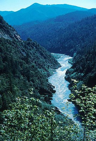
The Klamath River flows 257 miles (414 km) through Oregon and northern California in the United States, emptying into the Pacific Ocean. By average discharge, the Klamath is the second largest river in California after the Sacramento River. It drains an extensive watershed of almost 16,000 square miles (41,000 km2) that stretches from the arid country of south-central Oregon to the temperate rainforest of the Pacific coast. Unlike most rivers, the Klamath begins in the high desert and flows toward the mountains – carving its way through the rugged Cascade Range and Klamath Mountains before reaching the sea. The upper basin, today used for farming and ranching, once contained vast freshwater marshes that provided habitat for abundant wildlife, including millions of migratory birds. Most of the lower basin remains wild, with much of it designated wilderness. The watershed is known for this peculiar geography, and the Klamath has been called "a river upside down" by National Geographic magazine.
The Atsugewi are Native Americans residing in northeastern California, United States. Their traditional lands are near Mount Shasta, specifically the Pit River drainage on Burney, Hat, and Dixie Valley or Horse Creeks. They are closely related to the Achomawi and consisted of two groups. The Atsugé traditionally are from the Hat Creek area, and the Apwaruge are from the Dixie Valley. They lived to the south of the Achomawi.
Weitchpec ( WETCH-pek is an unincorporated community within the Yurok reservation in Humboldt County, California, United States. It is located 35 miles northeast of Eureka, at an elevation of 361 feet. The ZIP Code is 95546.
Hupa are a Native American people of the Athabaskan-speaking ethnolinguistic group in northwestern California. Their endonym is Natinixwe, also spelled Natinook-wa, meaning "People of the Place Where the Trails Return". The Karuk name was Kishákeevar / Kishakeevra. The majority of the tribe is enrolled in the federally recognized Hoopa Valley Tribe.

The Yurok Indian Reservation is a Native American reservation for the Yurok people located in parts of Del Norte and Humboldt counties, California, on a 44-mile (71 km) stretch of the Klamath River. It is one of a very few tribes who have never been removed from their ancestral lands in California.

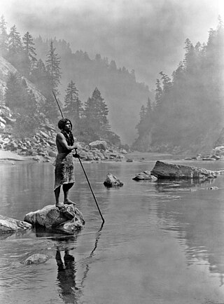
The Yurok are an Indigenous people from along the Klamath River and Pacific coast, whose homelands are located in present-day California stretching from Trinidad in the south to Crescent City in the north.
Yurok traditional narratives include myths, legends, tales, and oral histories preserved by the Yurok people of the lower Klamath River in northwestern California.

Ah Pah Dam was a proposed dam on the Klamath River in the U.S. state of California proposed by the United States Bureau of Reclamation as part of its United Western Investigation study in 1951. It was to have been 813 feet (248 m) high and was to be located 12 miles (19 km) upstream of the river's mouth. It would be taller than any dam in the United States and it would stand almost as tall as the Transamerica Pyramid building in San Francisco, but would be much more massive. It would flood 40 miles (64 km) of the Trinity River, including the Yurok, Karuk and Hupa Indian Reservations, the lower Salmon River, and 70 miles (110 km) of the Klamath River, creating a reservoir with a volume of 15,000,000 acre-feet (19 km3) – three fifths the size of Lake Mead, and over three times the size of the current largest reservoir in California, Shasta Lake. The water would flow by gravity through a tunnel 60 miles (97 km) long to the Sacramento River just above Redding and onward to Southern California, in an extreme diversion plan known as the Klamath Diversion. The tunnel would have been located near the southernmost extent of the reservoir. It was named in the language of the Yurok people.
Eshpeu is a former Yurok settlement in Humboldt County, California. It was located at Gold Bluff between the mouths of the Klamath River and Redwood Creek. Espa Lagoon is near the site of Eshpeu.
Johnsons is an unincorporated community in Humboldt County, California. It is located on the Klamath River 14 miles (23 km) northwest of Weitchpec, at an elevation of 180 feet.
Loolego is a former Yurok settlement in Humboldt County, California. It was located on the Lower Klamath River 2 mi (3.2 km) above the fork with the Trinity River. T. T. Waterman noted that the name, Lo'-o-le'-go, translates to "where they build a fish weir." It was about 2 miles upstream of the confluence of the Klamath and Trinity rivers and must at one time have been a substantial settlement because the inhabitants were public performers at the deerskin ceremony at wē-itspūs. 30 years before his 1909 visit, there had been two house pits and a sweat lodge foundation, but but hydraulic placer mining had washed away the soil down to bedrock in the 1880s. Sherburne F. Cook wrote that the population of Loolego declined rapidly after white settlement.
Mettah is a former settlement in Humboldt County, California. It was located 10 miles (16 km) east of Orick and 3 miles (4.8 km) south of Johnsons, at an elevation of 207 feet (63 m).
Notchko is a locality in Humboldt County, California. It is located on the Klamath River 4 miles (6.4 km) south of Johnsons, at an elevation of 151 feet (46 m). It is located on the Yurok Indian Reservation and was a significant Yurok burial site for generations; like many locales in the area, it was heavily damaged in the Christmas flood of 1964, with the remaining residents being offered sub-standard replacement housing without utilities.
Oketo is a former Yurok settlement in Humboldt County, California, but experts differ on the names of the settlement and what is now called Big Lagoon. Yurok author Chenahwah Weitchahwah used the name Ah-ca-tah but was unclear whether she was naming the village or lagoon. Peter Palmquist mapped it to the south shore. A. L. Kroeber said it was called Opyuweg, pinpointing it in more detail. T. T. Waterman mapped it most precisely as Opyuweg and set it west of a southern promontory of the lagoon and of a settlement called piNpa. According to Waterman, Oketo was the name of the lagoon. Weitchahwah said a major religious performance called Wah-neck-wel-ah-gaw was performed there biannually and, when Europeans first arrived, it was also still held at Orick, Reck-woy, and Pec-wan.
Pecwan is a locality in Humboldt County, California. It is located on the Klamath River near the mouth of Pecwan Creek 1 mile (1.6 km) east-southeast of Johnsons, at an elevation of 869 feet (265 m).
Pekwan is a former Yurok settlement in Humboldt County, California. It is located on the Lower Klamath River at the mouth of Pecwan Creek, at an elevation of 85 feet.
Pekwuteu is a former Yurok settlement in Humboldt County, California. It was located on the Lower Klamath River opposite town of Weitchpec, at an elevation of 348 feet.
Copper Creek is a southern tributary of the Klamath River in the U.S. state of California. Arising in the Klamath Mountains, the creek drains a narrow watershed of about 120 square miles (310 km2). Historically, Copper Creek was the site of at least one Hupa Native American village, then was extensively mined for gold in the 1850s. The origin of the name comes from the peach-colored cliffs that line the lower few miles of the canyon.
Black Bear was a gold mining town in Klamath County, now in unincorporated Siskiyou County, California.
Blue Creek is a 23-mile (37 km) long stream in the Northern Coast Ranges of California, and is the lowermost major tributary of the Klamath River. The creek begins in Elk Valley, in the Siskiyou Wilderness of the Six Rivers National Forest in Del Norte County. It flows southwest, receiving several major tributaries including the East Fork, Crescent City Fork, Nickowitz Creek, Slide Creek and the West Fork. It flows into the Klamath River in Humboldt County, 16 miles (26 km) upstream from where the Klamath empties into the Pacific Ocean.
References
- 1 2 Alfred Louis Kroeber (1925). Handbook of the Indians of California. The Internet Archive. Courier Dover Publications. pp. 9–. ISBN 978-0-486-23368-0.
- ↑ U.S. Geological Survey Geographic Names Information System: Atsepar, California
- ↑ Waterman, T. T. (May 31, 1920). "Yurok Geography". University of California Publications in American Archaeology and Ethnography. 16 (5): 177–314 – via HathiTrust.

41°13′40″N123°39′23″W / 41.2279°N 123.6565°W
| | This Humboldt County, California–related article is a stub. You can help Wikipedia by expanding it. |