
Klamath County was a county of California from 1851 to 1874. During its existence, the county seat moved twice and ultimately portions of the territory it once had were carved up and added to nearby counties. It was formed from the northwestern portion of Trinity County, and originally included all of the northwestern part of the state, from the Mad River in the south to Oregon in the north, from the Pacific Ocean in the west to the middle of what is now Siskiyou County in the east. It is the only county in California to be disestablished.

The Illinois River is a tributary, about 56 miles (90 km) long, of the Rogue River in the U.S. state of Oregon. It drains part of the Klamath Mountains in northern California and southwestern Oregon. The river's main stem begins at the confluence of its east and west forks near Cave Junction in southern Josephine County. Its drainage basin includes Sucker Creek, which rises in the Red Buttes Wilderness, near Whiskey Peak on the California state line. The main stem flows generally northwest in a winding course past Kerby and through the Siskiyou National Forest and Kalmiopsis Wilderness. It joins the Rogue River from the south at Agness on the Curry–Josephine county line, 27 miles (43 km) from the Pacific Ocean.

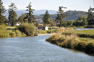
The Alsea River flows 48.5 miles (78.1 km) from Alsea, an unincorporated community in the coastal mountains of the U.S. state of Oregon, to the Pacific Ocean near the city of Waldport. It begins at the confluence of the North Fork Alsea River and the South Fork Alsea River and ends in Alsea Bay, a wide estuary at Waldport. The river flows generally west-northwest in a winding course through the mountains of southern Benton and Lincoln counties, passing near the unincorporated community of Tidewater and through the Siuslaw National Forest. Its drainage basin extends into Lane County, along the headwaters of the South Fork Alsea River.
The Trask River is in northwestern Oregon in the United States. It drains a mountainous timber-producing area of the Northern Oregon Coast Range west of Portland into Tillamook Bay and the Pacific Ocean. It is one of five rivers—the Tillamook, the Trask, the Wilson, the Kilchis, and the Miami—that flow into the bay.
Forks of Salmon is an unincorporated community of Siskiyou County in northern California, USA. The town is situated at the confluence of the north and south forks of the Salmon River, hence its name. The ZIP Code is 96031. The community is inside area code 530.
Van Damme State Park consists of about 1,831 acres (7.41 km2) of land in Mendocino County, California, near the town of Little River on State Route 1. It was named for Charles Van Damme (1881–1934), who was born in the area and purchased the land that is now the park with profits from a San Francisco ferry business. On his death, the property became part of the California state park system.
The Yurok Tribe of the Yurok Reservation' is located in parts of Del Norte and Humboldt counties, California, on a 44-mile (71 km) stretch of the Klamath River. It is a rancheria of Yurok people and a federally recognized tribe.

Ah Pah Dam was a proposed dam on the Klamath River in the U.S. state of California proposed by the United States Bureau of Reclamation as part of its United Western Investigation study in 1951. It was to have been 813 feet (248 m) high and was to be located 12 miles (19 km) upstream of the river's mouth. It would stand almost as tall as the Transamerica Pyramid building in San Francisco, but would be much more massive. It would flood 40 miles (64 km) of the Trinity River, including the Yurok, Karuk and Hupa Indian Reservations, the lower Salmon River, and 70 miles (110 km) of the Klamath River, creating a reservoir with a volume of 15,000,000 acre feet (19 km3) – two-thirds of the size of Lake Mead, and becoming the largest reservoir in California. The water would flow by gravity through a tunnel 60 miles (97 km) long to the Sacramento River just above Redding and onward to Southern California, in an extreme diversion plan known as the Klamath Diversion. The tunnel would have been located near the southernmost extent of the reservoir. It was named in the language of the Yurok people.
The Clowhom River is a short, 19.8-kilometre (12.3 mi) river in British Columbia. It flows into the head of the Salmon Inlet about 26.2 km west of Squamish.

Klamath Glen is an unincorporated community in Del Norte County, California. It is located on the Klamath River 5 miles (8 km) from its mouth, at an elevation of 46 feet.
Kworatem is a former Karok settlement in Humboldt County, California. It was located at the confluence of the Klamath and Salmon Rivers, at an elevation of 515 feet.
Pecwan is a locality in Humboldt County, California. It is located on the Klamath River near the mouth of Pecwan Creek 1 mile (1.6 km) east-southeast of Johnsons, at an elevation of 869 feet (265 m).
Shregegon is a former Yurok settlement in Humboldt County, California. It was located about 1 mile (1.6 km) above the mouth of Pecwan Creek, at an elevation of 125 feet.

Del Mar Landing State Marine Reserve (SMR) is a marine protected area that lies onshore, about two miles south of the town of Gualala and three and a half miles north of Sea Ranch in Sonoma County on California’s north central coast. The marine protected area covers 0.22 square miles (0.57 km2). Del Mar Landing SMR prohibits the take of all living marine resources.

Russian River State Marine Recreational Management Area (SMRMA) and Russian River State Marine Conservation Area (SMCA) are two adjoining marine protected areas in the Russian River estuary area in Sonoma County, California, on the north-central coast of the state. The combined area of these marine protected areas is 1.21 square miles (3.1 km2), with 0.35 square miles (0.91 km2) in the SMRMA and 0.86 square miles (2.2 km2) in the SMCA.
The Klamath River is a river in southern Oregon and northern California in the United States. This article describes its course.

Copper Creek is a southern tributary of the Klamath River in the U.S. state of California. Arising in the Klamath Mountains, the creek drains a narrow watershed of about 120 square miles (310 km2). Historically, Copper Creek was the site of at least one Hupa Native American village, then was extensively mined for gold in the 1850s. The origin of the name comes from the peach-colored cliffs that line the lower few miles of the canyon.
Gullion's Bar was a placer gold mining camp on the Salmon River, now located in Siskiyou County, California. It was located originally in Trinity County, in 1850.
The North Fork Salmon River is a 36.9-mile (59.4 km) river in Siskiyou County, California. It joins with the South Fork Salmon River at Forks of Salmon to form the Salmon River, a major tributary of the Klamath River. Originating at English Lakes near 7,322-foot (2,232 m) English Peak in the Salmon Mountains, the North Fork drains about 204 square miles (530 km2) of rugged, forested terrain. The entire river is located within the Klamath National Forest, with the headwaters located in the Marble Mountain Wilderness.
The South Fork Salmon River is a 39.5-mile (63.6 km) river in Siskiyou County, California and is the larger of two tributaries that join to form the Salmon River, the other being the North Fork. It begins in the Salmon Mountains, on the border of Siskiyou and Trinity County, about 15 miles (24 km) southeast of Cecilville, and flows generally northwest through the Salmon Mountains to its confluence with the North Fork at Forks of Salmon. The South Fork drains an area of 290 square miles (750 km2), located entirely in the Klamath National Forest, with a significant portion in the Trinity Alps Wilderness.


