
Cooper County is a county located in the central portion of the U.S. state of Missouri. As of the 2010 census, the population was 17,601. Its county seat is Boonville. The county was organized December 17, 1818 and named for Sarshell Cooper, a frontier settler who was killed by Native Americans near Arrow Rock in 1814. It is a part of the Columbia, Missouri metropolitan area.

Covelo is a census-designated place (CDP) in Mendocino County, California, United States. Covelo is located 14 miles (23 km) east-northeast of Laytonville, at an elevation of 1,398 feet. The population was 1,255 at the 2010 census, up from 1,175 at the 2000 census. 405 acres (1.64 km2) of Covelo is part of the Round Valley Indian Reservation.

Sequim is a city in Clallam County, Washington, United States. The 2010 census counted a population of 6,606. With the surrounding area, the population is about 28,000. Sequim is located along the Dungeness River near the base of the Olympic Mountains. The population served by the Sequim School District population was over 26,000 in 2018.

The Abitibi River is a river in northeastern Ontario, Canada, which flows northwest from Lake Abitibi to join the Moose River which empties into James Bay. This river is 540 kilometres (340 mi) long, and descends 265 metres (869 ft).
The Artificial Reef Society of British Columbia (ARSBC) is a registered non-profit society based in Vancouver, British Columbia (BC), and is a registered tax-deductible charity in Canada.

The Elk/Beaver Regional Park is a 1,072 acres (4.34 km2) park in Saanich, British Columbia, containing Elk Lake and Beaver Lake.

Tippecanoe Township is one of thirteen townships in Tippecanoe County, Indiana, United States. As of the 2010 census, its population was 7,702 and it contained 3,085 housing units.

A seagull intersection or continuous green T-intersection is a type of three-way road intersection, usually used on high traffic volume roads and dual carriageways. This form of intersection is popular in Australia and New Zealand, and sometimes used in the United States and other countries.

Elk River is an unincorporated community in Humboldt County, California. It is located 2.25 miles (3.6 km) east-northeast of Fields Landing, at an elevation of 69 feet. All the residents of this neighborhood have Eureka, California addresses.
Englewood is an unincorporated community in Humboldt County, California. It is located 0.5 miles (0.8 km) east-southeast of Redcrest, at an elevation of 364 feet. The area is the site of a few homes and a derelict Eel River Sawmills mill.
Fruitland is an unincorporated community in Humboldt County, California. It is located 6 miles east-southeast of Weott, at an elevation of 1,004 feet (306 m).
Maple Creek is an unincorporated community in Humboldt County, California. It is located 9 miles (14 km) south-southeast of Korbel, at an elevation of 528 feet.
Shively is an unincorporated community in Humboldt County, California. It is located 2.25 miles (3.6 km) north-northwest of Redcrest, at an elevation of 144 feet, on the right bank of the Eel River.
Albeeville is a former settlement in Klamath County, now located in Humboldt County, California. Albeeville was located on Redwood Creek, within an easy day's travel from Fort Gaston. The post office was named for Joseph Porter Albee, its first postmaster, who was murdered by Indians, and the Albeeville post office burned in November 1863.
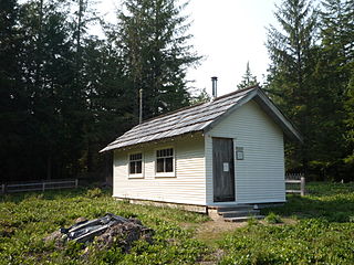
The Peter Roose Homestead is a historic homestead that was settled by Peter Roose, an immigrant from Bollnäs, Sweden, in 1907. Located in Olympic National Park, the site was added as a historic district to the National Register of Historic Places in 2007.
Elk is an unincorporated community in Noble County, in the U.S. state of Ohio.
Belfort is an unincorporated community in Stark County, in the U.S. state of Ohio.


