Deacon is an unincorporated community in Deer Creek Township, Cass County, Indiana.

Camp Klamath is an unincorporated community in Del Norte County, California. It is located on the east bank of the Klamath River 1.5 miles (2.4 km) from its mouth, at an elevation of 23 feet.

Khoonkhwuttunne is a former Tolowa settlement in Del Norte County, California, located at the mouth of the Smith River. It lay at an elevation of 33 feet.

Waukell Flat is a former settlement in Del Norte County, California. It was located on the south bank of the Klamath River 4.25 miles (6.8 km) from its mouth, at an elevation of 23 feet. It still appeared on maps as of 1952.

Elk Grove is a former settlement in Humboldt County, California. It was located 6 miles (9.7 km) north-northeast of Orick, at an elevation of 151 feet. It still appeared on maps as of 1947.
Eshpeu is a former Yurok settlement in Humboldt County, California. It was located at Gold Bluff between the mouths of the Klamath River and Redwood Creek. Espa Lagoon is near the site of Eshpeu.

Moonstone is an unincorporated community in Humboldt County, California. It is located 2.5 miles (4.0 km) southeast of Trinidad, at an elevation of 121 feet. For census purposes, it is aggregated in Westhaven-Moonstone, California. The area is sited adjacent to Pacific Ocean beach and the mouth of the Little River with views of the rugged coastline.

Ore'q is a former Yurok settlement in Humboldt County, California. It lay at an elevation of 30 feet. The town of Orick, California keeps the name alive in nearly the same place today.

Patricks Point is an unincorporated community in Humboldt County, California. It is located 4.5 miles (7.2 km) north of Trinidad, at an elevation of 239 feet.

Shumig is a former Yurok settlement in Humboldt County, California. It was located at Patrick's Point, at an elevation of 236 feet.

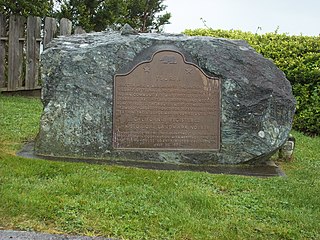
Tsurai is a former Yurok settlement in Humboldt County, California. It was located at Trinidad, at an elevation of 174 feet and is California State Historic Landmark #838.

Westhaven is an unincorporated community in Humboldt County, California. It is located 2.5 miles (4 km) southeast of Trinidad, at an elevation of 328 feet. For census purposes it is amalgamated into Westhaven-Moonstone. The ZIP Code is 95570.
Sonans is an unincorporated community in Pittsylvania County, in the U.S. state of Virginia.
Port Haywood is an unincorporated community in Mathews County, in the U. S. state of Virginia.
Centerville is an unincorporated community in Wayne County, in the U.S. state of Ohio.
East Fork of West Fork Mojave River is a tributary stream of the West Fork Mojave River, itself a tributary of the Mojave River, in the San Bernardino Mountains of San Bernardino County, California. Its mouth originally was at its confluence with the West Fork Mojave River which is now submerged under Lake Silverwood. It now lies at an elevation of 3,376 feet / 1,029 meters at its confluence with that lake. The source of the East Fork is at 34°15′11″N117°14′24″W at an elevation of 5,500 feet in Twin Peaks, California.
Aid is an unincorporated community in Stoddard County, in the U.S. state of Missouri.
El Camino is an unincorporated community in Tehama County, in the U.S. state of California.
Antioch is an unincorporated community in Jackson Parish, Louisiana, United States.


