
Ferndale is a city in Oakland County in the U.S. state of Michigan. It forms part of the Detroit metropolitan area. As of the 2010 census, the city population was 19,900. Ferndale is well known in the Detroit area for its LGBT population and progressive policies.

Ferndale is a city in Humboldt County, California, United States. Its population was 1,371 at the 2010 census, down from 1,382 at the 2000 census. The city contains dozens of well-preserved Victorian storefronts and homes. Ferndale is the northern gateway to California's Lost Coast and the city, which is sited on the edge of a wide plain near the mouth of the Eel River, is also located near the extensive preserves of Coast Redwood forests.

Ferndale is a city in Whatcom County, Washington, United States. The population was 11,415 at the 2010 census. It is the third largest city in Whatcom County and borders the Lummi Nation on its southern border.
Ferndale is the name of several places:

Ferndale is a small town located in the Rhondda Valley in the county borough of Rhondda Cynon Taf, Wales. Neighbouring villages are Blaenllechau, Maerdy and Tylorstown. Ferndale was industrialised in the mid-19th century. The first coal mine shaft was sunk in 1857 and was the first community to be intensively industrialised in the Rhondda Valley.
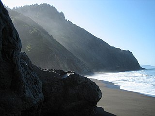
The Lost Coast is a mostly natural and undeveloped area of the California North Coast in Humboldt and Mendocino Counties, which includes the King Range. It was named the "Lost Coast" after the area experienced depopulation in the 1930s. In addition, the steepness and related geotechnical challenges of the coastal mountains made this stretch of coastline too costly for state highway or county road builders to establish routes through the area, leaving it the most undeveloped and remote portion of the California coast. Without any major highways, communities in the Lost Coast region such as Petrolia, Shelter Cove, and Whitethorn are isolated from the rest of California.

Honeydew is an unincorporated community in Humboldt County, California. It is located 17 miles (27 km) south of Scotia, at an elevation of 322 feet, 15 miles (24 km) from the Pacific Ocean in the Lost Coast, near the King Range. It has a general store, elementary school, post office, and a few houses nearby. Many of the locals live in the hills surrounding the Mattole valley, named after the Mattole River which runs through the valley. The ZIP code is 95545 and the community is inside area code 707.

Cape Mendocino Light was a navigation light at Cape Mendocino, California. The former lighthouse was relocated to Shelter Cove near Point Delgada, California in 1998, and the historic Fresnel lens to Ferndale, California, in 1948. An automated beacon operated for a number of years but was removed in May 2013.

Donald Holst "Don" Clausen is a former U.S. Representative from California.
Fernbridge is an unincorporated community at an elevation of 39 feet (12 m) in Humboldt County, California, named for a historic bridge, 3 miles (4.8 km) west-northwest of Fortuna.
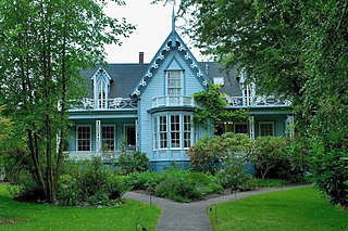
The Shaw House, also known as the Shaw House Inn, is a historic Carpenter Gothic Victorian style house located at 703 Main Street in Ferndale, Humboldt County, California. It served historically as a courthouse, a post office, and a single-family dwelling.

Centerville is a former settlement in Humboldt County, California. It was located 4.5 miles (7 km) west of Ferndale, on the Pacific Ocean at an elevation of 13 feet.

Port Kenyon is an unincorporated community in Humboldt County, California. It is located 1.5 miles (2.4 km) northwest of Ferndale, at an elevation of 13 feet.

Meridian is a former settlement in Humboldt County, California. It was located 1 mile (1.6 km) west of Ferndale.
Ferndale High School is the name of several high schools in the United States:

The Alford–Nielson Home, is the only example of Second Empire French Victorian Architecture in Ferndale, Humboldt County, California.

The Ferndale Museum, located in Ferndale, California, houses and exhibits artifacts, documents and papers from settlement during the California Gold Rush to the present including an active Bosch-Omori seismograph. The area of collection covers the lower Eel River Valley as far south as the Mattole River Valley and west to the Pacific Ocean. Collections include over 6,000 photographs, back issues of the Ferndale Enterprise newspaper, and family papers spanning 140 years.

The Ferndale Public Library was built in 1909 as Carnegie Grant Library on donated land and supported by the city of Ferndale, California, until becoming part of the Humboldt County Library system in 1915. It is the only Carnegie Library in northwestern California still functioning as a Public Library.

The Salt River is a formerly navigable hanging channel of the Eel River which flowed about 9 miles (14 km) from near Fortuna and Waddington, California, to the estuary at the Pacific Ocean, until siltation from logging and agricultural practices essentially closed the channel. It was historically an important navigation route until the early 20th century. It presently intercepts and drains tributaries from the Wildcat Hills along the south side of the Eel River floodplain. Efforts to restore the river began in 1987, permits and construction began in 2012, and water first flowed in the restored channel in October 2013.
The Ferndale Unified School District, oversees public education through grade 12, in Ferndale, California, and the surrounding area, including the "Ferndale bottoms" and an area of the Wildcat Hills in Humboldt County, California.


