
Cuautla, Jalisco is a small town located in the hills of western Mexico. It is situated at an elevation of 5,639 ft. between Guadalajara and Puerto Vallarta. It has fewer than 3,000 permanent residents.

Spring Creek is an unincorporated community in El Dorado County, California. It lies at an elevation of 6339 feet.
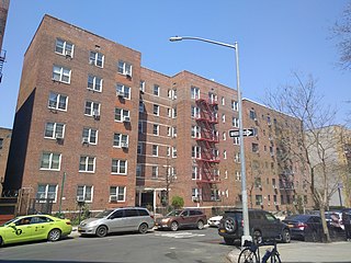
Bogardus Place is located in the Inwood section of New York City borough of Manhattan. The one-block street was opened in 1912, and runs 642 feet (196 m) between Hillside Avenue and Ellwood Street, and is named for the family who previously owned much of the land that forms both Fort Tryon Park, and the Fort Tryon section.

Whitethorn is an unincorporated community in Humboldt County, California. It is located 9.5 miles (15 km) southwest of Garberville, at an elevation of 1024 feet, population 817. Whitethorn shares a zip code with Shelter Cove, California. It is located along California's Lost Coast. The ZIP Code is 95589.
Pepperwood is an unincorporated community in Humboldt County, California. It is located 3.5 miles (5.6 km) northwest of Redcrest, at an elevation of 115 feet. Pepperwood is the northernmost community along the Avenue of the Giants. The ZIP Code is 95569. The community is inside area code 707.
Peaceful Pines is an unincorporated community in Alpine County, California. It lies at an elevation of 6207 feet.

Briceland is an unincorporated community in Humboldt County, California. It is 6 miles (10 km) west of Redway, at an elevation of 594 feet.
Brock Creek is a former settlement in Humboldt County, California. It was located on the Northwestern Pacific Railroad 7.5 miles (12 km) northwest of Alderpoint, at an elevation of 279 feet. It still appeared on maps as of 1949.
Englewood is an unincorporated community in Humboldt County, California. It is located 0.5 miles (0.8 km) east-southeast of Redcrest, at an elevation of 364 feet. The area is the site of a few homes and a derelict Eel River Sawmills mill.
Larabee is a locality in Humboldt County, California. It is located on the Northwestern Pacific Railroad 1 mile (2 km) east-northeast of Redcrest, at an elevation of 161 feet (49 m). Larabee only has seasonal access across the Eel River; alternatively there is a former lumber road through Larabee Ranch, and on through Pacific Lumber Company property, that connects to Shively Road approximately five miles northwest. This road is only open during the winter when the temporary summer bridge is washed away by the rain-engorged Eel River.
Tanoak is a former settlement in Humboldt County, California. It was located on the Northwestern Pacific Railroad 8 miles (13 km) east of Weott, at an elevation of 207 feet. It still appeared on maps as of 1949.
Fuller is an unincorporated community in Imperial County, California. It is located on a former branch of the Southern Pacific Railroad 3.5 miles (5.6 km) north-northwest of Holtville, at an elevation of 69 feet below sea level.
Imperial Gables is an unincorporated community in Imperial County, California. It is located 12.5 miles (20 km) northeast of Glamis, at an elevation of 1283 feet.
Blackrock is an unincorporated community in Inyo County, California. It lies at an elevation of 3829 feet and is located at 36°55′45″N118°14′00″W.
Elk Prairie is a former settlement in Humboldt County, California. It was located 6 miles (9.7 km) southeast of Camp Grant and adjacent to Fruitland, California.

Iaqua is a former settlement in Humboldt County, California. It was located 5.5 miles (8.9 km) south of Kneeland.
Yorkville is an unincorporated community in Mendocino County, California. It is located 7.5 miles (12 km) southwest of Hopland, at an elevation of 922 feet.
There are 21 mountain peaks named West Peak in the United States according to the US Geological Survey Geographic Names Information System.
Horatio is an unincorporated community in Jefferson County, in the U.S. state of Pennsylvania.
Venable is an unincorporated community in northwest Texas County, in the U.S. state of Missouri.


