Blaine, California

Last updated

Blaine is a former settlement in Humboldt County, California. [1] It was located 8 miles (13 km) south of Orick. [1]

Humboldt County, California County in California, United States

Humboldt County is a county in the U.S. state of California. As of the 2010 census, the population was 132,646. The county seat is Eureka.

California State of the United States of America

California is a state in the Pacific Region of the United States. With 39.6 million residents, California is the most populous U.S. state and the third-largest by area. The state capital is Sacramento. The Greater Los Angeles Area and the San Francisco Bay Area are the nation's second and fifth most populous urban regions, with 18.7 million and 8.8 million residents respectively. Los Angeles is California's most populous city, and the country's second most populous, after New York City. California also has the nation's most populous county, Los Angeles County, and its largest county by area, San Bernardino County. The City and County of San Francisco is both the country's second-most densely populated major city after New York City and the fifth-most densely populated county, behind only four of the five New York City boroughs.

Orick, California census-designated place in California, United States

Orick is a census-designated place situated on the banks of the Redwood Creek in Humboldt County, California. It is located 43 miles (69 km) north of Eureka, at an elevation of 26 feet. The population was 357 at the 2010 census.

A post office operated at Blaine from 1893 to 1895. [1] The name honors Secretary of State James Blaine. [1]

Related Research Articles

Pine Hill, California Unincorporated community in California, United States

Pine Hill is an unincorporated community in Humboldt County, California. It is located 2.5 miles (4 km) south of downtown Eureka, at an elevation of 135 feet. The area is now part of unincorporated Eureka.

Fort Jones, Calaveras County, California Unincorporated community in California, United States

Fort Jones is an unincorporated community in Calaveras County, California. It lies at an elevation of 2933 feet.

Camp Klamath, California Unincorporated community in California, United States

Camp Klamath is an unincorporated community in Del Norte County, California. It is located on the east bank of the Klamath River 1.5 miles (2.4 km) from its mouth, at an elevation of 23 feet.

Douglas Park, California Unincorporated community in California, United States

Douglas Park is an unincorporated community in Del Norte County, California. It is located on the south bank of the Smith River 7.5 miles (12 km) east-northeast of Crescent City, at an elevation of 138 feet.

Hoppaw, California Unincorporated community in California, United States

Hoppaw is an unincorporated community in Del Norte County, California. It is located on Hoppaw Creek 3 miles (4.8 km) east-southeast of the mouth of the Klamath River, at an elevation of 36 feet. It appears in the Requa U.S. Geological Survey Map.

Tryon Corner, California Unincorporated community in California, United States

Tryon Corner is an unincorporated community in Del Norte County, California. Located 3.5 miles (5.6 km) west of Smith River, at an elevation of 33 feet.

Waukell Flat, California Former settlement in California, United States

Waukell Flat is a former settlement in Del Norte County, California. It was located on the south bank of the Klamath River 4.25 miles (6.8 km) from its mouth, at an elevation of 23 feet. It still appeared on maps as of 1952.

Crescent Ridge Village, California Unincorporated community in California, United States

Crescent Ridge Village is an unincorporated community in El Dorado County, California. It lies at an elevation of 709 feet.

Waterford Village, California Unincorporated community in California, United States

Waterford Village is an unincorporated community in El Dorado County, California. It lies at an elevation of 669 feet.

Berry Glenn is a locality in Humboldt County, California. It lies at an elevation of 52 feet (16 m).

Elk Grove, Humboldt County, California Former settlement in California, United States

Elk Grove is a former settlement in Humboldt County, California. It was located 6 miles (9.7 km) north-northeast of Orick, at an elevation of 151 feet. It still appeared on maps as of 1947.

Eshpeu is a former Yurok settlement in Humboldt County, California. It was located at Gold Bluff between the mouths of the Klamath River and Redwood Creek. Espa Lagoon is near the site of Eshpeu.

Moonstone, California Unincorporated community in California, United States

Moonstone is an unincorporated community in Humboldt County, California. It is located 2.5 miles (4.0 km) southeast of Trinidad, at an elevation of 121 feet. For census purposes, it is aggregated in Westhaven-Moonstone, California. The area is sited adjacent to Pacific Ocean beach and the mouth of the Little River with views of the rugged coastline.

Patricks Point, California Unincorporated community in California, United States

Patricks Point is an unincorporated community in Humboldt County, California. It is located 4.5 miles (7.2 km) north of Trinidad, at an elevation of 239 feet.

Tsurau, California Former settlement in California, United States

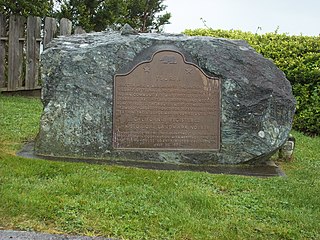
Tsurai is a former Yurok settlement in Humboldt County, California. It was located at Trinidad, at an elevation of 174 feet and is California State Historic Landmark #838.

Westhaven, Humboldt County, California Unincorporated community in California, United States

Westhaven is an unincorporated community in Humboldt County, California. It is located 2.5 miles (4 km) southeast of Trinidad, at an elevation of 328 feet. For census purposes it is amalgamated into Westhaven-Moonstone. The ZIP Code is 95570.

Penny Corner is an unincorporated community in Caroline County, in the U.S. state of Virginia.

Rixey is an unincorporated community in Caroline County, in the U.S. state of Virginia.

Samuels Corner is an unincorporated community in Caroline County, in the U.S. state of Virginia.

References

  1. 1 2 3 4 Durham, David L. (1998). California's Geographic Names: A Gazetteer of Historic and Modern Names of the State. Clovis, Calif.: Word Dancer Press. p. 117. ISBN   1-884995-14-4.

Coordinates: 41°15′27″N124°4′44″W / 41.25750°N 124.07889°W / 41.25750; -124.07889

Geographic coordinate system Coordinate system

A geographic coordinate system is a coordinate system that enables every location on Earth to be specified by a set of numbers, letters or symbols. The coordinates are often chosen such that one of the numbers represents a vertical position and two or three of the numbers represent a horizontal position; alternatively, a geographic position may be expressed in a combined three-dimensional Cartesian vector. A common choice of coordinates is latitude, longitude and elevation. To specify a location on a plane requires a map projection.