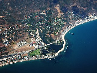
Malibu is a beach city in western Los Angeles County, California, situated about 30 miles (48 km) west of Downtown Los Angeles. It is known for its Mediterranean climate and its 21-mile (34 km) strip of the Malibu coast, incorporated in 1991 into the City of Malibu. The area is known for being the home of Hollywood movie stars, people in the entertainment industry, and other affluent residents. Most Malibu residents live within a few hundred yards of Pacific Coast Highway, which traverses the city, with some residents living up to a mile away from the beach up narrow canyons. As of the 2010 census, the city population was 12,645.

Idyllwild, Pine Cove, and Fern Valley are three adjacent unincorporated communities, of which Idyllwild is the largest, located in the San Jacinto Mountains in Riverside County, California, United States. The Idyllwild community also generally includes the hamlets of Mountain Center and Garner Valley, though individual residents embrace this association to varying degrees. "Mile-high Idyllwild" is a popular southern California mountain resort about one mile (1.6 km) in altitude. Idyllwild is flanked by two large and one smaller rock formation, Tahquitz Peak and Suicide Rock, which are famous in Southern California rock climbing circles, and Mt Atlas. One of Idyllwild's attractions is that it offers all four seasons, yet in winter is only an hour's drive down to the desert on the Pines to Palms Scenic Byway. It currently offers no skiing; thus "the Hill" has been minimally developed over the years and remains a center for hiking, mountain and rock climbing, mountain biking, and horseback riding.

Sylva is an incorporated town located in central Jackson County, in the Plott Balsam Mountains of Western North Carolina, United States of America. As of the 2010 census, the town had a total population of 2,588. It is the county seat, having taken over from nearby Webster in 1913.

Great Smoky Mountains National Park is an American national park and a UNESCO World Heritage Site that straddles the ridgeline of the Great Smoky Mountains, part of the Blue Ridge Mountains, which are a division of the larger Appalachian Mountain chain. The border between Tennessee and North Carolina runs northeast to southwest through the centerline of the park. Great Smoky Mountains is the most visited national park in the United States with over 11.3 million recreational visitors in 2016. The Appalachian Trail passes through the center of the park on its route from Maine to Georgia. The park was chartered by the United States Congress in 1934 and officially dedicated by President Franklin D. Roosevelt in 1940.

The Lane Cove River, a northern tributary of the Parramatta River, is a tide-dominated, drowned valley estuary west of Sydney Harbour, located in Sydney, New South Wales, Australia. The river is a tributary of the Parramatta River, winding through a bushland valley. It joins Parramatta River at Greenwich and Woolwich, where together they form an arm of Sydney Harbour.

The Regional District of Central Okanagan (RDCO) is a regional district in the Canadian province of British Columbia, comprising the City of Kelowna, City of West Kelowna and their surrounding municipalities. The regional district's offices are located in Kelowna.

East Ryde is a suburb in the Northern Suburbs of Sydney, in the state of New South Wales, Australia. East Ryde is located 12 kilometers north-west of the Sydney central business district, in the local government area of the City of Ryde. East Ryde sits on the western bank of the Lane Cove River. East Ryde shares the postcode of 2113 with adjacent suburb of North Ryde though it does not have a Post Office of its own.
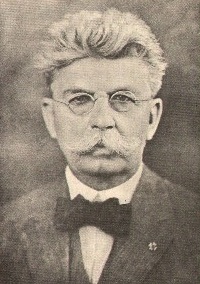
Francis Marion Smith was an American miner, business magnate and civic builder in the Mojave Desert, the San Francisco Bay Area, and Oakland, California.
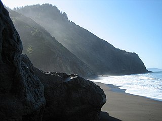
The Lost Coast is a mostly natural and undeveloped area of the California North Coast in Humboldt and Mendocino Counties, which includes the King Range. It was named the "Lost Coast" after the area experienced depopulation in the 1930s. In addition, the steepness and related geotechnical challenges of the coastal mountains made this stretch of coastline too costly for state highway or county road builders to establish routes through the area, leaving it the most undeveloped and remote portion of the California coast. Without any major highways, communities in the Lost Coast region such as Petrolia, Shelter Cove, and Whitethorn are isolated from the rest of California.

McKee is a light rail station operated by Santa Clara Valley Transportation Authority (VTA). This station is served by VTA's Alum Rock–Santa Teresa line.

Pennsylvania Route 16 is a 43-mile-long (69 km) east–west state route located in southern Pennsylvania, United States. The western terminus of the route is at U.S. Route 522 in McConnellsburg. The eastern terminus is at the Mason–Dixon line in Liberty Township, where the road continues into Maryland as Maryland Route 140. PA 16 is a two-lane road that runs through rural areas in Fulton, Franklin, and Adams counties. The route heads east from McConnellsburg and crosses Tuscarora Mountain into Franklin County, where it continues east into the agricultural Cumberland Valley. Here, the passes through Mercersburg, Greencastle, and Waynesboro. PA 16 heads east through the South Mountain range, where it heads into Adams County and passes through Carroll Valley before coming to the Maryland border. PA 16 intersects several roads including PA 456 in Cove Gap, PA 75 and PA 416 in Mercersburg, PA 995 in Upton, US 11 and Interstate 81 (I-81) in Greencastle, PA 316 and PA 997 in Waynesboro, and PA 116 in Carroll Valley. The road's main name is Buchanan Trail in honor of former President James Buchanan, who was born near the road in Cove Gap.
Morrisons Cove, is an eroded anticlinal valley in Blair and Bedford counties of central Pennsylvania, United States, extending from Evitts Mountain near New Enterprise, north to the Frankstown Branch Juniata River at Williamsburg. The width of the valley varies from 10 to 15 miles between Tussey Mountain on the east to the chain of Dunning, Loop and Lock Mountains on the west. Almost entirely enclosed by these mountains, the only openings in the cove are at Loysburg Gap in the south, McKee Gap in the west, and at Williamsburg to the north. The floor of the valley is mostly level, with many large fertile farm fields. The southern end of the valley drains to the Raystown Branch Juniata River via Yellow Creek through Loysburg Gap, and the northern end drains to the Frankstown Branch, via Clover Creek.

Spence Field is a mountain highland meadow in the Great Smoky Mountains, located in the Southeastern United States. It has an elevation of 4,920 feet above sea level. The Appalachian Trail traverses the field, and a backcountry shelter just off the trail provides an overnight stopover for through-hikers.

Cove Lake State Park is a state park in Campbell County, Tennessee, in the southeastern United States. The park consists of 673 acres (2.72 km2) situated around Cove Lake, an impoundment of Cove Creek created by the completion of Caryville Dam in 1936. The park's location is adjacent to the town of Caryville and just west of Jacksboro.

Whitethorn is an unincorporated community in Humboldt County, California. It is located 9.5 miles (15 km) southwest of Garberville, at an elevation of 1024 feet, population 817. Whitethorn shares a zip code with Shelter Cove, California. It is located along California's Lost Coast. The ZIP Code is 95589.

Little Greenbrier is the name of a former Appalachian community that is now an historical area in the Great Smoky Mountains of East Tennessee. The community was situated in a hollow rising from Metcalf Bottoms along Little River to the upper slopes of Cove Mountain, in the northeastern section of the national park. Little Greenbrier was once known simply as "Greenbrier," but the "Little" was added to its name to distinguish it from the larger Greenbrier located between Mount Le Conte and Mount Guyot to the east.
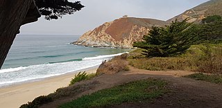
Gray Whale Cove State Beach is a California State Park between Pacifica, California, and Montara, California, by Highway 1 and approximately 18 miles south of San Francisco. It features a sheltered cove surrounded by abrupt cliffs, with trails connecting to nearby Montara Mountain and McNee Ranch State Park. It is located just south of Devil's Slide. The 3.1-acre (1.3 ha) park was established in 1966.

Dunning Mountain is a stratigraphic ridge in central Pennsylvania, United States. The mountain's north end is at McKee Gap, which separates it from Short Mountain, and where Halter Creek flows westward towards the Frankstown Branch of the Juniata River. The south end of the mountain is contiguous with Evitts Mountain, but is marked by a sharp bend to the east. The valley formed by the bend is known as "The Kettle," and the broad valley to the east of Dunning Mountain is called Morrisons Cove. The town of Roaring Spring is located at the north end of the mountain on the east side.

Cove Mountain is a wildland in the George Washington and Jefferson National Forests of western Virginia that has been recognized by the Wilderness Society as a special place worthy of protection from logging and road construction.


