California State Route 211

Last updated

California 211.svg
State Route 211
California State Route 211 Map.svg
Map of Humboldt County in northwestern California with SR 211 highlighted in red
Route information
Maintained by Caltrans
Length5.395 mi [1]  (8.682 km)
Major junctions
South endOcean Avenue in Ferndale
North endUS 101 (1961 cutout).svg US 101 at Fernbridge
Location
Country United States
State California
Counties Humboldt
Highway system
California 210.svg SR 210 California 213.svg SR 213

State Route 211 (SR 211) is a state highway in the U.S. state of California that connects Ferndale with U.S. 101 in Humboldt County. The highway was originally designed to be the northernmost segment of State Route 1, but after construction of the Coast Highway through the Lost Coast region was abandoned, the route to Ferndale was renumbered to SR 211.
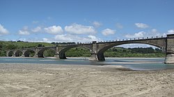
Contents

Route description

State Route 211 crossing the Eel River Fernbridge.JPG
State Route 211 crossing the Eel River
State Route 211 looking north from the city limits of Ferndale, California California State Route 211.jpg
State Route 211 looking north from the city limits of Ferndale, California

Currently, Route 211 runs about 5 miles (8 km) from roughly the intersection of Main Street and Ocean Avenue in Ferndale north to US 101 in Fernbridge, crossing over the bridge of the same name over the Eel River. However, the highway was meant to extend south through the Lost Coast region to California State Route 1 near Rockport. This remaining 103 mi (166 km) of Highway 211 is unlikely ever to be constructed because of the steep and unstable highlands of the Lost Coast. The traversable route through Humboldt and Mendocino Counties is Chemise Mountain Road, Wilder Ridge Road, and Mattole Road, but these remain small mountain roads.

SR 211 is part of the California Freeway and Expressway System, [2] but is not part of the National Highway System, [3] a network of highways that are considered essential to the country's economy, defense, and mobility by the Federal Highway Administration. [4]

History

This route was originally signed as the northernmost segment of California State Route 1, but was renumbered as SR 211 in 1984 after construction through the Lost Coast was abandoned; the portion of Highway 1 north of Rockport was then re-routed along the former State Route 208 to terminate with US 101 in Leggett. [5]

Major intersections

Except where prefixed with a letter, postmiles were measured on the road as it was when the route was established, based on the alignment that existed at the time, and do not necessarily reflect current mileage. R reflects a realignment in the route since then, M indicates a second realignment, L refers to an overlap due to a correction or change, and T indicates postmiles classified as temporary (for a full list of prefixes, see California postmile § Official postmile definitions ). [1] Segments that remain unconstructed or have been relinquished to local control may be omitted. The entire route is in Humboldt County.

LocationPostmile
[1] [6] [7]
DestinationsNotes
Ferndale 73.20Ocean Avenue – Petrolia South end of SR 211; road continues as Francis Street
R74.19Van Ness Avenue
R75.78Coffee Creek Road, Sage Road
R76.69Goble Lane
78.10 Fernbridge over the Eel River
Fernbridge 78.59Fernbridge Drive – Fortuna Connects to US 101 south
79.16US 101 (1961 cutout).svg US 101  Eureka, Fortuna Interchange; north end of SR 211; US 101 exit 692
1.000 mi = 1.609 km; 1.000 km = 0.621 mi

See also

Related Research Articles

<span class="mw-page-title-main">California State Route 1</span> State highway in California, United States

State Route 1 (SR 1) is a major north–south state highway that runs along most of the Pacific coastline of the U.S. state of California. At 656 miles (1,056 km), it is the longest state route in California, and the second-longest in the US after Montana Highway 200. SR 1 has several portions designated as either Pacific Coast Highway (PCH), Cabrillo Highway, Shoreline Highway, or Coast Highway. Its southern terminus is at Interstate 5 (I-5) near Dana Point in Orange County and its northern terminus is at U.S. Route 101 (US 101) near Leggett in Mendocino County. SR 1 also at times runs concurrently with US 101, most notably through a 54-mile (87 km) stretch in Ventura and Santa Barbara counties, and across the Golden Gate Bridge.

<span class="mw-page-title-main">Avenue of the Giants</span> Highway in California

The Avenue of the Giants is a scenic highway in northern California, United States, running through Humboldt Redwoods State Park. It is named for the coast redwoods that tower over the route. The road is a former alignment of U.S. Route 101, and continues to be maintained as a state highway as State Route 254.

<span class="mw-page-title-main">California State Route 116</span> Highway in California

State Route 116 (SR 116) is a state highway in the U.S. state of California in Sonoma County. The route runs from SR 1 on the Pacific coast near Jenner to SR 121 south of Sonoma.

<span class="mw-page-title-main">California State Route 154</span> Highway in California

State Route 154 is a state highway in the U.S. state of California that runs from Los Olivos to Santa Barbara, crossing the San Marcos Pass in the Santa Ynez Mountains. Before U.S. Route 101 was built through the Gaviota Pass, SR 154 was the main throughway to Santa Barbara and the tri city area including use as a stagecoach route in early years. After being replaced by US 101 as the primary route between the Santa Ynez Valley and Santa Barbara, SR 154 now serves as a scenic bypass.

<span class="mw-page-title-main">California State Route 283</span> Highway in California

U.S. Route 101 Business is a business loop of U.S. Route 101 that runs along Wildwood Avenue in Rio Dell in Humboldt County, California. Its southernmost section between US 101 near Scotia to the north end of the Eel River Bridge is legally defined as an unsigned state highway, State Route 283. The route was defined in 1970 as a transfer from a realigned US 101 after a freeway bypass was built.

<span class="mw-page-title-main">California State Route 12</span> State highway in California, United States

State Route 12 is a state highway in the U.S. state of California that travels in an east–west direction from State Route 116 in Sebastopol in Sonoma County to State Route 49 just north of San Andreas in Calaveras County. The route connects the Sonoma and Napa valleys with the Sacramento–San Joaquin River Delta and the Sierra Foothills. It is constructed to freeway standards from the Fulton Road/South Wright Road stoplight in Santa Rosa, to its partial interchange with Farmers Lane.

<span class="mw-page-title-main">California State Route 33</span> Highway in California

State Route 33 is a north–south state highway in the U.S. state of California. It runs north from U.S. Route 101 in Ventura through the Transverse Ranges and the western side of the San Joaquin Valley to Interstate 5 at a point east of Tracy. SR 33 replaced part of U.S. Route 399 in 1964 during the "great renumbering" of routes. In the unincorporated sections of Kern County it is known as the West Side Highway. In addition, the California Legislature designated the entire Kern County portion as the Petroleum Highway in 2004. The southernmost portion in Ventura is a freeway known as the Ojai Freeway, while it is known as the Maricopa Highway from Ojai to Maricopa.

<span class="mw-page-title-main">California State Route 232</span> Highway in California

State Route 232 is a state highway in the U.S. state of California that runs along Vineyard Avenue in Ventura County, serving as a connector between US 101 in Oxnard and SR 118 near Saticoy.

<span class="mw-page-title-main">Topanga Canyon Boulevard</span> Highway in California

State Route 27, commonly known by its street name Topanga Canyon Boulevard, is a state highway in the U.S. state of California that runs from the Pacific Coast Highway at Topanga State Beach near Pacific Palisades, through the Topanga Canyon in Topanga, and continuing through Woodland Hills, Canoga Park, West Hills, and Chatsworth to the Ronald Reagan Freeway.

<span class="mw-page-title-main">California State Route 246</span> Highway in California

State Route 246 is a state highway in the U.S. state of California that runs from Lompoc east to Solvang and Santa Ynez, cutting through the Santa Ynez Valley and the Santa Barbara Wine Country. Its western terminus is at the western city limits of Lompoc, and its eastern terminus is at State Route 154 near Santa Ynez.

<span class="mw-page-title-main">California State Route 32</span> Highway in California

State Route 32 is an east–west state highway in the U.S. State of California which is routed from Interstate 5 in Orland, across the Sacramento Valley and through Chico, through the northern Sierra Nevada, and ending at SR 36 and SR 89 in eastern Tehama County.

<span class="mw-page-title-main">California State Route 36</span> Highway in California

State Route 36 is an east–west state highway in the U.S. state of California that is routed from U.S. Route 101 in Humboldt County to U.S. Route 395 just east of Susanville in Lassen County. The highway passes through Red Bluff, the county seat of Tehama County, on the northern edge of the Sacramento Valley. The portion of SR 36 travelling past Lassen Volcanic National Park and Lake Almanor is part of the Volcanic Legacy Scenic Byway, a National Scenic Byway. Also, Route 36 between Alton and Susanville is a designated Blue Star Memorial Highway.

<span class="mw-page-title-main">California State Route 128</span> Highway in California from the Mendocino coast to the Sacramento Valley

State Route 128 is a state highway in the U.S. state of California, connecting the Mendocino coast to the Sacramento Valley, through the state's Wine Country. It runs from State Route 1 near Albion to Interstate 505 in Winters.

<span class="mw-page-title-main">California State Route 229</span> Highway in California

State Route 229 is a state highway in the U.S. state of California, running in San Luis Obispo County from State Route 58 to State Route 41. It connects the small community of Creston with the rural state routes. Also, in conjunction with SR 58 and SR 41, it provides a slower, more scenic route between the Central Coast and the San Joaquin Valley.

<span class="mw-page-title-main">California State Route 253</span> Highway in Mendocino County, California

State Route 253, also known as the Ukiah–Boonville Road, is a state highway in the U.S. state of California that runs between the Anderson and Ukiah valleys in Mendocino County. It crosses the mountains of the Mendocino Range from State Route 128 near Boonville to U.S. Route 101 near Ukiah.

<span class="mw-page-title-main">California State Route 169</span> Highway in California

State Route 169 is a state highway in the U.S. state of California that is separated into two distinct segments by undeveloped areas in the Yurok Indian Reservation in Del Norte and Humboldt counties. The western segment runs from U.S. Route 101 near Klamath to Klamath Glen, while the eastern segment goes from Wautec Village to State Route 96 near Weitchpec.

<span class="mw-page-title-main">California State Route 175</span> Highway in California

State Route 175 is a state highway in the U.S. state of California that runs through the Mayacamas Mountains, connecting U.S. Route 101 in Hopland in Mendocino County with State Route 29 in Middletown in Lake County.

<span class="mw-page-title-main">California State Route 200</span> State highway in Humboldt County, California, United States

State Route 200 is a state highway in the U.S. state of California near Arcata in Humboldt County. It is a cut-off connecting U.S. Route 101 and State Route 299. It runs along the north bank of the Mad River, to the north of the 101-299 junction. It is also known as North Bank Road.

<span class="mw-page-title-main">California State Route 255</span> Highway in California

State Route 255 is a state highway in the U.S. state of California. It is a loop route of U.S. Route 101 in Humboldt County that runs through the Samoa Peninsula on the western side of Humboldt Bay.

<span class="mw-page-title-main">California State Route 271</span> State highway in Humboldt and Mendocino Counties, California, United States

State Route 271 is a state highway in the U.S. state of California that runs along a former routing of U.S. Route 101 in Mendocino and Humboldt counties. It also connects with State Route 1 just before that route's terminus with US 101 in Leggett. After US 101 was realigned, SR 271 was reduced to being a frontage road in discontinuous segments. While US 101 stays mostly in second growth redwoods, SR 271 is used as a scenic alternate through several old growth redwood groves.

References

  1. 1 2 3 California Department of Transportation. "State Truck Route List". Sacramento: California Department of Transportation. Archived from the original (XLS file) on September 5, 2015. Retrieved June 30, 2015.
  2. "Article 2 of Chapter 2 of Division 1". California Streets and Highways Code. Sacramento: California Office of Legislative Counsel. Retrieved February 6, 2019.
  3. Federal Highway Administration (March 25, 2015). National Highway System: California (North) (PDF) (Map). Scale not given. Washington, DC: Federal Highway Administration. Retrieved September 14, 2017.
  4. Natzke, Stefan; Neathery, Mike & Adderly, Kevin (June 20, 2012). "What is the National Highway System?". National Highway System. Washington, DC: Federal Highway Administration. Retrieved July 1, 2012.
  5. California State Assembly. "An act...relating to state highways". 1983–1984 Session of the Legislature. Statutes of California. State of California. Ch. 409. Route 1 is from ... to US 101 near Leggett ... Section 508 of the Street and Highway Code [defining Route 208] is repealed ... Route 211 is from Route 1 near Rockport to Route 101 near Fernbridge.
  6. California Department of Transportation (July 2007). "Log of Bridges on State Highways". Sacramento: California Department of Transportation.
  7. California Department of Transportation, All Traffic Volumes on CSHS, 2005 and 2006
Template:Attached KML/California State Route 211
KML is from Wikidata