
Van Nuys is a neighborhood in the central San Fernando Valley region of Los Angeles, California. Home to Van Nuys Airport and the Valley Municipal Building, it is the most populous neighborhood in the San Fernando Valley.
Sunset Boulevard is a boulevard in the central and western part of Los Angeles, California, United States, that stretches from the Pacific Coast Highway in Pacific Palisades east to Figueroa Street in Downtown Los Angeles. It is a major thoroughfare in the cities of Beverly Hills and West Hollywood, as well as several districts in Los Angeles.

Brentwood is a suburban neighborhood in the Westside region of Los Angeles.
Bel Air is a residential neighborhood on the Los Angeles Westside, in the foothills of the Santa Monica Mountains in the U.S. state of California. Founded in 1923, it is the home of the Hannah Carter Japanese Garden and the American Jewish University.
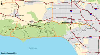
Mulholland Drive is a street and road in the eastern Santa Monica Mountains of Southern California. It is named after pioneering Los Angeles civil engineer William Mulholland. The western rural portion in Los Angeles and Ventura Counties is named Mulholland Highway. The road is featured in a significant number of films, songs, and novels. David Lynch, who wrote and directed a film named after Mulholland Drive, has said that one can feel "the history of Hollywood" on it. Jack Nicholson has lived on Mulholland Drive for many years, and still did so as of 2009.
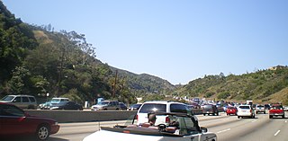
Interstate 405 is a major north–south auxiliary Interstate Highway in Southern California. The entire route is known as the northern segment of the San Diego Freeway. I-405 is a bypass auxiliary route of I-5, running along the southern and western parts of the Greater Los Angeles urban area from Irvine in the south to Sylmar in the north.
The Los Angeles Westside is an urban region in western Los Angeles County, California, United States. It has no official definition, but sources like LA Weekly and the Mapping L.A. survey of the Los Angeles Times place the region on the western side of the Los Angeles Basin south of the Santa Monica Mountains.
North Hills, known previously as Sepulveda, is a neighborhood in the San Fernando Valley region of Los Angeles, California.
West Los Angeles is an area within the city of Los Angeles, California, United States. The residential and commercial neighborhood is divided by the Interstate 405 freeway, and each side is sometimes treated as a distinct neighborhood, mapped differently by different sources. Each lies within the larger Westside region of Los Angeles County.

Rancho Park is a residential neighborhood in the Westside of the city of Los Angeles, California with mostly single family homes and tree lined streets. The community is nestled between West Los Angeles and Cheviot Hills. This enclave draws young professionals and families and is home to residents working in a variety of professional occupations. History proves the neighborhood was once a part of Westwood until Olympic Blvd. was placed dividing the area North and South. The Southern section, now known as Rancho Park, felt cut off from its North side lobbying for its own identity in the 1930s.

Colorado Boulevard is a major east–west street in Southern California. It runs from Griffith Park in Los Angeles east through Glendale, the Eagle Rock section of Los Angeles, Pasadena, and Arcadia, ending in Monrovia. The full route was once various state highways but is now locally maintained in favor of the parallel Ventura Freeway and Foothill Freeway (I-210).
Sepulveda Pass is a low mountain pass through the Santa Monica Mountains in Los Angeles. It is named after the Sepúlveda family of California, a prominent Californio family that owned the land where the pass lies.

East Hollywood is a densely populated neighborhood of 78,000+ residents that is part of the Hollywood area of the central region of Los Angeles, California. It is notable for being the site of Los Angeles City College, Barnsdall Park, and a hospital district. There are seven public and five private schools, a Los Angeles Public Library branch, and three hospitals. Almost two-thirds of the people living there were born outside the United States, and 90% were renters. In 2000, the neighborhood had high percentages of never-married people and single parents.

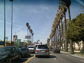
Sepulveda Boulevard is a major street and transportation corridor in the City of Los Angeles and several other cities in western Los Angeles County, California. The street parallels Interstate 405 for much of its route. Portions of Sepulveda Boulevard between Manhattan Beach and Los Angeles International Airport (LAX) are designated as part of State Route 1.
Lake Balboa is a neighborhood in the San Fernando Valley region of Los Angeles, California. The area was previously part of Van Nuys.

Beverly Glen Boulevard is one of five major routes that connect the Westside of Los Angeles to the San Fernando Valley (the other four are the San Diego Freeway, Sepulveda Boulevard, Laurel Canyon Boulevard, and Coldwater Canyon Avenue.

Mandeville Canyon is a small community in the Brentwood neighborhood of Los Angeles. Its center is Mandeville Canyon Road, which begins at Sunset Boulevard and extends north towards Mulholland Drive, though it stops short of Mulholland and there is no automotive route between the two. Mandeville Canyon Road is said to be the longest paved, dead end road in Los Angeles, at over 5 miles (8.0 km) and as a result is a popular destination for road cycling. From start to finish, the road gains 1,000 ft (300 m) in elevation.
Brentwood Circle is a small neighborhood within the larger neighborhood of Brentwood on the Westside of Los Angeles.

University Park is a 1.17 square miles (3.0 km2) neighborhood in the South Los Angeles region of Los Angeles, California. It is the home of the University of Southern California (USC), Mount St. Mary's College and Hebrew Union College. Additionally, the neighborhood is the home of the historic Shrine Auditorium.
Victory Boulevard is a major east–west arterial road that runs for 25 miles (40 km) traversing the entire length of the San Fernando Valley in Los Angeles County, Southern California, United States.
