Playa Vista, Los Angeles

Last updated
Playa Vista
Bluff Creek and Playa Vista.jpg
Playa Vista from the south, with Bluff Creek in foreground
Playa Vista neighborhood of Los Angeles, California.png
Playa Vista neighborhood as mapped by the Los Angeles Times
Location map Western Los Angeles.png
Red pog.svg
Playa Vista
Location within Western Los Angeles
Coordinates: 33°58′44″N118°24′53″W / 33.97889°N 118.41472°W / 33.97889; -118.41472
CountryUnited States
State California
County Los Angeles
City Los Angeles
ZIP Code
90094

Playa Vista is a neighborhood in the Westside area of Los Angeles, California, United States. The area was the headquarters of Hughes Aircraft Company from 1941 to 1985 and the site of the construction of the Hughes H-4 Hercules "Spruce Goose" aircraft. [1] The area began development in 2002 as a planned community with residential, commercial, and retail components. [2] [3] [4] The community attracted businesses in technology, media and entertainment and is part of Silicon Beach. [5]

Contents

History

Tongva Native Americans

The Tongva inhabited the location now occupied by Playa Vista at the village of Guashna. [6] A Tongva sacred burial site is located here: "about 1,000 Native American remains [...] had been exhumed during construction," grave sites that were deemed sacred by the Tongva people. [7] The remains were discovered after construction began. [6] [8] In 2008, the remains "were laid to rest and covered with white seashells during a sacred burial ceremony near the Westchester bluffs." [6] Playa Vista planned a museum to educate people about the Ballona wetlands and the Gabrieliño-Tongva tribe. [6] The Westchester/Playa Vista Discovery Center opened in 2020, which features a small monument. [9]

Port Ballona

In 1839 the land was part of Rancho La Ballona, later in 1887, it became part of the Port Ballona. [10] [11]

Ballona Creek Watershed

Prior to its development as headquarters for Hughes Aircraft Company, much of the land occupied by Playa Vista was a wetlands connected with a large salt-marsh in what is now Marina Del Rey. These wetlands were formerly part of the larger Ballona Creek watershed that occupied these areas along with what is now Playa Del Rey, and much of Venice, Los Angeles. [12]

Howard Hughes - Spruce Goose

In the 1940s, the aviator Howard Hughes bought the site and constructed a private airfield runway, named Hughes Airport, and an aircraft factory with large hangars for his Hughes Aircraft Company production. The famous Spruce Goose (Hughes H-4 Hercules plane), with the largest wingspan and height of any aircraft in history, was built in the hangar and then transported to Long Beach Harbor for its only flight in 1947.

Development

Prior efforts

During the late 1990s, DreamWorks failed in its attempt to build a studio in Playa Vista. [13] [14]

New project

Phase One of Playa Vista began in 2001 as "a mix of affordable and luxury housing, office and commercial space and open spaces and recreational amenities, all set next to a restored wetlands and wildlife preserve." [15] In October, Steve Soboroff was named president of Playa Vista. [16] [17]

It was one of "six communities in the nation selected by President Bill Clinton in 1998 as a National Pilot Project of the Partnership for Advancing Technology in Housing (PATH)." [15] As such it is, "one of the most technologically advanced communities ever planned" and is "fully connected via telecommunications and broadband capabilities." [18]

Environment

Allee of Western sycamore (Platanus racemosa) at Hercules East Campus Western sycamore trees Hercules East Campus.jpg
Allée of Western sycamore (Platanus racemosa) at Hercules East Campus

It was constructed as "a model for green development [using] energy saving systems, non-toxic and recycled materials, product selections and design techniques that promote conservation [thus] minimizing the impacts of development on the environment." [18] However, some environmentalists and residents in the nearby communities of Mar Vista, Westchester, and Venice oppose the development arguing that it will increase traffic congestion throughout the Los Angeles Westside. [19] Beginning in 1994, developers and some environmentalists worked together to restore the Ballona Wetlands. [20] Other environmentalists, however, oppose development in the wetlands. [21]

Methane

A controversy surrounding methane at Playa Vista developed around 2000. On April 17, 2000, Exploration Technologies (ETI), "found methane seeps much larger than any previously reported, one about 1,000 feet (300 m) long, and a second slightly smaller, in the area east of Lincoln Boulevard and south of Jefferson Boulevard." [22] The City Council then asked Playa Vista to conduct more studies with ETI as a peer reviewer. [22] This study found that ETI's original hypothesis (that a large fault was present and could cause a release of methane in an earthquake) was incorrect, and stated that a fault zone did not exist under Lincoln Boulevard. The study further showed that gas seepage from the southern California gas storage facility was not occurring. The report concluded that "no significant fault is possible under the entire Playa Vista development project site." [22] [23] In 2002, the Los Angeles Department of Building and Safety (LADBS) required the installation of gas mitigation systems at Playa Vista, consisting of a membrane shield under the buildings, vents, and a series of alarms. [24]

According to officials at the L.A. Department of Building and Safety, "Methane is an old story in Los Angeles and the standards the city requires at Playa Vista are the strictest in the country. Hence, Playa residents we spoke to cited areas where the gas has not been mitigated - such as Venice, Santa Monica, and nearly all of the Westside - as more dangerous." [25] Many also argue that "much of the methane is natural - not the kind that comes from the gas company." [25]

The Los Angeles City Council has consistently voted in favor of the developers of the project. The development has a government-mandated blend of high- and low-income housing (less than 10%). According to the Los Angeles Times, "[o]ver the last decade, government agencies and courts have ruled repeatedly in Playa Vista's favor [...] Engineers, builders and consultants for the project have joined the city of Los Angeles in saying the safety measures are the most elaborate the city has ever required." [26]

Water conservation

Playa Vista's parks and landscaped areas are serviced with 100% recycled water. [27]

Geography

According to the Mapping L.A. project of the Los Angeles Times, Playa Vista is adjoined on the northwest by Del Rey, on the north and east by Culver City, on the southeast by Westchester, on the southwest by Playa del Rey, and on the west by Marina del Rey. [28] [29]

Street and other boundaries are: Ballona Creek or the Marina Freeway on the northwest and north, the Culver City boundary on the northeast, Bluff Creek Drive or the boundary between Rancho Ballona and Rancho Sausal Redondo on the southeast, followed by Teale Street and Cabora Drive, westerly and unmarked, to include the Ballona Wetlands on the southwest. [30] [31]

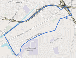
According to Google Maps, the boundaries of the currently developed portion are approximately Lincoln Boulevard and the Ballona Wetlands on the west, Ballona Creek on the north, Centinela Avenue on the east, and the Del Rey Hills bluffs (Westchester Bluffs) on the south. Playa Vista is bordered by the unincorporated enclave of Marina Del Rey to the northwest, by the community of Playa del Rey to the southwest, by Loyola Marymount University and the upland part of Westchester to the southwest, south, east and southeast, and by the Del Rey district to the northwest. [32]

Playa Vista Riparian Corridor

Bluff Creek
Bluff Creek, Playa Vista.jpg
Bluff Creek
Physical characteristics
Source 
  coordinates 33°58′54″N118°24′07″W / 33.9818°N 118.4020°W / 33.9818; -118.4020
Mouth  
  coordinates
33°57′57″N118°25′38″W / 33.96594°N 118.42711°W / 33.96594; -118.42711

Bluff Creek is a stream in Los Angeles County, California. It runs below the Westchester bluffs (Ballona Escarpment) and is considered a remnant or relic of the now-channelized Centinela Creek, a tributary of Ballona Creek. Bluff Creek is within the Playa Vista neighborhood and feeds the Freshwater Marsh of the Ballona Wetlands.

The Playa Vista Riparian Corridor, a popular spot for birdwatching [33] and fitness, surrounds this creek. The cluster of three footpaths and maintenance roads clustered around Bluff Creek, at the base of the Westchester Bluffs, is an wildlife area [33] associated with the larger Ballona Wetlands estuary and watershed. [34]

Trail map 4-mile riparian loop trail, Playa Vista.jpg
Trail map

The uppermost path, sometimes called the LMU Fire Road (a portion is legally Cabora Drive), is open to leashed dogs and is accessible from the residential neighborhood on the bluffs above via a long and steep paved ramp accessible at Altamoor & Dunbarton, as well as via Lincoln Blvd (west) and Bluff Creek Drive near Artisan Way (East). The central trail is a private maintenance road. The lowest road is a 2.5 miles (4.0 km) exercise track winding along Bluff Creek through Playa Vista passing multiple recreational areas including Ballona Discovery Park, which features outdoor exhibits describing the history and ecology of the area. [35]

The LMU Fire Road along the Westchester Bluffs above Playa Vista is a popular jogging track. LMU Fire Road, Playa Vista Riparian Corridor.jpg
The LMU Fire Road along the Westchester Bluffs above Playa Vista is a popular jogging track.

Demographics

The 2000 U.S. census counted 2,416 residents in the 1.3-square-mile (3.4 km2) Playa Vista neighborhood—an average of 1,859 people per square mile (715 people per square kilometer), a very low population density in Los Angeles, but by 2008, the city estimated that the population had increased to 6,010. The median age for residents was 37, considered old for Los Angeles; the percentage of residents aged 65 and older was among the county's highest. [30]

The neighborhood was highly diverse ethnically. The breakdown was Latinos, 34.8%; whites, 32.4%; Asians, 21.2%; blacks, 4.7%, and others, 6.9%. Mexico (36.2%) and Guatemala (16.5%) were the most common places of birth for the 31.1% of the residents who were born abroad, about an average figure in Los Angeles. [30]

The median yearly household income in 2008 dollars was $68,597, a high figure for Los Angeles. The average household size of 2.4 people was average for the city. House- or apartment owners occupied 54.8% of the housing stock, and renters occupied 28.5%. [30]

The percentages of divorced men and widowed men and women were among the county's highest. In 2000 there were 33 families headed by single parents, a low rate for Los Angeles. There were 215 veterans, or 11%, a high rate for Los Angeles. [30]

Economy

Commercial activity within Playa Vista:

Area businesses:

Other related activity:

Facilities

Los Angeles International Airport and surrounding areas, July 2021. Playa Vista is in the center of the photo just above where the freeways cross. Los Angeles International Airport and surrounding areas, July 2021.jpg
Los Angeles International Airport and surrounding areas, July 2021. Playa Vista is in the center of the photo just above where the freeways cross.

City

Parks

Other

Education

Los Angeles Unified School District operates public schools. [61]

Los Angeles Public Library operates the Playa Vista Branch Library. [64]

Related Research Articles

<span class="mw-page-title-main">Culver City, California</span> City in Los Angeles County, California, US

Culver City is a city in Los Angeles County, California, United States. As of the 2020 census, the population was 40,779.

<span class="mw-page-title-main">Marina del Rey, California</span> Census-designated place in the United States

Marina del Rey is an unincorporated seaside community in Los Angeles County, California, with an eponymous harbor that is a major boating and water recreation destination of the greater Los Angeles area. The port is North America's largest man-made small-craft harbor and is home to approximately 5,000 boats. The area is a popular tourism destination for both land and water activities such as paddle board and kayak rentals, dining cruises, and yacht charters. Land activities include bicycling on several bicycle paths, walking paths along the waterfront, and birdwatching (birding). Wildlife watching opportunities include California sea lions and harbor seals. Dolphins and whales occasionally visit the deeper waters of harbor. This Westside locale is approximately 4 miles (6.4 km) south of Santa Monica, 4 miles (6.4 km) north of Los Angeles International Airport, and 12.5 miles (20.1 km) west-southwest of Downtown Los Angeles.

<span class="mw-page-title-main">Playa del Rey, Los Angeles</span> Neighborhood of Los Angeles in California, United States

Playa del Rey is a seaside suburb in the Santa Monica Bay and the South Bay region of Los Angeles County, California. It has a ZIP code of 90293 and area codes of 310 and 424. As of 2018, the community had a population of 16,230 people.

<span class="mw-page-title-main">Del Rey, Los Angeles</span> Neighborhood of Los Angeles in California, United States of America

Del Rey is a neighborhood in the Westside of Los Angeles, surrounded on three sides by Culver City, California. Within it lie a police station, the largest public housing complex on the Westside, a public middle school and six public elementary schools. It is served by a neighborhood council and a residents association. Del Rey, with a 32,000+ population, has a large number of military veterans.

<span class="mw-page-title-main">Ballona Creek</span> Urbanized river in Los Angeles, California, United States.

Ballona Creek is an 8.5-mile (13.7 km) channelized stream in southwestern Los Angeles County, California, United States, that was once a "year-round river lined with sycamores and willows". The urban watercourse begins in the Mid-City neighborhood of Los Angeles, flows through Culver City and Del Rey, and passes the Ballona Wetlands Ecological Preserve, the sailboat harbor Marina del Rey, and the small beachside community of Playa del Rey before draining into Santa Monica Bay. The Ballona Creek drainage basin carries water from the Santa Monica Mountains on the north, from the Baldwin Hills to the south, and as far as the Harbor Freeway (I-110) to the east.

<span class="mw-page-title-main">Hughes Airport (California)</span> US private airport operating 1940–1985

The Hughes Airport was a private airport owned by Howard Hughes for the Hughes Aircraft Company. It was located just north of the Westchester bluffs and district of Los Angeles, California, from 1940 until its closure in 1985. It was directly south of and along Jefferson Boulevard and Ballona Creek, the location of the present-day neighborhood of Playa Vista.

<span class="mw-page-title-main">Ballona Wetlands</span> Estuary and marsh in California, United States

Ballona Wetlands Ecological Reserve is a protected area that once served as the natural estuary for neighboring Ballona Creek. The 577-acre (2.34 km2) site is located in Los Angeles County, California, just south of Marina del Rey. Ballona—the second-largest open space within the city limits of Los Angeles, behind Griffith Park—is owned by the state of California and managed by the California Department of Fish and Wildlife. The preserve is bisected generally east-west by the Ballona Creek channel and bordered by the 90 Marina freeway to the east.

<span class="mw-page-title-main">Marvin Braude Bike Trail</span> Bike path in Los Angeles County, California, United States

The Marvin Braude Bike Trail is a 22-mile (35 km) paved bicycle path that runs mostly along the shoreline of Santa Monica Bay in Los Angeles County, California. The coastal bike trail is widely acknowledged as Los Angeles’ “most popular bike path.”

<span class="mw-page-title-main">Ballona Creek Bike Path</span> Cycling route in Los Angeles County, California

The Ballona Creek Bike Path is a 6.7-mile (10.8 km) Class I bicycle path and pedestrian route in California. The bike path follows the north bank of Ballona Creek until it reaches Santa Monica Bay at the Pacific Ocean. The route is defined by, and recognized for, the dramatic contrast between the channelized waterway’s stark cement geometry and the abundant wildlife of the verdant Ballona Wetlands.

<span class="mw-page-title-main">Ballona</span> Placename in Southern California

Ballona is a geographic place name in the Westside region of Los Angeles County, California.

<span class="mw-page-title-main">Rancho La Ballona</span> Historical cattle ranch in Los Angeles, California, USA

Rancho La Ballona was a 13,920-acre (56.3 km2) Mexican land grant in the present-day Westside region of Los Angeles County, Southern California.

<span class="mw-page-title-main">Culver Boulevard Median Bike Path</span> Rail-trail cycle route in California, United States

The Culver Boulevard Median Bike Path is Class I rail trail bicycle path, walk route and linear park on Culver Boulevard in western Los Angeles County, California.

<span class="mw-page-title-main">Alla, California</span> Former rail junction, archaic place name

Alla is a former streetcar station and archaic place name located near Marina del Rey in the Westside region of Los Angeles County, California.

Friends of Ballona Wetlands (FBW) is a California non-profit 501(c)(3) organization founded in 1978 by a small group of friends, scientists and neighbors who recognized the environmental value of Los Angeles County's last remaining tidal ecosystem. The organization is dedicated to preserving and protecting the Ballona Wetlands through stewardship and educating the public. The FBW partners with the California Coastal Conservancy and the California Department of Fish and Wildlife (CDFW). The FBW also partners with faculty and staff from a Catholic college, Loyola Marymount University (LMU), and with Heal The Bay. The FBW was founded in 1978, and legally continued their access in 2003, when the CDFW acquired the private Ballona Wetlands. Public access improved when the Ballona Wetlands became public land.

<span class="mw-page-title-main">Port Ballona, California</span> 19th century planned harbor of Santa Monica Bay

Port Ballona is an archaic place name for an area near the center of Santa Monica Bay in coastal Los Angeles County, where Playa Del Rey and Del Rey Lagoon are located today. Port Ballona was a planned harbor and town site from circa 1859 to 1903. The name comes from the Rancho La Ballona Mexican land grant.

<span class="mw-page-title-main">Los Angeles Clippers Training Center</span> Training facility for the Los Angeles Clippers NBA team

The Honey Training Center is a 42,500 square foot (3,950 m2) two-story training facility for the Los Angeles Clippers of the National Basketball Association (NBA). Located in the planned community of Playa Vista in Los Angeles near Loyola Marymount University, the facility is at least 1 mile (1.6 km) away from nearby beaches, 3 miles (4.8 km) north of Los Angeles International Airport, and 12 miles (19 km) southwest of Crypto.com Arena. While the team maintains some office functions at Crypto.com Arena, the Playa Vista facility serves as the official headquarters of the Clippers. The Honey Training Center is located 6 miles (9.7 km) northwest from the future Clippers arena in Inglewood, the Intuit Dome.

<span class="mw-page-title-main">Venice–Inglewood Line</span> Historic rail route in California

The Venice–Inglewood Line is a former Pacific Electric interurban railway line in Los Angeles County, California. Service was very sparse, providing a suburban route between Venice and Inglewood.

<span class="mw-page-title-main">Redondo Beach via Playa del Rey Line</span> Historic streetcar line in California

The Redondo Beach via Playa del Rey was an interurban railway route of the Pacific Electric. It operated between the Hill Street Terminal and Cliffton, south of Redondo Beach, through the company's Western Division.

<span class="mw-page-title-main">Del Rey Lagoon Park</span> Municipal park in California, US

Del Rey Lagoon Park is a 14-acre (57,000 m2) municipal park in the Playa Del Rey neighborhood of Los Angeles, United States, with a lagoon that is part of the greater Ballona Creek watershed.

<span class="mw-page-title-main">Guashna</span> Former Tongva village at Playa Vista, Los Angeles

Guashna was a Tongva village located at Playa Vista, Los Angeles at the mouth of Ballona Creek. The site has also been referred to as Sa'angna, with various sources debating whether Sa'angna, meaning "place of tar," was a regional referent rather than a village name or whether it was a separate nearby village. The initial place name was said to be Sa'an; the village suffix "ngna" was added by Bernice Johnston to her 1962 map of Gabrieleño villages "despite her having found no mention of the term in baptismal records." Sa'angna is also not to be confused with Suangna. The Tongva referred to the Ballona Wetlands as Pwinukipar, meaning "full of water." Another alternate name may Waachnga.

References

  1. Lewis, Amanda (January 23, 2014). "Playa Vista Was Going to Be a Utopian Planned Community. But Capitalism's Harsh Reality Keeps Creeping In". LA Weekly .
  2. 1 2 Vincent, Roger (December 18, 2014) "Playa Vista office complex gets makeover, draws creative tenants" Los Angeles Times
  3. Chang, Andrea (January 16, 2015) "Yahoo to move Santa Monica operations to booming tech hub Playa Vista" Los Angeles Times
  4. Logan, Tim (January 2, 2015) "Buoyed by Silicon Beach, Westchester enjoys a housing surge" Los Angeles Times
  5. Machalinski, Anne (May 22, 2019). "Los Angeles Tech Scene Expands Beyond Silicon Beach". Barrons. Retrieved July 23, 2019.
  6. 1 2 3 4 Abdollah, Tami & Song, Jason (December 14, 2008). "Restoring harmony with reburial of Native American remains". Los Angeles Times .
  7. Williams, Jennifer L (2007). "Grave Disturbances: Been Digging Lately". Public Resources. 38: 299.
  8. Lin, Sara (March 21, 2004). "State Decries Removal of Remains". Los Angeles Times .
  9. "Discovery Center celebrating the history of Westchester/Playa announces plan for fall opening - the HomeTown News". 12 August 2020.
  10. Ranchos and the Politics of Land Claims Archived 2016-01-29 at the Wayback Machine by Karen Clay and Werner Troesken
  11. "Mar Vista Historical Society" . Retrieved 25 April 2016.
  12. Masters, Nathan (February 29, 2012). "The Lost Wetlands of Los Angeles". KCET. Retrieved 16 April 2015.
  13. Purdum, Todd S. (July 3, 1999). "Spielberg and Partners Drop Long-Troubled Plan to Build Big Studio Complex". New York Times .
  14. Opinions Differ Radically on Impacts of Dreamworks' Abrupt Exit from Playa Vista Archived December 16, 2000, at archive.today
  15. 1 2 Playa Vista Moving Full Speed Ahead For Early 2001 Grand Opening Archived February 21, 2001, at archive.today
  16. Vincent, Roger and Groves, Martha (October 18, 2003) "L.A.'s Urban Model" Los Angeles Times
  17. Steve Soboroff Named President of Playa Vista
  18. 1 2 Playa Vista Unveils Visitor Center as Leading Homebuilders Move Forward With Construction; First Residents to Move in Next Year
  19. "Santa Monica News Santa Monica, Environmentalists Go to Court Over Playa Vista Expansion" . Retrieved 25 April 2016.
  20. "Developers and Environmentalists Join Forces on Wetlands". The New York Times. 31 July 1994. Retrieved 25 April 2016.
  21. "The evolution of a Ballona friendship". Archived from the original on 2013-05-25. Retrieved 25 April 2016.
  22. 1 2 3 Just How Much Gas Flows Below? [ dead link ]
  23. "Playa Vista Buyers Will Test Capability of Methane Shield; Critics call high-tech safeguards unproven. Courts back experts who devised system." Archived 2006-01-10 at the Wayback Machine
  24. La Citybeat - Bubbling Trouble Archived 2007-09-28 at the Wayback Machine
  25. 1 2 PASSING JUDGEMENT, PASSING GAS [ permanent dead link ]
  26. Groves, Martha (January 06, 2003) "Playa Vista Buyers Will Test Capability of Methane Shield" Los Angeles Times'
  27. "Reclaimed water now irrigates landscaped open spaces in Playa Vista". Daily Breeze . April 8, 2009. Archived from the original on 2009-04-13. Retrieved 2009-04-19.
  28. "Westside," Mapping L.A., Los Angeles Times
  29. "South Bay," Mapping L.A., Los Angeles Times
  30. 1 2 3 4 5 "Playa Vista," Mapping L.A., Los Angeles Times
  31. The Thomas Guide: Los Angeles County, 2004, pages 672 and 702
  32. "Google Maps" . Retrieved 25 April 2016.
  33. 1 2 "Playa Vista Riparian Corridor, Los Angeles County, CA, US - eBird Hotspot". ebird.org. Retrieved 2022-08-11.
  34. "The Village at Playa Vista EIR" (PDF). 2008.
  35. "Bluff Creek Trail". AllTrails.com. Retrieved 2022-08-10.
  36. "Los Angeles (EALA)" . Retrieved 25 April 2016.
  37. Vincent, Roger (August 28, 2014) "Prominent L.A. developer to build unconventional office at Playa Vista" Los Angeles Times
  38. "Belkin Moves Corporate Headquarters to Playa Vista" (Press release). Business Wire. March 22, 2010.
  39. Vincent, Roger (September 30, 2013) "Ad agency Team One rents headquarters space near Playa Vista" Los Angeles Times
  40. Vincent, Roger and Chang, Andrea (December 3, 2014) "Google buys 12 acres in Playa Vista, vastly expands presence in L.A." Los Angeles Times
  41. "5353 Grosvenor Boulevard, Los Angeles, CA 90066" . Retrieved 25 April 2016.
  42. "TBWA\CHIAT\DAY". Archived from the original on 10 June 2007. Retrieved 25 April 2016.
  43. Deutsch. "Deutsch: An Integrated Advertising, Design, and Digital Agency. New York and Los Angeles" . Retrieved 25 April 2016.
  44. Gehry Partners
  45. TOMS. "The One for One Company - TOMS" . Retrieved 25 April 2016.
  46. 1 2 3 4 5 6 "Get to Know the Area - Playa Vista". Playa Vista. Retrieved 25 April 2016.
  47. Futch, David (2016-06-30). "How Snoop Dogg Is Becoming a Marijuana Media Mogul". L.A. Weekly. Retrieved 2017-10-12.
  48. "Contacts". www.imax.com. 2015-09-01. Retrieved 2019-01-25.
  49. "Location" . Retrieved 25 April 2016.
  50. "Pacific Community Police Station" . Retrieved 25 April 2016.
  51. Playa Vista Branch (LAPL)
  52. http://www.yelp.com/biz/playa-vista-dog-park-playa-vista Playa Vista Dog
  53. http://www.yelp.com/biz/playa-vista-sports-park-playa-vista Playa Vista Sports Park
  54. http://www.yelp.com/biz/fountain-park-at-playa-vista-playa-vista Fountain Park At Playa Vista
  55. http://www.shapedscape.com/projects/playa-vista-park Archived 2016-01-10 at the Wayback Machine Playa Vista Central Park
  56. Bike Paths of Los Angeles: Ballona Creek Archived 2010-04-16 at the Wayback Machine
  57. "Ballona Discovery Park - Playa Vista - Los Angeles, CA". Yelp. Retrieved 2022-12-12.
  58. "Concert Park - Playa Vista - Los Angeles, CA". Yelp. Retrieved 2019-01-25.
  59. "CLIPPERS: Clippers' Training Center Press Conference Transcript". NBA.com . Retrieved 25 April 2016.
  60. "CLIPPERS: Clippers Training Center Update". NBA.com . Retrieved 25 April 2016.
  61. "Playa Vista". Los Angeles Times . Retrieved 2023-03-17.
  62. "Home". Playa del Rey Elementary School. Retrieved 2023-03-17. 12221 Juniette Street Culver City, California 90230 - Despite the Culver City address, it is not in Culver City.
  63. "Home". Playa Vista Elementary School. Retrieved 2023-04-30.
  64. "Playa Vista". Los Angeles Public Library . Retrieved 2023-04-30.

Notes